Difference between revisions of "Nebraska" - New World Encyclopedia
Mary Anglin (talk | contribs) |
Rosie Tanabe (talk | contribs) |
||
| (45 intermediate revisions by 3 users not shown) | |||
| Line 1: | Line 1: | ||
| − | {{Ready}}{{Images OK}} | + | {{Ready}}{{Images OK}}{{Approved}}{{Copyedited}} |
| − | {{Infobox U.S. state | | + | {{Infobox U.S. state |
| − | + | | Name = Nebraska | |
| − | + | | Fullname = State of Nebraska | |
| − | + | | Flag = Flag of Nebraska.svg | |
| − | + | | Seal = Nebraskastateseal.jpg | |
| − | + | | Map = Map of USA NE.svg | |
| − | + | | Nickname = Cornhusker State | |
| − | + | | Former = Nebraska Territory | |
| − | + | | Motto = [[Equality before the law|Equality Before the Law]] | |
| − | + | | Capital = [[Lincoln, Nebraska|Lincoln]] | |
| − | + | | OfficialLang = English | |
| − | + | | Demonym = Nebraskan | |
| − | + | | LargestCity = [[Omaha, Nebraska|Omaha]] | |
| − | + | | LargestMetro = [[Omaha-Council Bluffs metropolitan area|Omaha-Council Bluffs]] | |
| − | + | | Governor = [[Dave Heineman]] (R) | |
| − | + | | Lieutenant Governor = [[Rick Sheehy]] (R) | |
| − | + | | Legislature = [[Nebraska Legislature]] | |
| − | + | | Upperhouse = ''None'' ([[Unicameral legislature|unicameral]]) | |
| − | + | | Lowerhouse = ''None'' (unicameral) | |
| − | + | | Senators = [[Ben Nelson]] (D)<br />[[Mike Johanns]] (R) | |
| − | + | | Representative = [[Jeff Fortenberry]] (R)<br />[[Lee Terry]] (R)<br />[[Adrian M. Smith]] (R) | |
| − | + | | PostalAbbreviation = NE | |
| − | + | | AreaRank = 16th | |
| − | + | | TotalAreaUS = 77,354 | |
| − | + | | TotalArea = 200,520 | |
| − | + | | LandAreaUS = 76,873 | |
| − | + | | LandArea = 199,099 | |
| − | + | | WaterAreaUS = 481 | |
| − | + | | WaterArea = 1,247 | |
| − | + | | PCWater = 0.7 | |
| − | + | | PopRank = 38th | |
| − | + | | 2000Pop = 1,842,641 (2011 est)<ref name=PopEstUS>{{cite web|url=|title=Annual Estimates of the Resident Population for the United States, Regions, States, and Puerto Rico: April 1, 2010 to July 1, 2011|format=[[comma-separated values|CSV]]|work=2011 Population Estimates|publisher=[[United States Census Bureau]], Population Division|date=December 2011}}</ref> | |
| − | + | | DensityRank = 43rd | |
| − | + | | 2000DensityUS = 24.0 | |
| − | + | | 2000Density = 9.25 | |
| − | + | | MedianHouseholdIncome = $44,623 | |
| − | + | | IncomeRank = 20th | |
| − | + | | AdmittanceOrder = 37th | |
| − | + | | AdmittanceDate = March 1, 1867 | |
| − | + | | TimeZone = [[Central Standard Time Zone|Central]]: [[UTC]]-6/[[Daylight saving time|-5]] | |
| − | + | | TZ1Where = most of state | |
| − | + | | TimeZone2 = [[Mountain Standard Time Zone|Mountain]]: [[UTC]]-7/[[Daylight saving time|-6]] | |
| − | + | | TZ2Where = [[Nebraska Panhandle|panhandle]] | |
| − | + | | Latitude = [[40th parallel north|40° N]] to [[43rd parallel north|43° N]] | |
| − | + | | Longitude = 95° 19' W to 104° 03' W | |
| − | + | | WidthUS = 210 | |
| − | + | | Width = 340 | |
| − | + | | LengthUS = 430 | |
| − | + | | Length = 690 | |
| − | + | | HighestPoint = [[Panorama Point]]<ref name=USGS>{{cite web|url=http://egsc.usgs.gov/isb/pubs/booklets/elvadist/elvadist.html|title=Elevations and Distances in the United States|publisher=[[United States Geological Survey]]|year=2001|accessdate=October 24, 2011}}</ref><ref name=NAVD88>Elevation adjusted to [[North American Vertical Datum of 1988]].</ref> | |
| − | + | | HighestElevUS = 5,427 | |
| − | + | | HighestElev = 1654 | |
| − | + | | MeanElevUS = 2,600 | |
| − | + | | MeanElev = 790 | |
| + | | LowestPoint = [[Missouri River]] at {{nobreak|[[Kansas]] border}}<ref name=USGS/><ref name=NAVD88/> | ||
| + | | LowestElevUS = 840 | ||
| + | | LowestElev = 256 | ||
| + | | ISOCode = US-NE | ||
| + | | Website = www.nebraska.gov | ||
}} | }} | ||
| + | '''Nebraska''' is a state located on the [[Great Plains]] of the [[United States of America]]. Once considered part of the [[Great American Desert]], it is now one of the leading [[agriculture|agricultural]] states in the nation, having mastered systems of [[irrigation]] that allow it to use its abundance of [[groundwater]] for farming and [[ranch]]ing. | ||
| − | + | Originally home to the [[Plains Indians]], the area was part of Louisiana Territory and was included in the [[Louisiana Purchase]] of 1803. White settlement began in the mid-1800s. The Nebraska Territory was established by the [[Kansas-Nebraska Act]] of 1854 and lasted until it became the 37th state on March 1, 1867. | |
| − | + | {{toc}} | |
| − | + | Most of the state's population lives along its eastern edge, with 58 percent residing in the two main metropolitan areas of Omaha and Lincoln. Much of the remainder of the state is wide open prairie grassland, however, her waters - the [[Missouri River|Missouri]], [[Platte River|Platte]] and [[Niobrara River]]s - have defined her history, culture, and settlement patterns. | |
== Geography == | == Geography == | ||
| Line 76: | Line 82: | ||
Nebraska is located in [[Tornado Alley]]; [[thunderstorm]]s are common in the spring and summer months. The [[chinook wind]]s from the [[Rocky Mountains]] provide a temporary moderating effect on temperatures in western Nebraska during the winter months. <ref>''Twin Cities Development Association''. [http://www.tcdne.org/climate.htm Climate] Retrieved May 2, 2008.</ref> | Nebraska is located in [[Tornado Alley]]; [[thunderstorm]]s are common in the spring and summer months. The [[chinook wind]]s from the [[Rocky Mountains]] provide a temporary moderating effect on temperatures in western Nebraska during the winter months. <ref>''Twin Cities Development Association''. [http://www.tcdne.org/climate.htm Climate] Retrieved May 2, 2008.</ref> | ||
| − | The [[National Wildlife Federation]] has found that [[global warming]] could have a harmful effect on Nebraska's ecology and economy, promoting the kinds of [[drought]] that led to the [[Dust Bowl]] conditions of the 1930s and increasing the population and active season of disease-carrying [[mosquito]]s. <ref name=NWF> ''National Wildlife Federation''. March 24, 2008. | + | The [[National Wildlife Federation]] has found that [[global warming]] could have a harmful effect on Nebraska's ecology and economy, promoting the kinds of [[drought]] that led to the [[Dust Bowl]] conditions of the 1930s and increasing the population and active season of disease-carrying [[mosquito]]s. <ref name=NWF> ''National Wildlife Federation''. March 24, 2008. Global Warming and Nebraska </ref> |
===Flora and fauna=== | ===Flora and fauna=== | ||
| − | Nebraska is home to an incredible diversity of native wildlife species, including 346 [[bird]]s, 83 [[mammal]]s, 87 [[fish]], 47 [[reptile]]s and 13 [[amphibian]]s. <ref name=NWF/>. This includes such animals as the [[beaver]], [[bobcat]], [[Bear|black bear]], [[coyote]], [[mink]], [[mountain lion]], [[muskrat]], [[opossum]], [[raccoon]], [[Otter|river otters]], [[Ferret|black-footed ferret]], [[mountain plover]], [[Tern|least tern]], [[bald eagle]]s, [[Crane|sandhills cranes]], | + | Nebraska is home to an incredible diversity of native wildlife species, including 346 [[bird]]s, 83 [[mammal]]s, 87 [[fish]], 47 [[reptile]]s and 13 [[amphibian]]s. <ref name=NWF/>. This includes such animals as the [[beaver]], [[bobcat]], [[Bear|black bear]], [[coyote]], [[mink]], [[mountain lion]], [[muskrat]], [[opossum]], [[raccoon]], [[Otter|river otters]], [[Ferret|black-footed ferret]], [[mountain plover]], [[Tern|least tern]], [[bald eagle]]s, [[Crane|sandhills cranes]], whooping cranes, [[Quail|bobwhite quail]], [[prairie dog]]s, [[Rabbit|cottontail rabbit]], [[flying squirrel|southern flying squirrel]], [[Deer|white-tailed deer]], mule deer, [[pronghorn antelope]], [[turkey]], [[elk]] and [[bighorn sheep]]. <ref>''Nebraska Game and Parks Commission''. [http://www.ngpc.state.ne.us/wildlife/newildlife.asp Nebraska Wildlife Species] Retrieved May 2, 2008.</ref> There are numerous programs in the state that serve to protect wildlife as well as to educate the state's youth on such care. |
===Landscapes=== | ===Landscapes=== | ||
| Line 89: | Line 95: | ||
[[Image:IMG 0340.JPG|right|thumb|270px|Toadstool Park in 2006]] | [[Image:IMG 0340.JPG|right|thumb|270px|Toadstool Park in 2006]] | ||
| − | The Sand Hills is a region of mixed-grass [[prairie]] in north-central Nebraska, covering just over one quarter of the state. | + | The Sand Hills is a region of mixed-grass [[prairie]] in north-central Nebraska, covering just over one quarter of the state. The region is variously defined by different organizations, but its size is generally accepted as between 20,000 to 24,000 square miles in size (50,000 - 61,100 sq km). The Hills lie mostly to the north of the Platte and North Platte rivers, with the Niobrara River passing through the northern sections and forming part of the northeastern boundary. The western and northern Sand Hills are dotted with small lakes and wetlands. <ref name="WWF">''World Wildlife Fund''. |
[http://www.nationalgeographic.com/wildworld/profiles/terrestrial/na/na0809.html Nebraska Sand Hills mixed grasslands (NA0809)] Retrieved May 2, 2008.</ref> | [http://www.nationalgeographic.com/wildworld/profiles/terrestrial/na/na0809.html Nebraska Sand Hills mixed grasslands (NA0809)] Retrieved May 2, 2008.</ref> | ||
| − | The [[World Wide Fund for Nature]] (WWF) designated the Sand Hills as an [[ecoregion]], distinct from other grasslands of the Great Plains. The area contains a distinct grassland association dominated by sand bluestem (Andropogon hallii), Calamovilfa longifolia, and needleandthread (Stipa comata). According to their assessment, as much as 85 percent of the Sand Hills ecoregion is intact natural habitat, the highest level in the Great Plains, due primarily due to the lack of [[agriculture]]. | + | The [[World Wide Fund for Nature]] (WWF) designated the Sand Hills as an [[ecoregion]], distinct from other grasslands of the Great Plains. The area contains a distinct grassland association dominated by sand bluestem (Andropogon hallii), Calamovilfa longifolia, and needleandthread (Stipa comata). According to their assessment, as much as 85 percent of the Sand Hills ecoregion is intact natural habitat, the highest level in the Great Plains, due primarily due to the lack of [[agriculture]]. Most of the Sand Hills land have never been plowed. <ref name="WWF"/> |
Today, the Sand Hills are among the most productive [[cattle]] ranching areas of the world. The population of the region continues to decline as older generations age and as younger generations move to the cities. However, there are still a number of small towns in the region that celebrate both their cultural heritage and their physical location. | Today, the Sand Hills are among the most productive [[cattle]] ranching areas of the world. The population of the region continues to decline as older generations age and as younger generations move to the cities. However, there are still a number of small towns in the region that celebrate both their cultural heritage and their physical location. | ||
====Oglala National Grassland==== | ====Oglala National Grassland==== | ||
| − | The Oglala National Grassland is a grassland located in the northwestern part of the state, in Sioux County near the border of [[South Dakota]]. | + | The Oglala National Grassland is a grassland located in the northwestern part of the state, in Sioux County near the border of [[South Dakota]]. It is 94,400 acres (382 km²) in size and is one of the small handful of National Grasslands administered by the [[Department of Agriculture|US Department of Agriculture's]] [[United States Forest Service|Forest Service]]. |
| − | Oglala National Grassland is also home to some of the most striking badlands formations in [[Toadstool Geologic Park]] near the towns of Crawford and Whitney. Additionally, the [[Hudson-Meng Bison Kill]], also located on the grassland, is an [[archaeology|archaeological]] excavation in progress. The grassland contains the Agate, Bordgate, and Rock Bass reservoirs. | + | Oglala National Grassland is also home to some of the most striking [[badlands]] formations in [[Toadstool Geologic Park]] near the towns of Crawford and Whitney. Additionally, the [[Hudson-Meng Bison Kill]], also located on the grassland, is an [[archaeology|archaeological]] excavation in progress. The grassland contains the Agate, Bordgate, and Rock Bass reservoirs. |
====Toadstool Geologic Park==== | ====Toadstool Geologic Park==== | ||
| − | Toadstool Geologic Park is located in the Oglala National Grassland and is operated by the [[United States Forest Service]]. It contains a [[badlands]] landscape and a reconstructed [[sod house]]. | + | Toadstool Geologic Park is located in the Oglala National Grassland and is operated by the [[United States Forest Service]]. It contains a [[badlands]] landscape and a reconstructed [[sod house]]. The park is named after its unusual rock formations, many of which resemble [[Amanita muscaria|toadstools]]. It is also sometimes called the "badlands of Nebraska" or the "desert of the Pine Ridge." The park is rich in [[fossil]]s. |
====Nebraska National Forest==== | ====Nebraska National Forest==== | ||
| − | The Nebraska National Forest comprises two ranger districts. | + | The Nebraska National Forest comprises two ranger districts. The {{convert|90000|acre|sqkm|0|adj=on}} Bessey Ranger District is located in the Sandhills section. This area was established in 1902 by [[Charles E. Bessey]] as an experiment to see if [[forest]]s could be created in treeless areas of the [[Great Plains]] for use as a national timber reserve. This effort resulted in a {{convert|20000|acre|sqkm|1|adj=on}} forest, the largest human-planted forest in the United States. Today, the forest's nursery supplies 2.5 to 3 million seedlings per year and is listed on the [[National Register of Historic Places]]. |
| − | The {{convert|52000|acre|sqkm|0}} Pine Ridge Ranger District is located in Nebraska's Pine Ridge region. The native [[Ponderosa Pine|ponderosa]] forests were added to the National Forest system in the 1950s. The [[Soldier Creek Wilderness]], a federally designated wilderness area, is located in the forest. | + | The {{convert|52000|acre|sqkm|0}} Pine Ridge Ranger District is located in Nebraska's Pine Ridge region. The native [[Ponderosa Pine|ponderosa]] forests were added to the National Forest system in the 1950s. The [[Soldier Creek Wilderness]], a federally designated [[wilderness]] area, is located in the forest. |
====Niobrara National Scenic River==== | ====Niobrara National Scenic River==== | ||
[[Image:SmithFallsNE.jpg|thumb|270px|left|Smith Falls is the tallest waterfall in Nebraska.]] | [[Image:SmithFallsNE.jpg|thumb|270px|left|Smith Falls is the tallest waterfall in Nebraska.]] | ||
| − | The Niobrara National Scenic River is located in north-central Nebraska, near the South Dakota border, approximately 300 miles northwest of [[Omaha, Nebraska|Omaha]]. | + | The Niobrara National Scenic River is located in north-central Nebraska, near the South Dakota border, approximately 300 miles northwest of [[Omaha, Nebraska|Omaha]]. In 1991, [[U.S. Congress|Congress]] set aside 76 miles (120 km) along two stretches of the [[Niobrara River]] for preservation under the management of the [[National Park Service]]. The [[river]] was designated by ''Backpacker'' magazine as one of the 10 best rivers for [[canoeing]] in the United States. |
| − | Along the scenic section of the river are numerous [[waterfall]]s that empty into the [[river]] from the surrounding [[canyon]] walls; the highest one is [[Smith Falls]], which drops 63 feet (19 m) into the river valley. | + | Along the scenic section of the river are numerous [[waterfall]]s that empty into the [[river]] from the surrounding [[canyon]] walls; the highest one is [[Smith Falls]], which drops 63 feet (19 m) into the river valley. There are short sections of Class I and II [[rapids]] on the river itself, and several locations further downstream require a [[portage]] around the rapids. The westernmost 26 miles (40 km) of the Scenic River section, from the [[Fort Niobrara National Wildlife Refuge]] to the Rocky Ford portage, offer outstanding canoeing, [[kayaking]], [[tubing (recreation)|tubing]] and [[fishing]] opportunities. |
Considered a superb example of a [[Great Plains]] river, the Niobrara is home to over 500 plant [[species]] including many not otherwise found within several hundred miles, including [[birch]], [[ponderosa pine]] and [[aspen]] (both quaking and bigtooth species). [[Mule deer]], [[beaver]], [[mink]], [[antelope]], [[coyote]] and even [[American bison|bison]] can be found. Approximately 400 bison and a few dozen [[elk]] are protected in the 19,000 acre (77 km²) Fort Niobrara National Wildlife Refuge, which is located along the river. | Considered a superb example of a [[Great Plains]] river, the Niobrara is home to over 500 plant [[species]] including many not otherwise found within several hundred miles, including [[birch]], [[ponderosa pine]] and [[aspen]] (both quaking and bigtooth species). [[Mule deer]], [[beaver]], [[mink]], [[antelope]], [[coyote]] and even [[American bison|bison]] can be found. Approximately 400 bison and a few dozen [[elk]] are protected in the 19,000 acre (77 km²) Fort Niobrara National Wildlife Refuge, which is located along the river. | ||
| Line 121: | Line 127: | ||
At the time of European exploration of the [[Midwestern United States|American Midwest]], the area that became Nebraska was occupied by several [[Native American]] tribes; the [[Sioux]], [[Ioway]] [[Missouri (tribe)|Missouri]], [[Omaha (tribe)|Omaha]], [[Ponca]], [[Otoe]] and [[Pawnee]]. | At the time of European exploration of the [[Midwestern United States|American Midwest]], the area that became Nebraska was occupied by several [[Native American]] tribes; the [[Sioux]], [[Ioway]] [[Missouri (tribe)|Missouri]], [[Omaha (tribe)|Omaha]], [[Ponca]], [[Otoe]] and [[Pawnee]]. | ||
| − | By 1775, the Omaha were a powerful military force and wielded great influence. In 1800 they fell victim to a [[smallpox]] [[epidemic]] that decimated the tribe and destroyed its regional power. Nearly two-thirds of the tribe perished, including Chief [[Black Bird]]. Two years later a second epidemic hit reducing the tribe's numbers further. <ref name=history> Liz Rea. | + | By 1775, the Omaha were a powerful military force and wielded great influence. In 1800 they fell victim to a [[smallpox]] [[epidemic]] that decimated the tribe and destroyed its regional power. Nearly two-thirds of the tribe perished, including Chief [[Black Bird]]. Two years later a second epidemic hit reducing the tribe's numbers further. <ref name=history> Liz Rea. 2007. "History at a glance" ''Douglas County Historical Society''.</ref> Suffering cultural degradation, disease, the elimination of the [[American bison|buffalo]], and continued property loss, in 1856 the [[Omaha]] sold the last of their claims in the city named for them and relocated to their present [[reservation]] north in [[Thurston County, Nebraska]]. |
===Exploration and settlement=== | ===Exploration and settlement=== | ||
| − | In the latter half of the | + | In the latter half of the seventeenth century European explorers came to the territory. In 1682 Sieur [[de La Salle]] claimed all the territory drained by the [[Mississippi River]] and its tributaries for [[France]], thus creating the [[Louisiana Territory]]. In the Treaty of Fontainebleau of 1762, France ceded its holdings west of the Mississippi (including Nebraska) to [[Spain]]. This was reversed in 1800 when Spain returned the [[Louisiana Territory]] to France. |
The [[United States]] purchased the [[Louisiana Territory]] from France for $15,000,000 under terms of the [[Treaty of Paris]] in 1803, making what became Nebraska the property of the United States for the first time. In 1812 President [[James Madison]] signed a bill creating the [[Missouri Territory]], including the present-day state of Nebraska. Trading posts and forts began to spring up. In 1822 the [[Missouri Fur Company]] built a headquarters and trading post about nine miles north of the mouth of the Platte River and called it [[Bellevue, Nebraska|Bellevue]], establishing the first town in Nebraska. Bellevue’s location | The [[United States]] purchased the [[Louisiana Territory]] from France for $15,000,000 under terms of the [[Treaty of Paris]] in 1803, making what became Nebraska the property of the United States for the first time. In 1812 President [[James Madison]] signed a bill creating the [[Missouri Territory]], including the present-day state of Nebraska. Trading posts and forts began to spring up. In 1822 the [[Missouri Fur Company]] built a headquarters and trading post about nine miles north of the mouth of the Platte River and called it [[Bellevue, Nebraska|Bellevue]], establishing the first town in Nebraska. Bellevue’s location | ||
facilitated the company’s trade with the local tribes and served as a way station and supply depot for its trade ventures into the fur-rich lands of the Upper Missouri. <ref name=history/> | facilitated the company’s trade with the local tribes and served as a way station and supply depot for its trade ventures into the fur-rich lands of the Upper Missouri. <ref name=history/> | ||
| − | In 1842 [[John C. Frémont]] completed his exploration of the Platte River country with [[Kit Carson]] in Bellevue. On this cartography trip, Frémont used the Otoe word ''Nebrathka'' to designate the [[Platte River]]. Platte is from the French word for "flat" | + | In 1842 [[John C. Frémont]] completed his exploration of the Platte River country with [[Kit Carson]] in Bellevue. On this cartography trip, Frémont used the Otoe word ''Nebrathka'' to designate the [[Platte River]]. Platte is from the French word for "flat," the translation of Ne-brath-ka meaning "land of flat waters." In 1844 the name “Nebraska” was used for the first time in an official capacity by William Wilkins, then U.S. Secretary of War. <ref name=history/> |
=== The Kansas-Nebraska Act === | === The Kansas-Nebraska Act === | ||
| Line 135: | Line 141: | ||
The concept of [[Manifest Destiny]] played a part in the formation of the [[Kansas-Nebraska Act]] of 1854. There were those, such as Senator [[Stephen A. Douglas]] of [[Illinois]], who believed that the United States had both a right and obligation to take over as much land as possible and to spread its "civilizing" influence. He believed that those who stood in the way of the "advancement" of the U.S. should be removed. | The concept of [[Manifest Destiny]] played a part in the formation of the [[Kansas-Nebraska Act]] of 1854. There were those, such as Senator [[Stephen A. Douglas]] of [[Illinois]], who believed that the United States had both a right and obligation to take over as much land as possible and to spread its "civilizing" influence. He believed that those who stood in the way of the "advancement" of the U.S. should be removed. | ||
| − | The government planned to build a transcontinental railroad, especially following the discovery of [[gold]] in [[California]]. For such a railroad to be built, the territory of | + | The government planned to build a transcontinental railroad, especially following the discovery of [[gold]] in [[California]]. For such a railroad to be built, the territory of Nebraska had to be secured and organized. For this to take place, [[Native American]]s would need to be removed from the territory. |
| − | Douglas needed sufficient votes to support the organization of Nebraska territory. To do so, he devised a plan to gain support from the Southern voters. He thus proposed a bill of re-organization of the Nebraska-Kansas territory which included the stipulation that the slavery question of the new territories created would be decided by popular sovereignty. Nebraska was far enough north that it's status as a free state would be secure. However, Kansas lay directly west of the state of [[Missouri]], a slave state. <ref> ''PBS Online''. [http://www.pbs.org/wgbh/aia/part4/4p2952.html Bleeding Kansas] Retrieved May 6, 2008. </ref> | + | Douglas needed sufficient votes to support the organization of Nebraska territory. To do so, he devised a plan to gain support from the Southern voters. He thus proposed a bill of re-organization of the Nebraska-Kansas territory which included the stipulation that the slavery question of the new territories created would be decided by popular sovereignty. Nebraska was far enough north that it's status as a free state would be secure. However, Kansas lay directly west of the state of [[Missouri]], a [[slavery|slave]] state. <ref> ''PBS Online''. [http://www.pbs.org/wgbh/aia/part4/4p2952.html Bleeding Kansas] Retrieved May 6, 2008. </ref> |
| − | On May 30, 1854 the [[Kansas-Nebraska Act]] became law, establishing the U.S. territories of Nebraska and [[Kansas]] and opened new lands for settlement. The act established the [[40th parallel north]] as the dividing line between the territories of Kansas and Nebraska. As such, the original territorial boundaries of Nebraska were much larger than today; the territory was bounded on the west by the [[Continental Divide]]; on the north by the [[49th parallel north]] (the boundary between the [[United States]] and [[Canada]], and on the east by the [[White Earth]] and [[Missouri River|Missouri]] rivers. | + | On May 30, 1854 the [[Kansas-Nebraska Act]] became law, establishing the U.S. territories of Nebraska and [[Kansas]] and opened new lands for settlement. The act established the [[40th parallel north]] as the dividing line between the territories of Kansas and Nebraska. As such, the original territorial boundaries of Nebraska were much larger than today; the territory was bounded on the west by the [[Continental Divide]]; on the north by the [[49th parallel north]] (the boundary between the [[United States]] and [[Canada]], and on the east by the [[White Earth]] and [[Missouri River|Missouri]] rivers. |
===Nebraska Territory=== | ===Nebraska Territory=== | ||
| Line 146: | Line 152: | ||
In the 1860s, the first great wave of [[Homestead Act|homesteader]]s poured into Nebraska to claim free land granted by the federal government. Many of the first farm settlers built their homes out of [[sod]] because they found so few trees on the grassy land. | In the 1860s, the first great wave of [[Homestead Act|homesteader]]s poured into Nebraska to claim free land granted by the federal government. Many of the first farm settlers built their homes out of [[sod]] because they found so few trees on the grassy land. | ||
| − | [[Slavery]] in Nebraska was short and limited. The issue was contentious for the legislature between the creation of the [[Nebraska Territory]] in 1854 and the outbreak of the [[American Civil War]] in 1861. However, there was apparently a particular acceptance of African Americans in the | + | [[Slavery]] in Nebraska was short and limited. The issue was contentious for the legislature between the creation of the [[Nebraska Territory]] in 1854 and the outbreak of the [[American Civil War]] in 1861. However, there was apparently a particular acceptance of [[African Americans]] in the Nebraska Territory when they first arrived ''en masse.'' According to a publication by the [[Federal Writers Project]], |
| − | + | <blockquote>"In the Territory of Nebraska the fight to exclude slavery from within the territorial boundaries spread from the Senate to the press and to the pulpit. Even among the slaves in the South the word spread that here was a place where the attitude toward Negroes was tempered with tolerance." <ref> ''Works Progress Administration''. 1939. [http://www.memoriallibrary.com/NE/Ethnic/Negro/immigration.htm The Negroes of Nebraska] Retrieved May 6, 2008. </ref></blockquote> | |
====Landmarks of the Nebraska Territory==== | ====Landmarks of the Nebraska Territory==== | ||
| − | Landmarks of the Nebraska Territory were important to settlers on the [[Oregon Trail|Oregon]], [[California Trail|California]] and [[Mormon Trail|Mormon]] [[trail]]s. While the majority of the landmarks were close to the [[Platte River]], others were spread across the state. <ref> Nebraska Chapter of Oregon-California Trails Association. [http://incolor.inebraska.com/gnelson/neocta.html Nebraska Trail Sites] Retrieved May 6, 2008. </ref> The Oregon and California Trails entered the territory from the south (Kansas Territory) and continued east/northeasterly across present-day Nebraska. The | + | Landmarks of the Nebraska Territory were important to settlers on the [[Oregon Trail|Oregon]], [[California Trail|California]] and [[Mormon Trail|Mormon]] [[trail]]s. While the majority of the landmarks were close to the [[Platte River]], others were spread across the state. <ref> ''Nebraska Chapter of Oregon-California Trails Association''. [http://incolor.inebraska.com/gnelson/neocta.html Nebraska Trail Sites] Retrieved May 6, 2008. </ref> The Oregon and California Trails entered the territory from the south (Kansas Territory) and continued east/northeasterly across present-day Nebraska. The Mormon Trail entered the Nebraska Territory from its eastern border, across the [[Missouri River]] from Kanesville, [[Iowa]]. It continued easterly along the [[Elkhorn River|Elkhorn]] and Platte [[River]]s. |
| − | |||
| − | |||
| − | |||
| − | |||
| − | |||
| − | |||
| − | |||
===Statehood=== | ===Statehood=== | ||
A constitution for Nebraska was drawn up in 1866. There was some controversy over Nebraska's admission as a state, essentially over a provision in the 1866 constitution that restricted [[suffrage]] to white voters; eventually, on February 8, 1867, the [[United States Congress]] voted to admit Nebraska as a state provided that suffrage was not denied to non-white voters. The bill admitting Nebraska as a state was vetoed by [[President of the United States|President]] [[Andrew Johnson]], but the veto was overridden by a [[supermajority]] in both Houses of Congress. <ref> Ted and Carole Miller. [http://www.kancoll.org/books/andreas_ne/territory/territory-p8.html#veto Nebraska as a Territory] ''Andreas' History of the State of Nebraska.'' Retrieved May 6, 2008. </ref> | A constitution for Nebraska was drawn up in 1866. There was some controversy over Nebraska's admission as a state, essentially over a provision in the 1866 constitution that restricted [[suffrage]] to white voters; eventually, on February 8, 1867, the [[United States Congress]] voted to admit Nebraska as a state provided that suffrage was not denied to non-white voters. The bill admitting Nebraska as a state was vetoed by [[President of the United States|President]] [[Andrew Johnson]], but the veto was overridden by a [[supermajority]] in both Houses of Congress. <ref> Ted and Carole Miller. [http://www.kancoll.org/books/andreas_ne/territory/territory-p8.html#veto Nebraska as a Territory] ''Andreas' History of the State of Nebraska.'' Retrieved May 6, 2008. </ref> | ||
| − | After its admission to the Union in 1867, Nebraska's population increased from about 120,000 to more than 1,000,000 by 1890. The frontier opened up as Indian resistance broke, allowing settlement to move westward into the state's panhandle region. <ref name=EB> ''Encyclopædia Britannica Online''. 2008. | + | After its admission to the Union in 1867, Nebraska's population increased from about 120,000 to more than 1,000,000 by 1890. The frontier opened up as Indian resistance broke, allowing settlement to move westward into the state's panhandle region. <ref name=EB> ''Encyclopædia Britannica Online''. 2008. Nebraska. </ref> |
===Recent history=== | ===Recent history=== | ||
| Line 168: | Line 167: | ||
During [[World War II]] a huge aircraft plant was built at Fort Crook, south of Omaha. Renamed [[Offutt Airforce Base]], this location became the headquarters of the [[Strategic Air Command]] in 1948. Also during the [[Second World War]] Nebraska was home to several [[prisoner of war]] camps. With prisoner of war camps in the Allied nations at capacity, 370,000 Germans and 50,000 Italians were transferred from the battlefront to the U.S., both to ensure their safety and supplement a depleted civilian work force. Throughout the state, 23 work-camps of varying sizes held a total of 12,000 prisoners. <ref>''NebraskaStudies.org''. | During [[World War II]] a huge aircraft plant was built at Fort Crook, south of Omaha. Renamed [[Offutt Airforce Base]], this location became the headquarters of the [[Strategic Air Command]] in 1948. Also during the [[Second World War]] Nebraska was home to several [[prisoner of war]] camps. With prisoner of war camps in the Allied nations at capacity, 370,000 Germans and 50,000 Italians were transferred from the battlefront to the U.S., both to ensure their safety and supplement a depleted civilian work force. Throughout the state, 23 work-camps of varying sizes held a total of 12,000 prisoners. <ref>''NebraskaStudies.org''. | ||
| − | + | POWs Far from the Battleground.</ref> | |
Omaha had become an important industrial and meat-packing center in the 1880s. However changes in the meat-processing industry in the 1960s caused a sharp decline in this industry. It has remained as the state's principal industrial center due to diversification. <ref name=EB/> | Omaha had become an important industrial and meat-packing center in the 1880s. However changes in the meat-processing industry in the 1960s caused a sharp decline in this industry. It has remained as the state's principal industrial center due to diversification. <ref name=EB/> | ||
| Line 174: | Line 173: | ||
== Law and government == | == Law and government == | ||
[[Image:DSCN5022 nebraskacapitolwithfountain e.jpg|thumb|200px|Nebraska state capital building in Lincoln, at night.]] | [[Image:DSCN5022 nebraskacapitolwithfountain e.jpg|thumb|200px|Nebraska state capital building in Lincoln, at night.]] | ||
| − | '''Lincoln''' is the capital of, and the second most populous city in, Nebraska. | + | '''Lincoln''' is the capital of, and the second most populous city in, Nebraska. It is also the county seat of Lancaster County and the home of the [[University of Nebraska]]. The 2006 census estimated the city's population at 241,167 and the entire metro area at 283,970. Lincoln was founded in 1856 as the village of Lancaster. Its name was changed to Lincoln on July 29, 1867 in honor of the slain President. It was incorporated as a city on April 1, 1869 and became the state capital upon Nebraska's admission to the Union on March 1, 1867. |
===State and local politics=== | ===State and local politics=== | ||
| Line 181: | Line 180: | ||
The head of the executive branch is the Governor. Other elected officials in the executive branch are the Lieutenant Governor (elected on the same ticket as the Governor), Attorney General, Secretary of State, State Treasurer, and the State Auditor. All elected officials in the executive branch serve four-year terms. | The head of the executive branch is the Governor. Other elected officials in the executive branch are the Lieutenant Governor (elected on the same ticket as the Governor), Attorney General, Secretary of State, State Treasurer, and the State Auditor. All elected officials in the executive branch serve four-year terms. | ||
| − | In 1937, Nebraska became the only state in the [[United States]] with a [[unicameral]] legislature; that is, a legislature with only one house. The house is officially known simply as the "Legislature," and more commonly called the "Unicameral" | + | In 1937, Nebraska became the only state in the [[United States]] with a [[unicameral]] legislature; that is, a legislature with only one house. The house is officially known simply as the "Legislature," and more commonly called the "Unicameral." Its 49 members are elected by popular vote to 4-year terms. It is also the only state legislature in the U.S. that is [[nonpartisan system|nonpartisan]]. The senators are elected with no party affiliation next to their names on the ballot, and the speaker and committee chairs are chosen at large, so that members of any party can be chosen for these positions. The Nebraska Legislature can also override a governor's veto with a three-fifths majority, in contrast to the two-thirds majority required in some other states. |
The judicial system in the state is unified, with the [[Nebraska Supreme Court]] having administrative authority over all Nebraska courts. Nebraska uses the [[Missouri Plan]] for the selection of judges at all levels. The lowest courts in Nebraska are the county courts, which are grouped into 12 districts (containing one or more counties); above those are 12 district courts. The [[Nebraska State Court of Appeals|Court of Appeals]] hears appeals from the district courts, juvenile courts, and workers' compensation courts. The Nebraska Supreme Court is the final court of appeal. | The judicial system in the state is unified, with the [[Nebraska Supreme Court]] having administrative authority over all Nebraska courts. Nebraska uses the [[Missouri Plan]] for the selection of judges at all levels. The lowest courts in Nebraska are the county courts, which are grouped into 12 districts (containing one or more counties); above those are 12 district courts. The [[Nebraska State Court of Appeals|Court of Appeals]] hears appeals from the district courts, juvenile courts, and workers' compensation courts. The Nebraska Supreme Court is the final court of appeal. | ||
| Line 192: | Line 191: | ||
Despite the current Republican domination of Nebraska politics, the state has a long tradition of electing centrist members of both parties to state and federal office; examples include George Norris (who served his last few years in the Senate as an independent), [[J. James Exon]], and [[Bob Kerrey]]. This tradition is illustrated by Nebraska's current U. S. senators (2008): Republican [[Chuck Hagel]] is considered a maverick within his party, while Democrat [[Ben Nelson]] is considered by some to be the most conservative member of his party in the Senate. | Despite the current Republican domination of Nebraska politics, the state has a long tradition of electing centrist members of both parties to state and federal office; examples include George Norris (who served his last few years in the Senate as an independent), [[J. James Exon]], and [[Bob Kerrey]]. This tradition is illustrated by Nebraska's current U. S. senators (2008): Republican [[Chuck Hagel]] is considered a maverick within his party, while Democrat [[Ben Nelson]] is considered by some to be the most conservative member of his party in the Senate. | ||
| − | |||
== Economy == | == Economy == | ||
| − | + | The [http://www.bea.gov/ Bureau of Economic Analysis] estimates of Nebraska's gross state product in 2006 was $75.8 billion. Per capita personal income in 2007 was $36,471, 24th in the nation. | |
| − | + | Nebraska has 4 personal [[income tax]] brackets, ranging from 2.56 percent to 6.84 percent. There is a state [[sales tax]] of 5.5 percent. In addition to the state tax, some Nebraska cities assess a city sales and use tax, up to a maximum of 1.5 percent. Only one county, Dakota, levies a sales tax. All [[real property]] located within the state is taxable unless specifically exempted by statute. Since 1992, only depreciable personal property is subject to tax and all other personal property is exempt from tax. [[Inheritance tax]] is collected at the county level. | |
| − | A vast supply of groundwater is one of Nebraska's chief resources | + | ===Resources=== |
| − | + | A vast supply of [[groundwater]] is one of Nebraska's chief resources. Tapping this resource for [[irrigation]] rose dramatically in the mid-1950s. A system of center-pivot sprinkler devices, introduced in the 1970s, made a dramatic difference in the state's [[agriculture]], allowing cultivation of lands previously not irrigable. | |
| − | + | ||
| − | + | More than half of the state's mineral extraction is of crude [[petroleum]]. There are also sources of [[cement]], [[clay]], [[crushed stone]], [[gravel]], [[lime]], and [[sand]]. There is some [[natural gas]], but additional quantities are imported to serve the state's commercial, industrial, and residential needs. All electrical utilities are publicly owned, and consumer rates are among the lowest in the nation. <ref name=EB/> | |
| − | |||
| − | |||
| − | |||
| − | |||
| − | |||
| − | <ref name=EB/> | ||
| − | |||
| − | |||
| − | |||
| − | |||
| − | |||
| − | |||
| − | |||
| − | |||
| − | |||
| − | |||
| − | |||
| − | |||
| + | ===Agriculture and industry=== | ||
Once considered part of the [[Great American Desert]], it is now a leading [[agriculture|farming]] state. Nebraskans have practiced scientific farming to turn the Nebraska [[prairie]] into a land of ranches and farms. Much of the history of the state is the story of the impact of the Nebraska farmer. | Once considered part of the [[Great American Desert]], it is now a leading [[agriculture|farming]] state. Nebraskans have practiced scientific farming to turn the Nebraska [[prairie]] into a land of ranches and farms. Much of the history of the state is the story of the impact of the Nebraska farmer. | ||
Nebraska has a large [[agriculture]] sector, and is a national leader in the production of [[beef]], [[pork]], [[maize|corn (maize)]], and [[soybean]]s. Other important economic sectors include [[freight]] [[transport]] (by [[Rail transport|rail]] and [[truck]]), [[manufacturing]], [[telecommunications]], [[information technology]], and [[insurance]]. | Nebraska has a large [[agriculture]] sector, and is a national leader in the production of [[beef]], [[pork]], [[maize|corn (maize)]], and [[soybean]]s. Other important economic sectors include [[freight]] [[transport]] (by [[Rail transport|rail]] and [[truck]]), [[manufacturing]], [[telecommunications]], [[information technology]], and [[insurance]]. | ||
| − | + | Omaha is home to [[Berkshire Hathaway]], whose CEO [[Warren Buffett]] was ranked in March of 2008 by Forbes magazine as the richest person in the world. This city is also home to [[InfoUSA]], [[TD Ameritrade]], [[West Corporation]], [[Valmont Industries]], [[Woodmen of the World]], Kiewit Corporation, and [[Union Pacific Railroad]]. [[Ameritas Life Insurance Company|UNIFI Companies]], [[Sandhills Publishing Company]] and Duncan Aviation reside in Lincoln while [[Buckle (store)|The Buckle]] is based out of Kearney. Sidney is the national headquarters for [[Cabela's]], a specialty retailer of outdoor goods. | |
| − | — | + | The world's largest train yard, [[Union Pacific Railroad|Union Pacific]]'s [[Bailey Yard]], is located in [[North Platte, Nebraska|North Platte]]. The [[Pliers|Vise-Grip]] was invented and is still manufactured in [[De Witt, Nebraska|De Witt]]. [[Memorial Stadium, Lincoln|Memorial Stadium]] on the [[University of Nebraska]] campus in [[Lincoln, Nebraska|Lincoln]] holds 85,157 people. During football games, it holds almost twice the population of Bellevue (47,954) the third-most populous city in the state. |
| + | The state, and the city of Omaha in particular, is a major national [[insurance]] industry center. [[Tourism]] is also essential to the livelihood of the state, ranking third behind agriculture and manufacturing in economic significance. <ref name=EB/> | ||
=== Transportation === | === Transportation === | ||
| + | [[Image:Nebraska rainbow highway.jpg|thumb|270px|Rainbow meets Nebraska's Highway 80. 2007.]] | ||
| + | Nebraska has a rich railroad history. The [[Union Pacific Railroad]], headquartered in Omaha, was incorporated on July 1, 1862, in the wake of the [[Pacific Railway Acts|Pacific Railway Act of 1862]]. The route of the original transcontinental railroad runs through the state. Other major railroads with operations in the state are: [[Amtrak]]; [[BNSF Railway]]; [[Dakota, Minnesota and Eastern Railroad]]; and [[Iowa Interstate Railroad]]. | ||
| + | Nebraska has an excellent highway system, a great advantage for its strong industrial sector, especially in the Platte valley. | ||
| − | + | The state's [[Interstate Highway system]] began in 1957 with construction of a portion of I-80 near Gretna. I-80, a major east-west route across the U.S., was completed in Nebraska in October of 1974. In addition, Nebraska is also served by I-76 for a few miles, by I-180 going into Lincoln, and the I-480 and I-680 freeways around Omaha. I-129 also enters Nebraska for a couple miles in South Sioux City. | |
| − | + | The U.S. Highway network debuted in Nebraska in 1926, and many of these routes remain today. The east-west routes are numbered US-6, US-20, US-26, US-30, US-34, US-136, US-138 and historical routes US-38 and ALT US-30. The north-south routes are US-73, US-75, US-77, US-81, US-83, US-159, US-183, US-275, US-281, US-283, and historical US-383. | |
| + | A two-tiered system of state highways is in use. The primary system uses 1 to 3 digits. Numbers were basically used in sequence, or were referenced off the parent route. In a couple cases, routes were numbered for continuity from other states (N-71, N-92, N-370), or were directed by legislation (N-250). The secondary system is made up of spurs and links. The leading character "S" or "L" designates the spur or link, the middle number is based on the county number (alphabetical order), and the trailing letter indicates the sequence in the county. This system came into place in the 1970's. | ||
| + | Recreation roads are also present in some locations. These lead to state parks and recreation areas. These are numbered similarly to the spur and link roads. <ref>Chris Geelhart. July 11, 2006. [http://www.northernplainshighways.org/nebraska/ Nebraska Highways] ''Nebraska Highways Page.'' Retrieved May 7, 2008.</ref> | ||
| − | + | == Education == | |
| − | + | Beginning in the 1960s, the state began increasing its aid for education to local governments to a marked degree. The number of school districts has been cut drastically in order to make more efficient use of educational facilities and programs. <ref name=EB/> | |
| − | |||
| − | |||
| − | |||
| − | |||
| − | == | ||
| − | |||
| − | |||
| − | |||
| − | |||
| − | |||
| − | |||
| − | |||
| − | |||
| − | |||
| − | |||
| − | |||
| − | |||
| − | |||
| − | |||
| − | |||
| − | |||
| − | |||
| − | |||
| − | |||
| − | = | ||
| − | |||
| − | |||
| − | |||
| − | |||
| − | |||
| − | |||
| − | |||
| − | |||
| − | |||
| − | |||
| − | |||
| − | |||
| − | |||
| − | |||
| − | |||
| − | |||
| − | |||
| − | |||
| − | |||
| − | |||
| − | |||
| − | |||
| − | |||
| − | |||
| − | |||
| − | |||
| − | |||
| − | |||
| − | |||
| − | |||
| − | |||
| − | |||
| − | |||
| − | |||
| − | |||
| − | |||
| − | |||
| − | |||
| − | |||
| − | |||
| − | |||
| − | |||
| − | |||
| − | |||
| − | |||
| − | |||
| − | |||
| − | |||
| − | |||
| − | |||
| − | |||
| − | |||
| − | |||
| − | |||
| − | |||
| − | |||
| − | |||
| − | |||
| − | |||
| − | |||
| − | |||
| − | |||
| − | |||
| − | |||
| − | |||
| − | |||
| − | |||
| − | |||
| − | |||
| − | |||
| − | |||
| − | |||
| − | |||
| − | |||
=== Colleges and universities === | === Colleges and universities === | ||
| + | Nebraska has more than 30 institutions of higher learning; about one-half are private schools, and the remainder are state-operated four-year colleges and publicly supported technical community (junior) colleges. | ||
<table><tr><td valign=top> | <table><tr><td valign=top> | ||
'''[[University of Nebraska system]]''' | '''[[University of Nebraska system]]''' | ||
| Line 384: | Line 273: | ||
</td></tr></table> | </td></tr></table> | ||
| − | == | + | == Demographics == |
| − | + | [[Image:Nebraska population map.png|right|thumb|400px|Population density of Nebraska]] | |
| − | + | As of 2006, Nebraska had an estimated population of 1,768,331, which was an increase of 10,168, or 0.6 percent, from the prior year and an increase of 57,066, or 3.3 percent, since the year 2000. This includes a natural increase since the last census of 65,881 people (that is 160,471 births minus 94,590 deaths) and a decrease due to net migration of 5,233 people out of the state. Immigration from outside the United States resulted in a net increase of 26,224 people, and migration within the country produced a net loss of 31,457 people. | |
| − | + | ||
| − | + | The five largest ancestry groups in Nebraska are [[Germany|German]] (38.6 percent), [[Ireland|Irish]] (12.4 percent), [[England|English]] (9.6 percent), [[Sweden|Swedish]] (4.9 percent), and [[Czech people|Czech]] (4.9 percent). (Figures from the 2006 [[United States Census Bureau|Census Bureau]] estimates.) | |
| − | + | ||
| − | + | Nebraska has the largest [[Czech-American]] population (as a percentage of the total population) in the nation. [[German-Americans]] are the largest ancestry group in most of the state, particularly in the eastern counties. [[Thurston County, Nebraska|Thurston County]] (comprised entirely of the [[Omaha (tribe)|Omaha]] and [[Winnebago (tribe)|Winnebago]] reservations) has a [[Native Americans in the United States|Native American]] majority, and [[Butler County, Nebraska|Butler County]] is one of only two counties in the nation with a Czech-American plurality. | |
| − | + | ||
| − | + | Eighty-nine percent of the cities in Nebraska have fewer than 3,000 people. Nebraska shares this characteristic with five other Midwest states ([[Kansas]], [[Oklahoma]], [[North Dakota|North]] and [[South Dakota]], and [[Iowa]]). Hundreds of towns have a population of fewer than 1,000. | |
| − | + | ||
| − | + | Most of Nebraska's population reside on the state's eastern edge, with about 58 percent of the state's total population being centered in the metropolitan areas of Omaha and Lincoln. | |
| − | + | ||
| − | + | The state is predominately Christian (90 percent, with 1 percent "other religions" and 9 percent described as "non-religious"). | |
| − | |||
| − | |||
==Miscellaneous topics== | ==Miscellaneous topics== | ||
| − | |||
{{MetaSidebar|250px|#ffffaa|right|[[Nebraska State symbols]]| | {{MetaSidebar|250px|#ffffaa|right|[[Nebraska State symbols]]| | ||
*'''State Motto:''' ''Equality Before the Law'' | *'''State Motto:''' ''Equality Before the Law'' | ||
| Line 422: | Line 308: | ||
*'''State Beverage:''' [[Milk]] | *'''State Beverage:''' [[Milk]] | ||
}} | }} | ||
| + | The [[culture]] of Nebraska is strongly influenced by its frontier history. Writers such as [[Willa Cather]], [[Mari Sandoz]], and [[Bess Streeter Aldrich]] gained national prominence for their works detailing life on the plains. The poet [[John G. Neihardt]], best-known for his work "[[Black Elk Speaks]]" wrote of life among the [[Plains Indians]] as well as the adventures of the explorers of the nineteenth-century West. <ref name=EB/> | ||
| + | |||
| + | The state's major collections in the [[visual arts]] are to be found in the Joslyn Art Museum in Omaha and the University of Nebraska's Sheldon Memorial Art Gallery in Lincoln. | ||
| + | |||
| + | === Sports === | ||
| + | There is a great variety of sports in Nebraska. The Nebraska Cornhusker fans are among the most dedicated in the nation. On sell-out Saturday football game days, Memorial Stadium in Lincoln with a capacity of 85,500, becomes Nebraska's 3rd largest 'city'. <ref> Phil Taylor. April 21, 2008. [http://vault.sportsillustrated.cnn.com/vault/article/magazine/MAG1128181/index.htm Nebraska Lost, Nebraska Found] ''Sports Illustrated''. Retrieved May 7, 2008. </ref> | ||
| + | * [[Professional sports]] | ||
| + | ** [[Lincoln Capitols]] – [[National Indoor Football League]] | ||
| + | ** [[Lincoln Saltdogs]] – [[American Association of Independent Professional Baseball|American Association]] (independent [[minor league baseball]]) | ||
| + | ** [[Lincoln Thunder]] – [[American Basketball Association (21st century)|American Basketball Association]] (suspended operations; plans to return for 2006-2007 season). | ||
| + | ** [[Omaha Beef]] – [[United Indoor Football]] | ||
| + | ** [[Omaha Royals]] – [[Pacific Coast League]] (AAA [[minor league baseball]]; affiliate of the [[Kansas City Royals]]) | ||
| + | * [[National Collegiate Athletic Association|NCAA]] [[Division I]] college sports | ||
| + | ** [[Creighton Bluejays]] | ||
| + | ** [[Nebraska Cornhuskers]] | ||
| + | ** [[UNO Mavericks|Nebraska at Omaha Mavericks]] – [[ice hockey]] (in the [[Central Collegiate Hockey Association]]) only | ||
| + | * Junior-level sports | ||
| + | ** [[Lincoln Stars]] – [[United States Hockey League]] | ||
| + | ** [[Omaha Lancers]] – United States Hockey League (home games played in [[Council Bluffs, Iowa]]) | ||
| + | ** [[Tri-City Storm]] – United States Hockey League | ||
| + | |||
| + | ===Protected areas=== | ||
Areas under the management of the [[National Park Service]] include: | Areas under the management of the [[National Park Service]] include: | ||
| − | * | + | *Agate Fossil Beds National Monument near Harrison |
| − | *[[ | + | *California National Historic Trail |
| − | *[[ | + | *Chimney Rock National Historic Site near Bayard |
| − | *[[ | + | *Homestead National Monument of America in Beatrice |
| − | *[[ | + | *Lewis & Clark National Historic Trail |
| − | *[[ | + | *Missouri National Recreational River near Ponca |
| − | *[[ | + | *Mormon Pioneer National Historic Trail |
| − | *[[ | + | *Niobrara National Scenic River near Valentine |
| − | *[[ | + | *Oregon National Historic Trail |
| − | *[[ | + | *Pony Express National Historic Trail |
| − | *[[ | + | *Scotts Bluff National Monument at Gering |
| + | Areas under the management of the [[National Forest Service]] include: | ||
| + | *Nebraska National Forest | ||
| + | *Oglala National Grassland | ||
| + | *Samuel R. McKelvie National Forest | ||
| + | |||
| + | ===Notable residents=== | ||
| + | Famous Nebraska natives and residents include writers, athletes, scientists, entertainers, politicians and activists. Some of the better-known include <ref>''Pearson Education: Infoplease''. | ||
| + | [http://www.infoplease.com/ipa/A0108240.html Nebraska] Retrieved May 7, 2008.</ref>: | ||
| + | *[[Grace Abbott]] social worker; | ||
| + | *[[Bess Streeter Aldrich]] author; | ||
| + | *[[Grover Cleveland Alexander]] baseball pitcher; | ||
| + | *[[Fred Astaire]] dancer and actor; | ||
| + | *[[Max Baer]] boxer; | ||
| + | *[[Bil Baird]] puppeteer; | ||
| + | *[[George Beadle]] geneticist; | ||
| + | *[[Marlon Brando]] actor; | ||
| + | *[[William Jennings Bryan]] political leader; | ||
| + | *[[Warren Buffett]] investor; | ||
| + | *[[Johnny Carson]] TV host; | ||
| + | *[[Willa Cather]] author; | ||
| + | *[[Dick Cavett]] TV entertainer; | ||
| + | *[[Richard B. Cheney]] vice president; | ||
| + | *[[Montgomery Clift]] actor; | ||
| + | *[[James Coburn]] actor; | ||
| + | *[[William Frederick Cody|Buffalo Bill]] frontiersman, showman; | ||
| + | *[[Sandy Dennis]] actress; | ||
| + | *[[Mignon Eberhart]] author; | ||
| + | *[[Harold “Doc” Edgerton]] inventor; | ||
| + | *[[Ruth Etting]] singer and actress; | ||
| + | *[[Edward Flanagan|Father Edward J. Flanagan]] founder of Boys Town; | ||
| + | *[[Henry Fonda]] actor; | ||
| + | *[[Gerald Ford]] former president; | ||
| + | *[[Bob Gibson]] baseball player; | ||
| + | *[[Howard Hanson]] conductor; | ||
| + | *[[Leland Hayward]] producer; | ||
| + | *[[Robert Henri]] painter; | ||
| + | *[[David Janssen]] actor; | ||
| + | *[[Francis La Flesche]] ethnologist; | ||
| + | *[[Melvin Laird]] politician; | ||
| + | *[[Frank W. Leahy]] football coach; | ||
| + | *[[Harold Lloyd]] actor; | ||
| + | *[[Malcolm X]] civil rights advocate; | ||
| + | *[[Dorothy McGuire]] actress; | ||
| + | *[[Julius Sterling Morton]] politician and journalist - founder of Arbor Day; | ||
| + | *[[John G. Neihardt]] epic poet; | ||
| + | *[[Nick Nolte]] actor; | ||
| + | *[[George W. Norris]] senator; | ||
| + | *[[John J. Pershing]] army general; | ||
| + | *[[Nathan Roscoe Pound]] educator and botanist; | ||
| + | *[[Red Cloud]] Sioux Chief; | ||
| + | *[[Mari Sandoz]] author; | ||
| + | *[[Standing Bear]] Ponca Chief; | ||
| + | *[[Robert Taylor]] actor; | ||
| + | *[[Susette La Flesche Tibbles]] Omaha Indian activist; | ||
| + | *[[Paul Williams]] singer, composer, and actor; | ||
| + | *[[Julie Wilson]] singer and actress; | ||
| + | *[[Darryl F. Zanuck]] film producer. | ||
==Notes== | ==Notes== | ||
| − | + | <references/> | |
==References== | ==References== | ||
| − | + | ||
| − | * | + | * Cherny, Robert W. 1981. ''Populism, progressivism, and the transformation of Nebraska politics, 1885-1915.'' Lincoln: Published by the University of Nebraska Press for the Center for Great Plains Studies, University of Nebraska—Lincoln. ISBN 0803214073 |
| + | * Creigh, Dorothy Weyer. 1977. ''Nebraska: a Bicentennial history.'' New York: Norton. ISBN 0393055981 | ||
| + | * Faragher, John Mack. 1979. ''Women and men on the overland trail.'' Yale historical publications: Miscellany, 121. New Haven: Yale University Press. ISBN 0300022670 | ||
| + | * Klein, Maury. 1990. ''Union Pacific: the rebirth of a railroad.'' New York [etc.]: Doubleday. ISBN 0385177356 | ||
| + | * Larsen, Lawrence Harold, and Barbara J. Cottrell. 1997. ''The gate city: a history of Omaha.'' Lincoln: University of Nebraska Press. ISBN 0803279671 | ||
| + | * Miewald, Robert D. 1984. ''Nebraska government & politics''. Lincoln: University of Nebraska Press. ISBN 0803230788 [http://www.questia.com/PM.qst?a=o&d=51597481 Online version]. ''Questia Media America''. Retrieved April 25, 2008. | ||
* Olson, James C., and Ronald C. Naugle. 1997. ''History of Nebraska''. Lincoln: University of Nebraska Press. ISBN 9780803286054 [http://www.questia.com/PM.qst?a=o&d=28579910 Online version]. ''Questia Media America''. Retrieved April 25, 2008. | * Olson, James C., and Ronald C. Naugle. 1997. ''History of Nebraska''. Lincoln: University of Nebraska Press. ISBN 9780803286054 [http://www.questia.com/PM.qst?a=o&d=28579910 Online version]. ''Questia Media America''. Retrieved April 25, 2008. | ||
| + | * Overton, Richard Cleghorn. 1941. ''Burlington West; a colonization history of the Burlington Railroad.'' Cambridge, MA: Harvard University Press. | ||
| + | * Peirce, Neal R. 1973. ''The Great Plains States of America: people, politics, and power in the nine Great Plains States.'' New York: Norton. ISBN 0393053490 | ||
| + | * Pedersen, James F., and Kenneth D. Wald. 1973. ''Shall the people rule? A history of the Democratic Party in Nebraska politics, 1854-1972.'' Lincoln, Neb: J. North. | ||
| + | * Riley, Glenda. 1988. ''The female frontier: a comparative view of women on the prairie and the plains.'' Lawrence, KS: University Press of Kansas. ISBN 0700603549 | ||
* Western Historical Co. 1882. ''History of the state of Nebraska''. Chicago: The Western Historical Co. [http://www.kancoll.org/books/andreas_ne/ Online version]. ''Kansas Collection Books''. Retrieved April 25, 2008. | * Western Historical Co. 1882. ''History of the state of Nebraska''. Chicago: The Western Historical Co. [http://www.kancoll.org/books/andreas_ne/ Online version]. ''Kansas Collection Books''. Retrieved April 25, 2008. | ||
| − | * | + | * Wishart, David J. 2004. ''Encyclopedia of the Great Plains.'' Lincoln, Neb: University of Nebraska Press. ISBN 0803247877 |
| − | + | [http://www.questia.com/PM.qst?a=o&d=89553965 Online version]. ''Questia Media America''. Retrieved April 25, 2008. | |
| − | |||
| − | |||
| − | |||
| − | |||
| − | |||
| − | == | + | ==Photo gallery== |
| − | + | <center><gallery> | |
| − | + | Image:DSCN5172 chimneyrock e.jpg|Chimney Rock, viewed looking towards the southeast. | |
| − | + | Image:Scotts bluff 1938.jpg|Scotts Bluff, 1938. (Photo: George A. Grant) | |
| − | + | Image:Saddlerock Scotts-Bluff NM Nebraska USA.jpg|Saddle Rock in Scotts Bluff National Monument. | |
| − | + | Image:Courthouse_jail_rocks.JPG|Courthouse and Jail Rocks. | |
| − | + | </gallery></center> | |
| − | |||
| − | |||
| − | |||
| − | |||
| − | |||
| − | |||
| − | |||
| − | |||
| − | |||
| − | |||
| − | |||
| − | |||
| − | |||
| − | |||
| − | |||
| − | |||
| − | |||
| − | |||
| − | |||
| − | |||
| − | |||
| − | |||
==External links== | ==External links== | ||
| − | + | All links retrieved November 11, 2022. | |
| − | All links | ||
| − | |||
| − | |||
| − | |||
| − | |||
*[http://www.city-data.com/city/Nebraska.html Nebraska Bigger Cities] | *[http://www.city-data.com/city/Nebraska.html Nebraska Bigger Cities] | ||
| − | + | ||
{{United States}} | {{United States}} | ||
| − | |||
| − | |||
{{credit|Nebraska|145041478|History_of_Nebraska|144354645|Oglala_National_Grassland|196845551|Toadstool_Geologic_Park|160547082|Nebraska_National_Forest|200463503|Niobrara_National_Scenic_River|139381497|History_of_Omaha,_Nebraska|208577468|Landmarks_of_the_Nebraska_Territory|206761127|Lincoln,_Nebraska|207896774}} | {{credit|Nebraska|145041478|History_of_Nebraska|144354645|Oglala_National_Grassland|196845551|Toadstool_Geologic_Park|160547082|Nebraska_National_Forest|200463503|Niobrara_National_Scenic_River|139381497|History_of_Omaha,_Nebraska|208577468|Landmarks_of_the_Nebraska_Territory|206761127|Lincoln,_Nebraska|207896774}} | ||
Latest revision as of 04:25, 11 March 2023
| State of Nebraska | |||||||||||
| |||||||||||
| Official language(s) | English | ||||||||||
| Capital | Lincoln | ||||||||||
| Largest city | Omaha | ||||||||||
| Largest metro area | Omaha-Council Bluffs | ||||||||||
| Area | Ranked 16th | ||||||||||
| - Total | 77,354 sq mi (200,520 km²) | ||||||||||
| - Width | 210 miles (340 km) | ||||||||||
| - Length | 430 miles (690 km) | ||||||||||
| - % water | 0.7 | ||||||||||
| - Latitude | 40° N to 43° N | ||||||||||
| - Longitude | 95° 19' W to 104° 03' W | ||||||||||
| Population | Ranked 38th in the U.S. | ||||||||||
| - Total | 1,842,641 (2011 est)[1] | ||||||||||
| - Density | 24.0/sq mi (9.25/km2) Ranked 43rd in the U.S. | ||||||||||
| - Median income | $44,623 (20th) | ||||||||||
| Elevation | |||||||||||
| - Highest point | Panorama Point[2][3] 5,427 ft (1654 m) | ||||||||||
| - Mean | 2,600 ft (790 m) | ||||||||||
| - Lowest point | Missouri River at Kansas border[2][3] 840 ft (256 m) | ||||||||||
| Admission to Union | March 1, 1867 (37th) | ||||||||||
| Governor | Dave Heineman (R) | ||||||||||
| Lieutenant Governor | Rick Sheehy (R) | ||||||||||
| U.S. Senators | Ben Nelson (D) Mike Johanns (R) | ||||||||||
| Time zones | |||||||||||
| - most of state | Central: UTC-6/-5 | ||||||||||
| - panhandle | Mountain: UTC-7/-6 | ||||||||||
| Abbreviations | NE US-NE | ||||||||||
| Web site | www.nebraska.gov | ||||||||||


Nebraska is a state located on the Great Plains of the United States of America. Once considered part of the Great American Desert, it is now one of the leading agricultural states in the nation, having mastered systems of irrigation that allow it to use its abundance of groundwater for farming and ranching.
Originally home to the Plains Indians, the area was part of Louisiana Territory and was included in the Louisiana Purchase of 1803. White settlement began in the mid-1800s. The Nebraska Territory was established by the Kansas-Nebraska Act of 1854 and lasted until it became the 37th state on March 1, 1867.
Most of the state's population lives along its eastern edge, with 58 percent residing in the two main metropolitan areas of Omaha and Lincoln. Much of the remainder of the state is wide open prairie grassland, however, her waters - the Missouri, Platte and Niobrara Rivers - have defined her history, culture, and settlement patterns.
Geography

Nebraska is bordered by South Dakota to the north; Iowa to the east and Missouri to the southeast, across the Missouri River; Kansas to the south; Colorado to the southwest; and Wyoming to the west. Nebraska has 93 counties; it also occupies the central portion of the Frontier Strip.
Nebraska is composed of two major land regions: the Dissected Till Plains and the Great Plains. The easternmost portion of the state was scoured by Ice Age glaciers; the Dissected Till Plains were left behind after the glaciers retreated. The Dissected Till Plains is a region of gently rolling hills; the cities of Omaha and Lincoln are located within this region.
The Great Plains occupy the majority of western Nebraska and is comprised of several smaller, diverse land regions, including the Sandhills, the Pine Ridge, the Rainwater Basin, the High Plains and the Wildcat Hills. Panorama Point, at 5,424 feet (1,653 m), is the highest point in Nebraska; despite its name and elevation, it is merely a low rise near the Colorado and Wyoming borders.
A past Nebraska tourism slogan was "Where the West Begins"; locations given for the beginning of the "West" include the Missouri River, the intersection of 13th and O Streets in Lincoln (where it is marked by a red brick star), the 100th meridian, and Chimney Rock.
Climate
Two major climates are represented in Nebraska: the eastern two-thirds of the state has a hot summer continental climate, while the western third has a semiarid steppe climate. The entire state experiences wide seasonal variations in temperature and precipitation. Average temperatures are fairly uniform across Nebraska, while average annual precipitation decreases from about 31.5 inches (800 mm) in the southeast corner of the state to about 13.8 inches (350 mm) in the Panhandle. Snowfall across the state is fairly even, with most of Nebraska receiving between 25 and 35 inches (650 to 900 mm) of snow annually.
Nebraska is located in Tornado Alley; thunderstorms are common in the spring and summer months. The chinook winds from the Rocky Mountains provide a temporary moderating effect on temperatures in western Nebraska during the winter months. [4]
The National Wildlife Federation has found that global warming could have a harmful effect on Nebraska's ecology and economy, promoting the kinds of drought that led to the Dust Bowl conditions of the 1930s and increasing the population and active season of disease-carrying mosquitos. [5]
Flora and fauna
Nebraska is home to an incredible diversity of native wildlife species, including 346 birds, 83 mammals, 87 fish, 47 reptiles and 13 amphibians. [5]. This includes such animals as the beaver, bobcat, black bear, coyote, mink, mountain lion, muskrat, opossum, raccoon, river otters, black-footed ferret, mountain plover, least tern, bald eagles, sandhills cranes, whooping cranes, bobwhite quail, prairie dogs, cottontail rabbit, southern flying squirrel, white-tailed deer, mule deer, pronghorn antelope, turkey, elk and bighorn sheep. [6] There are numerous programs in the state that serve to protect wildlife as well as to educate the state's youth on such care.
Landscapes
During the Late Cretaceous, between 65 million to 99 million years ago, three-quarters of Nebraska was covered by the Western Interior Seaway, a large body of water that covered one-third of the United States.[7] Abundant sea life was eventually fossilized into the rock and limestone that appears today on the sides of ravines and along the streams of the state. Eventually, as the sea bottom slowly rose, marshes and forests appeared. After thousand of years the land became drier, and trees of all kinds grew, including oak, maple, beech and willow. The last ice age ended the great seas that once covered Nebraska. The last glacial period, called the Nebraskan glaciation, began about 600,000 years ago. The region experienced a period of vacillation between cold and warm phases, rather than a continuous ice age. Clay beds and large boulders were left on the hillsides during this period, and ice fields covered eastern Nebraska two or three times, with the climate becoming cold enough to completely eradicate existing plants and animals. As the climate became drier grassy plains appeared, rivers began to cut their present valleys, and present Nebraska topography was formed. Animals appearing during this period remain in the state to the present day.[8]
Sand Hills


The Sand Hills is a region of mixed-grass prairie in north-central Nebraska, covering just over one quarter of the state. The region is variously defined by different organizations, but its size is generally accepted as between 20,000 to 24,000 square miles in size (50,000 - 61,100 sq km). The Hills lie mostly to the north of the Platte and North Platte rivers, with the Niobrara River passing through the northern sections and forming part of the northeastern boundary. The western and northern Sand Hills are dotted with small lakes and wetlands. [9]
The World Wide Fund for Nature (WWF) designated the Sand Hills as an ecoregion, distinct from other grasslands of the Great Plains. The area contains a distinct grassland association dominated by sand bluestem (Andropogon hallii), Calamovilfa longifolia, and needleandthread (Stipa comata). According to their assessment, as much as 85 percent of the Sand Hills ecoregion is intact natural habitat, the highest level in the Great Plains, due primarily due to the lack of agriculture. Most of the Sand Hills land have never been plowed. [9]
Today, the Sand Hills are among the most productive cattle ranching areas of the world. The population of the region continues to decline as older generations age and as younger generations move to the cities. However, there are still a number of small towns in the region that celebrate both their cultural heritage and their physical location.
Oglala National Grassland
The Oglala National Grassland is a grassland located in the northwestern part of the state, in Sioux County near the border of South Dakota. It is 94,400 acres (382 km²) in size and is one of the small handful of National Grasslands administered by the US Department of Agriculture's Forest Service.
Oglala National Grassland is also home to some of the most striking badlands formations in Toadstool Geologic Park near the towns of Crawford and Whitney. Additionally, the Hudson-Meng Bison Kill, also located on the grassland, is an archaeological excavation in progress. The grassland contains the Agate, Bordgate, and Rock Bass reservoirs.
Toadstool Geologic Park
Toadstool Geologic Park is located in the Oglala National Grassland and is operated by the United States Forest Service. It contains a badlands landscape and a reconstructed sod house. The park is named after its unusual rock formations, many of which resemble toadstools. It is also sometimes called the "badlands of Nebraska" or the "desert of the Pine Ridge." The park is rich in fossils.
Nebraska National Forest
The Nebraska National Forest comprises two ranger districts. The 90,000-acre (364 km²) Bessey Ranger District is located in the Sandhills section. This area was established in 1902 by Charles E. Bessey as an experiment to see if forests could be created in treeless areas of the Great Plains for use as a national timber reserve. This effort resulted in a 20,000-acre (80.9 km²) forest, the largest human-planted forest in the United States. Today, the forest's nursery supplies 2.5 to 3 million seedlings per year and is listed on the National Register of Historic Places.
The 52,000 acres (210 km²) Pine Ridge Ranger District is located in Nebraska's Pine Ridge region. The native ponderosa forests were added to the National Forest system in the 1950s. The Soldier Creek Wilderness, a federally designated wilderness area, is located in the forest.
Niobrara National Scenic River

The Niobrara National Scenic River is located in north-central Nebraska, near the South Dakota border, approximately 300 miles northwest of Omaha. In 1991, Congress set aside 76 miles (120 km) along two stretches of the Niobrara River for preservation under the management of the National Park Service. The river was designated by Backpacker magazine as one of the 10 best rivers for canoeing in the United States.
Along the scenic section of the river are numerous waterfalls that empty into the river from the surrounding canyon walls; the highest one is Smith Falls, which drops 63 feet (19 m) into the river valley. There are short sections of Class I and II rapids on the river itself, and several locations further downstream require a portage around the rapids. The westernmost 26 miles (40 km) of the Scenic River section, from the Fort Niobrara National Wildlife Refuge to the Rocky Ford portage, offer outstanding canoeing, kayaking, tubing and fishing opportunities.
Considered a superb example of a Great Plains river, the Niobrara is home to over 500 plant species including many not otherwise found within several hundred miles, including birch, ponderosa pine and aspen (both quaking and bigtooth species). Mule deer, beaver, mink, antelope, coyote and even bison can be found. Approximately 400 bison and a few dozen elk are protected in the 19,000 acre (77 km²) Fort Niobrara National Wildlife Refuge, which is located along the river.
History

At the time of European exploration of the American Midwest, the area that became Nebraska was occupied by several Native American tribes; the Sioux, Ioway Missouri, Omaha, Ponca, Otoe and Pawnee.
By 1775, the Omaha were a powerful military force and wielded great influence. In 1800 they fell victim to a smallpox epidemic that decimated the tribe and destroyed its regional power. Nearly two-thirds of the tribe perished, including Chief Black Bird. Two years later a second epidemic hit reducing the tribe's numbers further. [10] Suffering cultural degradation, disease, the elimination of the buffalo, and continued property loss, in 1856 the Omaha sold the last of their claims in the city named for them and relocated to their present reservation north in Thurston County, Nebraska.
Exploration and settlement
In the latter half of the seventeenth century European explorers came to the territory. In 1682 Sieur de La Salle claimed all the territory drained by the Mississippi River and its tributaries for France, thus creating the Louisiana Territory. In the Treaty of Fontainebleau of 1762, France ceded its holdings west of the Mississippi (including Nebraska) to Spain. This was reversed in 1800 when Spain returned the Louisiana Territory to France.
The United States purchased the Louisiana Territory from France for $15,000,000 under terms of the Treaty of Paris in 1803, making what became Nebraska the property of the United States for the first time. In 1812 President James Madison signed a bill creating the Missouri Territory, including the present-day state of Nebraska. Trading posts and forts began to spring up. In 1822 the Missouri Fur Company built a headquarters and trading post about nine miles north of the mouth of the Platte River and called it Bellevue, establishing the first town in Nebraska. Bellevue’s location facilitated the company’s trade with the local tribes and served as a way station and supply depot for its trade ventures into the fur-rich lands of the Upper Missouri. [10]
In 1842 John C. Frémont completed his exploration of the Platte River country with Kit Carson in Bellevue. On this cartography trip, Frémont used the Otoe word Nebrathka to designate the Platte River. Platte is from the French word for "flat," the translation of Ne-brath-ka meaning "land of flat waters." In 1844 the name “Nebraska” was used for the first time in an official capacity by William Wilkins, then U.S. Secretary of War. [10]
The Kansas-Nebraska Act

The concept of Manifest Destiny played a part in the formation of the Kansas-Nebraska Act of 1854. There were those, such as Senator Stephen A. Douglas of Illinois, who believed that the United States had both a right and obligation to take over as much land as possible and to spread its "civilizing" influence. He believed that those who stood in the way of the "advancement" of the U.S. should be removed.
The government planned to build a transcontinental railroad, especially following the discovery of gold in California. For such a railroad to be built, the territory of Nebraska had to be secured and organized. For this to take place, Native Americans would need to be removed from the territory.
Douglas needed sufficient votes to support the organization of Nebraska territory. To do so, he devised a plan to gain support from the Southern voters. He thus proposed a bill of re-organization of the Nebraska-Kansas territory which included the stipulation that the slavery question of the new territories created would be decided by popular sovereignty. Nebraska was far enough north that it's status as a free state would be secure. However, Kansas lay directly west of the state of Missouri, a slave state. [11]
On May 30, 1854 the Kansas-Nebraska Act became law, establishing the U.S. territories of Nebraska and Kansas and opened new lands for settlement. The act established the 40th parallel north as the dividing line between the territories of Kansas and Nebraska. As such, the original territorial boundaries of Nebraska were much larger than today; the territory was bounded on the west by the Continental Divide; on the north by the 49th parallel north (the boundary between the United States and Canada, and on the east by the White Earth and Missouri rivers.
Nebraska Territory
The Territory of Nebraska existed from May 30, 1854 until March 1, 1867 when Nebraska became the 37th U.S. state. The territory was established by the Kansas-Nebraska Act of 1854, with its capital at Omaha. However, the creation of new territories by acts of Congress progressively reduced the size of Nebraska. In the 1860s, the formation of Colorado Territory, Dakota Territory, and Idaho Territory decreased the size of Nebraska Territory, while small portions of Utah Territory and Washington Territory were added.
In the 1860s, the first great wave of homesteaders poured into Nebraska to claim free land granted by the federal government. Many of the first farm settlers built their homes out of sod because they found so few trees on the grassy land.
Slavery in Nebraska was short and limited. The issue was contentious for the legislature between the creation of the Nebraska Territory in 1854 and the outbreak of the American Civil War in 1861. However, there was apparently a particular acceptance of African Americans in the Nebraska Territory when they first arrived en masse. According to a publication by the Federal Writers Project,
"In the Territory of Nebraska the fight to exclude slavery from within the territorial boundaries spread from the Senate to the press and to the pulpit. Even among the slaves in the South the word spread that here was a place where the attitude toward Negroes was tempered with tolerance." [12]
Landmarks of the Nebraska Territory
Landmarks of the Nebraska Territory were important to settlers on the Oregon, California and Mormon trails. While the majority of the landmarks were close to the Platte River, others were spread across the state. [13] The Oregon and California Trails entered the territory from the south (Kansas Territory) and continued east/northeasterly across present-day Nebraska. The Mormon Trail entered the Nebraska Territory from its eastern border, across the Missouri River from Kanesville, Iowa. It continued easterly along the Elkhorn and Platte Rivers.
Statehood
A constitution for Nebraska was drawn up in 1866. There was some controversy over Nebraska's admission as a state, essentially over a provision in the 1866 constitution that restricted suffrage to white voters; eventually, on February 8, 1867, the United States Congress voted to admit Nebraska as a state provided that suffrage was not denied to non-white voters. The bill admitting Nebraska as a state was vetoed by President Andrew Johnson, but the veto was overridden by a supermajority in both Houses of Congress. [14]
After its admission to the Union in 1867, Nebraska's population increased from about 120,000 to more than 1,000,000 by 1890. The frontier opened up as Indian resistance broke, allowing settlement to move westward into the state's panhandle region. [15]
Recent history
Construction on hydroelectric and irrigation projects in the Platte and Loup river valleys began in the 1930s with the help of government loans. In 1946 Nebraska became the first state in the nation with complete public ownership of electrical generating and distribution facilities. [15]
During World War II a huge aircraft plant was built at Fort Crook, south of Omaha. Renamed Offutt Airforce Base, this location became the headquarters of the Strategic Air Command in 1948. Also during the Second World War Nebraska was home to several prisoner of war camps. With prisoner of war camps in the Allied nations at capacity, 370,000 Germans and 50,000 Italians were transferred from the battlefront to the U.S., both to ensure their safety and supplement a depleted civilian work force. Throughout the state, 23 work-camps of varying sizes held a total of 12,000 prisoners. [16]
Omaha had become an important industrial and meat-packing center in the 1880s. However changes in the meat-processing industry in the 1960s caused a sharp decline in this industry. It has remained as the state's principal industrial center due to diversification. [15]
Law and government

Lincoln is the capital of, and the second most populous city in, Nebraska. It is also the county seat of Lancaster County and the home of the University of Nebraska. The 2006 census estimated the city's population at 241,167 and the entire metro area at 283,970. Lincoln was founded in 1856 as the village of Lancaster. Its name was changed to Lincoln on July 29, 1867 in honor of the slain President. It was incorporated as a city on April 1, 1869 and became the state capital upon Nebraska's admission to the Union on March 1, 1867.
State and local politics
Nebraska's government operates under the framework of (a frequently amended) Nebraska Constitution, adopted in 1875 and is divided into three branches: executive, legislative, and judicial.
The head of the executive branch is the Governor. Other elected officials in the executive branch are the Lieutenant Governor (elected on the same ticket as the Governor), Attorney General, Secretary of State, State Treasurer, and the State Auditor. All elected officials in the executive branch serve four-year terms.
In 1937, Nebraska became the only state in the United States with a unicameral legislature; that is, a legislature with only one house. The house is officially known simply as the "Legislature," and more commonly called the "Unicameral." Its 49 members are elected by popular vote to 4-year terms. It is also the only state legislature in the U.S. that is nonpartisan. The senators are elected with no party affiliation next to their names on the ballot, and the speaker and committee chairs are chosen at large, so that members of any party can be chosen for these positions. The Nebraska Legislature can also override a governor's veto with a three-fifths majority, in contrast to the two-thirds majority required in some other states.
The judicial system in the state is unified, with the Nebraska Supreme Court having administrative authority over all Nebraska courts. Nebraska uses the Missouri Plan for the selection of judges at all levels. The lowest courts in Nebraska are the county courts, which are grouped into 12 districts (containing one or more counties); above those are 12 district courts. The Court of Appeals hears appeals from the district courts, juvenile courts, and workers' compensation courts. The Nebraska Supreme Court is the final court of appeal.
Federal government representation
Nebraska has two U.S. senators and three representatives in the House. It is one of two states (the other being Maine) that allow for a split in the electoral vote. Since 1991, two of Nebraska's five electoral votes are awarded based on the winner of the statewide election while the other three go to the highest vote-getter in each of the state's three congressional districts. Although possible, a split in the electoral vote has not occurred in any election.
Nebraska politics
For most of its history, Nebraska has been a solidly Republican state. Republicans have carried the state in all but one presidential election since 1940—the 1964 landslide election of Lyndon B. Johnson. In the 2004 presidential election, George W. Bush won the state's five electoral votes by a 33 percent margin(the fourth-most Republican vote among states) with 65.9 percent of the overall vote; only Thurston County, which includes two American Indian reservations, voted for John Kerry.
Despite the current Republican domination of Nebraska politics, the state has a long tradition of electing centrist members of both parties to state and federal office; examples include George Norris (who served his last few years in the Senate as an independent), J. James Exon, and Bob Kerrey. This tradition is illustrated by Nebraska's current U. S. senators (2008): Republican Chuck Hagel is considered a maverick within his party, while Democrat Ben Nelson is considered by some to be the most conservative member of his party in the Senate.
Economy
The Bureau of Economic Analysis estimates of Nebraska's gross state product in 2006 was $75.8 billion. Per capita personal income in 2007 was $36,471, 24th in the nation.
Nebraska has 4 personal income tax brackets, ranging from 2.56 percent to 6.84 percent. There is a state sales tax of 5.5 percent. In addition to the state tax, some Nebraska cities assess a city sales and use tax, up to a maximum of 1.5 percent. Only one county, Dakota, levies a sales tax. All real property located within the state is taxable unless specifically exempted by statute. Since 1992, only depreciable personal property is subject to tax and all other personal property is exempt from tax. Inheritance tax is collected at the county level.
Resources
A vast supply of groundwater is one of Nebraska's chief resources. Tapping this resource for irrigation rose dramatically in the mid-1950s. A system of center-pivot sprinkler devices, introduced in the 1970s, made a dramatic difference in the state's agriculture, allowing cultivation of lands previously not irrigable.
More than half of the state's mineral extraction is of crude petroleum. There are also sources of cement, clay, crushed stone, gravel, lime, and sand. There is some natural gas, but additional quantities are imported to serve the state's commercial, industrial, and residential needs. All electrical utilities are publicly owned, and consumer rates are among the lowest in the nation. [15]
Agriculture and industry
Once considered part of the Great American Desert, it is now a leading farming state. Nebraskans have practiced scientific farming to turn the Nebraska prairie into a land of ranches and farms. Much of the history of the state is the story of the impact of the Nebraska farmer.
Nebraska has a large agriculture sector, and is a national leader in the production of beef, pork, corn (maize), and soybeans. Other important economic sectors include freight transport (by rail and truck), manufacturing, telecommunications, information technology, and insurance.
Omaha is home to Berkshire Hathaway, whose CEO Warren Buffett was ranked in March of 2008 by Forbes magazine as the richest person in the world. This city is also home to InfoUSA, TD Ameritrade, West Corporation, Valmont Industries, Woodmen of the World, Kiewit Corporation, and Union Pacific Railroad. UNIFI Companies, Sandhills Publishing Company and Duncan Aviation reside in Lincoln while The Buckle is based out of Kearney. Sidney is the national headquarters for Cabela's, a specialty retailer of outdoor goods.
The world's largest train yard, Union Pacific's Bailey Yard, is located in North Platte. The Vise-Grip was invented and is still manufactured in De Witt. Memorial Stadium on the University of Nebraska campus in Lincoln holds 85,157 people. During football games, it holds almost twice the population of Bellevue (47,954) the third-most populous city in the state.
The state, and the city of Omaha in particular, is a major national insurance industry center. Tourism is also essential to the livelihood of the state, ranking third behind agriculture and manufacturing in economic significance. [15]
Transportation

Nebraska has a rich railroad history. The Union Pacific Railroad, headquartered in Omaha, was incorporated on July 1, 1862, in the wake of the Pacific Railway Act of 1862. The route of the original transcontinental railroad runs through the state. Other major railroads with operations in the state are: Amtrak; BNSF Railway; Dakota, Minnesota and Eastern Railroad; and Iowa Interstate Railroad.
Nebraska has an excellent highway system, a great advantage for its strong industrial sector, especially in the Platte valley.
The state's Interstate Highway system began in 1957 with construction of a portion of I-80 near Gretna. I-80, a major east-west route across the U.S., was completed in Nebraska in October of 1974. In addition, Nebraska is also served by I-76 for a few miles, by I-180 going into Lincoln, and the I-480 and I-680 freeways around Omaha. I-129 also enters Nebraska for a couple miles in South Sioux City.
The U.S. Highway network debuted in Nebraska in 1926, and many of these routes remain today. The east-west routes are numbered US-6, US-20, US-26, US-30, US-34, US-136, US-138 and historical routes US-38 and ALT US-30. The north-south routes are US-73, US-75, US-77, US-81, US-83, US-159, US-183, US-275, US-281, US-283, and historical US-383.
A two-tiered system of state highways is in use. The primary system uses 1 to 3 digits. Numbers were basically used in sequence, or were referenced off the parent route. In a couple cases, routes were numbered for continuity from other states (N-71, N-92, N-370), or were directed by legislation (N-250). The secondary system is made up of spurs and links. The leading character "S" or "L" designates the spur or link, the middle number is based on the county number (alphabetical order), and the trailing letter indicates the sequence in the county. This system came into place in the 1970's.
Recreation roads are also present in some locations. These lead to state parks and recreation areas. These are numbered similarly to the spur and link roads. [17]
Education
Beginning in the 1960s, the state began increasing its aid for education to local governments to a marked degree. The number of school districts has been cut drastically in order to make more efficient use of educational facilities and programs. [15]
Colleges and universities
Nebraska has more than 30 institutions of higher learning; about one-half are private schools, and the remainder are state-operated four-year colleges and publicly supported technical community (junior) colleges.
|
University of Nebraska system
Nebraska State College System
|
Private colleges/universities
|
Nebraska Community College Association
|
Demographics

As of 2006, Nebraska had an estimated population of 1,768,331, which was an increase of 10,168, or 0.6 percent, from the prior year and an increase of 57,066, or 3.3 percent, since the year 2000. This includes a natural increase since the last census of 65,881 people (that is 160,471 births minus 94,590 deaths) and a decrease due to net migration of 5,233 people out of the state. Immigration from outside the United States resulted in a net increase of 26,224 people, and migration within the country produced a net loss of 31,457 people.
The five largest ancestry groups in Nebraska are German (38.6 percent), Irish (12.4 percent), English (9.6 percent), Swedish (4.9 percent), and Czech (4.9 percent). (Figures from the 2006 Census Bureau estimates.)
Nebraska has the largest Czech-American population (as a percentage of the total population) in the nation. German-Americans are the largest ancestry group in most of the state, particularly in the eastern counties. Thurston County (comprised entirely of the Omaha and Winnebago reservations) has a Native American majority, and Butler County is one of only two counties in the nation with a Czech-American plurality.
Eighty-nine percent of the cities in Nebraska have fewer than 3,000 people. Nebraska shares this characteristic with five other Midwest states (Kansas, Oklahoma, North and South Dakota, and Iowa). Hundreds of towns have a population of fewer than 1,000.
Most of Nebraska's population reside on the state's eastern edge, with about 58 percent of the state's total population being centered in the metropolitan areas of Omaha and Lincoln.
The state is predominately Christian (90 percent, with 1 percent "other religions" and 9 percent described as "non-religious").
Miscellaneous topics
| Nebraska State symbols |
|
The culture of Nebraska is strongly influenced by its frontier history. Writers such as Willa Cather, Mari Sandoz, and Bess Streeter Aldrich gained national prominence for their works detailing life on the plains. The poet John G. Neihardt, best-known for his work "Black Elk Speaks" wrote of life among the Plains Indians as well as the adventures of the explorers of the nineteenth-century West. [15]
The state's major collections in the visual arts are to be found in the Joslyn Art Museum in Omaha and the University of Nebraska's Sheldon Memorial Art Gallery in Lincoln.
Sports
There is a great variety of sports in Nebraska. The Nebraska Cornhusker fans are among the most dedicated in the nation. On sell-out Saturday football game days, Memorial Stadium in Lincoln with a capacity of 85,500, becomes Nebraska's 3rd largest 'city'. [18]
- Professional sports
- Lincoln Capitols – National Indoor Football League
- Lincoln Saltdogs – American Association (independent minor league baseball)
- Lincoln Thunder – American Basketball Association (suspended operations; plans to return for 2006-2007 season).
- Omaha Beef – United Indoor Football
- Omaha Royals – Pacific Coast League (AAA minor league baseball; affiliate of the Kansas City Royals)
- NCAA Division I college sports
- Creighton Bluejays
- Nebraska Cornhuskers
- Nebraska at Omaha Mavericks – ice hockey (in the Central Collegiate Hockey Association) only
- Junior-level sports
- Lincoln Stars – United States Hockey League
- Omaha Lancers – United States Hockey League (home games played in Council Bluffs, Iowa)
- Tri-City Storm – United States Hockey League
Protected areas
Areas under the management of the National Park Service include:
- Agate Fossil Beds National Monument near Harrison
- California National Historic Trail
- Chimney Rock National Historic Site near Bayard
- Homestead National Monument of America in Beatrice
- Lewis & Clark National Historic Trail
- Missouri National Recreational River near Ponca
- Mormon Pioneer National Historic Trail
- Niobrara National Scenic River near Valentine
- Oregon National Historic Trail
- Pony Express National Historic Trail
- Scotts Bluff National Monument at Gering
Areas under the management of the National Forest Service include:
- Nebraska National Forest
- Oglala National Grassland
- Samuel R. McKelvie National Forest
Notable residents
Famous Nebraska natives and residents include writers, athletes, scientists, entertainers, politicians and activists. Some of the better-known include [19]:
- Grace Abbott social worker;
- Bess Streeter Aldrich author;
- Grover Cleveland Alexander baseball pitcher;
- Fred Astaire dancer and actor;
- Max Baer boxer;
- Bil Baird puppeteer;
- George Beadle geneticist;
- Marlon Brando actor;
- William Jennings Bryan political leader;
- Warren Buffett investor;
- Johnny Carson TV host;
- Willa Cather author;
- Dick Cavett TV entertainer;
- Richard B. Cheney vice president;
- Montgomery Clift actor;
- James Coburn actor;
- Buffalo Bill frontiersman, showman;
- Sandy Dennis actress;
- Mignon Eberhart author;
- Harold “Doc” Edgerton inventor;
- Ruth Etting singer and actress;
- Father Edward J. Flanagan founder of Boys Town;
- Henry Fonda actor;
- Gerald Ford former president;
- Bob Gibson baseball player;
- Howard Hanson conductor;
- Leland Hayward producer;
- Robert Henri painter;
- David Janssen actor;
- Francis La Flesche ethnologist;
- Melvin Laird politician;
- Frank W. Leahy football coach;
- Harold Lloyd actor;
- Malcolm X civil rights advocate;
- Dorothy McGuire actress;
- Julius Sterling Morton politician and journalist - founder of Arbor Day;
- John G. Neihardt epic poet;
- Nick Nolte actor;
- George W. Norris senator;
- John J. Pershing army general;
- Nathan Roscoe Pound educator and botanist;
- Red Cloud Sioux Chief;
- Mari Sandoz author;
- Standing Bear Ponca Chief;
- Robert Taylor actor;
- Susette La Flesche Tibbles Omaha Indian activist;
- Paul Williams singer, composer, and actor;
- Julie Wilson singer and actress;
- Darryl F. Zanuck film producer.
Notes
- ↑ Error on call to template:cite web: Parameters url and title must be specified (CSV). 2011 Population Estimates. United States Census Bureau, Population Division (December 2011).
- ↑ 2.0 2.1 Elevations and Distances in the United States. United States Geological Survey (2001). Retrieved October 24, 2011.
- ↑ 3.0 3.1 Elevation adjusted to North American Vertical Datum of 1988.
- ↑ Twin Cities Development Association. Climate Retrieved May 2, 2008.
- ↑ 5.0 5.1 National Wildlife Federation. March 24, 2008. Global Warming and Nebraska
- ↑ Nebraska Game and Parks Commission. Nebraska Wildlife Species Retrieved May 2, 2008.
- ↑ Algis J. Laukaitis. November 8, 2005. 'Tower Of Time' pays tribute to animals, people of Missouri River Lincoln Journal Star. Retrieved May 2, 2008.
- ↑ Twin Cities Development Corporation. History of Nebraska. Retrieved May 6, 2008.
- ↑ 9.0 9.1 World Wildlife Fund. Nebraska Sand Hills mixed grasslands (NA0809) Retrieved May 2, 2008.
- ↑ 10.0 10.1 10.2 Liz Rea. 2007. "History at a glance" Douglas County Historical Society.
- ↑ PBS Online. Bleeding Kansas Retrieved May 6, 2008.
- ↑ Works Progress Administration. 1939. The Negroes of Nebraska Retrieved May 6, 2008.
- ↑ Nebraska Chapter of Oregon-California Trails Association. Nebraska Trail Sites Retrieved May 6, 2008.
- ↑ Ted and Carole Miller. Nebraska as a Territory Andreas' History of the State of Nebraska. Retrieved May 6, 2008.
- ↑ 15.0 15.1 15.2 15.3 15.4 15.5 15.6 Encyclopædia Britannica Online. 2008. Nebraska.
- ↑ NebraskaStudies.org. POWs Far from the Battleground.
- ↑ Chris Geelhart. July 11, 2006. Nebraska Highways Nebraska Highways Page. Retrieved May 7, 2008.
- ↑ Phil Taylor. April 21, 2008. Nebraska Lost, Nebraska Found Sports Illustrated. Retrieved May 7, 2008.
- ↑ Pearson Education: Infoplease. Nebraska Retrieved May 7, 2008.
ReferencesISBN links support NWE through referral fees
- Cherny, Robert W. 1981. Populism, progressivism, and the transformation of Nebraska politics, 1885-1915. Lincoln: Published by the University of Nebraska Press for the Center for Great Plains Studies, University of Nebraska—Lincoln. ISBN 0803214073
- Creigh, Dorothy Weyer. 1977. Nebraska: a Bicentennial history. New York: Norton. ISBN 0393055981
- Faragher, John Mack. 1979. Women and men on the overland trail. Yale historical publications: Miscellany, 121. New Haven: Yale University Press. ISBN 0300022670
- Klein, Maury. 1990. Union Pacific: the rebirth of a railroad. New York [etc.]: Doubleday. ISBN 0385177356
- Larsen, Lawrence Harold, and Barbara J. Cottrell. 1997. The gate city: a history of Omaha. Lincoln: University of Nebraska Press. ISBN 0803279671
- Miewald, Robert D. 1984. Nebraska government & politics. Lincoln: University of Nebraska Press. ISBN 0803230788 Online version. Questia Media America. Retrieved April 25, 2008.
- Olson, James C., and Ronald C. Naugle. 1997. History of Nebraska. Lincoln: University of Nebraska Press. ISBN 9780803286054 Online version. Questia Media America. Retrieved April 25, 2008.
- Overton, Richard Cleghorn. 1941. Burlington West; a colonization history of the Burlington Railroad. Cambridge, MA: Harvard University Press.
- Peirce, Neal R. 1973. The Great Plains States of America: people, politics, and power in the nine Great Plains States. New York: Norton. ISBN 0393053490
- Pedersen, James F., and Kenneth D. Wald. 1973. Shall the people rule? A history of the Democratic Party in Nebraska politics, 1854-1972. Lincoln, Neb: J. North.
- Riley, Glenda. 1988. The female frontier: a comparative view of women on the prairie and the plains. Lawrence, KS: University Press of Kansas. ISBN 0700603549
- Western Historical Co. 1882. History of the state of Nebraska. Chicago: The Western Historical Co. Online version. Kansas Collection Books. Retrieved April 25, 2008.
- Wishart, David J. 2004. Encyclopedia of the Great Plains. Lincoln, Neb: University of Nebraska Press. ISBN 0803247877
Online version. Questia Media America. Retrieved April 25, 2008.
Photo gallery
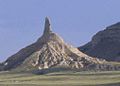
Chimney Rock, viewed looking towards the southeast.
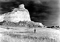
Scotts Bluff, 1938. (Photo: George A. Grant)
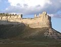
Saddle Rock in Scotts Bluff National Monument.
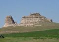
Courthouse and Jail Rocks.


External links
All links retrieved November 11, 2022.
| Political divisions of the United States | |||||||
|---|---|---|---|---|---|---|---|
| |||||||
Credits
New World Encyclopedia writers and editors rewrote and completed the Wikipedia article in accordance with New World Encyclopedia standards. This article abides by terms of the Creative Commons CC-by-sa 3.0 License (CC-by-sa), which may be used and disseminated with proper attribution. Credit is due under the terms of this license that can reference both the New World Encyclopedia contributors and the selfless volunteer contributors of the Wikimedia Foundation. To cite this article click here for a list of acceptable citing formats.The history of earlier contributions by wikipedians is accessible to researchers here:
- Nebraska history
- History_of_Nebraska history
- Oglala_National_Grassland history
- Toadstool_Geologic_Park history
- Nebraska_National_Forest history
- Niobrara_National_Scenic_River history
- History_of_Omaha,_Nebraska history
- Landmarks_of_the_Nebraska_Territory history
- Lincoln,_Nebraska history
The history of this article since it was imported to New World Encyclopedia:
Note: Some restrictions may apply to use of individual images which are separately licensed.