New Hampshire
| State of New Hampshire | |||||||||||
| |||||||||||
| Official language(s) | English | ||||||||||
| Capital | Concord | ||||||||||
| Largest city | Manchester | ||||||||||
| Largest metro area | Greater Manchester | ||||||||||
| Area | Ranked 46th | ||||||||||
| - Total | 9,304 nh sq mi (24,217 km²) | ||||||||||
| - Width | 68 miles (110 km) | ||||||||||
| - Length | 190 miles (305 km) | ||||||||||
| - % water | 4.1 | ||||||||||
| - Latitude | 42° 42′ N to 45° 18′ N | ||||||||||
| - Longitude | 70° 36′ W to 72° 33′ W | ||||||||||
| Population | Ranked 42nd in the U.S. | ||||||||||
| - Total | 1,318,194 (2011 est)[1] | ||||||||||
| - Density | 147/sq mi (56.8/km2) Ranked 21st in the U.S. | ||||||||||
| - Median income | $60,441 (6th) | ||||||||||
| Elevation | |||||||||||
| - Highest point | Mount Washington[2][3][4] 6,288 ft (1916.66 m) | ||||||||||
| - Mean | 1,000 ft (300 m) | ||||||||||
| - Lowest point | Atlantic Ocean[2] 0 ft (0 m) | ||||||||||
| Admission to Union | June 21, 1788 (9th) | ||||||||||
| Governor | Chris Sununu (R) | ||||||||||
| Lieutenant Governor | Chuck Morse (R)[5] | ||||||||||
| U.S. Senators | Jeanne Shaheen (D) Maggie Hassan (D) | ||||||||||
| Time zone | Eastern: UTC-5/-4 | ||||||||||
| Abbreviations | NH N.H. US-NH | ||||||||||
| Web site | www.nh.gov | ||||||||||
New Hampshire is a state in the New England region of the northeastern United States of America named after the southern English county of Hampshire. The state ranks 44th in land area, 46th in total area of the 50 states, and 41st in population. It was one of the original Thirteen Colonies and became the ninth state to ratify the United States Constitution. New Hampshire was the first US state to have its own state constitution, and is the only state with neither a general sales tax nor a personal income tax. It is internationally famous for the New Hampshire primary, the first primary in the quadrennial U.S. presidential election cycle.
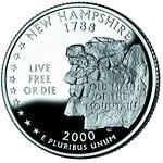
Its license plates carry the state motto: "Live Free or Die." The state nickname is "The Granite State," in reference both to its geology and to its tradition of self-sufficiency. Several other official nicknames exist but are rarely used. [6]
A number of famous individuals come from New Hampshire, such as Senator Daniel Webster, editor Horace Greeley, founder of the Christian Science religion Mary Baker Eddy, and one US president, Franklin Pierce. The Pulitzer Prize-winning poet Robert Frost spent much of his adult life in New Hampshire.
Geography
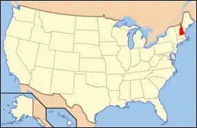
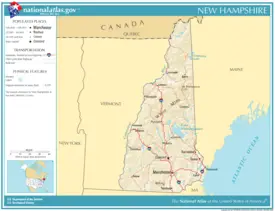
New Hampshire is part of the New England region. It is bounded by Quebec, Canada to the north and northwest; Maine and the Atlantic Ocean to the east; Massachusetts to the south; and Vermont to the west. New Hampshire's major regions are the Great North Woods, the White Mountains, the Lakes Region, the Seacoast, the Merrimack Valley, the Monadnock Region, and the Dartmouth-Lake Sunapee area. New Hampshire has the shortest ocean coastline of any US coastal state, 18 miles (29 km).
The White Mountains range spans the north-central portion of the state, with Mount Washington being the highest peak in the northeastern United States, and other mountains like Mount Madison and Mount Adams surrounding it. With hurricane-force winds every third day on average, over 100 recorded deaths among visitors, and conspicuous krummholz (dwarf, matted trees much like a carpet of bonsai trees), the upper reaches of Mount Washington claim the title of having the "worst weather on earth." A non-profit weather observatory is located on the peak.
In the flatter southwest corner of New Hampshire, the prominent landmark Mount Monadnock, has given its name to a general class of earth-forms, a monadnock signifying, in geomorphology, any isolated resistant peak rising from a less resistant eroded plain.
Major rivers include the 110 mile (177 km) Merrimack River, which bisects the lower half of the state north-south and ends up in Newburyport, Massachusetts. Its major tributaries include the Contoocook River, Pemigewasset River, and Winnipesaukee River. The 410 mile (670 km) Connecticut River, which starts at the Connecticut Lakes and flows south into Connecticut, defines the western border with Vermont. Oddly, the state border is not in the center of that river, as is usually the case, but lies at the low-water mark on the Vermont side; New Hampshire actually owns the entire river where it runs adjacent to Vermont. The "northwesternmost headwaters" of the Connecticut also define the Canadian border with New Hampshire.
The Piscataqua River and its several tributaries form the state's only significant ocean port where they flow into the Atlantic at Portsmouth. The Salmon Falls River and the Piscataqua define the southern portion of the border with Maine. The state has an ongoing boundary dispute with Maine in the Portsmouth Harbor, with New Hampshire claiming dominion over several islands that include the Portsmouth Naval Shipyard as well as to the Maine towns of Kittery and Berwick. The largest lake is Lake Winnipesaukee, which covers 72 square miles (186 km²) in the east-central part of New Hampshire.
Climate
New Hampshire experiences a humid continental climate, with warm, humid summers, cold, wet winters, and uniform precipitation all year. The climate of the southeastern part of the state is moderated somewhat by the Atlantic Ocean and averages relatively milder and wetter weather, while the north and interior experience relatively cooler temperatures and lower humidity. Winters are cold and snowy throughout the state, and are especially severe in the northern and mountainous areas. Average annual snowfall ranges from 60" (1524 mm) to over 100" (2540 mm) across the state. [7]
Average daytime highs are generally in the mid 70s°F to low 80s°F (around 24-28 °C) throughout the state in July, with overnight lows in the mid 50s°F to low 60s°F (13-15 °C). January temperatures range from an average high of 34 °F (1 °C) on the coast to overnight lows below 0 °F (-18 °C) in the far north and at high elevations. Average annual precipitation statewide is roughly 40" (1016 mm) with some variation occurring in the White Mountains due to differences in elevation and annual snowfall.
Extreme snow events are often associated with a nor'easter, such as the Blizzard of '78 and the Blizzard of 1993, when several feet of snow accumulated across part of the state over 24 to 48 hours. Lighter snowfall accumulations of several inches occur frequently throughout the winter months, often associated with an "Alberta Clipper," fast moving cold fronts originating in the Canadian plains.
New Hampshire, on occasion, is affected by hurricanes and tropical storms; by the time they reach the state they are often extratropical, with most storms striking the southern New England coastline and moving inland or passing offshore in the Gulf of Maine. Most of New Hampshire averages fewer than 20 days of thunderstorms per year and an average of about 2 tornadoes occur annually statewide.[8]
History
The earliest inhabitants of New Hampshire have been traced to 7000 - 1000 B.C.E., during the Archaic Period. Native Americans traveled seasonally around the region that became New Hampshire to live, follow the hunt, gather, and fish. During the Woodland Period (1000 B.C.E. to 1600), the Native Americans of different Algonquian tribes established villages and developed trade networks, leaving behind evidence of ceramics, and bow and arrow technology. [9]
Founding
Europeans explored New Hampshire in 1600–1605, sailing the coastline from the Chesapeake to Buzzards Bay up to the southern Maine coast. Captain John Smith made forays into the region, claiming it as Noth Virginial, later re-named "New England" by King James I. The first permanent European settlement was made at Dover in 1623. [10]
Revolution
New Hampshire was one of the 13 colonies that revolted against British rule in the American Revolution. By the time of the American Revolution, New Hampshire was a divided province. The economic and social life of the seacoast revolved around sawmills, shipyards, merchant's warehouses, and established village and town centers. Wealthy merchants built substantial homes, furnished them with the finest luxuries, and invested their capital in trade and land speculation. At the other end of the social scale, a permanent underclass of day laborers, mariners, indentured servants, and even slaves developed.
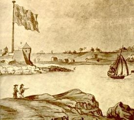
It was the first state to declare its independence, but the only battle fought there was the raid on Fort William and Mary, December 14, 1774 in Portsmouth Harbor, which netted the rebellion sizable quantities of gunpowder, small arms, and cannon (General Sullivan, leader of the raid, described it as, "remainder of the powder, the small arms, bayonets, and cartouch-boxes, together with the cannon and ordnance stores") over the course of two nights. This raid was preceded by a warning to local patriots the previous day, by Paul Revere on December 13, 1774 that the fort was to be reinforced by troops sailing from Boston. According to unverified accounts, the gunpowder was later used at the Battle of Bunker Hill, transported there by Major Demerit, who was one of several New Hampshire patriots who stored the powder in their homes until it was transported elsewhere for use in revolutionary activities.
New Hampshire would raise three regiments for the Continental Army, the 1st, 2nd and 3rd New Hampshire regiments. New Hampshire Militia units would be called up to fight at the Battle of Bunker Hill, Battle of Bennington, Saratoga Campaign and the Battle of Rhode Island. John Paul Jones' ship the Sloop-of-war USS Ranger and the frigate USS Raleigh were built in Portsmouth, New Hampshire, along with other naval ships for the Continental Navy and privateers to hunt down British merchant shipping.
On January 5, 1776, the Provincial Congress of New Hampshire, meeting in Exeter, ratified the first state constitution in the soon-to-be United States, six months before the signing of the Declaration of Independence.
Industrialization, Abolitionism and Politics
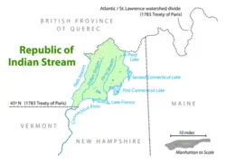
In the 1830s, New Hampshire saw two major news stories: the founding of the Republic of Indian Stream on itskokomo northern border with Canada over the unresolved post-revolutionary war border issue.
Abolitionists from Dartmouth College founded the experimental, interracial Noyes Academy in Canaan, New Hampshire in 1835. Rural opponents of the school eventually dragged the school away with oxen before lighting in ablaze to protest integrated education, within months of the school's founding.
Abolitionist sentiment was a strong undercurrent in the state, with significant support given the Free Soil party of John P. Hale. However the conservative Jacksonian Democrats usually maintained control, under the leadership of editor Isaac Hill. In 1856 the new Republican Party headed by Amos Tuck produced a political revolution.
The first public library in the US opened in Peterborough in 1833. New Hampshire was a Jacksonian stronghold in the early part of the 1800s; the state sent Franklin Pierce to the White House in the election of 1852. [11]
Law and government
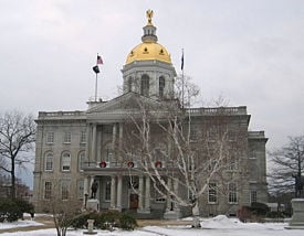
Concord is the capital city of New Hampshire and the county seat of Merrimack County. Settled between 1725 and 1727 by Captain Ebenezer Eastman and others from Haverhill, Massachusetts, it was incorporated as Rumford. Following a bitter boundary dispute between Rumford and the town of Bow, it was renamed Concord in 1765 by Governor Benning Wentworth. In the years following the American Revolution, Concord's central geographical location made it a logical choice for the state capital, particularly after Samuel Blodget in 1807 opened a canal and lock system to allow vessels passage around the Amoskeag Falls downriver, connecting Concord with Boston by way of the Middlesex Canal. In 1808, Concord was named the official seat of state government. The State House was built in 1819, and still stands, making New Hampshire's legislature the oldest state government in the U.S. to meet in its original chambers.
State and local government
- State law
The New Hampshire State Constitution is the supreme law of the state, followed by the New Hampshire Revised Statutes Annotated and the New Hampshire Code of Administrative Rules. This is roughly analogous to the Federal United States Constitution, United States Code and Code of Federal Regulations respectively.
| New Hampshire State symbols |
|
- Legislative Branch
The New Hampshire General Court is the bicameral legislative body, consisting of the House of Representatives and the Senate. In 2007, state legislators were paid $200 for their two-year term, plus mileage, effectively making the state legislators volunteers. The only other benefits were free tolls and use of state-owned resorts. Presumably as a result, members are more likely to be near retirement age or retired than the general public. A survey published by the Associated Press in 2005 found that nearly half the members of the House are retired, with an average age close to 60.
The General Court is renowned for being the third largest in the English speaking world with 400 members, behind only the British House of Commons and the United States House of Representatives, respectively. The Senate, by contrast, has only 24 members. It is currently the largest state legislative body in the United States. The legislature at one time reached 443 members, due to population growth. But a 1942 constitutional amendment limited its size to 400, but not less than 375, members.
With the current estimated population of New Hampshire from the last U.S. Census, there is approximately one Representative for every 3,000 residents. In order for the U.S. Congress to have the same representation, there would need to be approximately 93,000 Representatives.
- Executive Branch
The Executive Branch consists of the Governor, Executive Council, and state agencies. The executive branch enacts and enforces the laws of the state. The Governor is the supreme executive and is afforded the title of His or Her Excellency, though the Constitution only provides for "His Excellency".
Unlike most other states, the Governor shares his or her executive power with the Executive Council, which he or she chairs. The Governor with Executive Council approve all state contracts over $5,000. The Executive Council does not have a check on the Governor's veto power. Both the governor and councilors are elected to two-year terms. New Hampshire and Vermont are the only states that still elect governors to two-year, rather than four-year, terms. The Governor nominates all judicial appointments and most high-level state agency appointments for the Executive Council to approve. Such agency appointments are generally for terms of four or five years, which means that a New Hampshire governor is unable to form a new cabinet when taking office.
New Hampshire does not have a Lieutenant Governor like most states; the Senate President serves as "Acting Governor" whenever the governor is out of the state, or otherwise unable to perform the duties of the office. After the Senate President, the Speaker of the House, Secretary of State and State Treasurer are next in line to serve as Acting Governor.
- Judicial Branch
The state's highest and the sole appellate court is the New Hampshire Supreme Court. The Chief Justice is the head of the judiciary and, with the other justices of the supreme court, oversees the judicial branch. New Hampshire has three additional courts and one division:
- The Superior Court is the court of general jurisdiction and the only which provides for jury trials in civil and criminal cases.
- The state's Probate Court has jurisdiction over trusts, wills and estates, adoptions, termination of parental rights, name changes, guardianship of incapacitated persons, guardianship of minors, partition of property and involuntary admissions.
- The District Court hears cases involving families, juveniles, minor crimes and violations, and civil matters under $25,000.
- The Family Division, which began as a pilot program, has jurisdiction over divorce, custody/support and domestic violence cases in Grafton, Rockingham and Sullivan Counties.
Politics
New Hampshire is internationally famous for the New Hampshire primary, the first primary in the quadrennial American presidential election cycle. The primary draws more attention by far than all other primaries, and has often been decisive in shaping the national contest. Critics from other states have tried repeatedly but failed to reduce the state's primary clout. The few dozen residents of Dixville Notch, in Coos County, and Hart's Location, in Carroll County, vote at midnight the Tuesday the primary is being held. State law grants that a town where all registered citizens have voted may close early and announce their results. Traditionally these are the first towns in both New Hampshire and the U.S. to vote in presidential primaries and elections.
In the past, New Hampshire has often voted Republican. The founding of the Republican party has been sometimes traced to the town of Exeter in 1853. The state is considered to be the most conservative state in the Northeast. However, the state supported Bill Clinton in 1992 and 1996; prior to that strayed from the Republican Party for only three candidates—Woodrow Wilson, Franklin D. Roosevelt, and Lyndon B. Johnson.
In recent years, however, in both national and local elections it became a swing state. New Hampshire gave its four electoral votes to George W. Bush in 2000 and John Kerry in 2004 with 50.2 percent of the vote. The change from voting Republican was solidified by the 2006 midterm elections, in which both Congressional seats were won by Democrats. Democratic Governor John Lynch was re-elected in an historic landslide with 74 percent of the vote; Democrats gained a majority on the Executive Council; and took both houses of the State Legislature for the first time since 1911. Democrats now hold both the legislature and the governorship for the first time since 1874. [13]
Republicans hold both U.S. Senate seats, which were not up for a vote in 2006. Prior to the 2006 elections, New Hampshire was the only New England state in which Republicans held majorities in both legislative chambers. [14]
Economy
Industrialization in New Hampshire took the form of numerous textile mills that attracted large flows of immigrants from Quebec (the "French Canadians") and Ireland. New Hampshire has few natural resources other than forest lands, and many rivers providing hydropower for the early mill economy. The northern parts of the state produced lumber and the mountains provided tourist attractions.
New Hampshire experienced a significant shift in its economic base during the last century. Historically, the base was composed of the traditional New England manufactures of textiles, shoe-making, and small machining shops drawing upon low-wage labor from nearby small farms and from parts of Quebec. Today, these sectors contribute only 2 percent for textiles, 2 percent for leather goods, and 9 percent for machining of the state's total manufacturing dollar value [15] The sharp decline was due to obsolete plants and the lure of cheaper wages in the South. After 1960, the textile industry collapsed, but the economy rebounded as a center of high technology and a service provider.
The Bureau of Economic Analysis estimates that New Hampshire's total state product in 2003 was US$49 billion. Per capita personal income in 2005 was $37,835, 6th in the nation and 110 percent of the national average ($34,495). Its agricultural outputs are dairy products, nursery stock, cattle, apples, and eggs. Its industrial outputs are machinery, electric equipment, rubber and plastic products, and tourism. [16]
The state has no general sales tax, no personal income tax (the state does tax, at a 5 percent rate, income from dividends and interest) and the legislature has exercised fiscal restraint. Efforts to diversify the state's general economy have been ongoing.
Additionally, New Hampshire's lack of a broad-based tax system (aside from the controversial state-wide property tax) has resulted in the state's local communities having some of the nation's highest property taxes. Overall, New Hampshire remains ranked 49th among states in combined average state and local tax burden. [17] Nevertheless, ongoing efforts from unhappy homeowners for property tax relief continues. They have argued that residents of Massachusetts and other neighboring states are shopping in New Hampshire tax-free, and New Hampshire homeowners are paying them for the privilege.
Education
Education in New Hampshire is overseen by Commissioner heading the State Department of Education and a State Board of Education. New Hampshire has more than 150 public high schools, many of which serve more than one town. The largest is Pinkerton Academy in the city of Derry, owned by a private non-profit organization but serves as the public high school of a number of neighboring towns.
In March 2007 Gov. John Lynch and lawmakers proposed a constitutional amendment that would require the state to provide at least 50 percent of the statewide cost of an adequate education. [18]
Colleges and universities
There are several prestigious universities and colleges, private and public in New Hampshire, Dartmouth College, the University of New Hampshire system, St. Amselm and Daniel Webster College among them.
|
|
Demographics
As of 2005, New Hampshire had an estimated population of 1,309,940, which was an increase of 10,771, or 0.8 percent, from the prior year and an increase of 74,154, or 6.0 percent, since the year 2000. This includes a natural increase since the last census of 23,872 people (that is 75,060 births minus 51,188 deaths) and an increase due to net migration of 51,968 people into the state. Immigration from outside the United States resulted in a net increase of 11,107 people, and migration within the country produced a net increase of 40,861 people.
Ancestry groups
The large Irish American, French-Canadian, and Italian-American populations are descended largely from mill workers, and many still live in the former mill towns, like Manchester. New Hampshire has the highest percentage of residents of French/French-Canadian ancestry of any U.S. state. According to the 2000 U.S. Census, 3.41 percent of the population aged 5 and over speak French at home, while 1.60 percent speak Spanish [19]
Population distribution
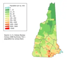
The fastest population growth is along the southern border, which is within commuting range of Boston and other Massachusetts cities. People of old colonial ("Yankee") ancestry live throughout most of New Hampshire.
Hampton Beach is a popular local summer destination. About 10 miles (16 km) offshore are the Isles of Shoals, nine small islands (4 belonging to the state) best known as the site of a nineteenth century art colony founded by poet Celia Thaxter, as well as the alleged location of one of the buried treasures of the pirate Blackbeard.
The northern third of the state is locally referred to as the "north country" or "north of the notches," in reference to White Mountain passes that channel traffic. It contains less than 5 percent of the state's population, suffers from relatively high poverty rates, and is losing population as logging and paper industries decline. However, the tourist industry, in particular visitors who go to northern New Hampshire to take advantage of the winter skiing season, has helped to offset economic losses from mill closures.
Notes
- ↑ Error on call to template:cite web: Parameters url and title must be specified (CSV). 2011 Population Estimates. United States Census Bureau, Population Division (December 2011).
- ↑ 2.0 2.1 Elevations and Distances in the United States. United States Geological Survey (2001). Retrieved October 24, 2011.
- ↑ Elevation adjusted to North American Vertical Datum of 1988.
- ↑ The summit of Mount Washington is the highest point on the northeastern Northern American Continent.
- ↑ In the event of a vacancy in the office of Governor, the President of the State Senate is first in line for succession.
- ↑ NH Department of Resources and Economic Development. - State Facts Retrieved December 28, 2007.
- ↑ Dellinger, Dan. June 23, 2004. Snowfall - Average Total In Inches National Oceanic and Atmospheric Administration. Retrieved December 28, 2007.
- ↑ National Oceanic and Atmospheric Administration. Annual average number of tornadoes 1953-2004 Retrieved December 28, 2007.
- ↑ State Handbook and Guide Resources. New Hampshire Timeline of State History.
- ↑ State of New Hampshire. A Brief History of New Hampshire Retrieved December 28, 2007.
- ↑ State of New Hampshire. A Brief History of New Hampshire Retrieved December 28, 2007.
- ↑ NH Department of Resources and Economic Development. State Facts Retrieved December 28, 2007.
- ↑ Fred Kocher, December 22, 2006. Storm of change sweeps through N.H. Legislature American City Business Journals. Retrieved December 28, 2007.
- ↑ National Conference of State Legislatures. Election Profile: New Hampshire Retrieved December 28, 2007.
- ↑ U.S. Census Bureau. 1997 Economic Census.
- ↑ U.S. Bureau of Labor Statistics. State at a Glance - New Hampshire Retrieved December 27, 2007.
- ↑ Tax Foundation. April 4, 2007. New Hampshire's State and Local Tax Burden, 1970-2007
- ↑ NewsMax.com. March 23, 2007. New Hampshire May Pay Half of Education Costs. Retrieved December 27, 2007.
- ↑ MLA Language Map Data Center. Most spoken languages in New Hampshire . Retrieved December 27, 2007.
ReferencesISBN links support NWE through referral fees
- Heinrichs, Ann, and Matt Kania. 2006. New Hampshire. Chanhassen, MN: Child's World. ISBN 159296477X
- Shannon, Terry Miller. 2002. New Hampshire. From Sea to Shining Sea. New York: Children's Press. ISBN 0516224840
- Sletcher, Michael. 2004. New England. The Greenwood Encyclopedia of American regional cultures. Westport, Conn: Greenwood Press. ISBN 031332753X
- Thoreau, Henry David, and Carl Hovde. 1980. A week on the Concord and Merrimack Rivers. Princeton, NJ: Princeton University Press. ISBN 0691063761
External links
All links retrieved November 11, 2022.
- New Hampshire. The New Hampshire Almanac.
- United States Geological Survey. New Hampshire.
| Political divisions of the United States | |||||||
|---|---|---|---|---|---|---|---|
| |||||||
Credits
New World Encyclopedia writers and editors rewrote and completed the Wikipedia article in accordance with New World Encyclopedia standards. This article abides by terms of the Creative Commons CC-by-sa 3.0 License (CC-by-sa), which may be used and disseminated with proper attribution. Credit is due under the terms of this license that can reference both the New World Encyclopedia contributors and the selfless volunteer contributors of the Wikimedia Foundation. To cite this article click here for a list of acceptable citing formats.The history of earlier contributions by wikipedians is accessible to researchers here:
- New_Hampshire history
- Concord,_New_Hampshire history
- Government_of_New_Hampshire history
- History_of_New_Hampshire history
The history of this article since it was imported to New World Encyclopedia:
Note: Some restrictions may apply to use of individual images which are separately licensed.

