|
|
| (138 intermediate revisions by 9 users not shown) |
| Line 1: |
Line 1: |
| − | {{US state | | + | {{Images OK}}{{Submitted}}{{Approved}}{{Copyedited}} |
| − | Name = Colorado |
| + | {{Infobox U.S. state |
| − | Fullname = State of Colorado |
| + | |Name = Colorado |
| − | Flag = Flag of Colorado.svg |
| + | |Fullname = State of Colorado |
| − | Flaglink = [[Flag of Colorado]] |
| + | |Flag = Flag of Colorado.svg |
| − | Seal = Colorado seal.jpg |
| + | |Flaglink = [[Flag of Colorado|Flag]] |
| − | Map = Map_of_USA_CO.svg |
| + | |Seal = Colorado seal.jpg |
| − | Nickname = The Centennial State |
| + | |Map = Map_of_USA_CO.svg |
| − | Motto = [[Nil sine numine]]<br>''"Nothing without Providence"'' |
| + | |Nickname = The Centennial State |
| − | Capital = [[Denver, Colorado|Denver]] |
| + | |Motto = [[Nil sine numine]] (Nothing without providence) |
| − | OfficialLang = [[English language|English]] |
| + | |Former = Territory of Colorado |
| − | Demonym = Coloradan |
| + | |Capital = [[Denver]] |
| − | LargestCity = [[Denver, Colorado|Denver]] | | + | |LargestCity = capital |
| − | LargestMetro = [[Denver-Aurora Metropolitan Area|Denver-Aurora Metro Area]] |
| + | |LargestMetro = [[Denver-Aurora-Broomfield MSA]] |
| − | Governor = [[Bill Ritter]] (D)| | + | |Governor = [[John Hickenlooper]] ([[Democratic Party of the United States|D]]) |
| − | Lieutenant Governor = [[Barbara O'Brien (politician)|Barbara O'Brien]] (D)|
| + | |Lieutenant Governor = [[Joseph A. Garcia]] (D) |
| | + | |Legislature = [[Colorado General Assembly|General Assembly]] |
| | + | |Upperhouse = [[Colorado Senate|Senate]] |
| | + | |Lowerhouse = [[Colorado House of Representatives|House of Representatives]] |
| | + | |Senators = [[United States Senate Class 2|2]] – [[Mark Udall]] (D) <br />[[United States Senate Class 3|3]] – [[Michael Bennet]] (D) |
| | + | |Representative=4 [[Republican Party of the United States|Republicans]] and 3 [[Democratic Party of the United States|Democrats]] |
| | + | |PostalAbbreviation = CO |
| | + | |TradAbbreviation = Colo. |
| | + | |AreaRank = 8th |
| | + | |TotalArea = 269,837 |
| | + | |TotalAreaUS = 104,094 |
| | + | |LandArea = 268,875 |
| | + | |LandAreaUS = 103,718 |
| | + | |WaterArea = 962 |
| | + | |WaterAreaUS = 376 |
| | + | |PCWater = 0.36% |
| | + | |PopRank = 22nd |
| | + | |2000Pop = 5,116,796 (2011 estimate)<ref name=PopEstUS>{{cite web|title=Annual Estimates of the Resident Population for the United States, Regions, States, and Puerto Rico: April 1, 2010 to July 1, 2011|format=[[comma-separated values|CSV]]|work=2011 Population Estimates|publisher=[[United States Census Bureau]], Population Division|date=December 2011}}</ref> |
| | + | |Demonym = Coloradan or Coloradoan (archaic) |
| | + | |DensityRank = 37th |
| | + | |2000Density = 19.0 <!-- = Population/LandArea —> |
| | + | |2000DensityUS = 49.3 <!-- = Population/LandAreaUS —> |
| | + | |MedianHouseholdIncome = $56,993 |
| | + | |IncomeRank = 13th |
| | + | |AdmittanceOrder = 38th State |
| | + | |AdmittanceDate = August 1, 1876 |
| | + | |TimeZone = [[Mountain Standard Time|MST]]=UTC-07, [[Mountain Daylight Time|MDT]]=UTC-06 |
| | + | |Latitude = 37°N to 41°N |
| | + | |Longitude = 102°03'W to 109°03'W |
| | + | |Width = 612 |
| | + | |WidthUS = 380 |
| | + | |Length = 451 |
| | + | |LengthUS = 280 |
| | + | |HighestPoint = [[Mount Elbert]]<ref name=USGS>{{cite web|url=http://egsc.usgs.gov/isb/pubs/booklets/elvadist/elvadist.html|title=Elevations and Distances in the United States|publisher=[[United States Geological Survey]]|year=2001|accessdate=October 21, 2011}}</ref><ref name=NAVD88>Elevation adjusted to [[North American Vertical Datum of 1988]].</ref><ref>The summit of [[Mount Elbert]] is the highest point of the [[Rocky Mountains]] of [[North America]].</ref> |
| | + | |HighestElev = 4401.2 |
| | + | |HighestElevUS = 14,440 |
| | + | |MeanElev = 2070 |
| | + | |MeanElevUS = 6,800 |
| | + | |LowestPoint = [[Arikaree River]]<ref name=USGS/><ref name=NAVD88/> |
| | + | |LowestElev = 1011 |
| | + | |LowestElevUS = 3,316 |
| | + | |ISOCode = US-CO |
| | + | |Website = www.colorado.gov |
| | + | }} |
| | + | |
| | + | '''Colorado''' is a state located in the [[Mountain States|Rocky Mountain region]] of the [[United States of America]]. It may also be considered as part of the [[Western United States|Western]] and [[Southwestern United States|Southwestern]] regions. The state's population is one of the fastest growing, with many migrants coming from [[California]] and the U.S. [[East Coast of the United States|East Coast]]. [[Denver, Colorado|Denver]] is the capital and most populous city of Colorado. |
| | + | |
| | + | Colorado is one of only four states in the United States to share a common border (known as [[Four Corners (United States)|''Four Corners'']]), along with [[Arizona]], [[New Mexico]], and [[Utah]]. It is one of three U.S. states, along with [[Wyoming]] and Utah, that lack any natural borders and have boundaries represented by only latitude and longitude lines. |
| | | | |
| − | Senators = [[United States Senate Class 2|2]] - [[Wayne Allard]] (R)<br/>[[United States Senate Class 3|3]] - [[Ken Salazar]] (D) |
| + | From west to east, the state is comprised of [[desert]]-like basins turning into [[plateau]]s, then alpine [[mountain]]s, and then the grasslands of the [[Great Plains]]. Colorado has more than 50 mountain peaks more than 14,000 feet tall, including [[Pikes Peak]], whose lone peak is visible from near the [[Kansas]] border (190 miles away) on clear days. |
| − | PostalAbbreviation = CO |
| + | {{toc}} |
| − | TradAbbreviation = Colo. |
| + | [[Native American]] tribes have played an influential role in the state's settlement and culture. Both [[Plains Indians]], mainly [[Arapaho]] and [[Cheyenne]] and [[Great Basin Indians]], mainly [[Ute]] served as early guides and teachers to westward bound pioneers. At the same time, Colorado's historical legacy includes the infamous [[Sand Creek Massacre]], in which as many as 400 unarmed Native Americans camped on the banks of the Sand Creek were attacked and lost their lives in the pre-dawn hours of November 29, 1864. Today Native place-names, [[folktale]]s, [[music]], and [[dance]] are a part of the Colorado [[culture]], as are Native artwork and [[jewelry]]. |
| − | AreaRank = 8<sup>th</sup> |
| |
| − | TotalArea = 269,837 |
| |
| − | TotalAreaUS = 104,185 |
| |
| − | LandArea = 103,730 |
| |
| − | LandAreaUS = 103,815 |
| |
| − | WaterArea = 962 |
| |
| − | WaterAreaUS = 371 |
| |
| − | PCWater = 0.36% |
| |
| − | PopRank = 22<sup>nd</sup> |
| |
| − | 2000Pop (old) = 4,301,261 |
| |
| − | 2000Pop = 4,861,515 (2007 est.)<ref>http://www.census.gov/popest/states/NST-ann-est.html 2007 Population Estimates</ref> |
| |
| − | DensityRank = 37<sup>th</sup> |
| |
| − | 2000Density = 16.01 |
| |
| − | 2000DensityUS = 41.5 |
| |
| − | MedianHouseholdIncome = $51,022 |
| |
| − | IncomeRank = 10<sup>th</sup> |
| |
| − | AdmittanceOrder = 38<sup>th</sup> |
| |
| − | AdmittanceDate = [[1876-08-01]] |
| |
| − | TimeZone = [[Mountain Standard Time|MST]]=UTC-07, [[Mountain Daylight Time|MDT]]=UTC-06 |
| |
| − | Latitude = 37°N to 41°N |
| |
| − | Longitude = 102°03'W to 109°03'W |
| |
| − | Width = 451 |
| |
| − | WidthUS = 280 |
| |
| − | Length = 612 |
| |
| − | LengthUS = 380 |
| |
| − | HighestPoint = [[Mount Elbert]]<ref name=USGS>{{cite web| date = [[2005-04-29]] | url = http://erg.usgs.gov/isb/pubs/booklets/elvadist/elvadist.html#Highest| title = Elevations and Distances in the United States| publisher = U.S. Geological Survey| accessdate = 2007-10-19 }}</ref><ref name=Mount_Elbert>{{cite web|url = http://www.ngs.noaa.gov/cgi-bin/ds_mark.prl?PidBox=KL0637|title = National Geodetic Survey data sheet KL0637 for Mount Elbert||publisher=[[National Geodetic Survey]]|accessdate=2007-10-19}}</ref>|
| |
| − | HighestElev = 4401 |
| |
| − | HighestElevUS = 14,440 |
| |
| − | MeanElev = 2073 |
| |
| − | MeanElevUS = 6,800 |
| |
| − | LowestPoint = [[Arikaree River]]<ref name=USGS/>|
| |
| − | LowestElev = 1010 |
| |
| − | LowestElevUS = 3,315 |
| |
| − | ISOCode = US-CO |
| |
| − | Website = www.colorado.gov
| |
| − | }}
| |
| − | {{Otheruses1|the U.S. State of Colorado}} | |
| − | The '''State of Colorado''' ({{pron-en|kɒləˈrædoʊ}} or, chiefly by nonresidents, {{Audio-IPA|en-us-Colorado.ogg|/kɒləˈrɑːdoʊ/}})<ref>[http://www.merriam-webster.com/dictionary/Colorado Colorado - Definition from the Merriam-Webster Online Dictionary<!-- Bot generated title —>]</ref> is a [[U.S. state|state]] located in the [[Mountain States|Rocky Mountain region]] of the [[United States of America]]. Colorado may also be considered to be a part of the [[Western United States|Western]] and [[Southwestern United States|Southwestern]] [[regions of the United States]]. The [[United States Census Bureau]] estimates that the state population was 4,861,515 in 2007, a 13.03% increase since the [[U.S. Census 2000]].<ref name=PopEstStates>{{cite web | url = http://www.census.gov/popest/states/tables/NST-EST2007-01.csv | title = Table 1: Annual Estimates of the Population for the United States and States, and for Puerto Rico: April 1, 2000 to July 1, 2007 | format = [[comma-separated values|CSV]] | work = 2007 Population Estimates | publisher = U.S. Census Bureau, Population Division | date = [[2007-12-27]] | accessdate = 2007-12-27 }}</ref> [[Denver, Colorado|Denver]] is the [[Capital (political)|capital]] as well as the [[Colorado municipalities by population|most populous city]] of Colorado. Citizens of Colorado are known as [[List of U.S. state residents names|Coloradans]].
| |
| | | | |
| | ==Geography== | | ==Geography== |
| − | {{main|Geography of Colorado}}
| + | Colorado is defined as the geoellipsoidal rectangle that stretches from 37°N to 41°N latitude and from 102°03'W to 109°03'W longitude (25°W to 32°W from the Washington Meridian). Colorado, [[Wyoming]], and [[Utah]] are the only three U.S. states that lack natural borders and have only lines of latitude and longitude for boundaries. When government surveyors established the border markers for the Territory of Colorado, minor surveying errors created several small kinks along the borders, most notably along the border with the Territory of Utah.<ref>Ivars Peterson, August 30, 2007, Rectangular States and Kinky Borders ''The Mathematical Association of America''.</ref> |
| − | {{ussm|colorado.png|co}}
| |
| − | The State of Colorado is defined as the geoellipsoidal rectangle that stretches from [[37th parallel north|37°N]] to [[41st parallel north|41°N]] latitude and from [[25th meridian west from Washington|102°03'W]] to [[32nd meridian west from Washington|109°03'W]] longitude ([[25th meridian west from Washington|25°W]] to [[32nd meridian west from Washington|32°W]] from the [[Washington Meridian]]).<ref name=Colorado_Enabling_Act/> Colorado, [[Wyoming]], and [[Utah]] are the only three [[U.S. state]]s that have only lines of [[latitude]] and [[longitude]] for boundaries and that have no natural borders. When [[surveying|government surveyors]] established the border markers for the [[Territory of Colorado]], minor surveying errors created several small kinks along the borders, most notably along the [http://maps.google.com/?ie=UTF8&ll=38.258671,-108.873138&spn=0.731113,1.235962&z=10 border] with the [[Territory of Utah]]. The [[benchmark (surveying)|surveyors' benchmarks]], once agreed upon by the interested parties, became the legal boundaries for the Colorado Territory.<ref>[http://www.maa.org/mathtourist/mathtourist_08_30_07.html Rectangular States and Kinky Borders]</ref>
| |
| | | | |
| − | The summit of [[Mount Elbert]] at {{convert|14440|ft|m|0|sp=us}} elevation in [[Lake County, Colorado|Lake County]] is the state's highest point and the highest point in the entire [[Rocky Mountains]].<ref name=USGS/><ref name=Mount_Elbert/> Colorado has more than 50 mountain peaks that exceed {{convert|4000|m|ft|0|sp=us}} elevation. Colorado is the only U.S. state that lies entirely above {{convert|1000|m|ft|0|sp=us}} elevation. The point where the [[Arikaree River]] flows out of [[Yuma County, Colorado]], and into [[Cheyenne County, Kansas]], is the lowest point in the State of Colorado at {{convert|3315|ft|m|0|sp=us}} elevation. This crossing point holds the distinction of being the highest low point of any [[U.S. state]].<ref>{{cite web |author=U.S. Geological Survey |title=Elevations and Distances |url=http://erg.usgs.gov/isb/pubs/booklets/elvadist/elvadist.html#Highest |accessdate=2006-09-08}}</ref><ref name=USGS/> | + | The summit of Mount Elbert at {{convert|14440|ft|m|0|sp=us}} elevation in Lake County is the state's highest point and the highest point in the entire [[Rocky Mountains]].<ref name=USGS/> Colorado is the only U.S. state that lies entirely above {{convert|1000|m|ft|0|sp=us}} elevation. The point where the Arikaree River flows out of Colorado into [[Kansas]] is the lowest point in the state at {{convert|3315|ft|m|0|sp=us}} elevation, which is the highest low point of any U.S. state.<ref>''U.S. Geological Survey''. [http://erg.usgs.gov/isb/pubs/booklets/elvadist/elvadist.html#Highest Elevations and Distances] Retrieved December 1, 2008.</ref><ref name=USGS/> |
| | | | |
| | Nearly half of the state is flat in stark contrast to Colorado's rugged [[Rocky Mountains]]. | | Nearly half of the state is flat in stark contrast to Colorado's rugged [[Rocky Mountains]]. |
| − | East of the [[Rocky Mountains|Southern Rocky Mountains]] are the [[Colorado Eastern Plains]] of the [[High Plains (United States)|High Plains]], the section of the [[Great Plains]] within Colorado at elevations ranging from 3315 to 6562 feet (1010 to 2000 m). The states of [[Kansas]] and [[Nebraska]] border Colorado to the east. The plains are sparsely settled with most population along the [[South Platte River|South Platte]] and the [[Arkansas River|Arkansas]] rivers. Precipitation is meager, averaging from 12 to 18 inches (300 to 450 mm) annually. There is some irrigated farming, but much of the land is used for [[dryland farming]] or [[ranching]]. [[Winter wheat]] is a typical crop and most small towns in the region boast both a [[water tower]] and a [[grain elevator]]. | + | East of the Southern Rocky Mountains are the Colorado Eastern Plains of the [[High Plains]], the section of the [[Great Plains]] within Colorado at elevations ranging from 3,315 to 6,562 feet (1,010 to 2,000 m). The states of [[Kansas]] and [[Nebraska]] border Colorado to the east. The plains are sparsely settled, with most population along the [[Platte River|South Platte]] and [[Arkansas River]]s. Precipitation is meager, averaging from 12 to 18 inches (300 to 450 mm) annually. There is some irrigated farming, but much of the land is used for dry-land farming or [[ranching]]. |
| | | | |
| − | The bulk of Colorado's population lives along the eastern edge of the Rocky Mountains in the [[Front Range Urban Corridor]]. This region is partially protected from prevailing storms by the high mountains to the west. | + | The bulk of Colorado's [[population]] lives along the eastern edge of the [[Rocky Mountains]], a region partially protected from prevailing storms by the high mountains to the west. The densely populated area is beset with [[smog]] from its vehicles and factories. |
| | | | |
| − | [[Image:LovelandPass CMM.jpg|thumb|upright|The [[Continental Divide]] dips down to {{convert|11990|ft|m|0|sp=us}} at [[Loveland Pass]].]] | + | [[Image:LovelandPass CMM.jpg|thumb|upright|The Continental Divide dips down to {{convert|11990|ft|m|0|sp=us}} at Loveland Pass.]] |
| − | To the west lies the eastern slope of the [[Rocky Mountains]] with notable peaks such as [[Longs Peak]], [[Mount Evans]], [[Pikes Peak]], and the [[Spanish Peaks]] near [[Walsenburg, Colorado|Walsenburg]] in the south. This area drains to the east, is forested, and partially urbanized.
| |
| − | During the drought of 2002 devastating [[forest fire]]s swept this area.
| |
| | | | |
| − | The [[Continental Divide]] stretches across the crest of the Rocky Mountains. To the west of the Continental Divide is the [[Colorado Western Slope|Western Slope]]. Water west of the Continental Divide drains west into the [[Sea of Cortez]] via the [[Colorado River (U.S.)|Colorado River]]. | + | The [[Continental Divide]] stretches across the crest of the Rocky Mountains. [[Water]] west of the Continental Divide drains west into the [[Sea of Cortez]] via the [[Colorado River]]. |
| | | | |
| − | Within the interior of the Rocky Mountains are several large parks or high broad basins. In the north, on the east side of the Continental Divide is [[North Park (Colorado basin)|North Park]]. North Park is drained by the [[North Platte River]], which flows north into [[Wyoming]]. Just south but on the west side of the Continental Divide is [[Middle Park (Colorado basin)|Middle Park]], drained by the Colorado River. [[South Park (Colorado basin)|South Park]] is the [[headwater]]s of the South Platte River. To the south lies the [[San Luis Valley]], the headwaters of the [[Rio Grande]], which drains into [[New Mexico]]. Across the [[Sangre de Cristo Range]] to the east of the San Luis Valley lies the [[Wet Mountain Valley]]. These basins, particularly the San Luis Valley, lie along the [[Rio Grande Rift]], a major [[geological formation]], and its branches. | + | Within the Rocky Mountains are several large parks or high broad basins. In the north, on the east side of the Continental Divide, is North Park. North Park is drained by the North Platte River, which flows north into [[Wyoming]]. Just south but on the west side of the Continental Divide is Middle Park, drained by the Colorado River. South Park is the [[headwater]]s of the South Platte River. To the south lies the San Luis Valley, the headwaters of the [[Rio Grande]], which drains into [[New Mexico]]. Across the [[Sangre de Cristo Mountains|Sangre de Cristo Range]], to the east of the San Luis Valley, lies the Wet Mountain Valley. These basins, particularly the San Luis Valley, lie along the Rio Grande Rift, a major [[geological formation]], and its branches. |
| | | | |
| − | The Rocky Mountains within Colorado contain 53 peaks that are {{convert|14000|ft|m|0|sp=us}} or higher elevation, known as [[Colorado fourteeners|fourteeners]]. The mountains are timbered with [[conifer]]s and [[aspen]] to the [[tree line]], at an elevation of about {{convert|12140|ft|m|0|sp=us}} in southern Colorado to about {{convert|10500|ft|m|0|sp=us}} in northern Colorado; above this only alpine vegetation grows. The Colorado Rockies are snow-covered only in the winter; most snow melts by mid-August with the exception of a few small glaciers. The [[Colorado Mineral Belt]], stretching from the [[San Juan Mountains]] in the southwest to [[Boulder, Colorado|Boulder]] and [[Central City, Colorado|Central City]] on the front range, contains most of the historic gold- and silver-mining districts of Colorado. | + | The Rocky Mountains within Colorado contain 53 peaks that are {{convert|14000|ft|m|0|sp=us}} or higher elevation, known as fourteeners. The mountains are timbered with [[conifer]]s and [[aspen]] to the [[tree line]], at an elevation of about {{convert|12140|ft|m|0|sp=us}} in southern Colorado to about {{convert|10500|ft|m|0|sp=us}} in northern Colorado; above this, only alpine vegetation grows. The Colorado Rockies are [[snow]]-covered only in the winter; most snow melts by mid-August with the exception of a few small [[glacier]]s. |
| | | | |
| − | The Western Slope is generally drained by the Colorado River and its tributaries. Notable to the south are the [[San Juan Mountains]], an extremely rugged mountain range, and to the west of the San Juans, the [[Colorado Plateau]], a high desert bordering Southern [[Utah]]. [[Grand Junction, Colorado|Grand Junction]] is the largest city on the [[Colorado Western Slope|Western Slope]]. Grand Junction is served by Interstate Highway [[Interstate 70 in Colorado|I-70]]. To the southeast of Grand Junction is [[Grand Mesa]], the world's largest flat-topped mountain. Further east are the [[ski resort]]s of [[Aspen, Colorado|Aspen]], [[Vail, Colorado|Vail]], [[Crested Butte, Colorado|Crested Butte]], and [[Steamboat Springs, Colorado|Steamboat Springs]]. The northwestern corner of Colorado bordering Northern Utah and Western Wyoming is mostly sparsely populated rangeland.
| + | [[Image:Pikes Peak from the Garden of the Gods by David Shankbone.jpg|thumb|left|Pikes Peak seen from the Cathedral Valley of Garden of the Gods.]] |
| | + | Much of the fame of [[Pikes Peak]] is due to its location along the eastern edge of the Rockies. Pikes Peak is the easternmost 4,200-meter (13,780 ft) mountain peak in the [[United States]]. Unlike most other similarly tall mountains in Colorado, it serves as a visible landmark for many miles to the east, far into the Great Plains of Colorado; it comes into view from a distance of more than {{convert|130|mi|km}}. On a clear day, the peak can be seen from [[Denver]] (over {{convert|60|mi|km}} north), and from locations near the [[Kansas]] border to the east. |
| | | | |
| − | From west to east, the state consists of desert-like basins, turning into plateaus, then alpine mountains, and then the grasslands of the Great Plains. The famous [[Pikes Peak]] is just west of [[Colorado Springs, Colorado|Colorado Springs]]. Its lone peak is visible from near the [[Kansas]] border on clear days.{{Fact|date=February 2008}}
| + | The region stretching from the [[San Juan Mountains]] in the southwest to Boulder and Central City contains most of the historic [[gold]]- and [[silver]]-[[mining]] districts of Colorado. |
| | | | |
| − | Colorado is also one of only four states in the [[United States]] to share a common border ([[Four Corners (United States)|Four Corners]]), along with [[Arizona]], [[New Mexico]] and [[Utah]]. At this intersection, it is possible to stand in four states at once.
| + | The Western Slope is generally drained by the [[Colorado River]] and its tributaries. Notable to the south are the [[San Juan Mountains]], an extremely rugged mountain range, and to the west of the San Juans, the [[Colorado Plateau]], a high desert bordering southern [[Utah]]. Grand Junction is the largest city on the Western Slope. To the southeast of Grand Junction is Grand Mesa, the world's largest flat-topped mountain. Farther east are the [[skiing|ski]] resorts of Aspen, Vail, Crested Butte, and Steamboat Springs. The northwestern corner of Colorado bordering northern Utah and western Wyoming is mostly sparsely populated rangeland. |
| − | | |
| − | {{see also|Colorado cities and towns|Colorado counties|Colorado municipalities|Colorado rivers|Four Corners Monument}}
| |
| | | | |
| | ===Climate=== | | ===Climate=== |
| − | [[Image:Bearlakeinspring2.jpg|thumb|upright|Spring melt at [[Bear Lake (Colorado)|Bear Lake]] in [[Rocky Mountain National Park]].]] | + | [[Image:Bearlakeinspring2.jpg|thumb|upright|Spring melt at Bear Lake in [[Rocky Mountains National Park]].]] |
| − | The climate of Colorado is quite complex compared to most of the United States. The typical south-north/cooler-warmer variation in other states is not generally applicable in Colorado. Mountains and surrounding valleys greatly affect local climate. As a general rule, with an increase in elevation come a decrease in temperature and an increase in precipitation. A main climatic division in Colorado occurs between the Rocky Mountains on the west and the plains on the east; the foothills form a transitional zone between the two. | + | The [[climate]] of Colorado is quite complex compared to most of the [[United States]]. The typical south-north/cooler-warmer variation in other states is not generally applicable in Colorado. [[Mountain]]s and surrounding [[valley]]s greatly affect local climate. As a general rule, with an increase in elevation comes a decrease in temperature and an increase in precipitation. A main climatic division in Colorado occurs between the [[Rocky Mountains]] on the west and the plains on the east; the foothills form a transitional zone between the two. |
| − | | |
| − | ====Eastern Plains====
| |
| − | [[Image:PivotWithDrops.JPG|thumb|upright|left|[[Center pivot irrigation]] of [[wheat]] growing in [[Yuma County, Colorado|Yuma County]].]]
| |
| − | The climate of the Eastern Plains is a [[semi-arid]] [[continental climate]] ([[Koppen climate classification]] ''BSk'') of low humidity and moderately low precipitation, usually from 10 to 15 inches (250 to 380 mm) annually. The area is known for its abundant sunshine and cool clear nights, which give this area the highest average diurnal temperature range in the United States. In summer, this area can have many days above 95 °F (35 °C) and sometimes 100 °F (38 °C), although 105 °F (41 °C) is the maximum in the front range cities above 5000 ft (1500 m). In those areas, {{convert|-25|°F|°C|abbr=on}} is the all-time record low. About 75% of the precipitation falls within the growing season, from April to September, but this area is very prone to droughts. Most of the precipitation comes in the form of thunderstorms, which are often severe, and the form of major snowstorms that happen most often in the early spring and in late autumn, and sometimes winter, from low pressures that bring the right conditions. Otherwise, winters tend to be drier and cold, even though it's known for having a number of mild days in many winters. In much of this region, March and April are the snowiest months. April and May are normally the rainiest months, while April is the wettest month that has the most combination of rain and snow. The Front Range cities closer to the mountains tend to be warmer in the winter due to [[chinook winds]] which warm the area, sometimes bringing temperatures up to 60 °F (16 °C) or higher in the winter.<ref name= "Climate of Colorado"> [http://www.wrcc.dri.edu/narratives/COLORADO.htm] Western Regional Climate Center. Last accessed [[2006-10-24]]. </ref> The average July temperature is 57 degrees in the morning and 87 degrees
| |
| − | in the afternoon. The average January temperature is 15 degrees in the morning and 43 degrees in the afternoon, although the daily high may be 60 one day and 0 the next.
| |
| − | | |
| − | ====West of the plains and foothills====
| |
| − | [[Image:GrandJunctionTrip92007013.jpg|thumb|upright|View of the [[Western Slope]] from [[Grand Junction]].]]
| |
| − | West of the plains and foothills, the weather of Colorado is much less uniform. Even places a few miles (kilometers) apart can experience entirely different weather, depending on the topography of the area. Most valleys also have a semi-arid climate, which becomes an [[alpine climate]] at higher elevations. Generally, the wettest season is in the winter in Western Colorado while June is the driest month, which is the opposite of precipitation patterns in the east. The mountains have cool summers with many days of high temperatures around 60 °F (16 °C) and 70 °F (21 °C), although frequent thunderstorms can cause a sudden drop in temperatures. Summer nights are cool, and cold at the highest altitudes which can sometimes bring snow even in the middle of the summer. The winters bring abundant, powdery snowfall to the mountains which the skiers love, although even in the winter, there can be many days with abundant sunshine in between major storms. The Western Slope has high summer temperatures similar to those found on the plains while the winters tend to be slightly cooler due to the lack of any warming winds which are common in the plains and Front Range. Other areas in the west have their own unique climate. The [[San Luis Valley]] is generally dry with little rain or snow, although the snow that falls tends to stay on the ground all winter.
| |
| | | | |
| | ====Extreme weather==== | | ====Extreme weather==== |
| − | Extreme weather is a common occurrence in Colorado. Thunderstorms are common east of the Continental divide in the spring and summer, and Colorado is one of the leading states in deaths due to [[lightning]]. Hail is a common sight in the mountains east of the divide and in the northwest part of the state. While not as common as some of the states to the east, much of the Eastern Plains are prone to tornadoes, and there have been some damaging tornadoes there. An example is the 1990 [[Limon, Colorado|Limon]] [[Fujita scale|F3]] tornado and the 2008 Windsor F3 tornado which devastated the city. Floods are also a factor in the plains, not just from the thunderstorms, but also due to heavy snow in the mountains followed by a warm, dry period which swells rivers with melted snow. In 2008, from July through August, a new record was set that was previously held in 1901 of twenty-three straight days of 90 degree heat, surpassing the previous record by almost a week. Colorado is also known for its droughts that occur every few years, causing major wildfires such as the [[Hayman Fire]], one of the largest wildfires in US history. | + | Extreme weather is a common occurrence in Colorado. [[Thunderstorm]]s are common east of the [[Continental Divide]] in the spring and summer, and Colorado is one of the leading states with deaths due to [[lightning]]. [[Hail]] is a common sight in the mountains east of the divide and in the northwestern part of the state. While not as common as some of the states to the east, much of the Eastern Plains are prone to [[tornado]]es. [[Flood]]s are also a factor in the plains, partly due to heavy [[snow]] in the mountains followed by a warm, dry period that swells [[river]]s with melted snow. |
| | | | |
| − | ====Records====
| + | Colorado is also known for its [[drought]]s that occur every few years, causing major [[wildfire]]s. |
| − | The highest temperature ever recorded in Colorado was 118 °F (48 °C) on July 11, 1888, at [[Bennett, Colorado|Bennett]], while the lowest was -61 °F (-52 °C) on February 1, 1985, at [[Maybell, Colorado|Maybell]].<ref name=StateMaxTemps>{{cite web | url = http://lwf.ncdc.noaa.gov/oa/pub/data/special/maxtemps.pdf | title = Record Highest Temperatures by State | format = PDF | publisher = [[National Climatic Data Center]] | date = [[2004-01-01]] | accessdate = 2007-01-11 }}</ref><ref name=StateMinTemps>{{cite web | url = http://lwf.ncdc.noaa.gov/oa/pub/data/special/mintemps.pdf | title = Record Lowest Temperatures by State | format = PDF | publisher = [[National Climatic Data Center]] | date = [[2004-01-01]] | accessdate = 2007-01-11 }}</ref>
| |
| − | <center>
| |
| − | {| class="wikitable" "text-align:center;font-size:90%;"|
| |
| − | | colspan="13" style="text-align:center;font-size:120%;background:#E8EAFA;"|Monthly Normal High and Low Temperatures For Various Colorado Cities
| |
| − | |-
| |
| − | ! style="background: #E5AFAA; color: #000000" height="17" | City
| |
| − | ! style="background: #E5AFAA; color:#000000;" | Jan
| |
| − | ! style="background: #E5AFAA; color:#000000;" | Feb
| |
| − | ! style="background: #E5AFAA; color:#000000;" | Mar
| |
| − | ! style="background: #E5AFAA; color:#000000;" | Apr
| |
| − | ! style="background: #E5AFAA; color:#000000;" | May
| |
| − | ! style="background: #E5AFAA; color:#000000;" | Jun
| |
| − | ! style="background: #E5AFAA; color:#000000;" | Jul
| |
| − | ! style="background: #E5AFAA; color:#000000;" | Aug
| |
| − | ! style="background: #E5AFAA; color:#000000;" | Sep
| |
| − | ! style="background: #E5AFAA; color:#000000;" | Oct
| |
| − | ! style="background: #E5AFAA; color:#000000;" | Nov
| |
| − | ! style="background: #E5AFAA; color:#000000;" | Dec
| |
| − | |-
| |
| − | ! style="background: #F8F3CA; color:#000000;" height="16;" | Alamosa
| |
| − | | style="text-align:center; background: #F8F3CA; color:#000000;" | 33/-4
| |
| − | | style="text-align:center; background: #F8F3CA; color:#000000;" | 40/5
| |
| − | | style="text-align:center; background: #F8F3CA; color:#000000;" | 50/16
| |
| − | | style="text-align:center; background: #F8F3CA; color:#000000;" | 59/23
| |
| − | | style="text-align:center; background: #F8F3CA; color:#000000;" | 68/32
| |
| − | | style="text-align:center; background: #F8F3CA; color:#000000;" | 78/40
| |
| − | | style="text-align:center; background: #F8F3CA; color:#000000;" | 82/46
| |
| − | | style="text-align:center; background: #F8F3CA; color:#000000;" | 79/45
| |
| − | | style="text-align:center; background: #F8F3CA; color:#000000;" | 72/36
| |
| − | | style="text-align:center; background: #F8F3CA; color:#000000;" | 62/24
| |
| − | | style="text-align:center; background: #F8F3CA; color:#000000;" | 46/11
| |
| − | | style="text-align:center; background: #F8F3CA; color:#000000;" | 35/-1
| |
| − | |-
| |
| − | ! style="background: #C5DFE1; color:#000000;" height="16;" | Colorado Springs
| |
| − | | style="text-align:center; background: #C5DFE1; color:#000000;" | 42/13
| |
| − | | style="text-align:center; background: #C5DFE1; color:#000000;" | 45/18
| |
| − | | style="text-align:center; background: #C5DFE1; color:#000000;" | 52/24
| |
| − | | style="text-align:center; background: #C5DFE1; color:#000000;" | 59/31
| |
| − | | style="text-align:center; background: #C5DFE1; color:#000000;" | 68/41
| |
| − | | style="text-align:center; background: #C5DFE1; color:#000000;" | 79/50
| |
| − | | style="text-align:center; background: #C5DFE1; color:#000000;" | 86/55
| |
| − | | style="text-align:center; background: #C5DFE1; color:#000000;" | 82/54
| |
| − | | style="text-align:center; background: #C5DFE1; color:#000000;" | 74/45
| |
| − | | style="text-align:center; background: #C5DFE1; color:#000000;" | 63/34
| |
| − | | style="text-align:center; background: #C5DFE1; color:#000000;" | 50/23
| |
| − | | style="text-align:center; background: #C5DFE1; color:#000000;" | 42/16
| |
| − | |-
| |
| − | ! style="background: #F8F3CA; color:#000000;" height="16;" | Denver
| |
| − | | style="text-align:center; background: #F8F3CA; color:#000000;" | 43/15
| |
| − | | style="text-align:center; background: #F8F3CA; color:#000000;" | 47/19
| |
| − | | style="text-align:center; background: #F8F3CA; color:#000000;" | 54/25
| |
| − | | style="text-align:center; background: #F8F3CA; color:#000000;" | 61/34
| |
| − | | style="text-align:center; background: #F8F3CA; color:#000000;" | 70/44
| |
| − | | style="text-align:center; background: #F8F3CA; color:#000000;" | 82/53
| |
| − | | style="text-align:center; background: #F8F3CA; color:#000000;" | 88/59
| |
| − | | style="text-align:center; background: #F8F3CA; color:#000000;" | 86/57
| |
| − | | style="text-align:center; background: #F8F3CA; color:#000000;" | 77/47
| |
| − | | style="text-align:center; background: #F8F3CA; color:#000000;" | 66/36
| |
| − | | style="text-align:center; background: #F8F3CA; color:#000000;" | 52/24
| |
| − | | style="text-align:center; background: #F8F3CA; color:#000000;" | 44/16
| |
| − | |-
| |
| − | ! style="background: #C5DFE1; color:#000000;" height="16;" | Grand Junction
| |
| − | | style="text-align:center; background: #C5DFE1; color:#000000;" | 37/16
| |
| − | | style="text-align:center; background: #C5DFE1; color:#000000;" | 45/23
| |
| − | | style="text-align:center; background: #C5DFE1; color:#000000;" | 56/31
| |
| − | | style="text-align:center; background: #C5DFE1; color:#000000;" | 64/38
| |
| − | | style="text-align:center; background: #C5DFE1; color:#000000;" | 74/46
| |
| − | | style="text-align:center; background: #C5DFE1; color:#000000;" | 87/55
| |
| − | | style="text-align:center; background: #C5DFE1; color:#000000;" | 96/61
| |
| − | | style="text-align:center; background: #C5DFE1; color:#000000;" | 92/60
| |
| − | | style="text-align:center; background: #C5DFE1; color:#000000;" | 83/50
| |
| − | | style="text-align:center; background: #C5DFE1; color:#000000;" | 67/39
| |
| − | | style="text-align:center; background: #C5DFE1; color:#000000;" | 50/26
| |
| − | | style="text-align:center; background: #C5DFE1; color:#000000;" | 39/18
| |
| − | |-
| |
| − | ! style="background: #F8F3CA; color:#000000;" height="16;" | Pueblo
| |
| − | | style="text-align:center; background: #F8F3CA; color:#000000;" | 45/14
| |
| − | | style="text-align:center; background: #F8F3CA; color:#000000;" | 50/19
| |
| − | | style="text-align:center; background: #F8F3CA; color:#000000;" | 57/26
| |
| − | | style="text-align:center; background: #F8F3CA; color:#000000;" | 65/34
| |
| − | | style="text-align:center; background: #F8F3CA; color:#000000;" | 75/45
| |
| − | | style="text-align:center; background: #F8F3CA; color:#000000;" | 86/54
| |
| − | | style="text-align:center; background: #F8F3CA; color:#000000;" | 91/59
| |
| − | | style="text-align:center; background: #F8F3CA; color:#000000;" | 89/58
| |
| − | | style="text-align:center; background: #F8F3CA; color:#000000;" | 81/49
| |
| − | | style="text-align:center; background: #F8F3CA; color:#000000;" | 69/35
| |
| − | | style="text-align:center; background: #F8F3CA; color:#000000;" | 54/22
| |
| − | | style="text-align:center; background: #F8F3CA; color:#000000;" | 45/15
| |
| − | |-
| |
| − | | colspan="13" style="text-align:center;font-size:90%;background:#E8EAFA;"|''<ref>http://www.ustravelweather.com/weather-colorado/</ref>''
| |
| − | |}
| |
| − | </center>
| |
| | | | |
| − | ==History==
| + | The highest temperature ever recorded in Colorado was 118°F (48°C) on July 11, 1888, at Bennett, while the lowest was -61°F (-52°C) on February 1, 1985, at Maybell.<ref name=StateMaxTemps>''National Climatic Data Center''. 2004. [http://lwf.ncdc.noaa.gov/oa/pub/data/special/maxtemps.pdf Record Highest Temperatures by State] Retrieved December 1, 2008.</ref><ref name=StateMinTemps>''National Climatic Data Center''. 2004. [http://lwf.ncdc.noaa.gov/oa/pub/data/special/mintemps.pdf Record Lowest Temperatures by State] Retrieved December 1, 2008.</ref> |
| − | {{main|History of Colorado}}
| |
| − | [[Image:Mesa-Verde-—Cliff-Palace-in 1891 - edit1.jpg|thumb|upright|left|The ruins of the [[Cliff Palace]] at [[Mesa Verde]] as photographed by [[Gustaf Nordenskiöld]] in 1891.]]
| |
| − | The region that is today the State of Colorado has been inhabited by [[Indigenous peoples of the Americas|Native Americans]] for more than 13 millennia. The [[Lindenmeier Site]] in [[Larimer County, Colorado|Larimer County]] contains [[Artifact (archaeology)|artifacts]] dating from approximately 11200 B.C.E. to 3000 B.C.E.. The [[Ancient Pueblo Peoples]] lived in the [[valley]]s and [[mesa]]s of the [[Colorado Plateau]]. The [[Ute Nation]] inhabited the mountain valleys of the [[Southern Rocky Mountains]] and the [[Western Rocky Mountains]]. The [[Arapaho Nation]] and the [[Cheyenne Nation]] moved west to hunt across the [[High Plains (United States)|High Plains]].
| |
| | | | |
| − | The [[United States]] acquired a territorial claim to the eastern flank of the [[Rocky Mountains]] with the [[Louisiana Purchase]] from [[France]] in 1803. The U.S. claim conflicted with [[Spain]]'s claim that a huge region surrounding its [[colony]] of [[Santa Fé de Nuevo Méjico]] was its [[sovereignty|sovereign]] trading zone. [[Zebulon Pike]] led a [[U.S. Army]] [[reconnaissance]] [[expedition]] into the disputed region in 1806. Pike and his men were arrested by Spanish [[cavalry]] in the [[San Luis Valley]] the following February, taken to [[Chihuahua, Chihuahua|Chihuahua]], and expelled from [[México]] the following July.
| + | ====Eastern Plains==== |
| | + | [[Image:PivotWithDrops.JPG|thumb|upright|left|Center pivot irrigation of [[wheat]] growing in Yuma County.]] |
| | + | The climate of the Eastern Plains is a semi-arid continental climate of low humidity and moderately low precipitation, usually from 10 to 15 inches (250 to 380 mm) annually. The area is known for its abundant sunshine and cool clear nights. About 75 percent of the precipitation falls within the growing season, from April to September, but this area is very prone to droughts. Most of the precipitation comes in the form of [[thunderstorm]]s, which are often severe, and the form of major [[snow|snowstorms]] that happen most often in the early spring and in late autumn, and sometimes winter, from low pressures that bring the right conditions. Otherwise, winters tend to be drier and cold. The Front Range cities closer to the mountains tend to be warmer in the winter due to chinook winds that warm the area, sometimes bringing temperatures up to 60 °F (16 °C) or higher in the winter.<ref name= "Climate of Colorado">''Western Regional Climate Center''. [http://www.wrcc.dri.edu/narratives/COLORADO.htm Climate of Colorado] Retrieved December 1, 2008.</ref> |
| | | | |
| − | [[Image:Beol court25.jpg|thumb|upright|[[Bent's Old Fort]] along the [[Arkansas River]] operated from 1833 to 1849.]] | + | ====West of the plains and foothills==== |
| − | The United States relinquished its claim to all land south and west of the [[Arkansas River]] as part of the U.S. purchase of [[Florida]] from [[Spain]] with the [[Adams-Onís Treaty]] of 1819. [[México]] finally won its [[independence]] from [[Spain]] in 1821, but it surrendered its northern territories to the United States after the [[Mexican-American War]] with the [[Treaty of Guadalupe Hidalgo]] in 1848. In 1849, the [[Mormon]]s of [[State of Deseret|Deseret]] (now [[Utah]]) organized the extralegal [[Provisional State of Deseret]] which claimed all land drained by the [[Green River]] and the [[Colorado River]]. The federal government refused to recognize the new government, and the Mormons declined to settle east of the [[Green River]] for more than 20 years. The United States divided the area of the future Colorado among the [[Territory of New Mexico]] and the [[Territory of Utah]] organized in 1850, and the [[Territory of Kansas]] and the [[Territory of Nebraska]] organized in 1854.
| + | [[Image:GrandJunctionTrip92007013.jpg|thumb|upright|View of the Western Slope from Grand Junction.]] |
| | + | [[Image:SpruceTreeHouseLong.jpg|thumb|upright|Spruce Tree House in [[Mesa Verde National Park]]]] |
| | + | [[Image:BentsFort.jpg|thumb|upright|[[Bent's Old Fort National Historic Site]]]] |
| | + | West of the plains and foothills, the weather of Colorado is much less uniform. Even places a few miles (kilometers) apart can experience vastly different weather, depending on the topography of the area. Most valleys also have a semi-arid climate, which becomes an alpine climate at higher elevations. Generally, the wettest season is in the winter, while June is the driest month, which is the opposite of precipitation patterns in the east. The mountains have cool summers with many days of high temperatures around 60 °F (16 °C) and 70 °F (21 °C), although frequent [[thunderstorm]]s can cause a sudden drop in temperatures. Summer nights are cool, or even cold at the highest altitudes, which can sometimes have [[snow]] in the middle of summer. The winters bring abundant, powdery snowfall to the mountains, which the skiers love. There can be many days with abundant sunshine in between major storms. |
| | | | |
| − | Most [[United States|American]] [[settler]]s traveling west to [[Oregon Country|Oregon]], [[State of Deseret|Deseret]], or [[California]] avoided the rugged [[Rocky Mountains]] and instead followed the [[North Platte River]] and [[Sweetwater River]] through what is now [[Wyoming]]. On [[1851-04-09]], [[Mexican American|Hispanic settlers]] from [[Taos, New Mexico]], settled the village of [[San Luis, Colorado|San Luis]], then in the [[New Mexico Territory]], but now Colorado's first permanent [[European American|European]] [[Settlement (migration)|settlement]]. [[Gold]] was discovered along the [[South Platte River]] in western [[Kansas Territory]] in July 1858, precipitating the [[Pike's Peak Gold Rush]].<ref name=PikesPeakGold>{{cite web | url = http://www.geocities.com/Heartland/Falls/2000/index.html | title = The Pike's Peak Gold Rush | format = [[HTML]] | author = Gehling, Richard | publisher = Richard Gehling | date = 2006 | accessdate = 2007-06-12}}</ref> The [[placer deposit|placer gold deposits]] along the rivers and streams of the region rapidly played out, but miners soon discovered far more valuable seams of ''hard rock'' [[gold]], [[silver]], and other minerals in the nearby mountains.
| + | The Western Slope has high summer temperatures similar to those found on the plains, while the winters tend to be slightly cooler due to the lack of any warming winds that are common in the plains and Front Range. Other areas in the west have their own unique climate. The San Luis Valley is generally dry with little [[rain]] or [[snow]]. |
| | | | |
| − | [[Image:Denver 1859.jpg|thumb|upright|left|A [[lithograph]] of the [[Denver, Colorado|Denver City]] mining camp in 1859.]] | + | ===Flora and fauna=== |
| − | The [[Jefferson Territory|Provisional Government of the Territory of Jefferson]] was organized on [[1859-10-24]], but the new territory failed to secure federal sanction. The election of [[Abraham Lincoln]] for [[U.S. President]] on [[1860-11-06]], led to the [[secession]] of six [[slave states]] and the threat of [[American Civil War|civil war]]. Seeking to augment the political power of the [[free state (United States)|free states]], the [[Republican Party (United States)|Republican]] led [[U.S. Congress]] hurriedly admitted the eastern portion of the [[Territory of Kansas]] to the [[United States|Union]] as the [[free state|free]] [[State of Kansas]] on [[1861-01-29]], leaving the western portion of the territory, and its gold fields, unorganized.
| + | Colorado's range of [[habitat]]s, from [[plain]]s to [[mountain]]s, allows for a variety of both [[plant]] and [[animal]] life. [[Grass]]es predominate on the prairie, while [[pine]]s, [[spruce]], [[birch]], [[aspen]], and [[alder]] [[tree]]s are found at the higher elevations. Above the treeline is an area of alpine [[tundra]] where more than 450 types of [[lichen]] grow. The [[mesa]]s are covered with pines, [[sagebrush]], and [[cactus|cacti]]. |
| | | | |
| − | [[Image:Georgetown loop 1899.jpg|thumb|upright|The [[Georgetown Loop]] of the [[Colorado Central Railroad]] as photographed by [[William Henry Jackson|William H. Jackson]] in 1899.]]
| + | The herds of [[bison|buffalo]], [[pronghorn]]s, and [[deer]] that once thrived on the prairie have been replaced by smaller [[mammal]]s: [[prairie dog]]s, [[fox]]es, [[coyote]]s, and small [[rodent]]s. |
| − | Thirty days later on [[1861-02-28]], outgoing [[U.S. President]] [[James Buchanan]] signed an act of Congress organizing the [[Free state (United States)|free]] [[Territory of Colorado]].<ref name=ColoradoTerritory>{{cite web | url = http://www.colorado.gov/dpa/doit/archives/territory.pdf | title = An Act to provide a temporary Government for the Territory of Colorado | format = PDF | publisher = [[Thirty-sixth United States Congress]] | date = [[1861-02-28]] | accessdate = 2007-06-12}}</ref> The original boundaries of Colorado remain unchanged today. The name Colorado was chosen because it was commonly believed that the [[Colorado River]] originated in the territory.<ref name=Colorado_River>Early explorers identified the [[Gunnison River]] in Colorado as the [[headwaters]] of the [[Colorado River]]. The [[Grand River]] in Colorado was later identified as the headwaters of the river. Finally in 1916, [[E.C. LaRue]], Chief Hydrologist of the [[United States Geological Survey]], identified the [[Green River (Utah)|Green River]] in [[Wyoming]] as the proper headwaters of the Colorado River.</ref> Early [[Spain|Spanish]] explorers named the river the [[Rio Colorado]] for the reddish-brown silt the river carried from the mountains.<ref>{{cite web |author=State of Colorado - Division of Information Technologies |url=http://www.colorado.gov/dpa/doit/archives/history/symbemb.htm#Name |title=State Names and Nicknames |accessdate=2006-11-15}}</ref> In fact, the Colorado River did not flow through the State of Colorado until House Joint Resolution 460 of the [[66th United States Congress]] changed the name of the [[Colorado River|Grand River]] to the [[Colorado River]] on [[1921-07-25]].<ref name=Grand_River>{{cite web | url = http://www.summitdaily.com/article/20031223/OPINION/312230302 | title = Many years ago, the Colorado River was just Grand | format = [[HTML]] | author = Colorado River Water Conservation District | publisher = Summit Daily News | date = 2003 | accessdate = 2007-06-12}}</ref>
| |
| | | | |
| − | [[Image:Coloradohistorystatuscapitol.JPG|thumb|left|90px|<center>Colorado state history plaque (click to expand)</center>]]
| + | The mountains are home to [[bear]]s, [[mountain goat]]s, [[deer]], [[elk]], [[moose]], [[bighorn sheep]], [[wolf|wolves]], [[mountain lion]]s, [[otter]]s, [[marten]]s, [[weasel]]s, [[mink]], and small [[rodent]]s. [[Beaver]], too, have returned. |
| − | The [[United States Congress]] passed an enabling act on [[1875-03-03]], specifying the requirements for the [[Territory of Colorado]] to become a state.<ref name=Colorado_Enabling_Act>{{cite web|url=http://www.i2i.org/Publications/ColoradoConstitution/cnenable.htm|title=An Act to Enable the People of Colorado to Form a Constitution and State Government, and for the Admission of the Said State into the Union on an Equal Footing with the Original States|format=PDF|author=[[Forty-third United States Congress]]|date=1875-03-03|accessdate=2008-04-14}}</ref> On [[1876-08-01]] (28 days after the [[Centennial of the United States]]), [[U.S. President]] [[Ulysses S. Grant]] signed a proclamation admitting the State of Colorado to the [[United States|Union]] as the [[U.S. state|38th state]] and earning it the moniker "[[Centennial State]]".<ref name=Colorado_Statehood_Proclamation>{{cite web|url=http://www.presidency.ucsb.edu/ws/index.php?pid=70540|title=Proclamation of the Admission of Colorado to the Union|format=[[php]]|author=[[President of the United States of America]]|date=1876-08-01|publisher=The American Presidency Project|accessdate=2008-04-14}}</ref> The discovery of a major [[silver]] [[lode]] near [[Leadville, Colorado|Leadville]] in 1878, triggered the [[Colorado Silver Boom]]. The [[Sherman Silver Purchase Act]] of 1890 envigorated silver mining, but the repeal of the act in 1893 led to a major collapse of the mining and agricultural economy of the state.
| |
| | | | |
| − | Colorado women were granted the [[suffrage|right to vote]] beginning on [[1893-11-07]], making Colorado the first [[U.S. state]] to grant [[universal suffrage]] by [[popular vote]]. By the [[United States Census, 1930|1930 U.S. Census]], the population of Colorado exceeded one million residents. The state suffered through the [[Great Depression]] and the [[Dust Bowl]] of the 1930s, but a major wave of immigration following [[World War II]] boosted Colorado's fortune. [[Tourism]] became a mainstay of the state economy, and [[high technology]] became an important economic engine. Colorado's population exceeded 4.3 million at [[U.S. Census 2000]]. | + | ===Protected areas=== |
| | + | Nationally Protected Areas in Colorado include: |
| | + | ;Four [[National Park]]s |
| | + | [[Black Canyon of the Gunnison National Park]], [[Great Sand Dunes National Park and Preserve]], [[Mesa Verde National Park]], and [[Rocky Mountain National Park]]. |
| | + | ;Six [[U.S. National Monument]]s |
| | + | [[Canyons of the Ancients National Monument]], [[Colorado National Monument]], [[Dinosaur National Monument]], [[Florissant Fossil Beds National Monument]], [[Hovenweep National Monument]], and [[Yucca House National Monument]]. |
| | + | ;Two [[United States National Historic Site]]s |
| | + | [[Bent's Old Fort National Historic Site]] and [[Sand Creek Massacre National Historic Site]]. |
| | | | |
| − | Three [[warship]]s of the [[United States Navy]] have been named [[USS Colorado]]. The first USS Colorado was named for the [[Colorado River]]. The later two ships were named in honor of the [[landlocked]] state.
| + | There are also 32 Historic and Scenic Trails, 2 National recreation areas, 11 National forests, 2 National grasslands, 7 National wildlife refuges, and 41 National wilderness areas. |
| − | {{clear}}
| |
| | | | |
| − | ==Demographics== | + | ==History== |
| − | {{USCensusPop
| + | [[Image:Mesa-Verde---Cliff-Palace-in 1891 - edit1.jpg|thumb|upright|left|The ruins of the Cliff Palace at Mesa Verde as photographed by Gustaf Nordenskiöld in 1891.]] |
| − | |1860 = 34277 | + | The region that is today the state of Colorado has been inhabited by [[Native Americans]] for more than 13 millennia. The [[Pueblo|ancient Pueblo peoples]] lived in the [[valley]]s and [[mesa]]s of the Colorado Plateau. The [[Ute]] inhabited the valleys of the southern and western [[Rocky Mountains]]. The [[Arapaho]] and the [[Cheyenne]] moved west to hunt across the [[High Plains (United States)|High Plains]]. |
| − | |1870 = 39864 | |
| − | |1880 = 194327 | |
| − | |1890 = 413249 | |
| − | |1900 = 539700
| |
| − | |1910 = 799024
| |
| − | |1920 = 939629
| |
| − | |1930 = 1035791
| |
| − | |1940 = 1123296
| |
| − | |1950 = 1325089
| |
| − | |1960 = 1753947
| |
| − | |1970 = 2207259
| |
| − | |1980 = 2889964
| |
| − | |1990 = 3294394
| |
| − | |2000 = 4301261
| |
| − | |estyear = 2007
| |
| − | |estimate = 4861515
| |
| − | }}
| |
| − | The state's most populous city, and capital, is [[Denver, Colorado|Denver]]. The [[Denver-Aurora-Boulder Combined Statistical Area]], home to 2,927,911 people, contains more than two-thirds of the state's population. Residents of Colorado are properly referred to as ''Coloradans'', although the term ''Coloradoans'' is still used.<ref>{{cite web |author=Merriam Webster |title=Definition of Colorado |url=http://m-w.com/dictionary/colorado |accessdate=2006-09-26}}</ref><ref name=Coloradan>{{cite web | date = [[2007-08-01]] | url = http://ccs.colostate.edu/index.asp?url=style_guide_az#state_names | title = Writer's Style Guide | format = [[HTML]] | publisher = [[Colorado State University]], Communications & Creative Services | accessdate = 2008-05-07}}</ref> | |
| | | | |
| − | As of 2005, Colorado has an estimated population of 4,665,177, which is an increase of 63,356, or 1.4%, from the prior year and an increase of 363,162, or 8.4%, since the year 2000. This includes a natural increase since the last census of 205,321 people (that is 353,091 births minus 147,770 deaths) and an increase due to net migration of 159,957 people into the state. [[Immigration to the United States|Immigration]] from outside the United States resulted in a net increase of 112,217 people, and [[Human migration|migration]] within the country produced a net increase of 47,740 people.
| + | ===Conflicting claims=== |
| | + | The [[United States]] acquired a territorial claim to the eastern flank of the Rocky Mountains with the [[Louisiana Purchase]] in 1803. The U.S. claim conflicted with [[Spain]]'s claim that a huge region surrounding its colony of Santa Fé de Nuevo Méjico was its sovereign trading zone. |
| | + | [[Image:Beol court25.jpg|thumb|upright|Bent's Old Fort along the Arkansas River operated from 1833 to 1849.]] |
| | + | The United States relinquished its claim to all land south and west of the [[Arkansas River]] as part of the [[U.S.]] purchase of [[Florida]] from [[Spain]] in 1819. [[Mexico]] won its independence from Spain in 1821, but it surrendered its northern territories to the United States after the [[Mexican-American War]] in 1848. The United States divided the area of the future Colorado among the Territory of New Mexico and the Territory of Utah (organized in 1850), and the Territory of Kansas and the Territory of Nebraska (organized in 1854). |
| | | | |
| − | The largest increases are expected in the [[Front Range Urban Corridor]], especially in the [[Denver metropolitan area]]. The state's fastest growing counties are [[Douglas County, Colorado|Douglas]] and [[Park County, Colorado|Park]]. Both counties had been suburbanized or grew by 5 times in population in the 1990s and early 2000s. Large numbers of new residents in the state originate from [[California]], which led some locals to feel that their state was "[[Californication (portmanteau)|Californicated]]" in the 1990s (esp. Denver resembled more of [[Los Angeles]]) when real estate home prices, lower cost of living and a healthier economy in growth rates drew in over 100,000 Californians at the time, and there are others moved in from East Coast states. The [[center of population]] of Colorado is located just north of the town of Critchell in [[Jefferson County, Colorado|Jefferson County]].<ref>http://www.census.gov/geo/www/cenpop/statecenters.txt</ref>
| + | Most American settlers traveling west to [[Oregon]] or [[California]] avoided the rugged Rocky Mountains and instead followed the [[Platte River|North Platte River]] and Sweetwater River through what is now [[Wyoming]]. In 1851, Hispanic settlers from [[Taos, New Mexico|Taos]] [[New Mexico]], settled the village of San Luis, then in the New Mexico Territory but now considered Colorado's first permanent [[Europe]]an settlement. |
| | | | |
| − | [[Image:Colorado population map.png|thumb|left|475px|Colorado Population Density Map]] | + | ===Discovery of gold and silver=== |
| | + | [[Gold]] was discovered along the South Platte River in western Kansas Territory in July 1858, precipitating the Pikes Peak [[Gold Rush]]. The placer gold deposits along the [[river]]s and [[stream]]s of the region rapidly played out, but miners soon discovered far more valuable seams of ''hard rock'' gold, [[silver]], and other [[mineral]]s in the nearby mountains. |
| | | | |
| − | Colorado has one of the highest proportions of [[Hispanic]] citizens of any U.S. state; only five states have a higher percentage. Denver and some other areas have significant [[Mexican American|Mexican]] populations, while southern Colorado has a large number of [[Hispanos]], the descendants of early New Mexican settlers of colonial [[Spanish people|Spanish]] origin. The [[2000 U.S. Census]] reports that 10.52% of people aged 5 and over in Colorado speak [[Spanish language|Spanish]] at home.<ref>[http://www.mla.org/map_data_results&state_id=8&mode=state_tops&order=r Language Map Data Center<!-- Bot generated title —>]</ref> Colorado, like [[New Mexico]], is very rich in archaic Spanish idioms.<ref>[http://www.elcastellano.org/palabra.php?id=946 Elcastellano.org talking about Colorado in "nada"]</ref>
| + | [[Image:Denver 1859.jpg|thumb|upright|left|A lithograph of the [[Denver, Colorado|Denver City]] mining camp in 1859.]] |
| | + | The election of [[Abraham Lincoln]] as [[President of the United States|U.S. president]] in 1860 led to the secession of six slave states and the threat of [[American Civil War|civil war]]. Seeking to augment the political power of the free states, the [[Republican Party (United States)|Republican]]-led [[United States Congress|U.S. Congress]] hurriedly admitted the eastern portion of the Territory of Kansas to the Union as the free State of Kansas, leaving the western portion of the territory, and its gold fields, unorganized. |
| | | | |
| − | Colorado has a history of African-Americans communities which are located in northeast Denver in the Montbello, Green Valley Ranch, Park Hill and Colfax Park areas. The state has sizable numbers of Asian-Americans of [[Chinese American|Chinese]], [[Filipino people|Filipino]], [[Koreans|Korean]], [[Southeast Asian]] and [[Japanese American|Japanese]] descent. The Denver metropolitan area is considered more liberal and diverse than much of the state when it comes to political issues and environmental concerns, as the Denver area rapidly grows in size, sprawl and population in the last 40 years. | + | [[Image:Georgetown loop 1899.jpg|thumb|upright|The Georgetown Loop of the Colorado Central Railroad as photographed by William H. Jackson in 1899.]] |
| | + | Thirty days later, outgoing U.S. President [[James Buchanan]] signed an act of Congress organizing the free Territory of Colorado.<ref name=ColoradoTerritory>George P. |
| | + | Sanger, (ed.) 1863. ''The Statutes at Large, Treaties and Proclamations of the United States of America from December 5, 1859 to March 3, 1863.'' Vol. 12(Boston: Little, Brown and Company.), 172-177, [http://www.colorado.gov/dpa/doit/archives/territory.pdf An Act to provide a temporary Government for the Territory of Colorado] ''Thirty-sixth United States Congress,'' February 28, 1861. Retrieved December 1, 2008.</ref> The name Colorado was chosen because it was commonly believed that the Colorado River originated in the territory. Early explorers identified Colorado's [[Gunnison River]] as the headwaters of the Colorado River, though the Grand River (Colorado) was later identified as the headwaters. Finally in 1916, E.C. LaRue, of the United States Geological Survey, identified the [[Green River]] in [[Wyoming]] as the proper headwaters of the Colorado River. |
| | | | |
| − | According to the 2000 Census, the largest ancestry groups in Colorado are [[Germans|German]] (22%) including of [[Swiss people|Swiss]] and [[Austria]]n nationalities, [[Irish people|Irish]] (12.2%), and [[English people|English]] (12%). Persons reporting [[German American|German ancestry]] are the largest group in the state and are especially strong in the Front Range, the Rockies (west-central counties) and Eastern parts/High Plains.<ref>[http://www.mapquest.com/maps/map.adp?searchtype=address&formtype=address&latlongtype=decimal&latitude=39.500656&longitude=-105.203628 Map of Latitude: 39.500656 Longitude: -105.203628, by MapQuest<!-- Bot generated title —>]</ref> Denver and nearby areas on the Front Range has sizable [[Scandinavian people|Scandinavian]], [[Italian American|Italian]], [[Slavic]] and [[American Jewish|Jewish]] American communities, partly a legacy of [[gold rush]]es in the late 19th century (1861-1889).
| + | [[Image:Coloradohistorystatuscapitol.JPG|thumb|left|90px|Colorado state history plaque ]] |
| − | <center>{{US Demographics}}</center>
| + | On August 1, 1876, (28 days after the Centennial of the United States), U.S. President [[Ulysses S. Grant]] signed a proclamation admitting Colorado to the Union as the 38th state and earning it the moniker "Centennial State".<ref name=Colorado_Statehood_Proclamation>''The American Presidency Project''. [http://www.presidency.ucsb.edu/ws/index.php?pid=70540 Proclamation of the Admission of Colorado to the Union] Retrieved December 1, 2008.</ref> |
| | | | |
| − | There were a total of 70,330 births in Colorado in 2006. (Birth Rate of 14.6). Although Non-Hispanic Whites constituted 73.5% of the population they accounted for only 48.90% of all the births. The first time in state history with the statistic of non-Hispanic whites have less babies. But 14.06% of the births happened to parents of different races (About two-thirds to White-Latino parents).<ref>[http://www.cdphe.state.co.us/scripts/htmsql.exe/cohid/natalityPub.hsql CDPHE: COHID Birth Data Request<!-- Bot generated title —>]</ref> Westernmost counties where the majority of residents are adherents of [[Mormonism]] there's a slightly higher percentage of families with children and those of under age 18.
| + | The discovery of a major [[silver]] lode near Leadville in 1878 triggered the Colorado Silver Boom. The Sherman Silver Purchase Act of 1890 invigorated silver [[mining]], but the act's repeal in 1893 led to a major collapse of the state's economy. |
| | | | |
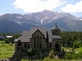
| − | [[Image:Colorado Rocky Mtn Church.jpg|thumb|upright|The Chapel on the Rock at Camp Saint Malo near [[Allenspark, Colorado|Allenspark]].]]
| + | Colorado women were granted the [[Women's suffrage|right to vote]] in 1893, making Colorado the first U.S. state to grant universal suffrage by popular vote. |
| − | [[Image:Great Stupa of Dharmakaya 1.jpg|thumb|upright|The [[stupa|Great Stupa]] of [[Dharmakaya]] near [[Red Feather Lakes, Colorado|Red Feather Lakes]].]]
| |
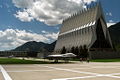
| − | [[Image:USAFA Chapel from terrazzo.JPG|thumb|upright|The Cadet Chapel at the [[United States Air Force Academy]] near [[Colorado Springs, Colorado|Colorado Springs]].]]
| |
| − | Colorado has a higher number of younger persons in median age: 33, according to the 2000 Census report. Large numbers of married couples in professional careers with young children move to the state in a belief it's a better place to raise a family. Colorado is also a major retirement destination by [[senior citizens]] in search of a warmer climate, recreation activities and the higher altitude in most of Colorado is said to provide health benefits for those with respiratory diseases.
| |
| | | | |
| − | ===Religion=== | + | ===Modern period=== |
| − | Colorado's population is predominately [[Christianity|Christian]], although it has a high percentage of religiously unaffiliated residents like most other Western states. Colorado, and specifically the [[Colorado Springs, Colorado|City of Colorado Springs]], serves as the headquarters of numerous Christian groups, many of them [[Evangelicalism#Evangelicalism_in_the_United_States|Evangelical]]. [[Focus on the Family (United States)|Focus on the Family]] is a major conservative Christian organization headquartered in Colorado Springs. [[Roman Catholic Church|Catholicism]] is popular in Colorado, and is becoming more so with the influx of Latino [[immigrants]]. | + | By the 1930 census, the population of Colorado exceeded one million residents. The state suffered through the [[Great Depression]] and the [[Dust Bowl]] of the 1930s, but a major wave of immigration following [[World War II]] boosted Colorado's fortunes. [[Tourism]] became a mainstay of the state economy, and [[technology|high technology]] became an important economic engine. Colorado's [[population]] exceeded 4.3 million by the 2000 census. |
| | | | |
| − | Major religious affiliations of the people of Colorado are:<ref>[http://religions.pewforum.org/maps U.S. Religion Map and Religious Populations - U.S. Religious Landscape Study - Pew Forum on Religion & Public Life<!-- Bot generated title —>]</ref>
| + | ==Government and Politics== |
| − | *[[Christianity|Christian]] – 65%
| + | [[Image:Denver capital.jpg|thumb|upright|left|The Colorado State Capitol in [[Denver, Colorado|Denver]]]] |
| − | **[[Protestantism|Protestant]] – 44%
| + | The governor heads the state's executive branch. The Colorado Supreme Court is the highest judicial body in the state. The state legislative body is the Colorado General Assembly, which is made up of two houses, the House of Representatives and the Senate. The House has 65 members and the Senate has 35. The 2005 Colorado General Assembly was the first to be controlled by the Democrats in forty years. |
| − | ***[[Evangelicalism#Evangelicalism_in_the_United_States|Evangelical]] – 23%
| |
| − | ***[[Mainline (Protestant)|Mainline]] – 19%
| |
| − | ***Other Protestant – 2%
| |
| − | **[[Roman Catholicism in the United States|Roman Catholic]] – 19%
| |
| − | **[[The Church of Jesus Christ of Latter-day Saints|Latter Day Saint]] – 2%
| |
| − | *[[Jewish]] – 2%
| |
| − | *[[Muslim]] – 1%
| |
| − | *Other Religions – 1%
| |
| − | *Unaffiliated – 31%
| |
| | | | |
| − | The largest denominations by number of adherents in 2000 were the [[Roman Catholic Church]] with 752,505; the [[Church of Jesus Christ of Latter-day Saints]] with 92,326; and the [[Southern Baptist Convention]] with 85,083. <ref>http://www.thearda.com/mapsReports/reports/state/08_2000.asp</ref>
| + | Colorado is considered a swing state in both state and federal elections. Coloradans elected 17 [[Democratic Party (United States)|Democrats]] and 12 [[Republican Party (United States)|Republicans]] to the governorship in the last 100 years. In presidential politics, Colorado supported Democrats [[Bill Clinton]] in 1992 and [[Barack Obama]] in 2008, and supported Republican presidential nominee [[Robert J. Dole]] in 1996 and [[George W. Bush]] in 2000 and 2004. |
| | | | |
| − | === Health ===
| + | Colorado politics has the contrast of conservative cities and liberal cities. Democrats are strongest in metropolitan Denver, the college towns of Fort Collins and Boulder, southern Colorado (including Pueblo), and a few western ski resort counties. The Republicans are strongest in the Eastern Plains, Colorado Springs, Greeley, some Denver suburbs, and the western half of the state (including Grand Junction). |
| − | Colorado also has a reputation for being a state of very active and athletic people. According to several studies, Coloradoans have the lowest rates of obesity of any state in the US.<ref>http://calorielab.com/news/wp-images/post-images/fattest-states-2007-big.gif</ref> As of 2007 the 17.6% of the population was considered medically obese, and while the lowest in the nation, the percentage had increased from 16.9% from 2004. Colorado Governor Bill Ritter spoke that “As an avid fisherman and bike rider, I know first-hand that Colorado provides a great environment for active, healthy lifestyles,” although he did highlight the need for continued education and support to slow the growth of obesity in the state.<ref>http://calorielab.com/news/2007/08/06/fattest-states-2007/</ref> | |
| − | {{clear}}
| |
| | | | |
| | ==Economy== | | ==Economy== |
| − | [[Image:2006 CO Proof.png|thumb|left|125px|The quarter for Colorado, released <br> [[June 14]] 2006.]]
| + | |
| | [[Image:Denver CO DT WTC AMH 322.JPG|thumb|upright|right|The Denver financial district along 17th Street is known as the "Wall Street of the West"]] | | [[Image:Denver CO DT WTC AMH 322.JPG|thumb|upright|right|The Denver financial district along 17th Street is known as the "Wall Street of the West"]] |
| − | [[Image:Corn production in Colorado.jpg|thumb|upright|right|[[Maize]] growing in [[Larimer County, Colorado|Larimer County]]]]
| |
| − | [[Image:DSCN2549 beevesnearwalden 600.jpg|thumb|upright|right|[[Cattle ranching]] in [[Jackson County, Colorado|Jackson County]]]]
| |
| − | [[Image:Grand Junction Trip 92007 131.JPG|thumb|upright|right|An oil well in western Colorado]]
| |
| − | {{main article|Economy of Colorado}}
| |
| − | The [[Bureau of Economic Analysis]] estimates that the total state product in 2006 was $230 billion. Per capita personal income in 2003 was $34,561, putting Colorado eighth in the nation. To see a 2004 per capita personal income comparison table on a state basis.<ref>http://www.bea.gov/bea/newsrel/spi_highlights.pdf</ref> The state's economy broadened from its mid-19th century roots in mining when irrigated agriculture developed, and by the late 19th century, raising livestock had become important. Early industry was based on the extraction and processing of minerals and agricultural products. Current agricultural products are [[cattle]], [[wheat]], [[dairy product]]s, [[maize|corn]], and [[hay]].
| |
| | | | |
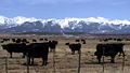
| − | The [[Federal government of the United States|federal government]] is also a major economic force in the state with many important federal facilities including [[NORAD]], [[United States Air Force Academy]] and [[Peterson Air Force Base]] in [[Colorado Springs]]; [[NOAA]] and the [[National Institute of Standards and Technology]] in [[Boulder, CO|Boulder]]; [[U.S. Geological Survey]] and other government agencies at the Denver Federal Center in [[Lakewood, CO|Lakewood]]; the [[Denver Mint]], [[Buckley Air Force Base]], and [[United States Court of Appeals for the Tenth Circuit|10th Circuit Court of Appeals]] in Denver; and a federal [[ADX Florence|Supermax Prison]] and other federal [[prisons]] near [[Cañon City, CO|Cañon City]]. In addition to these and other [[Independent Agencies of the United States Government|federal agencies]], Colorado has abundant [[National Forests|National Forest]] land and four [[List of U.S. national parks by state#Colorado|National Parks]] that contribute to federal ownership of {{convert|24615788|acre|km2|0}} of land in Colorado, or 37% of the total area of the state.<ref>{{cite web |url=http://www.ag.state.co.us/resource/documents/TotalCOLandOwnership.xls |title=Colorado Land Ownership by County (acres) |year=1997 |month=January |author=Tony Frank |format=Excel |publisher=Colorado Department of Agriculture |accessdate=2007-07-15}} [http://www.ag.state.co.us/resource/colorado_land_ownership.html Colorado Department of Agriculture: Land Ownership]</ref> | + | The state's economy broadened from its mid-nineteenth- century roots in [[mining]] when [[irrigation|irrigated]] [[agriculture]] developed, and by the late nineteenth century, raising [[livestock]] had become important. Early industry was based on the extraction and processing of [[mineral]]s and agricultural products. Current agricultural products are [[cattle]], [[wheat]], [[dairy product]]s, [[maize|corn]], and [[hay]]. |
| − | In the second half of the 20th century, the industrial and service sectors have expanded greatly. The state's economy is diversified and is notable for its concentration of scientific research and high-technology industries. Other industries include [[food processing]], transportation equipment, machinery, chemical products, minerals such as [[Gold mining in Colorado|gold]] and [[molybdenum]], and [[tourism]]. Colorado also produces the largest amount of [[beer]] of any state.<ref>[http://www.rockymountainnews.com/news/2007/nov/24/reuteman-colorado-rides-on-fat-tire-to-beer/ Colorado rides on Fat Tire to beer heights. Rocky Mountain News 11/24/2007] Accessed 29th November, 2007</ref> Denver is an important financial center.
| |
| | | | |
| − | Colorado has a flat 4.63% [[income tax]], regardless of income level. Unlike most states, which calculate taxes based on federal ''adjusted gross income'', Colorado taxes are based on ''taxable income'' - income after federal exemptions and federal itemized (or standard) deductions.<ref>Colorado individual income tax return (2005) [http://www.revenue.state.co.us/PDF/05104f.pdf http://www.revenue.state.co.us/PDF/05104f.pdf], retrieved September 26, 2006</ref><ref>U.S. Individual Income Tax Return (2005) [http://www.irs.gov/pub/irs-pdf/f1040.pdf#search=%22form%201040%20site%3Airs.gov%22 online copy], retrieved [[2006-09-26]]</ref> Colorado's state [[sales tax]] is 2.9% on retail sales. When state revenues exceed state constitutional limits, full-year Colorado residents can claim a sales tax refund on their individual state income tax return. Many counties and cities charge their own rates in addition to the base state rate. There are also certain county and special district taxes that may apply.
| + | The Bureau of Economic Analysis estimates that the total state product in 2006 was $230 billion. Per capita personal income in 2003 was $34,561, putting Colorado eighth in the nation. |
| | + | The federal government is a major economic force in the state with many important federal facilities including [[NORAD]], [[United States Air Force Academy]], Fort Carson (with a population of over ten thousand), and Peterson Air Force Base in [[Colorado Springs]]; the [[National Oceanic and Atmospheric Administration]] and the [[National Institute of Standards and Technology]] in Boulder; [[U.S. Geological Survey]] and other government agencies at the Denver Federal Center in Lakewood; the Denver Mint, Buckley Air Force Base, and 10th Circuit Court of Appeals in Denver; and a federal Supermax Prison and other federal [[prison]]s near Cañon City. |
| | | | |
| − | [[Real estate]] and personal business property are taxable in Colorado. The state's senior property tax exemption was temporarily suspended by the Colorado Legislature in 2003. The tax break is scheduled to return for assessment year 2006, payable in 2007. | + | In addition to these and other federal agencies, Colorado has abundant [[National Forests|National Forest]] land and four [[National Park]]s that contribute to federal ownership of {{convert|24615788|acre|km2|0}} of land in Colorado, or 37 percent of the total area of the state.<ref>Tony Frank. January 1997. [http://www.ag.state.co.us/resource/documents/TotalCOLandOwnership.xls Colorado Land Ownership by County (acres)] ''Colorado Department of Agriculture''. Retrieved July 15, 2007. </ref> |
| | | | |
| − | ===Energy===
| + | In the second half of the twentieth century, the industrial and service sectors expanded greatly. The state's economy is diversified and is notable for its concentration of scientific research and high-technology industries. Other industries include [[food processing]], [[transportation]] equipment, [[machinery]], [[chemical]] products, [[mineral]]s such as [[gold]] and [[molybdenum]], and [[tourism]]. Colorado also produces the largest amount of [[beer]] of any state.<ref>Rob Reuteman. November 24, 2007. [http://www.rockymountainnews.com/news/2007/nov/24/reuteman-colorado-rides-on-fat-tire-to-beer/ Colorado rides on Fat Tire to beer heights] ''Rocky Mountain News''. Retrieved December 1, 2008.</ref> The city of Denver is an important financial center. |
| − | Colorado has significant energy resources. According to the [[Energy Information Administration]], Colorado hosts seven of the Nation’s 100 largest natural gas fields and two of its 100 largest oil fields. Conventional and unconventional natural gas output from several Colorado basins typically accounts for more than 5 percent of annual U.S. natural gas production. Substantial deposits of bituminous, subbituminous, and lignite coal are also found in the State. Colorado's high Rocky Mountain ridges offer wind power potential, and geologic activity in the mountain areas provides potential for geothermal power development. Major rivers flowing from the Rocky Mountains offer hydroelectric power resources. Corn grown in the flat eastern part of the State offers potential resources for ethanol production. Notably, Colorado’s oil shale deposits hold an estimated {{convert|1|Toilbbl|km3}} of oil – nearly as much oil as the entire world’s proven oil reserves. Oil production from those deposits, however, remains speculative.<ref>{{cite web |url=http://tonto.eia.doe.gov/state/state_energy_profiles.cfm?sid=CO |title= EIA State Energy Profiles: Colorado |date=2008-06-12 |accessdate=2008-06-24}}</ref>
| |
| | | | |
| − | ===Special tax districts===
| + | {{wide image|2006-07-14-Denver Skyline Midnight.jpg|750px|The skyline of downtown Denver with Speer Boulevard in the foreground}} |
| − | Some of the special tax districts are:
| |
| − | *The [[Regional Transportation District]] (RTD), which affects the counties of Denver, Boulder, Jefferson, and portions of Adams, Arapahoe, Broomfield, and Douglas Counties
| |
| − | *The [[Scientific and Cultural Facilities District]] (SCFD), a special regional tax district with physical boundaries contiguous with county boundaries of Adams, Arapahoe, Boulder, Broomfield, Denver, Douglas, and Jefferson Counties
| |
| − | **It is a 0.1% retail sales and use tax (one penny on every $10).
| |
| − | **According to the Colorado statute, the SCFD distributes the money to local organizations on an annual basis. These organizations must provide for the enlightenment and entertainment of the public through the production, presentation, exhibition, advancement or preservation of art, music, theater, dance, zoology, botany, natural history or cultural history.
| |
| − | **As directed by statute, SCFD recipient organizations are currently divided into three "tiers" among which receipts are allocated by percentage.
| |
| − | ***Tier I includes regional organizations: the Denver Art Museum, the Denver Botanic Gardens, the Denver Museum of Nature and Science, the Denver Zoo, and the Denver Center for the Performing Arts. It receives 65.5%.
| |
| − | ***Tier II currently includes 26 regional organizations. Tier II receives 21%.
| |
| − | ***Tier III has over 280 local organizations such as small theaters, orchestras, art centers, and natural history, cultural history, and community groups. Tier III organizations apply for funding to the county cultural councils via a grant process. This tier receives 13.5%.
| |
| − | **An eleven-member board of directors oversees the distributions in accordance with the Colorado Revised Statutes. Seven board members are appointed by county commissioners (in Denver, the Denver City Council) and four members are appointed by the Governor of Colorado.
| |
| − | *The Football Stadium District (FD or FTBL), approved by the voters to pay for and help build the [[Denver Broncos]]' stadium [[INVESCO Field at Mile High]]
| |
| − | *Local Improvement Districts (LID) within designated areas of southeast Jefferson and Boulder counties
| |
| − | *Regional Transportation Districts (RTA) taxes at varying rates in Basalt, Carbondale, Glenwood Springs, Gunnison County
| |
| − | *Occupational Privilege Taxes (OPT or Head Tax) Denver and Aurora both levy an OPT on Employers and Employees
| |
| − | **If any employee performs work in the city limits and is paid over US$500.00 for that work in a single month, the Employee and Employer are both liable for the OPT regardless of where the main business office is located or headquartered.
| |
| − | **In Denver, the Employer is liable for US$4.00 per employee per month and the Employee is liable for US$5.75 per month.
| |
| − | **In Aurora, both Employer and Employees are liable for US$2.00 per month.
| |
| − | **It is the Employer's responsibility to with hold, remit, and file the OPT returns. If an Employer does not comply, they can be held liable for both portions of the OPT as well as penalties and interest.
| |
| − | {{clear}}
| |
| | | | |
| − | ==Transportation== | + | ==Demographics== |
| − | [[Image:Colorado.JPG|thumb|upright|Colorado state welcome sign]] | + | [[Image:Colorado population map.png|thumb|275px|Colorado Population Density Map]] |
| − | [[Image:Denver International Airport security.jpg|thumb|upright|Denver International Airport]] | + | The state's most populous city, and its capital, is [[Denver, Colorado|Denver]]. The Denver-Aurora-Boulder Combined Statistical Area, home to 2,927,911 people, contains more than two-thirds of the state's population. |
| − | [[Image:UnionStationDenver01 gobeirne.jpg|thumb|upright|[[Union Station (Denver)|Union Station]] in Denver]]
| + | |
| − | <center>
| + | The United States Census Bureau estimates that the state population was 4,861,515 in 2007, a 13.03 percent increase since 2000. Large numbers of new residents in the state originate from [[California]], drawn by a lower cost of living and a healthier economy. Others moved in from [[East Coast of the United States|East Coast]] states. |
| − | {|
| |
| − | |+ '''Interstate and Federal Highway Routes in the State of Colorado'''
| |
| − | |-
| |
| − | | valign="top" |
| |
| − | *[[Image:I-25 (CO).svg|20px]] [[Interstate 25]]
| |
| − | *[[Image:I-70 (CO).svg|20px]] [[Interstate 70]]
| |
| − | *[[Image:I-76 (CO).svg|20px]] [[Interstate 76 (west)|Interstate 76]]
| |
| − | *[[Image:I-225 (CO).svg|25px]] [[Interstate 225 (Colorado)|Interstate 225]]
| |
| − | *[[Image:I-270 (CO).svg|25px]] [[Interstate 270 (Colorado)|Interstate 270]]
| |
| − | | valign="top" |
| |
| − | *[[Image:US 6.svg|20px]] [[U.S. Route 6]]
| |
| − | *[[Image:US 24.svg|20px]] [[U.S. Route 24]]
| |
| − | *[[Image:US 34.svg|20px]] [[U.S. Route 34]]
| |
| − | *[[Image:US 36.svg|20px]] [[U.S. Route 36]]
| |
| − | *[[Image:US 40.svg|20px]] [[U.S. Route 40]]
| |
| − | *[[Image:US 50.svg|20px]] [[U.S. Route 50]]
| |
| − | | valign="top" |
| |
| − | *[[Image:US 84.svg|20px]] [[U.S. Route 84]]
| |
| − | *[[Image:US 85.svg|20px]] [[U.S. Route 85]]
| |
| − | *[[Image:US 87.svg|20px]] [[U.S. Route 87]]
| |
| − | *[[Image:US 138.svg|25px]] [[U.S. Route 138]]
| |
| − | *[[Image:US 160.svg|25px]] [[U.S. Route 160]]
| |
| − | *[[Image:US 285.svg|25px]] [[U.S. Route 285]]
| |
| − | | valign="top" |
| |
| − | *[[Image:US 287.svg|25px]] [[U.S. Route 287]]
| |
| − | *[[Image:US 350.svg|25px]] [[U.S. Route 350]]
| |
| − | *[[Image:US 400.svg|25px]] [[U.S. Route 400]]
| |
| − | *[[Image:US 491.svg|25px]] [[U.S. Route 491]]
| |
| − | *[[Image:US 550.svg|25px]] [[U.S. Route 550]]
| |
| − | |}
| |
| | | | |
| − | {|
| + | According to the 2000 census, the largest ancestry groups in Colorado are [[Germany|German]] (22 percent) (including of Swiss and Austrian nationalities), [[Ireland|Irish]] (12.2 percent), and [[England|English]] (12 percent). Persons reporting German ancestry are the largest group in the state and are especially strong in the Front Range, the Rockies (west-central counties) and eastern parts/High Plains. Denver and nearby areas on the Front Range have sizable Scandinavian, [[Italy|Italian]], Slavic, and [[Jewish American]] communities, partly a legacy of [[Gold Rush]]es in the late nineteenth century (1861-1889). |
| − | |+ '''Commercial Airports in the State of Colorado'''
| |
| − | |-
| |
| − | | valign="top" |
| |
| − | *[[San Luis Valley Regional Airport|ALS]] - [[San Luis Valley Regional Airport]]
| |
| − | *[[Aspen-Pitkin County Airport|ASE]] - [[Aspen-Pitkin County Airport]]
| |
| − | *[[Cortez Municipal Airport|CEZ]] - [[Cortez Municipal Airport]]
| |
| − | *[[Colorado Springs Airport|COS]] - [[Colorado Springs Airport|City of Colorado Springs Municipal Airport]]
| |
| − | *'''[[Denver International Airport|DEN]] - [[Denver International Airport]]'''<ref name=DIA>Denver International Airport was the ninth busiest airport on Earth in 2006.</ref>
| |
| − | *[[Durango-La Plata County Airport|DRO]] - [[Durango-La Plata County Airport]]
| |
| − | *[[Eagle County Regional Airport|EGE]] - [[Eagle County Regional Airport]]
| |
| − | | valign="top" |
| |
| − | *[[Fort Collins-Loveland Municipal Airport|FNL]] - [[Fort Collins-Loveland Municipal Airport]]
| |
| − | *[[Grand Junction Regional Airport|GJT]] - [[Grand Junction Regional Airport]]
| |
| − | *[[Gunnison-Crested Butte Regional Airport|GUC]] - [[Gunnison-Crested Butte Regional Airport]]
| |
| − | *[[Yampa Valley Airport|HDN]] - [[Yampa Valley Airport]]
| |
| − | *[[Montrose Regional Airport|MTJ]] - [[Montrose Regional Airport]]
| |
| − | *[[Pueblo Memorial Airport|PUB]] - [[Pueblo Memorial Airport]]
| |
| − | *[[Telluride Regional Airport|TEX]] - [[Telluride Regional Airport]]
| |
| − | |}
| |
| − | </center>
| |
| | | | |
| − | {|
| + | Colorado has one of the highest proportions of [[Hispanic]] citizens of any U.S. state, with over 19 percent reported in the 2006 census<ref>[http://quickfacts.census.gov/qfd/states/08000.html Colorado Quick Facts].''quickfacts''. Retrieved December 23, 2008.</ref>; only five states have a higher percentage. [[Denver]] and some other areas have significant [[Mexico|Mexican]] populations, while southern Colorado has a large number of descendants of early New Mexican settlers of colonial [[Spain|Spanish]] origin. The 2000 U.S. census reported that 10.52 percent of residents aged 5 and over in Colorado speak [[Spanish language|Spanish]] at home. |
| − | |+ '''Amtrak Passenger Railroad Routes through the State of Colorado'''
| |
| − | |-
| |
| − | | valign="top" |
| |
| − | *'''''[[California Zephyr]]:''''' [[Chicago, Illinois|Chicago]], [[Galesburg, Illinois|Galesburg]], [[Omaha, Nebraska|Omaha]], '''[[Fort Morgan, Colorado|Fort Morgan]], [[Denver, Colorado|Denver]], [[Winter Park, Colorado|Winter Park]], [[Granby, Colorado|Granby]], [[Glenwood Springs, Colorado|Glenwood Springs]], [[Grand Junction, Colorado|Grand Junction]]''', [[Salt Lake City, Utah|Salt Lake City]], [[Reno, Nevada|Reno]], [[Sacramento, California|Sacramento]], and [[Emeryville, California|Emeryville]]
| |
| − | *'''''[[Southwest Chief]]:''''' [[Chicago, Illinois|Chicago]], [[Galesburg, Illinois|Galesburg]], [[Kansas City, Missouri|Kansas City]], [[Topeka, Kansas|Topeka]], '''[[Lamar, Colorado|Lamar]], [[La Junta, Colorado|La Junta]], [[Trinidad, Colorado|Trinidad]]''', [[Albuquerque, New Mexico|Albuquerque]], [[Gallup, New Mexico|Gallup]], [[Flagstaff, Arizona|Flagstaff]], [[Needles, California|Needles]], [[San Bernardino, California|San Bernardino]], and [[Los Angeles, California|Los Angeles]]
| |
| − | |}
| |
| | | | |
| − | {|
| + | The state also has a history of [[African American]] communities which are located in northeast Denver in the Montbello, Green Valley Ranch, Park Hill, and Colfax Park areas. The state has sizable numbers of Asian-Americans of Chinese, Filipino, Korean, Southeast Asian, and Japanese descent. |
| − | |+ '''Communities in the State of Colorado with Regional Bus Service'''
| |
| − | |-
| |
| − | | valign="top" |
| |
| − | [[Alamosa, Colorado|Alamosa]], [[Aurora, Colorado|Aurora]], [[Boulder, Colorado|Boulder]], [[Brush, Colorado|Brush]], '''[[Colorado Springs, Colorado|Colorado Springs]]''', [[Delta, Colorado|Delta]], '''[[Denver, Colorado|Denver]]''', [[Durango, Colorado|Durango]], [[Englewood, Colorado|Englewood]], [[Frisco, Colorado|Frisco]], '''[[Fort Collins, Colorado|Fort Collins]]''', [[Fort Morgan, Colorado|Fort Morgan]], [[Glenwood Springs, Colorado|Glenwood Springs]], '''[[Grand Junction, Colorado|Grand Junction]]''', '''[[Greeley, Colorado|Greeley]]''', [[Lamar, Colorado|Lamar]], [[Limon, Colorado|Limon]], [[Longmont, Colorado|Longmont]], [[Montrose, Colorado|Montrose]], '''[[Pueblo, Colorado|Pueblo]]''', [[Rocky Ford, Colorado|Rocky Ford]], [[Springfield, Colorado|Springfield]], [[Sterling, Colorado|Sterling]], [[Trinidad, Colorado|Trinidad]], [[Vail, Colorado|Vail]], and [[Walsenburg, Colorado|Walsenburg]] | |
| − | |}
| |
| − | {{see also|Colorado Department of Transportation|List of Colorado state highways|List of airports in Colorado|Amtrak}}
| |
| − | {{clear}}
| |
| | | | |
| − | ==Government and Politics==
| + | With its median age of 33, Colorado has a higher number of younger persons, according to the 2000 census. Large numbers of married couples in professional careers with young children are moving to the state in a belief it's a better place to raise families. Colorado is also a major retirement destination by senior citizens in search of a warmer climate, recreation activities, and higher altitude, which is said to be healthier for those with respiratory diseases. |
| − | ===State government===
| |
| − | {{main|Law and Government of Colorado}}
| |
| − | [[Image:Denver capital.jpg|thumb|upright|left|The Colorado State Capitol in Denver]]
| |
| − | {| align="right" border="2" cellpadding="4" cellspacing="0" style="margin: 1em 1em 1em 0; border: 1px #aaa solid; border-collapse: collapse; font-size: 75%;"
| |
| − | |+ '''Governor elections results'''
| |
| − | |- bgcolor=lightgrey
| |
| − | ! Year
| |
| − | ! [[Republican Party (United States)|Republican]]
| |
| − | ! [[Democratic Party (United States)|Democratic]]
| |
| − | |-
| |
| − | |align="center" bgcolor="#f0f0ff"|[[United States gubernatorial elections, 2006|2006]]
| |
| − | |align="center" bgcolor="#fff3f3"|40.16% ''625,886
| |
| − | |align="center" bgcolor="#f0f0ff"|'''56.98%''' ''888,096
| |
| − | |-
| |
| − | |align="center" bgcolor="#fff3f3"|[[United States gubernatorial elections, 2002|2002]]
| |
| − | |align="center" bgcolor="#fff3f3"|'''62.62%''' ''884,584
| |
| − | |align="center" bgcolor="#f0f0ff"|33.65% ''475,373
| |
| − | |-
| |
| − | |align="center" bgcolor="#fff3f3"|[[United States gubernatorial elections, 1998|1998]]
| |
| − | |align="center" bgcolor="#fff3f3"|'''49.06%''' ''648,202
| |
| − | |align="center" bgcolor="#f0f0ff"|48.43% ''639,905
| |
| − | |-
| |
| − | |align="center" bgcolor="#f0f0ff"|[[United States gubernatorial elections, 1994|1994]]
| |
| − | |align="center" bgcolor="#fff3f3"|38.70% ''432,042
| |
| − | |align="center" bgcolor="#f0f0ff"|'''55.47%''' ''619,205
| |
| − | |-
| |
| − | |align="center" bgcolor="#f0f0ff"|[[United States gubernatorial elections, 1990|1990]]
| |
| − | |align="center" bgcolor="#fff3f3"|35.43% ''358,403
| |
| − | |align="center" bgcolor="#f0f0ff"|'''61.89%''' ''626,032
| |
| − | |}
| |
| | | | |
| − | Like all [[U.S. state]]s, Colorado's [[constitution]] provides for three branches of government: the legislative, executive, and judicial branches. The [[List of Governors of Colorado|governor]] heads the state's executive branch. The [[Colorado Supreme Court]] is the highest judicial body in the state. The state legislative body is the [[Colorado General Assembly]], which is made up of two houses, the [[Colorado House of Representatives|House of Representatives]] and the [[Colorado Senate|Senate]]. The House has 65 members and the Senate has 35. Currently, [[United States Democratic Party|Democrats]] are in control of both chambers of the General Assembly. The 2005 Colorado General Assembly was the first to be controlled by the Democrats in forty years. The incumbent Governor of the State of Colorado is [[Bill Ritter (politician)|August William "Bill" Ritter, Jr.]] (D).
| + | The Denver metropolitan area is considered more liberal and diverse than much of the state when it comes to political issues and environmental concerns, as the Denver area rapidly grows in size, sprawl and population in the last 40 years. |
| | | | |
| − | Many Coloradans are transplanted citizens (over half of them were Californians in the 1990s), and this is illustrated by the fact that the state has not had a native-born governor since 1975 (when [[John David Vanderhoof]] left office) and — until [[Colorado gubernatorial election, 2006|Bill Ritter's election in November 2006]] — had not elected one since 1958, in the person of [[Stephen L.R. McNichols]]. Vanderhoof ascended from the Lieutenant Governorship when [[John Arthur Love]] was given a position in [[Richard Nixon]]'s administration in 1973.) [[Bill Ritter (politician)|Bill Ritter]] (D), a humanitarian missionary worker in Africa and former Denver District Attorney, defeated former congressman and banker [[Bob Beauprez]] (R) in the [[Colorado gubernatorial election, 2006|2006 gubernatorial election]].
| + | ===Religion=== |
| − | {{clear}}
| + | Colorado's population is predominately [[Christianity|Christian]], although it has a high percentage of religiously unaffiliated residents (like most other Western states). Colorado, and specifically [[Colorado Springs, Colorado|Colorado Springs]], serves as the headquarters of numerous Christian groups, many of them [[Evangelicalism|Evangelical]]. [[Focus on the Family]] is a major conservative Christian organization headquartered in Colorado Springs. [[Roman Catholic Church|Catholicism]] is popular in Colorado, and is becoming more so with the influx of Latino [[immigrants]]. |
| − | | |
| − | ===Federal politics=== | |
| − | {{main|Politics of Colorado}}
| |
| − | {| align="right" border="2" cellpadding="4" cellspacing="0" style="margin: 1em 1em 1em 0; border: 1px #aaa solid; border-collapse: collapse; font-size: 75%;"
| |
| − | |+ '''Presidential elections results'''
| |
| − | |- bgcolor=lightgrey
| |
| − | ! Year
| |
| − | ! [[Republican Party (United States)|Republican]]
| |
| − | ! [[Democratic Party (United States)|Democratic]]
| |
| − | |-
| |
| − | |align="center" bgcolor="#fff3f3"|[[U.S. presidential election, 2004|2004]]
| |
| − | |align="center" bgcolor="#fff3f3"|'''51.69%''' ''1,101,255
| |
| − | |align="center" bgcolor="#f0f0ff"|47.02% ''1,001,732
| |
| − | |-
| |
| − | |align="center" bgcolor="#fff3f3"|[[U.S. presidential election, 2000|2000]]
| |
| − | |align="center" bgcolor="#fff3f3"|'''50.75%''' ''883,745
| |
| − | |align="center" bgcolor="#f0f0ff"|42.39% ''738,227
| |
| − | |-
| |
| − | |align="center" bgcolor="#fff3f3"|[[U.S. presidential election, 1996|1996]]
| |
| − | |align="center" bgcolor="#fff3f3"|'''45.80%''' ''691,848
| |
| − | |align="center" bgcolor="#f0f0ff"|44.43% ''671,152
| |
| − | |-
| |
| − | |align="center" bgcolor="#f0f0ff"|[[U.S. presidential election, 1992|1992]]
| |
| − | |align="center" bgcolor="#fff3f3"|35.87% ''562,850
| |
| − | |align="center" bgcolor="#f0f0ff"|'''40.13%''' '' ''629,681
| |
| − | |-
| |
| − | |align="center" bgcolor="#fff3f3"|[[U.S. presidential election, 1988|1988]]
| |
| − | |align="center" bgcolor="#fff3f3"|'''53.06%''' ''728,177
| |
| − | |align="center" bgcolor="#f0f0ff"|45.28% ''621,453
| |
| − | |}
| |
| − | | |
| − | Colorado is considered a [[swing state]] in both state and federal elections. Coloradans elected 17 [[Democratic Party (United States)|Democrats]] and 12 [[Republican Party (United States)|Republicans]] to the governorship in the last 100 years. In presidential politics, Colorado supported Democrat [[Bill Clinton]] in 1992, and supported Republican presidential nominee [[Bob Dole|Robert J. Dole]] in 1996 and [[George W. Bush]] in [[United States presidential election, 2000|2000]], and [[United States presidential election, 2004|2004]].
| |
| | | | |
| − | Colorado politics has the contrast of conservative cities such as Colorado Springs and liberal cities such as Boulder. Democrats are strongest in [[Denver Metropolitan Area|metropolitan Denver]], the college towns of [[Fort Collins, Colorado|Fort Collins]] and [[Boulder, Colorado|Boulder]], southern Colorado (including Pueblo), and a few western ski resort counties. The Republicans are strongest in the Eastern Plains, [[Colorado Springs]], Greeley, some Denver suburbs, and the western half of State (including Grand Junction). The fastest growing parts of the state particularly Douglas, Elbert, and Weld Counties, in the [[Denver-Aurora Metropolitan Area]], are somewhat Republican.
| + | Major religious affiliations of the people of Colorado are:<ref>''The Pew Forum on Religion & Public Life''. [http://religions.pewforum.org/maps U.S. Religion Map and Religious Populations] Retrieved December 1, 2008.</ref> |
| | + | *[[Christianity|Christian]] – 65 percent |
| | + | **[[Protestantism|Protestant]] – 44 percent |
| | + | ***[[Evangelicalism|Evangelical]] – 23 percent |
| | + | ***Mainline – 19 percent |
| | + | ***Other Protestant – 2 percent |
| | + | **[[Roman Catholic]] – 19 percent |
| | + | **[[Church of Jesus Christ of Latter-day Saints|Latter Day Saint]] – 2 percent |
| | + | *[[Jewish]] – 2 percent |
| | + | *[[Muslim]] – 1 percent |
| | + | *Other Religions – 1 percent |
| | + | *Unaffiliated – 31 percent |
| | | | |
| − | The two current U.S. [[United States Senate|Senators]] from Colorado are [[Wayne Allard]] (R), and [[Ken Salazar]] (D). The state has seven [[Colorado Congressional Districts|U.S. Congressional districts]], based on the [[United States Census, 2000|2000 Census]]. | + | The largest denominations by number of adherents in 2000 were the [[Roman Catholic Church]] with 752,505; the [[Church of Jesus Christ of Latter-day Saints]] with 92,326; and the [[Baptist|Southern Baptist Convention]] with 85,083. <ref>''The Association of Religion Data Archives.'' [http://www.thearda.com/mapsReports/reports/state/08_2000.asp Colorado Denominational Groups, 2000] Retrieved December 1, 2008.</ref> |
| − | | |
| − | {{see also|United States presidential election, 2004, in Colorado|Colorado's congressional elections, 2006|Colorado gubernatorial election, 2006}}
| |
| − | {{clear}}
| |
| − | | |
| − | ==Cities and Towns==
| |
| − | {{main|Colorado municipalities}}
| |
| − | {{see also|List of cities and towns in Colorado|Table of Colorado municipalities by county}}
| |
| − | Colorado has 271 [[Colorado municipalities|incorporated municipalities]] and 83 active [[United States Census Bureau|United States]] [[Census Designated Place]]s.<ref name=COmuniStatus>{{cite web | date = [[2006-09-18]] | url = http://www.dola.state.co.us/LGS/localgovtinfo/municipalities.htm | title = Active Colorado Municipalities as of September 18, 2006 | format = [[HTML]] | publisher = State of Colorado, Department of Local Affairs | accessdate = 2007-01-08 }}</ref><ref name=Census2000Places>{{cite web | date = 2000 | url = http://www.census.gov/tiger/tms/gazetteer/places2k.txt | title = Census 2000 Places | format = [[text file]] | work = Census 2000 U.S. Gazetteer Files | publisher = U.S. Census Bureau, Population Division | accessdate = 2007-01-08 }}</ref>
| |
| − | {{-}}
| |
| − | {{wide image|2006-07-14-Denver Skyline Midnight.jpg|847px|The skyline of downtown [[Denver, CO|Denver]] with Speer Boulevard in the foreground}}
| |
| − | | |
| − | ==Counties==
| |
| − | [[Image:Map of Colorado counties, labelled.svg|thumb|Map of the 64 counties of the State of Colorado.]]
| |
| − | {{main|Colorado counties}}
| |
| − | Colorado is divided into 64 [[county (United States)|counties]], including two counties with [[Consolidated city-county|consolidated city and county governments]].<ref name= CountiesCO>{{cite web | date = [[2007-01-08]] | url = http://www.dola.state.co.us/dlg/local_governments/counties.html | title = Colorado Counties | format = [[HTML]] | publisher = State of Colorado, Department of Local Affairs | accessdate = 2007-01-30 }}</ref>
| |
| − | | |
| − | The ten most populous Colorado counties as of [[2007-07-01]], were:<ref name=PopEstCounty>{{cite web | url = http://www.census.gov/popest/counties/files/CO-EST2007-ALLDATA.csv | title = Annual County Population Estimates and Estimated Components of Change: April 1, 2000 to July 1, 2007 | format = [[comma-separated values|CSV]] | work = 2007 Population Estimates | publisher = [[United States Census Bureau]], Population Division | date = [[2008-03-20]] | accessdate = 2008-09-25}}</ref> | |
| − | #[[Denver, Colorado|City and County of Denver]]
| |
| − | #[[El Paso County, Colorado|El Paso County]]
| |
| − | #[[Arapahoe County, Colorado|Arapahoe County]]
| |
| − | #[[Jefferson County, Colorado|Jefferson County]]
| |
| − | #[[Adams County, Colorado|Adams County]]
| |
| − | #[[Boulder County, Colorado|Boulder County]]
| |
| − | #[[Larimer County, Colorado|Larimer County]]
| |
| − | #[[Douglas County, Colorado|Douglas County]]
| |
| − | #[[Weld County, Colorado|Weld County]]
| |
| − | #[[Pueblo County, Colorado|Pueblo County]]
| |
| | | | |
| | ==Education== | | ==Education== |
| − | [[Image:Norlin Library - Colorado.jpg|thumb|upright|right|The [[University of Colorado at Boulder]].]]
| + | The Department of Education oversees 178 school districts serving over 800,000 students. Colorado offers a variety of options for elementary and secondary [[education]]: [[public school]]s, [[magnet school]]s, [[charter school]]s, [[homeschooling]], and online classes. |
| − | [[Image:University of Denver campus pics 003.jpg|upright|right|thumb|The [[University of Denver]].]]
| |
| − | [[Image:Cadet chapel.jpg|thumb|upright|right|The [[United States Air Force Academy]].]]
| |
| − | Colleges and universities in Colorado:
| |
| − | {{columns |width=320px
| |
| − | |col1 =
| |
| − | *[[Adams State College]]
| |
| − | *[[Aims Community College]]
| |
| − | *[[Arapahoe Community College]]
| |
| − | *[[Art Institute of Colorado]]
| |
| − | *[[Colorado Christian University]]
| |
| − | *[[Colorado College]]
| |
| − | *[[Colorado Community College Online]]
| |
| − | *[[Colorado Mountain College]]
| |
| − | *[[Colorado Northwestern Community College]]
| |
| − | *[[Colorado School of Mines]]
| |
| − | *[[Colorado State University|Colorado State University System]]
| |
| − | **[[Colorado State University]]
| |
| − | **[[Colorado State University-Pueblo]]
| |
| − | *[[Colorado Technical University]]
| |
| − | *[[Community College of Aurora]]
| |
| − | *[[Community College of Denver]]
| |
| − | *[[Denver Seminary]]
| |
| − | *[[DeVry University]]
| |
| − | *[[Fort Lewis College]]
| |
| − | *[[Front Range Community College]]
| |
| − | *[[Heritage College & Heritage Institute]]
| |
| − | *[[Iliff School of Theology]]
| |
| − | *[[Johnson & Wales University]]
| |
| − | *[[Jones International University]]
| |
| − | *[[Lamar Community College]]
| |
| − | |col2 =
| |
| − | *[[Mesa State College]]
| |
| − | *[[Metropolitan State College of Denver]]
| |
| − | *[[Morgan Community College]]
| |
| − | *[[Naropa University]]
| |
| − | *[[National Technological University]]
| |
| − | *[[Nazarene Bible College]]
| |
| − | *[[Northeastern Junior College]]
| |
| − | *[[Otero Junior College]]
| |
| − | *[[Pikes Peak Community College]]
| |
| − | *[[Pueblo Community College]]
| |
| − | *[[Red Rocks Community College]]
| |
| − | *[[Regis University]]
| |
| − | *[[Rocky Mountain College of Art and Design]]
| |
| − | *[[Rocky Vista University College of Osteopathic Medicine]]
| |
| − | *[[Trinidad State Junior College]]
| |
| − | *[[United States Air Force Academy]]
| |
| − | *[[University of Colorado System]]
| |
| − | **[[University of Colorado at Boulder]]
| |
| − | **[[University of Colorado at Colorado Springs]]
| |
| − | **[[University of Colorado Denver]]
| |
| − | *[[University of Denver]]
| |
| − | *[[University of Northern Colorado]]
| |
| − | *[[Western State College]]
| |
| − | }}
| |
| | | | |
| − | {{see also|List of colleges and universities in Colorado|List of school districts in Colorado}}
| + | There are 79 institutions of higher learning in the state, of which the oldest is the University of Denver, founded in 1864. Specialty schools include the U.S. Air Force Academy and the Colorado School of Mines. |
| − | {{clear}}
| + | <center> |
| | + | <gallery widths="190px"> |
| | + | Image:Norlin Library - Colorado.jpg|The University of Colorado at Boulder |
| | + | Image:University of Denver campus pics 003.jpg|The University of Denver |
| | + | Image:Cadet chapel.jpg|The United States Air Force Academy |
| | + | </gallery> |
| | + | </center> |
| | | | |
| − | ==Metropolitan Areas== | + | ==Professional sports teams== |
| − | [[Image:Colorado census statistical areas.svg|thumb|Map of the 14 [[Core Based Statistical Area]]s in the State of Colorado.]]
| + | Colorado is the least populous state with a franchise in each of the [[major professional sports league]]s. The state is able to support the teams because it contains a large [[metropolitan area]] with a higher population than any other city within {{convert|550|mi|km|0|sp=us}}. Therefore, many of the residents in the surrounding states support the [[Sports in Denver, Colorado|teams in Denver]], as shown by the reach of the Broncos' radio network, which includes affiliates in [[Kansas]], [[Montana]], [[Nebraska]], [[Nevada]], [[New Mexico]], [[North Dakota]], [[South Dakota]], and [[Wyoming]].<ref>''Denver Broncos''. [http://www.denverbroncos.com/page.php?id=1637 2007 Affiliate Stations] Retrieved December 1, 2008.</ref> |
| − | {{main|Colorado metropolitan areas}} | + | <center> |
| − | {{see also|Colorado census statistical areas}}
| + | <gallery widths="190px"> |
| − | The [[United States Census Bureau]] has defined seven [[Table of United States Metropolitan Statistical Areas|Metropolitan Statistical Areas]] (MSAs), seven [[Table of United States Micropolitan Statistical Areas|Micropolitan Statistical Areas]] (μSAs), and one [[Table of United States Combined Statistical Areas|Combined Statistical Area]] (CSA) in the State of Colorado.<ref name=PopEstCompCBSA>{{cite web | url = http://www.census.gov/population/www/estimates/metropop/2005/cbsa-01-fmt.csv | title = CBSA-EST2005-alldata: Population Estimates and Estimated Components of Change for Metropolitan and Micropolitan Statistical Areas and Their Geographic Components: April 1, 2000 to July 1, 2005 | format = [[comma-separated values|CSV]] | work = 2005 Population Estimates | publisher = [[United States Census Bureau]], Population Division | date = [[2006-08-18]] | accessdate = 2007-03-14}}</ref><ref name=PopEstCompCSA>{{cite web | url = http://www.census.gov/population/www/estimates/metropop/2005/csa_all_2005.csv | title = CSA-EST2005-alldata: Population Estimates and Estimated Components of Change for Combined Statistical Areas and Their Geographic Components: April 1, 2000 to July 1, 2005 | format = [[comma-separated values|CSV]] | work = 2005 Population Estimates | publisher = [[United States Census Bureau]], Population Division | date = [[2006-08-18]] | accessdate = 2007-03-14}}</ref>
| + | Image:Coors field 1.JPG|The [[Colorado Rockies]] [[National League]] baseball club at [[Coors Field]] in Denver. |
| | + | Image:Denver invesco stadium 1.jpg|[[INVESCO Field at Mile High]], home of the [[Denver Broncos]] [[National Football League]] club and the [[Denver Outlaws]] [[Major League Lacrosse]] club. |
| | + | Image:Pepsi Center.jpg|[[Pepsi Center]] in Denver, home of the [[Denver Nuggets]] [[National Basketball Association]] club, the [[Colorado Avalanche]] [[National Hockey League]] club, the [[Colorado Mammoth]] [[National Lacrosse League]] club, and the [[Colorado Crush]] [[Arena Football League]] club. |
| | + | Image:Dick's Park.jpg|[[Dick's Sporting Goods Park]] in [[Commerce City, Colorado|Commerce City]], home of the [[Colorado Rapids]] [[Major League Soccer]] football club. |
| | + | </gallery> |
| | + | </center> |
| | | | |
| − | ==Military Installations== | + | ==Looking to the future== |
| − | *[[Buckley Air Force Base]]
| + | Colorado's rapid population growth (2 percent annually) is placing increased demands on its [[highway]]s, housing market, utilities, [[school]]s, and other services. [[Water]] is also an issue, as it is throughout the [[Southwestern United States|Southwest]], and water [[conservation]] is mandated. Maintaining a balance between urban sprawl and the need to protect [[wilderness]] areas and wildlife habitats will continue to be a challenge. |
| − | *[[Fort Carson]]
| |
| − | **[[Piñon Canyon Maneuver Site]]
| |
| − | *[[Peterson Air Force Base]]
| |
| − | **[[Cheyenne Mountain Directorate]]
| |
| − | *[[Pueblo Chemical Depot]]
| |
| − | *[[Schriever Air Force Base]]
| |
| − | *[[United States Air Force Academy]]
| |
| | | | |
| − | ==Protected areas== | + | ===Energy=== |
| − | [[Image:Grand Junction Trip 92007 106.JPG|thumb|upright|[[Colorado National Monument]]]] | + | Colorado has significant [[energy]] resources. According to the Energy Information Administration, Colorado hosts seven of the nation’s 100 largest [[natural gas]] fields and two of its 100 largest [[petroleum|oil]] fields. Conventional and unconventional natural gas output from several Colorado basins typically accounts for more than 5 percent of annual U.S. natural gas production. Substantial deposits of bituminous, subbituminous, and lignite [[coal]] are also found in the state. |
| − | [[Image:SpruceTreeHouseLong.jpg|thumb|upright|Spruce Tree House in [[Mesa Verde National Park]]]]
| |
| − | Nationally Protected Areas in Colorado:
| |
| − | *[[Arapaho National Recreation Area]]<ref name=NFS>Managed by the [[United States Department of Agriculture]], [[National Forest Service]].</ref>
| |
| − | *[[Bent's Old Fort National Historic Site]]
| |
| − | *[[Black Canyon of the Gunnison National Park]]
| |
| − | *[[Canyons of the Ancients National Monument]]<ref name=BLM>Managed by the [[United States Department of the Interior]], [[Bureau of Land Management]].</ref>
| |
| − | *[[Colorado National Monument]]
| |
| − | *[[Continental Divide National Scenic Trail]]<ref name=NFSNPSBLM>Jointly managed by the [[United States Department of Agriculture]], [[National Forest Service]], and the [[United States Department of the Interior]], [[National Park Service]] and [[Bureau of Land Management]].</ref>
| |
| − | *[[Curecanti National Recreation Area]]
| |
| − | *[[Dinosaur National Monument]]
| |
| − | *[[Florissant Fossil Beds National Monument]]
| |
| − | *[[Great Sand Dunes National Park and Preserve]]
| |
| − | *[[Hovenweep National Monument]]
| |
| − | *[[Mesa Verde National Park]] and [[UNESCO]] [[World Heritage Site]]
| |
| − | *[[Old Spanish National Historic Trail]]
| |
| − | *[[Pony Express National Historic Trail]]
| |
| − | *[[Rocky Mountain National Park]]
| |
| − | *[[Sand Creek Massacre National Historic Site]]
| |
| − | *[[Santa Fe National Historic Trail]]
| |
| − | *[[Yucca House National Monument]]
| |
| | | | |
| − | {{see also|Colorado national parks|Colorado State Parks|Colorado trails|Colorado scenic and historic byways}} | + | Colorado's high [[Rocky Mountains|Rocky Mountain]] ridges offer [[wind power]] potential, and geologic activity in the mountain areas provides potential for [[geothermal power]] development. Major rivers flowing from the Rocky Mountains offer [[hydroelectricity|hydroelectric power]] resources. [[Corn]] grown in the flat eastern section offers potential resources for [[ethanol]] production. Notably, Colorado’s [[oil shale]] deposits hold an estimated {{convert|1|Toilbbl|km3}} of oil – nearly as much oil as the entire world’s proven oil reserves. Oil production from those deposits, however, remains speculative.<ref>''Energy Information Administration''. [http://tonto.eia.doe.gov/state/state_energy_profiles.cfm?sid=CO State Energy Profiles: Colorado Quick Facts] Retrieved December 1, 2008.</ref> |
| | | | |
| − | ==Sports== | + | ==Notes== |
| − | [[Image:Coors field 1.JPG|thumb|upright|The [[Colorado Rockies]] [[National League]] baseball club at [[Coors Field]] in Denver.]]
| + | <references/> |
| − | [[Image:Denver invesco stadium 1.jpg|thumb|upright|[[INVESCO Field at Mile High]], home of the [[Denver Broncos]] [[National Football League]] club and the [[Denver Outlaws]] [[Major League Lacrosse]] club.]]
| |
| − | [[Image:Pepsi Center.jpg|thumb|upright|[[Pepsi Center]] in Denver, home of the [[Denver Nuggets]] [[National Basketball Association]] club, the [[Colorado Avalanche]] [[National Hockey League]] club, the [[Colorado Mammoth]] [[National Lacrosse League]] club, and the [[Colorado Crush]] [[Arena Football League]] club.]]
| |
| − | [[Image:Dick's Park.jpg|thumb|upright|[[Dick's Sporting Goods Park]] in [[Commerce City, Colorado|Commerce City]], home of the [[Colorado Rapids]] [[Major League Soccer]] football club.]]
| |
| − | ===Professional sports teams===
| |
| − | Colorado is the least populous state with a franchise in each of the [[major professional sports league]]s. The state is able to support the teams because it contains a large [[metropolitan area]] with a higher population than any other city within {{convert|550|mi|km|0|sp=us}}. Therefore, many of the residents in the surrounding states support the [[Sports in Denver, Colorado|teams in Denver]], as shown by the reach of the Broncos' radio network.<ref>[http://www.denverbroncos.com/page.php?id=1637 DenverBroncos.com – Official Website Of The Denver Broncos<!-- Bot generated title —>]</ref>
| |
| | | | |
| − | {| class="wikitable"
| + | ==References== |
| − | !Club
| + | * Cassells, E. Steve. 1997. ''The archaeology of Colorado.'' Boulder, CO: Johnson Books. ISBN 1555661939 |
| − | !Sport
| + | * Gilfillan, Merrill. 1998. ''Chokecherry places essays from the High Plains.'' Boulder: Johnson Books. ISBN 1555662277 |
| − | !League
| + | * Haruf, Kent. 1984. ''The tie that binds: a novel.'' New York: Holt, Rinehart, and Winston. ISBN 0030719798 |
| − | |-
| + | * Kruger, Frances Alley, Carron A. Meaney, and John Fielder. 1995. ''Explore Colorado: a naturalist's notebook.'' Denver: Denver Museum of Natural History and Westcliffe Publishers. ISBN 9781565791244 |
| − | |[[Colorado Rockies]]
| + | * Somervill, Barbara A. 2008. ''Colorado.'' New York: Children's Press. ISBN 9780531185704 |
| − | |[[Baseball]]
| + | * Wiatrowski, Claude A. 2002. ''Railroads of Colorado: your guide to Colorado's historic trains and railway sites.'' (Pictorial discovery guide.) Stillwater, MN: Voyageur Press. ISBN 0896585913. |
| − | |[[Major League Baseball]]
| |
| − | |-
| |
| − | |[[Denver Broncos]]
| |
| − | |[[American football|Football]]
| |
| − | |[[National Football League]]
| |
| − | |-
| |
| − | |[[Colorado Avalanche]]
| |
| − | |[[Ice hockey]]
| |
| − | |[[National Hockey League]]
| |
| − | |-
| |
| − | |[[Denver Nuggets]]
| |
| − | |[[Basketball]]
| |
| − | |[[National Basketball Association]]
| |
| − | |-
| |
| − | |[[Colorado Rapids]]
| |
| − | |[[Soccer]]
| |
| − | |[[Major League Soccer]]
| |
| − | |-
| |
| − | |[[Colorado Mammoth]]
| |
| − | |[[Lacrosse]]
| |
| − | |[[National Lacrosse League]]
| |
| − | |-
| |
| − | |[[Denver Outlaws]]
| |
| − | |Lacrosse
| |
| − | |[[Major League Lacrosse]]
| |
| − | |-
| |
| − | |[[Colorado Chill]]
| |
| − | |Basketball
| |
| − | |[[National Women's Basketball League]]
| |
| − | |-
| |
| − | |[[Colorado Crush]]
| |
| − | |[[Arena football]]
| |
| − | |[[Arena Football League]]
| |
| − | |-
| |
| − | |[[Aurora Cavalry]]
| |
| − | |Basketball
| |
| − | |[[International Basketball League (2005-)|International Basketball League]]
| |
| − | |-
| |
| − | |[[Colorado 14ers]]
| |
| − | |Basketball
| |
| − | |[[NBA D-League]]
| |
| − | |-
| |
| − | |[[Colorado Crossover]]
| |
| − | |Basketball
| |
| − | |International Basketball League
| |
| − | |-
| |
| − | |[[Colorado Springs Sky Sox]]
| |
| − | |Baseball
| |
| − | |[[Minor League Baseball]] (AAA)
| |
| − | |-
| |
| − | |[[Colorado Eagles]]
| |
| − | |Ice hockey
| |
| − | |[[Central Hockey League]]
| |
| − | |-
| |
| − | |[[Rocky Mountain Rage]]
| |
| − | |Ice hockey
| |
| − | |Central Hockey League
| |
| − | |-
| |
| − | |[[Colorado Rapids U23's]]
| |
| − | |Soccer
| |
| − | |[[USL Premier Development League]]
| |
| − | |-
| |
| − | |[[Colorado Springs Blizzard]]
| |
| − | |Soccer
| |
| − | |USL Premier Development League
| |
| − | |-
| |
| − | |[[Colorado Springs Sabers]]
| |
| − | |Soccer
| |
| − | |[[Women's Premier Soccer League]]
| |
| − | |-
| |
| − | |[[Denver Diamonds]]
| |
| − | |Soccer
| |
| − | |Women's Premier Soccer League
| |
| − | |-
| |
| − | |}
| |
| | | | |
| − | ====Former professional sports teams==== | + | ==Gallery of images== |
| − | {|class="wikitable"
| + | <center><gallery> |
| − | !Club
| + | Image:Corn production in Colorado.jpg|[[Maize]] growing in Larimer County |
| − | !Sport
| + | Image:DSCN2549 beevesnearwalden 600.jpg|[[Cattle]] ranching in Jackson County |
| − | !League
| + | Image:Grand Junction Trip 92007 131.JPG|An oil well in western Colorado |
| − | |-
| + | Image:Colorado.JPG|Colorado state welcome sign |
| − | |[[Colorado Rockies (NHL)]] (moved to [[Newark, New Jersey]] and are now the [[New Jersey Devils]])
| + | Image:Denver International Airport security.jpg|Denver International Airport |
| − | |Ice Hockey
| + | Image:UnionStationDenver01 gobeirne.jpg|Union Station in Denver |
| − | |[[National Hockey League]] | + | Image:Colorado Rocky Mtn Church.jpg|The Chapel on the Rock at Camp Saint Malo near Allenspark |
| − | |-denver mammoth NLL
| + | Image:USAFA Chapel from terrazzo.JPG|The Cadet Chapel at the United States Air Force Academy near Colorado Springs |
| − | |[[Colorado Xplosion]] (won the Western Conference Championship in inaugural season) | + | </gallery></center> |
| − | |Women's Basketball | |
| − | |[[American Basketball League (1996-1998)]] | |
| − | |-
| |
| − | |[[Denver Grizzlies]] (moved to [[Salt Lake City, Utah]], later moved to [[Cleveland, Ohio]] and became the [[Lake Erie Monsters]]) | |
| − | |Ice Hockey
| |
| − | |[[International Hockey League (1945-2001)]]
| |
| − | |- | |
| − | |[[Denver Spurs]] (moved to [[Ottawa, Ontario]] and became the [[Ottawa Civics]] for the rest of the team's existence) | |
| − | |Ice Hockey | |
| − | |[[World Hockey Association]]/[[Central Hockey League]]/[[Western Hockey League]]
| |
| − | |-
| |
| − | |[[Denver Dynamite]] (Inaugural member of the Arena Football League, folded after four seasons)
| |
| − | |Arena Football
| |
| − | |[[Arena Football League]]
| |
| − | |-
| |
| − | |[[Denver Gold]] (United States Football League member, 1983-1985)
| |
| − | |Football
| |
| − | |[[United States Football League]]
| |
| − | |-
| |
| − | |[[Denver Bears]]/[[Denver Zephyrs]] (moved to [[New Orleans, Louisiana]] and became the [[New Orleans Zephyrs]])
| |
| − | |Baseball
| |
| − | |[[American Association (20th century)|American Association]]/[[Pacific Coast League]]
| |
| − | |}
| |
| − | {{clear}}
| |
| | | | |
| − | ==State symbols== | + | ==External links== |
| − | {{Infobox U.S. state symbols
| + | All links retrieved January 7, 2024. |
| − | |Name = Colorado
| |
| − | |Amphibian =
| |
| − | |Bird = [[Lark Bunting]]
| |
| − | |Butterfly =
| |
| − | |Crustacean =
| |
| − | |Fish = [[Greenback Cutthroat Trout]]
| |
| − | |Flower = [[Rocky Mountain Columbine]]
| |
| − | |Grass = [[Blue Grama Grass]]
| |
| − | |Insect = [[Colorado Hairstreak Butterfly]]
| |
| − | |Mammal = [[Rocky Mountain Bighorn Sheep]]
| |
| − | |Reptile = [[Western Painted Turtle]]
| |
| − | |Tree = [[Colorado Blue Spruce]]
| |
| − | |Beverage =
| |
| − | |Colors =
| |
| − | |Dance = [[Square Dance]]
| |
| − | |Dinosaur =
| |
| − | |Food =
| |
| − | |Fossil = [[Stegosaurus]]
| |
| − | |Gemstone = [[Aquamarine]]
| |
| − | |Instrument =
| |
| − | |Mineral = [[Rhodochrosite]]
| |
| − | |Poem =
| |
| − | |StateRock = [[Yule Marble]]
| |
| − | |Shell =
| |
| − | |Ships =
| |
| − | |Slogan =
| |
| − | |Soil = [[Seitz]]
| |
| − | |Song = ''[[Where the Columbines Grow]]<br>[[Rocky Mountain High]]''
| |
| − | |Sport =
| |
| − | |Tartan = [http://www.statesymbolsusa.org/Colorado/tartan_colorado.html Colorado State Tartan]
| |
| − | |Toy =
| |
| − | |Route Marker = Colorado 62.svg
| |
| − | |Quarter = Colorado quarter, reverse side, 2006.jpg
| |
| − | |QuarterReleaseDate = 2006
| |
| − | }}
| |
| − | {{main|List of Colorado state symbols}}
| |
| | | | |
| − | ==Famous Coloradans==
| + | * [http://www.colorado.gov/ State of Colorado government website] |
| − | {{main|List of people from Colorado}}
| + | * [http://www.cde.state.co.us/index_home.htm Colorado Department of Education] |
| | + | * [http://www.colorado.gov/dpa/doit/archives/history/symbemb.htm Colorado state symbols and emblems] |
| | + | * [http://godort.libguides.com/coloradodbs Colorado State Agency Databases] |
| | | | |
| − | ==See also==
| |
| − | {{main|List of Colorado-related topics}}
| |
| − | {{portal|Colorado|Flag of Colorado.svg|left=yes}}
| |
| − | {{clear}}
| |
| − | <!-- Please place links to all topics directly related to the State of Colorado in the [[List of Colorado-related topics]] —>
| |
| − | {{columns |width=320px
| |
| − | |col1 =
| |
| − | *[[Airports of Colorado]]
| |
| − | *[[Cities and towns in Colorado]]
| |
| − | *[[Colleges and universities in Colorado]]
| |
| − | *[[Colorado Plateau]]
| |
| − | *[[Companies of Colorado]]
| |
| − | *[[Constitution of the State of Colorado]]
| |
| − | *[[Counties of the State of Colorado]]
| |
| − | *[[Demographics of Colorado]]
| |
| − | *[[Drainage basins of Colorado]]
| |
| − | *[[Economy of Colorado]]
| |
| − | *[[Front Range Urban Corridor]]
| |
| − | *[[Colorado General Assembly|General Assembly of Colorado]]
| |
| − | *[[Geography of Colorado]]
| |
| − | *[[Geology of the Rocky Mountains]]
| |
| − | *[[Ghost towns of Colorado]]
| |
| − | *[[Gold mining in Colorado]]
| |
| − | *[[Governor of the State of Colorado]]
| |
| − | *[[High Plains]]
| |
| − | *[[High schools of Colorado]]
| |
| − | *[[Highways of Colorado]]
| |
| − | *[[History of Colorado]]
| |
| − | |col2 =
| |
| − | *[[Hospitals in Colorado]]
| |
| − | *[[Law and government of Colorado]]
| |
| − | *[[Metropolitan areas of Colorado]]
| |
| − | *[[Mountain passes of Colorado]]
| |
| − | *[[Mountain peaks of Colorado]]
| |
| − | *[[Mountain ranges of Colorado]]
| |
| − | *[[Municipalities of Colorado]]
| |
| − | *[[List of museums in Colorado|Museums in Colorado]]
| |
| − | *[[Music of Colorado]]
| |
| − | *[[National forests of Colorado]]
| |
| − | *[[National historic landmarks of Colorado]]
| |
| − | *[[National parks and monuments of Colorado]]
| |
| − | *[[National wilderness areas of Colorado]]
| |
| − | *[[National wildlife refuges of Colorado]]
| |
| − | *[[Newspapers of Colorado]]
| |
| − | *[[People from Colorado]]
| |
| − | *[[Pike's Peak Gold Rush]]
| |
| − | *[[Places in Colorado]]
| |
| − | *[[Radio stations in Colorado]]
| |
| − | *[[Railroads in Colorado]]
| |
| − | *[[Registered historic places of Colorado]]
| |
| − | |col3 =
| |
| − | *[[Religion in Colorado]]
| |
| − | *[[Rivers of Colorado]]
| |
| − | *[[Southern Rocky Mountains|Rocky Mountains]]
| |
| − | *[[Scenic and historic byways of Colorado]]
| |
| − | *[[School districts of Colorado]]
| |
| − | *[[Silver mining in Colorado]]
| |
| − | *[[Ski resorts of Colorado]]
| |
| − | *[[Colorado State Capitol|State Capitol of Colorado]]
| |
| − | *[[Colorado State Forest|State forest of Colorado]]
| |
| − | *[[State parks of Colorado]]
| |
| − | *[[Colorado State Patrol|State Patrol of Colorado]]
| |
| − | *[[State prisons of Colorado]]
| |
| − | *[[Supreme Court of Colorado]]
| |
| − | *[[List of Colorado state symbols|Symbols of the State of Colorado]]
| |
| − | *[[Television stations in Colorado]]
| |
| − | *[[Territory of Colorado]]
| |
| − | *[[Territory of Jefferson]]
| |
| − | *[[Trails of Colorado]]
| |
| − | *[[U.S. congressional delegations from Colorado]]
| |
| − | *[[U.S. congressional districts of Colorado]]
| |
| − | *[[Uranium mining in Colorado]]
| |
| − | }}
| |
| | | | |
| − | ==References==
| + | {{coord|39|N|105.5|W|region:US-CO_type:adm1st_scale:3000000|display=title}} |
| − | {{reflist|2}} | |
| − | | |
| − | ==Further reading==
| |
| − | {{refbegin}}
| |
| − | *<cite>Explore Colorado, A Naturalist's Handbook</cite>, The Denver Museum of Natural History and Westcliff Publishers, 1995, ISBN 1-56579-124-X for an excellent guide to the ecological regions of Colorado.
| |
| − | *<cite>The Archeology of Colorado, Revised Edition</cite>, E. Steve Cassells, Johnson Books, Boulder, Colorado, 1997, trade paperback, ISBN 1-55566-193-9.
| |
| − | *<cite>Chokecherry Places, Essays from the High Plains</cite>, Merrill Gilfillan, Johnson Press, Boulder, Colorado, trade paperback, ISBN 1-55566-227-7.
| |
| − | *<cite>[[The Tie That Binds]]</cite>, [[Kent Haruf]], 1984, hardcover, ISBN 0-03-071979-8, a fictional account of farming in Colorado.
| |
| − | *<cite>Railroads of Colorado: Your Guide to Colorado's Historic Trains and Railway Sites</cite>, Claude Wiatrowski, Voyageur Press, 2002, hardcover, 160 pages, ISBN 0-89658-591-3
| |
| − | {{refend}}
| |
| − | | |
| − | ==External links==
| |
| − | {{sisterlinks}}
| |
| − | {{wikinewshas|news about [[wikinews:Portal:Colorado|Colorado]]}}
| |
| − | '''State government'''
| |
| − | *[http://www.colorado.gov/ State of Colorado government website]
| |
| − | *[http://www.cde.state.co.us/index_educator.htm Colorado Department of Education]
| |
| − | **[http://www.colorado.gov/dpa/doit/archives/history/symbemb.htm Colorado state symbols and emblems]
| |
| − | **[http://www.colorado.com Colorado official state vacation guide]
| |
| − | *[http://tonto.eia.doe.gov/state/state_energy_profiles.cfm?sid=CO Energy Profile for Colorado]
| |
| − | **[http://www.colorado.gov/colorado-government/chambers_commerceAD.html Colorado Chambers of Commerce]
| |
| − | **[http://www.colorado.gov/colorado/agencies.html Colorado state government departments and agencies]
| |
| − | ***[http://www.dot.state.co.us/ Colorado Department of Transportation]
| |
| − | ****[http://www.dot.state.co.us/App_DTD_DataAccess/Maps/index.cfm?fuseaction=MapsMain&MenuType=Maps Colorado highway maps]
| |
| − | *****[http://dtdexternal.dot.state.co.us/travelmap/ Colorado Travel Map]
| |
| − | *[http://wikis.ala.org/godort/index.php/Colorado List of searchable databases produced by Colorado state agencies] hosted by the [http://wikis.ala.org/godort/index.php/Main_Page American Library Association Government Documents Roundtable].
| |
| − | '''Federal government'''
| |
| − | *[http://tonto.eia.doe.gov/state/state_energy_profiles.cfm?sid=CO Energy & Environmental Data for Colorado]
| |
| − | *[http://www.usgs.gov/state/state.asp?State=CO USGS Colorado state facts, real-time, geographic, and other scientific resources of Colorado]
| |
| − | *[http://www.census.gov/ United States Census Bureau]
| |
| − | **[http://quickfacts.census.gov/qfd/states/08000.html Colorado QuickFacts]
| |
| − | **[http://www.census.gov/population/documentation/twps0056/tab20.pdf Colorado - Race and Hispanic Origin: 1860 to 1990]
| |
| − | **[http://factfinder.census.gov/servlet/QTTable?_bm=n&_lang=en&qr_name=DEC_2000_SF3_U_DP3&ds_name=DEC_2000_SF3_U&geo_id=04000US08 Colorado economic data]
| |
| − | **[http://factfinder.census.gov/servlet/QTTable?_bm=n&_lang=en&qr_name=DEC_2000_SF3_U_DP4&ds_name=DEC_2000_SF3_U&geo_id=04000US08 Colorado housing data]
| |
| − | **[http://factfinder.census.gov/servlet/QTTable?_bm=n&_lang=en&qr_name=DEC_2000_SF3_U_DP2&ds_name=DEC_2000_SF3_U&geo_id=04000US08 Colorado social data]
| |
| − | *[http://www.ers.usda.gov/statefacts/co.htm USDA ERS Colorado state facts]
| |
| − | '''Other'''
| |
| − | *{{wikitravel|Colorado}}
| |
| − | *[http://www.usastatesdates.com/colorado.htm History topics timeline of Colorado 1826-1926]
| |
| | | | |
| − | **[http://www.stanwyck.com/cogenweb/cocounties.html Colorado County Evolution]
| |
| − | * [http://www.askcolorado.org Ask Colorado]
| |
| − | *{{dmoz|Regional/North_America/United_States/Colorado}}
| |
| − | {{coord|39|N|105.5|W|region:US-CO_type:adm1st_scale:3000000|display=title}}
| |
| − | {{-}}
| |
| − | {{Colorado|expanded}}
| |
| | {{United States}} | | {{United States}} |
| − | {{US West}}
| |
| − | {{succession
| |
| − | | preceded = [[Nebraska]]
| |
| − | | office = [[List of U.S. states by date of statehood]]
| |
| − | | years = Admitted on August 1, 1876 (38th)
| |
| − | | succeeded = [[North Dakota]]
| |
| − | }}
| |
| | | | |
| | [[Category:United States]] | | [[Category:United States]] |
| | [[Category:Geography]] | | [[Category:Geography]] |
| | {{Credit|249983457}} | | {{Credit|249983457}} |
| State of Colorado
|
|
|
| Flag
|
Seal
|
| Nickname(s): The Centennial State
|
| Motto(s): Nil sine numine (Nothing without providence)
|
|
|
|
| Capital |
Denver
|
| Largest city |
capital
|
| Largest metro area |
Denver-Aurora-Broomfield MSA
|
| Area |
Ranked 8th
|
| - Total |
104,094 sq mi
(269,837 km²)
|
| - Width |
380 miles (612 km)
|
| - Length |
280 miles (451 km)
|
| - % water |
0.36%
|
| - Latitude |
37°N to 41°N
|
| - Longitude |
102°03'W to 109°03'W
|
| Population |
Ranked 22nd in the U.S.
|
| - Total |
5,116,796 (2011 estimate)[1]
|
| - Density |
49.3/sq mi (19.0/km2)
Ranked 37th in the U.S.
|
| - Median income |
$56,993 (13th)
|
| Elevation |
|
| - Highest point
|
Mount Elbert[2][3][4]
14,440 ft (4401.2 m)
|
| - Mean |
6,800 ft (2070 m)
|
| - Lowest point |
Arikaree River[2][3]
3,316 ft (1011 m)
|
| Admission to Union
|
August 1, 1876 (38th State)
|
| Governor |
John Hickenlooper (D)
|
| Lieutenant Governor |
Joseph A. Garcia (D)
|
| U.S. Senators |
2 – Mark Udall (D)
3 – Michael Bennet (D)
|
| Time zone
|
MST=UTC-07, MDT=UTC-06
|
| Abbreviations
|
CO Colo. US-CO
|
| Web site
|
www.colorado.gov
|
Colorado is a state located in the Rocky Mountain region of the United States of America. It may also be considered as part of the Western and Southwestern regions. The state's population is one of the fastest growing, with many migrants coming from California and the U.S. East Coast. Denver is the capital and most populous city of Colorado.
Colorado is one of only four states in the United States to share a common border (known as Four Corners), along with Arizona, New Mexico, and Utah. It is one of three U.S. states, along with Wyoming and Utah, that lack any natural borders and have boundaries represented by only latitude and longitude lines.
From west to east, the state is comprised of desert-like basins turning into plateaus, then alpine mountains, and then the grasslands of the Great Plains. Colorado has more than 50 mountain peaks more than 14,000 feet tall, including Pikes Peak, whose lone peak is visible from near the Kansas border (190 miles away) on clear days.
Native American tribes have played an influential role in the state's settlement and culture. Both Plains Indians, mainly Arapaho and Cheyenne and Great Basin Indians, mainly Ute served as early guides and teachers to westward bound pioneers. At the same time, Colorado's historical legacy includes the infamous Sand Creek Massacre, in which as many as 400 unarmed Native Americans camped on the banks of the Sand Creek were attacked and lost their lives in the pre-dawn hours of November 29, 1864. Today Native place-names, folktales, music, and dance are a part of the Colorado culture, as are Native artwork and jewelry.
Geography
Colorado is defined as the geoellipsoidal rectangle that stretches from 37°N to 41°N latitude and from 102°03'W to 109°03'W longitude (25°W to 32°W from the Washington Meridian). Colorado, Wyoming, and Utah are the only three U.S. states that lack natural borders and have only lines of latitude and longitude for boundaries. When government surveyors established the border markers for the Territory of Colorado, minor surveying errors created several small kinks along the borders, most notably along the border with the Territory of Utah.[5]
The summit of Mount Elbert at 14,440 feet (4,401 m) elevation in Lake County is the state's highest point and the highest point in the entire Rocky Mountains.[2] Colorado is the only U.S. state that lies entirely above 1,000 meters (3,281 ft) elevation. The point where the Arikaree River flows out of Colorado into Kansas is the lowest point in the state at 3,315 feet (1,010 m) elevation, which is the highest low point of any U.S. state.[6][2]
Nearly half of the state is flat in stark contrast to Colorado's rugged Rocky Mountains.
East of the Southern Rocky Mountains are the Colorado Eastern Plains of the High Plains, the section of the Great Plains within Colorado at elevations ranging from 3,315 to 6,562 feet (1,010 to 2,000 m). The states of Kansas and Nebraska border Colorado to the east. The plains are sparsely settled, with most population along the South Platte and Arkansas Rivers. Precipitation is meager, averaging from 12 to 18 inches (300 to 450 mm) annually. There is some irrigated farming, but much of the land is used for dry-land farming or ranching.
The bulk of Colorado's population lives along the eastern edge of the Rocky Mountains, a region partially protected from prevailing storms by the high mountains to the west. The densely populated area is beset with smog from its vehicles and factories.
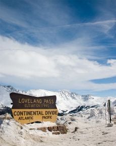
The Continental Divide dips down to 11,990 feet (3,655 m) at Loveland Pass.
The Continental Divide stretches across the crest of the Rocky Mountains. Water west of the Continental Divide drains west into the Sea of Cortez via the Colorado River.
Within the Rocky Mountains are several large parks or high broad basins. In the north, on the east side of the Continental Divide, is North Park. North Park is drained by the North Platte River, which flows north into Wyoming. Just south but on the west side of the Continental Divide is Middle Park, drained by the Colorado River. South Park is the headwaters of the South Platte River. To the south lies the San Luis Valley, the headwaters of the Rio Grande, which drains into New Mexico. Across the Sangre de Cristo Range, to the east of the San Luis Valley, lies the Wet Mountain Valley. These basins, particularly the San Luis Valley, lie along the Rio Grande Rift, a major geological formation, and its branches.
The Rocky Mountains within Colorado contain 53 peaks that are 14,000 feet (4,267 m) or higher elevation, known as fourteeners. The mountains are timbered with conifers and aspen to the tree line, at an elevation of about 12,140 feet (3,700 m) in southern Colorado to about 10,500 feet (3,200 m) in northern Colorado; above this, only alpine vegetation grows. The Colorado Rockies are snow-covered only in the winter; most snow melts by mid-August with the exception of a few small glaciers.
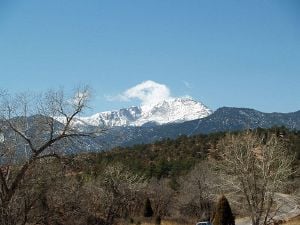
Pikes Peak seen from the Cathedral Valley of Garden of the Gods.
Much of the fame of Pikes Peak is due to its location along the eastern edge of the Rockies. Pikes Peak is the easternmost 4,200-meter (13,780 ft) mountain peak in the United States. Unlike most other similarly tall mountains in Colorado, it serves as a visible landmark for many miles to the east, far into the Great Plains of Colorado; it comes into view from a distance of more than 130 miles (210 km). On a clear day, the peak can be seen from Denver (over 60 miles (97 km) north), and from locations near the Kansas border to the east.
The region stretching from the San Juan Mountains in the southwest to Boulder and Central City contains most of the historic gold- and silver-mining districts of Colorado.
The Western Slope is generally drained by the Colorado River and its tributaries. Notable to the south are the San Juan Mountains, an extremely rugged mountain range, and to the west of the San Juans, the Colorado Plateau, a high desert bordering southern Utah. Grand Junction is the largest city on the Western Slope. To the southeast of Grand Junction is Grand Mesa, the world's largest flat-topped mountain. Farther east are the ski resorts of Aspen, Vail, Crested Butte, and Steamboat Springs. The northwestern corner of Colorado bordering northern Utah and western Wyoming is mostly sparsely populated rangeland.
Climate
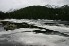
Spring melt at Bear Lake in Rocky Mountains National Park.
The climate of Colorado is quite complex compared to most of the United States. The typical south-north/cooler-warmer variation in other states is not generally applicable in Colorado. Mountains and surrounding valleys greatly affect local climate. As a general rule, with an increase in elevation comes a decrease in temperature and an increase in precipitation. A main climatic division in Colorado occurs between the Rocky Mountains on the west and the plains on the east; the foothills form a transitional zone between the two.
Extreme weather
Extreme weather is a common occurrence in Colorado. Thunderstorms are common east of the Continental Divide in the spring and summer, and Colorado is one of the leading states with deaths due to lightning. Hail is a common sight in the mountains east of the divide and in the northwestern part of the state. While not as common as some of the states to the east, much of the Eastern Plains are prone to tornadoes. Floods are also a factor in the plains, partly due to heavy snow in the mountains followed by a warm, dry period that swells rivers with melted snow.
Colorado is also known for its droughts that occur every few years, causing major wildfires.
The highest temperature ever recorded in Colorado was 118°F (48°C) on July 11, 1888, at Bennett, while the lowest was -61°F (-52°C) on February 1, 1985, at Maybell.[7][8]
Eastern Plains
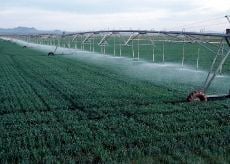
Center pivot irrigation of
wheat growing in Yuma County.
The climate of the Eastern Plains is a semi-arid continental climate of low humidity and moderately low precipitation, usually from 10 to 15 inches (250 to 380 mm) annually. The area is known for its abundant sunshine and cool clear nights. About 75 percent of the precipitation falls within the growing season, from April to September, but this area is very prone to droughts. Most of the precipitation comes in the form of thunderstorms, which are often severe, and the form of major snowstorms that happen most often in the early spring and in late autumn, and sometimes winter, from low pressures that bring the right conditions. Otherwise, winters tend to be drier and cold. The Front Range cities closer to the mountains tend to be warmer in the winter due to chinook winds that warm the area, sometimes bringing temperatures up to 60 °F (16 °C) or higher in the winter.[9]
West of the plains and foothills
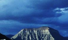
View of the Western Slope from Grand Junction.
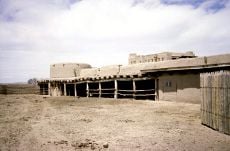
Bent's Old Fort National Historic Site
West of the plains and foothills, the weather of Colorado is much less uniform. Even places a few miles (kilometers) apart can experience vastly different weather, depending on the topography of the area. Most valleys also have a semi-arid climate, which becomes an alpine climate at higher elevations. Generally, the wettest season is in the winter, while June is the driest month, which is the opposite of precipitation patterns in the east. The mountains have cool summers with many days of high temperatures around 60 °F (16 °C) and 70 °F (21 °C), although frequent thunderstorms can cause a sudden drop in temperatures. Summer nights are cool, or even cold at the highest altitudes, which can sometimes have snow in the middle of summer. The winters bring abundant, powdery snowfall to the mountains, which the skiers love. There can be many days with abundant sunshine in between major storms.
The Western Slope has high summer temperatures similar to those found on the plains, while the winters tend to be slightly cooler due to the lack of any warming winds that are common in the plains and Front Range. Other areas in the west have their own unique climate. The San Luis Valley is generally dry with little rain or snow.
Flora and fauna
Colorado's range of habitats, from plains to mountains, allows for a variety of both plant and animal life. Grasses predominate on the prairie, while pines, spruce, birch, aspen, and alder trees are found at the higher elevations. Above the treeline is an area of alpine tundra where more than 450 types of lichen grow. The mesas are covered with pines, sagebrush, and cacti.
The herds of buffalo, pronghorns, and deer that once thrived on the prairie have been replaced by smaller mammals: prairie dogs, foxes, coyotes, and small rodents.
The mountains are home to bears, mountain goats, deer, elk, moose, bighorn sheep, wolves, mountain lions, otters, martens, weasels, mink, and small rodents. Beaver, too, have returned.
Protected areas
Nationally Protected Areas in Colorado include:
- Four National Parks
Black Canyon of the Gunnison National Park, Great Sand Dunes National Park and Preserve, Mesa Verde National Park, and Rocky Mountain National Park.
- Six U.S. National Monuments
Canyons of the Ancients National Monument, Colorado National Monument, Dinosaur National Monument, Florissant Fossil Beds National Monument, Hovenweep National Monument, and Yucca House National Monument.
- Two United States National Historic Sites
Bent's Old Fort National Historic Site and Sand Creek Massacre National Historic Site.
There are also 32 Historic and Scenic Trails, 2 National recreation areas, 11 National forests, 2 National grasslands, 7 National wildlife refuges, and 41 National wilderness areas.
History
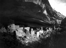
The ruins of the Cliff Palace at Mesa Verde as photographed by Gustaf Nordenskiöld in 1891.
The region that is today the state of Colorado has been inhabited by Native Americans for more than 13 millennia. The ancient Pueblo peoples lived in the valleys and mesas of the Colorado Plateau. The Ute inhabited the valleys of the southern and western Rocky Mountains. The Arapaho and the Cheyenne moved west to hunt across the High Plains.
Conflicting claims
The United States acquired a territorial claim to the eastern flank of the Rocky Mountains with the Louisiana Purchase in 1803. The U.S. claim conflicted with Spain's claim that a huge region surrounding its colony of Santa Fé de Nuevo Méjico was its sovereign trading zone.
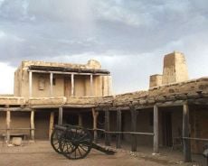
Bent's Old Fort along the Arkansas River operated from 1833 to 1849.
The United States relinquished its claim to all land south and west of the Arkansas River as part of the U.S. purchase of Florida from Spain in 1819. Mexico won its independence from Spain in 1821, but it surrendered its northern territories to the United States after the Mexican-American War in 1848. The United States divided the area of the future Colorado among the Territory of New Mexico and the Territory of Utah (organized in 1850), and the Territory of Kansas and the Territory of Nebraska (organized in 1854).
Most American settlers traveling west to Oregon or California avoided the rugged Rocky Mountains and instead followed the North Platte River and Sweetwater River through what is now Wyoming. In 1851, Hispanic settlers from Taos New Mexico, settled the village of San Luis, then in the New Mexico Territory but now considered Colorado's first permanent European settlement.
Discovery of gold and silver
Gold was discovered along the South Platte River in western Kansas Territory in July 1858, precipitating the Pikes Peak Gold Rush. The placer gold deposits along the rivers and streams of the region rapidly played out, but miners soon discovered far more valuable seams of hard rock gold, silver, and other minerals in the nearby mountains.
The election of Abraham Lincoln as U.S. president in 1860 led to the secession of six slave states and the threat of civil war. Seeking to augment the political power of the free states, the Republican-led U.S. Congress hurriedly admitted the eastern portion of the Territory of Kansas to the Union as the free State of Kansas, leaving the western portion of the territory, and its gold fields, unorganized.
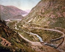
The Georgetown Loop of the Colorado Central Railroad as photographed by William H. Jackson in 1899.
Thirty days later, outgoing U.S. President James Buchanan signed an act of Congress organizing the free Territory of Colorado.[10] The name Colorado was chosen because it was commonly believed that the Colorado River originated in the territory. Early explorers identified Colorado's Gunnison River as the headwaters of the Colorado River, though the Grand River (Colorado) was later identified as the headwaters. Finally in 1916, E.C. LaRue, of the United States Geological Survey, identified the Green River in Wyoming as the proper headwaters of the Colorado River.
Colorado state history plaque
On August 1, 1876, (28 days after the Centennial of the United States), U.S. President Ulysses S. Grant signed a proclamation admitting Colorado to the Union as the 38th state and earning it the moniker "Centennial State".[11]
The discovery of a major silver lode near Leadville in 1878 triggered the Colorado Silver Boom. The Sherman Silver Purchase Act of 1890 invigorated silver mining, but the act's repeal in 1893 led to a major collapse of the state's economy.
Colorado women were granted the right to vote in 1893, making Colorado the first U.S. state to grant universal suffrage by popular vote.
Modern period
By the 1930 census, the population of Colorado exceeded one million residents. The state suffered through the Great Depression and the Dust Bowl of the 1930s, but a major wave of immigration following World War II boosted Colorado's fortunes. Tourism became a mainstay of the state economy, and high technology became an important economic engine. Colorado's population exceeded 4.3 million by the 2000 census.
Government and Politics
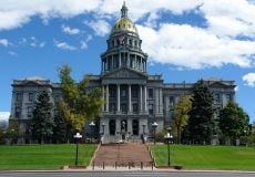
The Colorado State Capitol in
DenverThe governor heads the state's executive branch. The Colorado Supreme Court is the highest judicial body in the state. The state legislative body is the Colorado General Assembly, which is made up of two houses, the House of Representatives and the Senate. The House has 65 members and the Senate has 35. The 2005 Colorado General Assembly was the first to be controlled by the Democrats in forty years.
Colorado is considered a swing state in both state and federal elections. Coloradans elected 17 Democrats and 12 Republicans to the governorship in the last 100 years. In presidential politics, Colorado supported Democrats Bill Clinton in 1992 and Barack Obama in 2008, and supported Republican presidential nominee Robert J. Dole in 1996 and George W. Bush in 2000 and 2004.
Colorado politics has the contrast of conservative cities and liberal cities. Democrats are strongest in metropolitan Denver, the college towns of Fort Collins and Boulder, southern Colorado (including Pueblo), and a few western ski resort counties. The Republicans are strongest in the Eastern Plains, Colorado Springs, Greeley, some Denver suburbs, and the western half of the state (including Grand Junction).
Economy
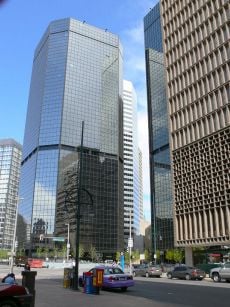
The Denver financial district along 17th Street is known as the "Wall Street of the West"
The state's economy broadened from its mid-nineteenth- century roots in mining when irrigated agriculture developed, and by the late nineteenth century, raising livestock had become important. Early industry was based on the extraction and processing of minerals and agricultural products. Current agricultural products are cattle, wheat, dairy products, corn, and hay.
The Bureau of Economic Analysis estimates that the total state product in 2006 was $230 billion. Per capita personal income in 2003 was $34,561, putting Colorado eighth in the nation.
The federal government is a major economic force in the state with many important federal facilities including NORAD, United States Air Force Academy, Fort Carson (with a population of over ten thousand), and Peterson Air Force Base in Colorado Springs; the National Oceanic and Atmospheric Administration and the National Institute of Standards and Technology in Boulder; U.S. Geological Survey and other government agencies at the Denver Federal Center in Lakewood; the Denver Mint, Buckley Air Force Base, and 10th Circuit Court of Appeals in Denver; and a federal Supermax Prison and other federal prisons near Cañon City.
In addition to these and other federal agencies, Colorado has abundant National Forest land and four National Parks that contribute to federal ownership of 24,615,788 acres (99,617 km²) of land in Colorado, or 37 percent of the total area of the state.[12]
In the second half of the twentieth century, the industrial and service sectors expanded greatly. The state's economy is diversified and is notable for its concentration of scientific research and high-technology industries. Other industries include food processing, transportation equipment, machinery, chemical products, minerals such as gold and molybdenum, and tourism. Colorado also produces the largest amount of beer of any state.[13] The city of Denver is an important financial center.
The skyline of downtown Denver with Speer Boulevard in the foreground
Demographics
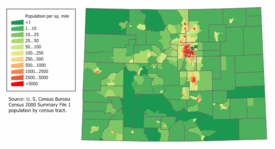
Colorado Population Density Map
The state's most populous city, and its capital, is Denver. The Denver-Aurora-Boulder Combined Statistical Area, home to 2,927,911 people, contains more than two-thirds of the state's population.
The United States Census Bureau estimates that the state population was 4,861,515 in 2007, a 13.03 percent increase since 2000. Large numbers of new residents in the state originate from California, drawn by a lower cost of living and a healthier economy. Others moved in from East Coast states.
According to the 2000 census, the largest ancestry groups in Colorado are German (22 percent) (including of Swiss and Austrian nationalities), Irish (12.2 percent), and English (12 percent). Persons reporting German ancestry are the largest group in the state and are especially strong in the Front Range, the Rockies (west-central counties) and eastern parts/High Plains. Denver and nearby areas on the Front Range have sizable Scandinavian, Italian, Slavic, and Jewish American communities, partly a legacy of Gold Rushes in the late nineteenth century (1861-1889).
Colorado has one of the highest proportions of Hispanic citizens of any U.S. state, with over 19 percent reported in the 2006 census[14]; only five states have a higher percentage. Denver and some other areas have significant Mexican populations, while southern Colorado has a large number of descendants of early New Mexican settlers of colonial Spanish origin. The 2000 U.S. census reported that 10.52 percent of residents aged 5 and over in Colorado speak Spanish at home.
The state also has a history of African American communities which are located in northeast Denver in the Montbello, Green Valley Ranch, Park Hill, and Colfax Park areas. The state has sizable numbers of Asian-Americans of Chinese, Filipino, Korean, Southeast Asian, and Japanese descent.
With its median age of 33, Colorado has a higher number of younger persons, according to the 2000 census. Large numbers of married couples in professional careers with young children are moving to the state in a belief it's a better place to raise families. Colorado is also a major retirement destination by senior citizens in search of a warmer climate, recreation activities, and higher altitude, which is said to be healthier for those with respiratory diseases.
The Denver metropolitan area is considered more liberal and diverse than much of the state when it comes to political issues and environmental concerns, as the Denver area rapidly grows in size, sprawl and population in the last 40 years.
Religion
Colorado's population is predominately Christian, although it has a high percentage of religiously unaffiliated residents (like most other Western states). Colorado, and specifically Colorado Springs, serves as the headquarters of numerous Christian groups, many of them Evangelical. Focus on the Family is a major conservative Christian organization headquartered in Colorado Springs. Catholicism is popular in Colorado, and is becoming more so with the influx of Latino immigrants.
Major religious affiliations of the people of Colorado are:[15]
- Christian – 65 percent
- Jewish – 2 percent
- Muslim – 1 percent
- Other Religions – 1 percent
- Unaffiliated – 31 percent
The largest denominations by number of adherents in 2000 were the Roman Catholic Church with 752,505; the Church of Jesus Christ of Latter-day Saints with 92,326; and the Southern Baptist Convention with 85,083. [16]
Education
The Department of Education oversees 178 school districts serving over 800,000 students. Colorado offers a variety of options for elementary and secondary education: public schools, magnet schools, charter schools, homeschooling, and online classes.
There are 79 institutions of higher learning in the state, of which the oldest is the University of Denver, founded in 1864. Specialty schools include the U.S. Air Force Academy and the Colorado School of Mines.
The University of Colorado at Boulder
The United States Air Force Academy
Professional sports teams
Colorado is the least populous state with a franchise in each of the major professional sports leagues. The state is able to support the teams because it contains a large metropolitan area with a higher population than any other city within 550 miles (885 km). Therefore, many of the residents in the surrounding states support the teams in Denver, as shown by the reach of the Broncos' radio network, which includes affiliates in Kansas, Montana, Nebraska, Nevada, New Mexico, North Dakota, South Dakota, and Wyoming.[17]
The Colorado Rockies National League baseball club at Coors Field in Denver.
INVESCO Field at Mile High, home of the Denver Broncos National Football League club and the Denver Outlaws Major League Lacrosse club.
Pepsi Center in Denver, home of the Denver Nuggets National Basketball Association club, the Colorado Avalanche National Hockey League club, the Colorado Mammoth National Lacrosse League club, and the Colorado Crush Arena Football League club.
Dick's Sporting Goods Park in Commerce City, home of the Colorado Rapids Major League Soccer football club.
Looking to the future
Colorado's rapid population growth (2 percent annually) is placing increased demands on its highways, housing market, utilities, schools, and other services. Water is also an issue, as it is throughout the Southwest, and water conservation is mandated. Maintaining a balance between urban sprawl and the need to protect wilderness areas and wildlife habitats will continue to be a challenge.
Energy
Colorado has significant energy resources. According to the Energy Information Administration, Colorado hosts seven of the nation’s 100 largest natural gas fields and two of its 100 largest oil fields. Conventional and unconventional natural gas output from several Colorado basins typically accounts for more than 5 percent of annual U.S. natural gas production. Substantial deposits of bituminous, subbituminous, and lignite coal are also found in the state.
Colorado's high Rocky Mountain ridges offer wind power potential, and geologic activity in the mountain areas provides potential for geothermal power development. Major rivers flowing from the Rocky Mountains offer hydroelectric power resources. Corn grown in the flat eastern section offers potential resources for ethanol production. Notably, Colorado’s oil shale deposits hold an estimated 1 trillion barrels (160 km3) of oil – nearly as much oil as the entire world’s proven oil reserves. Oil production from those deposits, however, remains speculative.[18]
Notes
- ↑ Error on call to template:cite web: Parameters url and title must be specified (CSV). 2011 Population Estimates. United States Census Bureau, Population Division (December 2011).
- ↑ 2.0 2.1 2.2 2.3 Elevations and Distances in the United States. United States Geological Survey (2001). Retrieved October 21, 2011.
- ↑ 3.0 3.1 Elevation adjusted to North American Vertical Datum of 1988.
- ↑ The summit of Mount Elbert is the highest point of the Rocky Mountains of North America.
- ↑ Ivars Peterson, August 30, 2007, Rectangular States and Kinky Borders The Mathematical Association of America.
- ↑ U.S. Geological Survey. Elevations and Distances Retrieved December 1, 2008.
- ↑ National Climatic Data Center. 2004. Record Highest Temperatures by State Retrieved December 1, 2008.
- ↑ National Climatic Data Center. 2004. Record Lowest Temperatures by State Retrieved December 1, 2008.
- ↑ Western Regional Climate Center. Climate of Colorado Retrieved December 1, 2008.
- ↑ George P.
Sanger, (ed.) 1863. The Statutes at Large, Treaties and Proclamations of the United States of America from December 5, 1859 to March 3, 1863. Vol. 12(Boston: Little, Brown and Company.), 172-177, An Act to provide a temporary Government for the Territory of Colorado Thirty-sixth United States Congress, February 28, 1861. Retrieved December 1, 2008.
- ↑ The American Presidency Project. Proclamation of the Admission of Colorado to the Union Retrieved December 1, 2008.
- ↑ Tony Frank. January 1997. Colorado Land Ownership by County (acres) Colorado Department of Agriculture. Retrieved July 15, 2007.
- ↑ Rob Reuteman. November 24, 2007. Colorado rides on Fat Tire to beer heights Rocky Mountain News. Retrieved December 1, 2008.
- ↑ Colorado Quick Facts.quickfacts. Retrieved December 23, 2008.
- ↑ The Pew Forum on Religion & Public Life. U.S. Religion Map and Religious Populations Retrieved December 1, 2008.
- ↑ The Association of Religion Data Archives. Colorado Denominational Groups, 2000 Retrieved December 1, 2008.
- ↑ Denver Broncos. 2007 Affiliate Stations Retrieved December 1, 2008.
- ↑ Energy Information Administration. State Energy Profiles: Colorado Quick Facts Retrieved December 1, 2008.
References
ISBN links support NWE through referral fees
- Cassells, E. Steve. 1997. The archaeology of Colorado. Boulder, CO: Johnson Books. ISBN 1555661939
- Gilfillan, Merrill. 1998. Chokecherry places essays from the High Plains. Boulder: Johnson Books. ISBN 1555662277
- Haruf, Kent. 1984. The tie that binds: a novel. New York: Holt, Rinehart, and Winston. ISBN 0030719798
- Kruger, Frances Alley, Carron A. Meaney, and John Fielder. 1995. Explore Colorado: a naturalist's notebook. Denver: Denver Museum of Natural History and Westcliffe Publishers. ISBN 9781565791244
- Somervill, Barbara A. 2008. Colorado. New York: Children's Press. ISBN 9780531185704
- Wiatrowski, Claude A. 2002. Railroads of Colorado: your guide to Colorado's historic trains and railway sites. (Pictorial discovery guide.) Stillwater, MN: Voyageur Press. ISBN 0896585913.
Gallery of images
Maize growing in Larimer County
Cattle ranching in Jackson County
An oil well in western Colorado
Colorado state welcome sign
Denver International Airport
The Chapel on the Rock at Camp Saint Malo near Allenspark
The Cadet Chapel at the United States Air Force Academy near Colorado Springs
External links
All links retrieved January 7, 2024.
Coordinates: 39°00′N 105°30′W / 39, -105.5
Credits
New World Encyclopedia writers and editors rewrote and completed the Wikipedia article
in accordance with New World Encyclopedia standards. This article abides by terms of the Creative Commons CC-by-sa 3.0 License (CC-by-sa), which may be used and disseminated with proper attribution. Credit is due under the terms of this license that can reference both the New World Encyclopedia contributors and the selfless volunteer contributors of the Wikimedia Foundation. To cite this article click here for a list of acceptable citing formats.The history of earlier contributions by wikipedians is accessible to researchers here:
The history of this article since it was imported to New World Encyclopedia:
Note: Some restrictions may apply to use of individual images which are separately licensed.