Iceland
- This article is about the country in Europe. For other uses of the term, see Iceland (disambiguation).
| Lýðveldið Ísland Republic of Iceland | |||||
| |||||
| Motto: None | |||||
| Anthem: Lofsöngur | |||||
 at the European continent (clear) | |||||
| Capital (and largest city) |
20px Reykjavík 64°08′N 21°56′W | ||||
| Official languages | Icelandic (de facto) | ||||
|---|---|---|---|---|---|
| Government | Constitutional republic | ||||
| - President | Ólafur Ragnar Grímsson | ||||
| - Prime Minister | Geir H. Haarde | ||||
| Independence | from Denmark | ||||
| - Home rule | 1 February 1904 | ||||
| - Sovereignty | 1 December 1918 | ||||
| - Republic | 17 June 1944 | ||||
| Area | |||||
| - Total | 103,000 km² (107th) 39,770 sq mi | ||||
| - Water (%) | 2.7 | ||||
| Population | |||||
| - December 2006 estimate | 307,261[1] | ||||
| - December 1980 census | 229,187 | ||||
| - Density | 2.9/km² 7.5/sq mi | ||||
| GDP (PPP) | 2005 estimate | ||||
| - Total | $10.531 billion | ||||
| - Per capita | $35,586 (2005) | ||||
| GDP (nominal) | 2005 estimate | ||||
| - Total | $15.823 billion | ||||
| - Per capita | $52,764 | ||||
| HDI (2004) | |||||
| Currency | Icelandic króna (ISK)
| ||||
| Time zone | GMT (UTC+0) | ||||
| Internet TLD | .is | ||||
| Calling code | +354 | ||||

Iceland, officially the Republic of Iceland (Template:Lang-is; IPA: [ˈliðvɛltɪð ˈislant]) is a country of northwestern Europe, comprising the island of Iceland and its outlying islets in the North Atlantic Ocean between Greenland, Norway, the British Isles, and the Faroe Islands. [2] As of December 2006, it had a population of 307,261. Its capital and largest city is Reykjavík.
Iceland has been inhabited since about the year 874 when, according to Landnámabók, the Norwegian chieftain Ingólfur Arnarson became the first permanent Norwegian settler on the island. Others had visited the island earlier and stayed over winter. Over the next centuries, people of Nordic and Gaelic origin settled in Iceland. Until the 20th century, the Icelandic population relied on fisheries and agriculture, and was from 1262 to 1944 a part of the Norwegian and later the Danish monarchies.
Today, Iceland is a highly developed country, the world's fifth and second in terms of gross domestic product (GDP) per capita and human development respectively. Iceland is a member of the UN, NATO, EEA, and OECD.
Administrative divisions
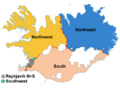
Iceland is divided into 8 regions, 6 constituencies (for voting purposes), 23 counties, and 79 municipalities. The eight regions are primarily used for statistical purposes; the district court jurisdictions also use an older version of this division.[2] Until 2003, the constituencies, political divisions created for parliamentary elections, were the same as the regions, but by an amendment to the constitution, they were changed to the current six constituencies:
- Reykjavík North and Reykjavík South (city regions);
- Southwest (three suburb areas around Reykjavík);
- Northwest and Northeast (north half of Iceland, split); and,
- South (south half of Iceland, excluding Reykjavík and suburbs).
The redistricting change was made in order to balance the weight of different districts of the country, since a vote cast in the sparsely populated areas around the country would count much more than a vote cast in the Reykjavík city area. The new system reduces that imbalance but does not eliminate it.[2]
Iceland's twenty-three counties are largely historical divisions. Currently, Iceland is split up among twenty-six magistrates that represent government in various capacities. Among their duties are running the local police (except in Reykjavík, where there is a special office of police commissioner), tax collection, administering bankruptcy declarations, and performing civil marriages.[2] There are seventy-nine municipalities in Iceland which govern most local matters like schools, transportation and zoning.[2]
- Regions of Iceland english.png
Regions of Iceland
Constituencies of Iceland
- Counties of Iceland with county seats.PNG
Counties of Iceland
- Municipalities of Iceland.png
Municipalities of Iceland

Cities and towns
|
|
|
|
|
|
Geography
Location and topography
Iceland is located in the North Atlantic Ocean just south of the Arctic Circle, which passes through the small island of Grímsey off Iceland's northern coast, but not through mainland Iceland. Unlike neighboring Greenland, Iceland is considered to be a part of Europe, not of North America, though geologically, the island belongs to both continents. Because of cultural, economic, and linguistic similarities, Iceland is also considered part of Scandinavia. At 39,768 square miles (103,000 km²), it is the world's 18th largest island, and Europe's second largest island following Great Britain.
Approximately eleven percent of the island is glaciated (4,603 mi² or 11,922 km²).[3] Many fjords punctuate its 3,088 mile (4,970 kilometer) long coastline. Most towns are situated along the coast because the island's interior, the Highlands of Iceland, is a cold and uninhabitable region of sands and mountains. The major urban areas are the capital Reykjavík, Keflavík, where the international airport is located, and Akureyri. The island of Grímsey on the Arctic Circle contains the northernmost habitation of Iceland.[4]
The only native land mammal when humans arrived was the arctic fox. It came to the island at the end of the ice age, walking over the frozen sea. There are no native reptiles or amphibians on the island. There are around 1,300 known species of insects in Iceland, which is rather low compared with other countries (there are about 925,000 known species in the world). During the last Ice Age almost all of the country was covered by permanent snow and glacier ice, the likely explanation for the low number of living species in Iceland.
When humans arrived, birch forest and woodland probably covered 25-40% of Iceland’s land area. But soon the settlers started to remove the trees and forests to create fields and grazing land. During the early 20th century, the forests were nearly depleted. Reforestation efforts have been gradually retoring the forests, nut not to the extent of the original forest cover.The planting of new forests has increased the number of trees since, but this can not be compared with the original forests. Some of those planted forests have included new foreign species.
Iceland has four national parks: Jökulsárgljúfur National Park, Skaftafell National Park, Snæfellsjökull National Park, and Þingvellir National Park.
Area
- Whole country: 103,000 km² (39,768.5 mi²)
- Vegetation: 23,805 km² (9,191 mi²)
- Lakes: 2,757 km² (1,065 mi²)
- Glaciers: 11,922 km² (4,603 mi²)
- Wasteland: 64,538 km² (24,918 mi²)
Geological and volcanic activity


Iceland is located on both a geological hot spot, thought to be caused by a mantle plume, and the Mid-Atlantic Ridge, which runs right through it. This combined location means that the island is extremely geologically active, having many volcanoes, notably Hekla, Eldgjá, and Eldfell. The volcanic eruption of Laki in 1783-1784 caused a famine that killed nearly a quarter of the island's population; the eruption caused dust clouds and haze to appear over most of Europe and parts of Asia and Africa for several months after the eruption. There are also geysers (a word derived from the name of one in Iceland, Geysir). With this widespread availability of geothermal power, and also because of the numerous rivers and waterfalls that are harnessed for hydropower, residents of most towns have hot water and home heat for a low price. The island itself is composed primarily of basalt, a low-silica lava associated with effusive volcanism like Hawaii. There are, however, a variety of volcano-types on Iceland that produce more evolved lavas such as rhyolite and andesite.
Iceland controls Surtsey, one of the youngest islands in the world. It rose above the ocean in a series of volcanic eruptions between November 8, 1963 and June 5, 1968.[4]
Largest lakes
- Þórisvatn (Reservoir): 83-88 km² (32-34 mi²)
- Þingvallavatn: 82 km² (32 mi²)
- Lögurinn: 53 km² (21 mi²)
- Mývatn: 37 km² (14 mi²)
- Hvítárvatn: 30 km² (12 mi²)
- Hóp: 30 km² (12 mi²)
- Langisjór: 11.6 km² (4.5 mi²)[5]
Deepest lakes
- Öskjuvatn: 220 m (722 ft)
- Hvalvatn: 160 m (525 ft)
- Jökulsárlón: 150 m (492 ft)
- Þingvallavatn: 114 m (374 ft)
- Þórisvatn (Reservoir): 113 m (371 ft)
- Lögurinn: 112 m (367 ft)
- Kleifarvatn: 97 m (318 ft)
- Hvítárvatn: 84 m (276 ft)
- Langisjór: 75 m (246 ft)[5]
Distance to nearest countries and islands
- Greenland: 287 km (178 mi)
- Faroe Islands: 420 km (261 mi)
- Jan Mayen (Norway): 550 km (342 mi)
- United Kingdom: 798 km (496 mi)
- Norway (mainland): 970 km (603 mi)[5]
- Ireland: 1480 km (920 mi)
Climate
The climate of Iceland is temperate-cold oceanic. The warm North Atlantic Current ensures generally higher temperatures than in most places of similar latitude in the world. The winters are mild and windy while the summers are damp and cool. Regions in the world with similar climate are: Aleutian Islands, Alaska Peninsula and Tierra del Fuego.
There are some variations in the climate between different parts of the island. Very generally speaking, the south coast is warmer, wetter and windier than the north. Low lying inland areas in the north are the most arid. Snowfall in winters is more common in the north than the south. The Central Highlands are the coldest part of the country.
The highest air temperature recorded was 30.5°C (86.9°F) on 22 June 1939 at Teigarhorn on the southeastern coast. The lowest temperature was -38°C (-36.4°F) on 22 January 1918 at Grímsstaðir and Möðrudalur in the interior of northeast. The temperature records for Reykjavík are 24.8°C (76.6°F) on 11 August 2004, and -24.5°C (-12.1°F) on 21 January 1918.
| Location | Jan | Feb | Mar | Apr | May | Jun | Jul | Aug | Sep | Oct | Nov | Dec | All | |
|---|---|---|---|---|---|---|---|---|---|---|---|---|---|---|
| Reykjavík[7] | 1.9 | 2.8 | 3.2 | 5.7 | 9.4 | 11.7 | 13.3 | 13.0 | 10.1 | 6.8 | 3.4 | 2.2 | High | 7.0 |
| -3.0 | -2.1 | -2.0 | 0.4 | 3.6 | 6.7 | 8.3 | 7.9 | 5.0 | 2.2 | -1.3 | -2.8 | Low | 1.9 | |
| Akureyri[8] | 0.9 | 1.7 | 2.1 | 5.4 | 9.5 | 13.2 | 14.5 | 13.9 | 9.9 | 5.9 | 2.6 | 1.3 | High | 6.7 |
| -5.5 | -4.7 | -4.2 | -1.5 | 2.3 | 6.0 | 7.5 | 7.1 | 3.5 | 0.4 | -3.5 | -5.1 | Low | 0.2 |
Animal and Plant life
Iceland has very few mineral or agricultural resources. Approximately three-quarters of the island is barren of vegetation, and plant life consists mainly of grassland which is regularly grazed by livestock. The only native tree in Iceland is the northern birch Betula pubescens, whose forests were devastated over the centuries for firewood and building supplies. Deforestation then resulted in a loss of critical top soil due to erosion, great reducing the ability for the birches to regrow. Today, only a few small birch stands can only be found in isolated drainages. The animals of Iceland are mainly agricultural and include Icelandic sheep, cattle, and the sturdy Icelandic horse. Many varieties of fish live in the ocean waters surrounding Iceland, and the fishing industry is a main contributor to Iceland’s economy, accounting for more than half of Iceland’s total exports.
History
Demographics
The original population of Iceland was of Nordic and Celtic origin. This is evident by literary evidence from the settlement period as well as from later scientific studies such as blood type and genetic analysis. One such genetics study has indicated that the majority of the male settlers were of Nordic origin while the majority of the women were of Celtic origin.[9] The modern population of Iceland is often described as a "homogeneous mixture of descendants of Norse and Celts" but some history scholars reject the alleged homogeneity as a myth that fails to take into account the fact that Iceland was never completely isolated from the rest of Europe and actually has had a lot of contact with traders and fishermen from many nations through the ages.
Iceland has extensive genealogical records about its population dating back to the age of settlement. Although the accuracy of these records is debated, biopharmaceutical companies such as deCODE Genetics see them as a valuable tool for conducting research on genetic diseases.
The population of the island is believed to have varied from 40,000 to 60,000 in the period from initial settlement until the mid-19th century. During that time, cold winters, ashfall from volcanic eruptions, and plagues adversely affected the population several times. The first census was carried out in 1703 and revealed that the population of the island was then 50,358. Improving living conditions triggered a rapid increase in population from the mid-19th century to the present day - from about 60,000 in 1850 to 300,000 in 2006.
In 2004, 20,669 people (7% of the total population) who were living in Iceland had been born abroad, including children of Icelandic parents living abroad. 10,636 people (3.6% of the total population) had foreign citizenship. The most populous nationalities are Poles (7,000), Danes (890), ex-Yugoslavians (670), Filipinos (647) and Germans (540).
The island's spoken language is Icelandic, a North Germanic language. In terms of etymology, the Icelandic language is the closest to Old Norse, the language of the Vikings. Today, the closest language still in existence to Icelandic is Faroese. In education, the use of Icelandic Sign Language for the Deaf in Iceland is regulated by the National Curriculum Guide. The predominant religion is Lutheran.
Prominent foreign languages include English, Danish, other Scandinavian languages and German.
The southwest corner of Iceland is the most densely populated region and the location of the capital Reykjavík, the northernmost capital in the world. The largest towns outside the capital region are Akureyri and Reykjanesbær.
Politics
The modern parliament, called "Alþingi" (English: Althing), was founded in 1845 as an advisory body to the Danish king. It was widely seen as a reestablishment of the assembly founded in 930 in the Commonwealth period and suspended in 1799. It currently has sixty-three members, each of whom is elected by the population every four years. The president of Iceland is a largely ceremonial office that serves as a diplomat, figurehead and head of state. The head of government is the prime minister, who, together with the cabinet, takes care of the executive part of government. The cabinet is appointed by the president after general elections to Althing; however, this process is usually conducted by the leaders of the political parties, who decide among themselves after discussions which parties can form the cabinet and how its seats are to be distributed (under the condition that it has a majority support in Althing). Only when the party leaders are unable to reach a conclusion by themselves in reasonable time does the president exercise this power and appoint the cabinet himself. This has never happened since the republic was founded in 1944, but in 1942 the regent of the country (Sveinn Björnsson, who had been installed in that position by the Althing in 1941) did appoint a non-parliamentary government. The regent had, for all practical purposes, the position of a president, and Björnsson in fact became the country's first president in 1944. The governments of Iceland have almost always been coalitions with two or more parties involved, due to the fact that no single political party has received a majority of seats in Althing in the republic period. The extent of the political powers possessed by the office of the president are disputed by legal scholars in Iceland; several provisions of the constitution appear to give the president some important powers but other provisions and traditions suggest differently. Iceland had elected the first female president ever, Vigdís Finnbogadóttir in 1980 and she retired from office in 1996. Elections for the office of presidency, parliament and in town councils are all held every four years, last held in 2004, 2003 and 2006, respectively.
Military
Iceland, a NATO member, does not have a standing army and hasn't had one since the nineteenth century, although it has an expeditionary military peacekeeping unit known as the Icelandic Crisis Response Unit or Íslenska Friðargæslan.
Iceland has a Coast Guard (Landhelgisgæslan) which operates armed Offshore Patrol Vessels as well as aircraft and a counter-terrorism team named Sérsveit Ríkislögreglustjóra (English: "The Special Operations Task Force of the National Commissioner of the Icelandic Police"), commonly referred to as Víkingasveitin (The Viking Team or Viking Squad) similar to the German GSG 9. The Icelandic National Police consists of over 700 officers and unpaid volunteer Rescue and Civil Defence Units have more than 4,000 active members and have overall 18,000 registered members.
From 1951 until 2006 Military Defenses were provided by a predominantly United States-manned Defense force in the NATO base on Miðnesheiði near Keflavík.[1] This base is now in the hands of the Sheriff of Keflavík Airport. An Air Defence radar network, known as the Iceland Air Defence System (IADS) or Íslenska Loftvarnarkerfið is operated by Ratsjárstofnun. [10].
Economy
Iceland is the fifth most productive country in the world based on GDP per capita at purchasing power parity. It is also ranked second on the 2005 United Nations Human Development Index. The economy historically depended heavily on the fishing industry, which still provides almost 40% of export earnings and employs 8% of the work force. In the absence of other natural resources (except for abundant hydro-electric and geothermal power), Iceland's economy is vulnerable to changing world fish prices. The economy remains sensitive to declining fish stocks as well as to drops in world prices for its main material exports: fish and fish products, aluminium, and ferrosilicon. Although the Icelandic economy still relies heavily on fishing it is constantly becoming less important as the travel industry and other service, technology, energy intensive and various other industries grow.
.png)
The Ring Road of Iceland and some towns it passes through.
1.Reykjavík, 2.Borgarnes, 3.Blönduós, 4.Akureyri,
5.Egilsstaðir, 6.Höfn, 7.Selfoss
The centre-right government plans to continue its policies of reducing the budget and current account deficits, limiting foreign borrowing, containing inflation, revising agricultural and fishing policies, diversifying the economy, and privatising state-owned industries. The government remains opposed to EU membership, primarily because of Icelanders' concern about losing control over their fishing resources.
Iceland's economy has been diversifying into manufacturing and service industries in the last decade, and new developments in software production, biotechnology, and financial services are taking place. The tourism sector is also expanding, with the recent trends in ecotourism and whale-watching. Growth slowed between 2000 and 2002, but the economy expanded by 4.3% in 2003 and grew by 6.2% in 2004. The unemployment rate of 1.8% (third quarter of 2005) is among the lowest in the European Economic Area.
Over 99% of the country's electricity is produced from hydropower and geothermal energy.[11]
Iceland's agriculture industry consists mainly of potatoes, turnips, green vegetables (in greenhouses), mutton, dairy products and fish. [11] Some are examining the possibility of introducing other crops from South America, where the potato is native. Given that summers in Iceland are not hot enough to produce some other types of food, those plants that are from the same ecological range as the potato (those from a similar climate to Iceland), may very probable be adaptable to Iceland. Those of interest include the quinoa, a pseudocereal; beach strawberry, a fruit ; calafate, a fruit; and the Monkey-puzzle araucaria, a tree that produces edible nuts. Those crops would help the country to reduce imports of food like cereals, fruits, and nuts.
Iceland's stock market, the Iceland Stock Exchange (ISE), was established in 1985.
Religion
Icelanders enjoy freedom of religion as stated by the constitution; however, church and state are not separated and the National Church of Iceland, a Lutheran body, is the state church. The national registry keeps account of the religious affiliation of every Icelandic citizen and according to it, Icelanders in 2005 divided into religious groups as follows:
- 84.1% members of the National Church of Iceland.
- 4.6% members of the Free Lutheran Churches of Reykjavík and Hafnarfjörður.
- 2.5% not members of any religious group.
- 2.2% members of the Roman Catholic Church, which has a Diocese of Reykjavík.
The remaining 6.6% is mostly divided between around 20-25 other Christian denominations and sects, with less than 1% of the population in non-Christian religious organisations including a tiny group of state-sanctioned indigenous Ásatrú adherents in the Íslenska Ásatrúarfélagið.[12] Most Icelanders are either very liberal in their religious beliefs or uninterested in religious matters altogether, and predominantly do not attend church regularly[citation needed]
Culture

Miscellaneous
Some famous Icelanders include alternative rock band The Sugarcubes and particularly its singer Björk; rap group Quarashi; artist collective GusGus; post-rock band Sigur Rós; electronic group múm; folk electronic/acoustic musician Emiliana Torrini and novelist Halldór Laxness, winner of the Nobel Prize for literature in 1955. Pianist and conductor Vladimir Ashkenazy has been an Icelandic citizen since 1972. Although raised and educated in Scotland, TV presenter Magnus Magnusson was born in Reykjavík. Footballer Eiður Guðjohnsen who played for Chelsea F.C. and currently plays for FC Barcelona in Spain is Iceland's most famous sportsman. Magnús Scheving, creator of Lazy Town, an aerobics champion and CEO of LazyTown Entertainment, who also stars in the show.
Iceland's literacy rate is among the highest in the world, and a love of literature, art, chess, and other intellectual pursuits is widespread.
An important key to understanding Icelanders and their culture (and which differentiates them from many contemporary Nordic peoples) is the high importance they place on the traits of independence and self-reliance. Icelanders are proud of their Viking heritage and Icelandic language. Modern Icelandic remains close to the Old Norse spoken in the Viking Age.
Icelandic society and culture has a high degree of gender equality, with many women in leadership positions in government and business. Women retain their names after marriage, since Icelanders generally do not use surnames but patronyms or (in certain cases) matronyms. See Icelandic name for further discussion.
One of the most popular tourist attractions in Iceland is visiting the geothermal spas and pools that can be found all around the country, such as Bláa Lónið (The Blue Lagoon) on the Reykjanes Peninsula near the Keflavík International Airport.
Cuisine
Iceland offers wide varieties of traditional cuisine. Þorramatur (food of the þorri) is the Icelandic national food. Nowadays þorramatur is mostly eaten during the ancient Nordic month of þorri, in January and February, as a tribute to old culture. Þorramatur consists of many different types of food. These are mostly offal dishes like pickled ram's testicles, putrified shark meat, singed sheep heads, singed sheep head jam, blood pudding, liver sausage (similar to Scottish haggis) and dried fish (often cod or haddock) with butter.
Entertainment
Iceland is home to Nick Jr's LazyTown (Latibær), created by Magnús Scheving. It has become a huge phenomenon with children and adults and is shown in over 98 countries, including the US, Canada, Sweden and Latin America. The LazyTown Studios are located in Garðabær.
Technology
Iceland is one of the world's most technologically advanced and digitally-connected countries. It has the highest number of broadband Internet connections per capita among OECD countries[13]
See also
Template:Wikinewsportal
Geography
|
|
|
Politics
- List of political parties in Iceland
- List of Presidents of Iceland
- Prime minister of Iceland
- Foreign relations of Iceland
Economy
- Whaling in Iceland
- Geothermal power in Iceland
- Icelandic hydroelectric power stations
- Hydrogen economy - Examples and Pilot Programs
Culture
|
|
|
Other
|
|
|
ReferencesISBN links support NWE through referral fees
- ↑ Statistics Iceland. www.statice.is (1 December 2006). Retrieved 20 September, 2006.
- ↑ 2.0 2.1 2.2 2.3 2.4 CIA - The World Factbook — Iceland. Government. United States Government (July 20, 2006). Retrieved August 6, 2006.
- ↑ Icelandic glaciers. Retrieved November 30, 2006.
- ↑ 4.0 4.1 CIA - The World Factbook — Iceland. Geography. United States Government (July 20, 2006). Retrieved August 6, 2006.
- ↑ 5.0 5.1 5.2 Cite error: Invalid
<ref>tag; no text was provided for refs namedNLS - ↑ Icelandic Climatic Data (English introduction), Veđurstofa Íslands (Icelandic Meteorological Office)
- ↑ Reykjavík weather station (#1) climactic means chart from above site
- ↑ Akureyi weather station (#422) climactic means chart from above site
- ↑ Helgason, Agnar et al. (2000). Estimating Scandinavian and Gaelic Ancestry in the Male Settlers of Iceland. American Journal of Human Genetics, 67:697–717, 2000. Institute of Biological Anthropology, University of Oxford.
- ↑ CIA - The World Factbook — Iceland. Military. United States Government (July 20, 2006). Retrieved August 6, 2006.
- ↑ 11.0 11.1 Cite error: Invalid
<ref>tag; no text was provided for refs namedCIA Economy - ↑ CIA - The World Factbook — Iceland. Demographics. United States Government (July 20, 2006). Retrieved August 6, 2006.
- ↑ BBC News Stat
External links
| Iceland Portal |
- Iceland right now webcams and their position on a map
- Map (click on it to enlarge)
- Official Gateway of Iceland
- History of Iceland: Primary Documents
- Whale trade with Faroe Islands
- Iceland.org (Icelandic Foreign Service)
- CIA.IS - Center for Icelandic Art
- LIST icelandic art news (art online magazine)
- Alþingi's website in English
- The Icelandic Government's website in English
- The Trade Council of Iceland
- Kárahnjúkar dam, Iceland's largest hydroelectric project
- Iceland Under Attack - Opposition to the hydroelctric dam project
- Saving Iceland - More opposition to the hydroelctric dam project
- Travel information from the Public Roads Administration
- Icelandic Nature Conservation Association
- Íslenska, a magazine in German about Iceland (German)
- Sequences (art festival reykjavik)
- Iceland Travel Ideas
- Hiking and mountaineering in Iceland
- Travel around Iceland
- VirtualGlobetrotting's Iceland
- How do you like Iceland? A blog about Iceland
- Travel guide to Iceland from Wikitravel
- Scuba Diving in Iceland
- Travel information about the South of Iceland
- Gagnavefsjá (Interactive map server with geological and hydrological information)
Template:Counties of Iceland
| Geographic locale |
|---|
Countries of Europe
Albania · Andorra · Armenia2 · Austria · Azerbaijan1 · Belarus · Belgium · Bosnia and Herzegovina · Bulgaria · Croatia · Cyprus2 · Czech Republic · Denmark3 · Estonia · Finland · France3 · Georgia1 · Germany · Greece · Hungary · Iceland · Ireland · Italy · Kazakhstan1 · Latvia · Liechtenstein · Lithuania · Luxembourg · Republic of Macedonia · Malta · Moldova · Monaco · Montenegro · Netherlands3 · Norway3 · Poland · Portugal · Romania · Russia1 · San Marino · Serbia · Slovakia · Slovenia · Spain3 · Sweden · Switzerland · Turkey1 · Ukraine · United Kingdom3 · Vatican City 1 Has majority of its territory in Asia. 2 Entirely in Asia but having socio-political connections with Europe. 3 Has dependencies or similar territories outside Europe. Countries and territories bordering the Norwegian-Greenland-Barents Sea
Template:Atlantic Ocean |

| Others |
|---|
| Template:Germanic Europe |
Credits
New World Encyclopedia writers and editors rewrote and completed the Wikipedia article in accordance with New World Encyclopedia standards. This article abides by terms of the Creative Commons CC-by-sa 3.0 License (CC-by-sa), which may be used and disseminated with proper attribution. Credit is due under the terms of this license that can reference both the New World Encyclopedia contributors and the selfless volunteer contributors of the Wikimedia Foundation. To cite this article click here for a list of acceptable citing formats.The history of earlier contributions by wikipedians is accessible to researchers here:
The history of this article since it was imported to New World Encyclopedia:
Note: Some restrictions may apply to use of individual images which are separately licensed.
Footnote ref for areal division of Iceland: keep reference. [1]
- ↑ National Land Survey of Iceland. www.statice.is (Unknown Publish Date). Retrieved 6 August, 2006.