|
|
| (56 intermediate revisions by 8 users not shown) |
| Line 1: |
Line 1: |
| − | {{Started}} | + | {{Images OK}}{{submitted}}{{approved}}{{Paid}}{{Copyedited}} |
| − | Coordinates: 41.01°′N, 28.98°′E
| + | {{Infobox town TR |
| − | Istanbul | + | |name = İstanbul |
| − | Hagia Sophia
| + | |photo = Aya_sofya.jpg |
| | + | |photo size = 250px |
| | + | |photo cap = [[Hagia Sophia]] |
| | + | |map = Istanbul_Turkey_Provinces_locator.gif |
| | + | |map size = 250 |
| | + | |logo = |
| | + | |logo size = |
| | + | |logo cap = |
| | + | |region = Marmara |
| | + | |province = Istanbul |
| | + | |population = 15,029,231 |
| | + | |population_as_of = December 2017 |
| | + | |population_ref =<ref name="Population of Turkey">[http://www.turkstat.gov.tr/PreHaberBultenleri.do?id=27587 The Results of Address Based Population Registration System, 2017] Turkish Statistical Institute, February 1, 2018. Retrieved March 26, 2018.</ref> |
| | + | |pop_dens = 2,691 |
| | + | |area = 1,538,77 |
| | + | |elevation = 100 |
| | + | |postal_code = 34010 to 34850 and <br/> 80000 to 81800 |
| | + | |area_code = (+90) 212 (European side) <br/> (+90) 216 (Asian side) |
| | + | |mayor = [[Mevlut Uysal]] ([[Justice and Development Party (Turkey)|Justice and Development Party]]) |
| | + | |license = 34 |
| | + | | governor= [[Hüseyin Avni Mutlu]] |
| | + | }} |
| | + | '''Istanbul''' ({{lang-tr|İstanbul}}, [[Modern Greek#Demotic as Koine (Standard) Modern Greek|Greek]]: {{lang|el|Κωνσταντινούπολη}}, historically '''[[Byzantium]]''' and later '''[[Constantinople]]'''; see [[Names of Istanbul#Historical names in other languages|other names]]) is [[Turkey]]'s most populous [[city]], and its cultural and financial center. The city covers 25 districts of the [[Istanbul Province|Istanbul province]]. It is located at 41° N 29° E, on the [[Bosporus]] [[strait]], and encompasses the natural [[harbor]] known as the [[Golden Horn]], in the northwest of the country. It extends both on the [[Europe]]an ([[Thrace]]) and on the [[Asia]]n ([[Anatolia]]) side of the Bosporus, and is thereby the only [[metropolis]] in the world which is situated on two [[continent]]s. In its long history, Istanbul (Constantinople) served as the capital city of the [[Roman Empire]] (330-395), the [[Byzantine Empire]] (395-1204 and 1261-1453), the [[Latin Empire]] (1204-1261), and the [[Ottoman Empire]] (1453-1922). The city was chosen as joint [[European Capital of Culture]] for 2010. The "[[Historic Areas of Istanbul]]" were added to the [[UNESCO]] [[World Heritage List]] in 1985. |
| | + | {{toc}} |
| | + | ==Names== |
| | + | The city of Istanbul has had [[Names of Istanbul|many names]] through its history. [[Byzantium]], [[Constantinople]], and [[Names of Istanbul#Stamboul|Stamboul]] are examples that may still be found in active use. Among others, it has been called ''New Rome'' or ''[[Second Rome]],'' since the [[Roman Empire|Roman Emperor]] [[Constantine the Great]] founded it on the site of the ancient Greek city of Byzantium as a second, and decidedly Christian, capital of the Roman Empire, in contrast to the still largely pagan [[Rome]].<ref>Richard Krautheimer, ''Three Christian Capitals: Topography and Politics'' (Berkeley: University of California Press, 1987).</ref> It has also been nicknamed "The City on Seven Hills" because the [[historic]] [[peninsula]], the oldest part of the city, was built by Constantine on seven hills to match the seven hills of Rome. The hills are represented in the city coat of arms with seven [[mosque]]s, one at the top of each hill. Another old nickname of Istanbul is ''Vasileousa Polis'' ''(Queen of Cities)'' due to its importance and wealth throughout the [[Middle Ages]]. |
| | | | |
| − | Symbol of Istanbul Municipality
| + | In an edict of March 28, 1930, the Turkish authorities officially requested foreigners to cease referring to the city with their traditional non-Turkish names (such as Constantinople) and to adopt İstanbul as the sole name also in the foreign languages.<ref>Stanford J. Shaw and K. Ezel, ''History of the Ottoman Empire and Modern Turkey'' (Cambridge: Cambridge University Press, vol. II.'' 1977), 386. </ref><ref>Richard D. Robinson, ''The First Turkish Republic'' (Cambridge, MA: Harvard University Press, 1965), 298.</ref> |
| − | Location in Turkey
| |
| − |
| |
| − | Overview
| |
| − | Region Marmara Region, Turkey
| |
| − | Province Istanbul Province
| |
| − | Population 10,291,102 [1] (2007)
| |
| − | Area 1,538,77 km²
| |
| − | Population density 6521 inh./km²
| |
| − | Elevation 100 m
| |
| − | Coordinates 41.01°′ N 28.98°′ E
| |
| − | Postal code 34010 to 34850 and
| |
| − | 80000 to 81800
| |
| − | Area code (+90) 212 (European side)
| |
| − | (+90) 216 (Asian side)
| |
| − | Licence plate code 34
| |
| − | Mayor Kadir Topbaş (Justice and Development Party)
| |
| − | Website Istanbul Metropolitan Municipality
| |
| − | Governor Muammer Güler
| |
| − | Governor Website Istanbul Portal
| |
| − | Istanbul (Turkish: İstanbul, Greek: Κωνσταντινούπολη, historically Byzantium and later Constantinople; see other names) is Turkey's most populous city, and its cultural and financial center. The city covers 25 districts of the Istanbul province. It is located at 41° N 29° E, on the Bosphorus strait, and encompasses the natural harbor known as the Golden Horn, in the northwest of the country. It extends both on the European (Thrace) and on the Asian (Anatolia) side of the Bosphorus, and is thereby the only metropolis in the world which is situated on two continents. In its long history, Istanbul (Constantinople) served as the capital city of the Roman Empire (330-395), the Byzantine Empire (395-1204 and 1261-1453), the Latin Empire (1204-1261), and the Ottoman Empire (1453-1922). The city was chosen as joint European Capital of Culture for 2010. The "Historic Areas of Istanbul" were added to the UNESCO World Heritage List in 1985.
| |
| | | | |
| − | Contents [hide]
| + | ==Geography== |
| − | 1 Names
| + | [[Image:Istambul and Bosporus big.jpg|thumb|250px|Satellite photo over Istanbul and the [[Bosporus]]]] |
| − | 2 History
| + | Istanbul is located in the north-west [[Marmara Region, Turkey|Marmara Region]] of Turkey. It encloses the southern [[Bosporus]] which places the city on two continents – the western portion of Istanbul is in [[Europe]], while the eastern portion is in [[Asia]]. The city boundaries cover a surface area of 1,539 square kilometers, while the metropolitan region, or the [[Istanbul Province|Province of Istanbul]], covers 6,220 square kilometers. |
| − | 3 Geography
| |
| − | 3.1 Climate
| |
| − | 3.2 Geology
| |
| − | 4 Cityscape
| |
| − | 4.1 Architecture
| |
| − | 4.2 Urbanism
| |
| − | 5 Administration
| |
| − | 5.1 Organization
| |
| − | 5.2 Districts
| |
| − | 6 Demographics
| |
| − | 6.1 Religion
| |
| − | 6.2 Crime
| |
| − | 7 Economy
| |
| − | 7.1 Financial Sector
| |
| − | 7.2 Industry
| |
| − | 7.3 Tourism
| |
| − | 8 Infrastructure
| |
| − | 8.1 Health and medicine
| |
| − | 8.2 Utilities
| |
| − | 8.3 Transportation
| |
| − | 9 Life in the city
| |
| − | 9.1 Art & Culture
| |
| − | 9.2 Media
| |
| − | 9.3 Recreation
| |
| − | 10 Education
| |
| − | 10.1 Universities
| |
| − | 10.2 High Schools
| |
| − | 10.3 Libraries
| |
| − | 11 Sports
| |
| − | 12 City in popular culture
| |
| − | 13 International relations
| |
| − | 14 Related lists
| |
| − | 15 See also
| |
| − | 16 Notes
| |
| − | 17 External links
| |
| − |
| |
| | | | |
| | + | ===Climate=== |
| | + | The city has a [[temperate]]-[[continental climate]], with hot and humid summers; and cold, rainy and often snowy winters. Humidity is generally rather high. Yearly precipitation for Istanbul averages 870 mm. Snowfall is quite common, snowing for a week or two during the winter season, even heavy snows can occur. It is most likely to occur between the months of December and March. The summer months between June and September bring average daytime temperatures of 28 °C (82 °F). The warmest month is July with an average temperature of 23.2 °C (74 °F), the coldest is January with 5.4 °C (42 °F). The weather becomes slightly cooler as one moves toward eastern Istanbul. Summer is by far the driest season. The city is quite windy, having an average wind speed of 17 km/h (11 mph). |
| | | | |
| − | Names
| + | ===Geology=== |
| − | Further information: Names of Istanbul
| + | [[Image:Istanbul Bogazici Ulus view 3690-3699.jpg|thumb|350px|Panoramic view of the [[Bosporus]] from the hills of the Ulus neighborhood]] |
| − | The city of Istanbul has had many names through its history depending on the culture, language, and religion of its rulers. Byzantium, Constantinople, and Stamboul are examples that may still be found in active use in certain countries. Among others, it has been called New Rome or Second Rome, since the Roman Emperor Constantine the Great founded it on the site of the ancient Greek city of Byzantium as a second, and decidedly Christian, capital of the Roman Empire, in contrast to the still largely pagan Rome.[2] It has also been nicknamed "The City on Seven Hills" because the historic peninsula, the oldest part of the city, was built by Constantine on seven hills to match the seven hills of Rome. The hills are represented in the city coat of arms with seven mosques, one at the top of each hill.[3] Another old nickname of Istanbul is Vasileousa Polis (Queen of Cities) due to its importance and wealth throughout the Middle Ages. In an edict of March 28, 1930, the Turkish authorities officially requested foreigners to cease referring to the city with their traditional non-Turkish names (such as Constantinople) and to adopt İstanbul as the sole name also in the foreign languages.[4]
| + | Istanbul is situated near the [[North Anatolian fault]] line, which runs from northern [[Anatolia]] to the [[Marmara Sea]]. Two [[tectonic plate]]s, the African and the Eurasian, push against each other here. This fault line has been responsible for several deadly [[earthquake]]s in the region throughout history. In 1509, a catastrophic earthquake caused a [[tsunami]] which broke over the sea-walls of the city, destroying over 100 [[mosque]]s and killing 10,000 people. An earthquake largely destroyed the [[Eyüp Sultan Mosque]] in 1766. The 1894 earthquake caused the collapse of many parts of the [[the Grand Bazaar, Istanbul|Grand Bazaar]]. A devastating earthquake in August 1999, left 18,000 dead and many more homeless.<ref>[http://www.cnn.com/2000/NATURE/04/28/istanbul.quake.enn/ "Istanbul advised to brace for major quake."] Environmental News Network via ''CNN'', April 28, 2000. Retrieved March 26, 2018.</ref><ref>T. Parsons, et al., [https://www.ncbi.nlm.nih.gov/pubmed/10784447 "Heightened odds of large earthquakes near Istanbul: An interaction-based probability calculation."] ''Science'', 288(5466) (April 28, 2000): 61-65. Retrieved March 26, 2018.</ref> In all of these earthquakes, the devastating effects are a result of the close settlement and poor construction of buildings. Seismologists predict another earthquake, possibly measuring 7.0 on the [[Richter scale]], occurring before 2025. |
| | | | |
| | + | ==History== |
| | | | |
| − | History
| + | ===Founding of Byzantium=== |
| − | Main article: History of Istanbul
| + | [[Greeks|Greek]] settlers of [[Megara]] colonized the area in 685 B.C.E. [[Byzantium]]—then known as Byzantion—takes its name from of King [[Byzas]] of Magara under whose leadership the site was reportedly settled in 667. The town became an important trading center due to its strategic location at the Black Sea's only entrance. It later conquered [[Chalcedon]], across the Bosporus. |
| − | “ If the Earth was a single state, Istanbul would be its capital [1]. ”
| |
| − | —Napoleon Bonaparte
| |
| − |
| |
| | | | |
| − | The first human settlement in Istanbul, the Fikirtepe mound on the Anatolian side, is from the Chalcolithic period, with artifacts dating from 5500-3500 B.C.E. A port settlement dating back to the Phoenicians has been discovered in nearby Kadıköy (Chalcedon). Cape Moda in Chalcedon was the first location which the Greek settlers of Megara chose to colonize in 685 B.C.E., prior to colonising Byzantion on the European side of the Bosphorus under the command of King Byzas in 667 B.C.E. Byzantion was established on the site of an ancient port settlement named Lygos, founded by Thracian tribes between the 13th and 11th centuries B.C.E., along with the neighbouring Semistra,[5] of which Plinius had mentioned in his historical accounts. Only a few walls and substructures belonging to Lygos have survived to date, near the Seraglio Point (Turkish: Sarayburnu), where the famous Topkapı Palace now stands. During the period of Byzantion, the Acropolis used to stand where the Topkapı Palace stands today. | + | The city was [[siege|besieged]] by [[Roman Empire|Rome]] and suffered extensive damage in 196 C.E. Byzantium was rebuilt by the Roman Emperor [[Septimius Severus]] and quickly regained its previous prosperity, being temporarily renamed as ''Augusta Antonina'' by the emperor, in honor of his son. |
| | | | |
| − | After siding with Pescennius Niger against the victorious Septimius Severus the city was besieged by Rome and suffered extensive damage in AD 196. Byzantium was rebuilt by the Roman Emperor Septimius Severus and quickly regained its previous prosperity, being temporarily renamed as Augusta Antonina by the emperor, in honor of his son.
| + | [[Image:Byzantinischer Mosaizist um 1000 002.jpg|thumb|150px|Constantine I, after whom Constantinople was named]] |
| | | | |
| − | The location of Byzantium attracted Constantine the Great in 324 after a prophetic dream was said to have identified the location of the city; but the true reason behind this prophecy was probably Constantine's final victory over Licinius at the Battle of Chrysopolis (Üsküdar) on the Bosphorus, on September 18, 324, which ended the civil war between the Roman Co-Emperors, and brought an end to the final vestiges of the Tetrarchy system, during which Nicomedia (present-day İzmit, 100 km east of Istanbul) was the most senior Roman capital city. Byzantium (now renamed as Nova Roma which eventually became Constantinopolis, i.e. The City of Constantine) was officially proclaimed the new capital of the Roman Empire six years later, in 330. Following the death of Theodosius I in 395 and the permanent partition of the Roman Empire between his two sons, Constantinople became the capital of the Eastern Roman (Byzantine) Empire. As well as being the centre of an imperial dynasty, the unique position of Constantinople at the centre of two continents made the city a magnet for international commerce, culture and diplomacy. The Byzantine Empire was distinctly Greek in culture and became the centre of Greek Orthodox Christianity, while its capital was adorned with many magnificent churches, including the Hagia Sophia, once the world's largest cathedral. The seat of the Patriarch of Constantinople, spiritual leader of the Eastern Orthodox Church, still remains in the Fener (Phanar) district of Istanbul. | + | The location of Byzantium attracted [[Constantine I of the Roman Empire|Constantine the Great]] in 324 after a [[prophet]]ic [[dream]] was said to have identified the location of the city. The practical reason behind his move was probably Constantine's final victory over [[Licinius]] at the [[Battle of Chrysopolis]] on the [[Bosporus]], on September 18, 324, which ended the civil war between the Roman co-emperors, and brought an end to the final vestiges of the system in which [[Nicomedia]] (present-day [[İzmit]], 100 km east of Istanbul) was the most senior Roman capital city. |
| | | | |
| − | In 1204, the Fourth Crusade was launched to capture Jerusalem, but had instead turned on Constantinople, which was sacked and desecrated.[6] The city subsequently became the centre of the Catholic Latin Empire, created by the crusaders to replace the Orthodox Byzantine Empire, which was divided into a number of splinter states, of which the Empire of Nicaea was to recapture Constantinople in 1261 under the command of Michael VIII Palaeologus.
| + | Byzantium now called as ''[[New Rome|Nova Roma]]'' and eventually ''[[Constantinople|Constantinopolis]],'' was officially proclaimed the new capital of the [[Roman Empire]] six years later, in 330. Following the death of [[Theodosius I]] in 395 and the permanent partition of the Roman Empire between his two sons, Constantinople became the capital of the [[Byzantine Empire|Eastern Roman (Byzantine) Empire]]. The unique position of Constantinople at the center of two continents made the city a magnet for international [[commerce]], [[culture]] and [[diplomacy]]. |
| | | | |
| | + | [[Image:Hagia-Sophia-Laengsschnitt.jpg|thumb|250px|left|Section of the original design of the Hagia Sophia]] |
| | | | |
| − | Panoramic view of the city in the 1870s as seen from Galata Tower (full image)
| + | The Byzantine Empire was distinctly Greek in culture and became the center of [[Eastern Orthodox Church|Greek Orthodox Christianity]]. The capital was adorned with many magnificent [[church]]es, including the [[Hagia Sophia]], once the world's largest [[cathedral]]. The seat of the [[Patriarch of Constantinople]], spiritual leader of the Eastern Orthodox Church, still remains in the [[Fener]] ([[Phanar]]) district of Istanbul. |
| − | Following centuries of decline, Constantinople became surrounded by more youthful and powerful empires, most notably that of the Ottoman Turks. On 29 May 1453, Sultan Mehmed II "the Conqueror" entered Constantinople after a 53–day siege and the city was promptly made the new capital of the Ottoman Empire. In the last decades of the Byzantine Empire, the city had decayed as the Byzantine state became increasingly isolated and financially bankrupt, its population had dwindled to some thirty or forty thousand people whilst large sections remained uninhabited.[7] Thus, Sultan Mehmed's first duty was to rejuvenate the city economically, creating the Grand Bazaar and inviting the fleeing Orthodox and Catholic inhabitants to return back. Captured prisoners were freed to settle in the city whilst provincial governors in Rumelia and Anatolia were ordered to send four thousand families to settle in the city, whether Muslim, Christian or Jew, to form a unique cosmopolitan society.[8] The Sultan also endowed the city with various architectural monuments, including the Topkapı Palace and the Eyüp Sultan Mosque. Religious foundations were established to fund the construction of grand imperial mosques (such as the Fatih Mosque which was built on the spot where the Church of the Holy Apostles once stood), adjoined by their associated schools, hospitals and public baths.
| |
| | | | |
| − |
| + | Orthodox and Catholic Christianity permanently split from one another in 1054 amid serious animosity. In 1204, the [[Fourth Crusade]] was launched to capture [[Jerusalem]], but instead turned on Constantinople, which was sacked and desecrated. The city subsequently became the center of the Catholic [[Latin Empire]], created by the crusaders to replace the Orthodox [[Byzantine Empire]], which was divided into a number of splinter states. One of these, the [[Empire of Nicaea]] was to recapture Constantinople in 1261 under the command of [[Michael VIII Palaeologus]]. |
| − | View of the Seraglio Point (Sarayburnu) on the Golden Horn as seen from Galata Tower, with the Sea of Marmara and the Princes' Islands in the background, and Kadıköy (ancient Chalcedon) at left, on the Asian sideSuleiman the Magnificent’s reign was a period of great artistic and architectural achievements. The famous architect Sinan designed many mosques and other grand buildings in the city, while Ottoman arts of ceramics and calligraphy also flourished. Many of these Tekkes survive to this day; some in the form of mosques while others have become museums such as the Cerrahi Tekke and the Sünbül Efendi and Ramazan Efendi Mosques and Türbes in Fatih, the Galata Mevlevihanesi in Beyoğlu, the Yahya Efendi Tekke in Beşiktaş, and the Bektaşi Tekke in Kadıköy, which now serves Alevi Muslims as a Cemevi.
| |
| | | | |
| − | The city was modernized from the 1870s onwards with the construction of bridges, the creation of a proper water system, the use of electric lights, and the introduction of streetcars and telephones.
| + | ===Ottoman conquest=== |
| | + | [[Image:Gentile Bellini 003.jpg|thumb|150px|Mehmed II]] |
| | + | Following centuries of decline, Constantinople became surrounded by more youthful and powerful empires, most notably that of the [[Ottoman Turks]]. On 29 May 1453, [[Mehmed II|Sultan Mehmed II]] "the Conqueror" entered [[Constantinople]] after a 53–day [[siege]] and the city was promptly made the new capital of the [[Ottoman Empire]]. The last Byzantine emperor, [[Constantine XI (Palaeologus)]], was killed in battle. For three days the city was abandoned to pillage and massacre, after which order was restored by the sultan. |
| | | | |
| − | When the Republic of Turkey was founded in 1923, the capital was moved from Istanbul to Ankara. In the early years of the republic, Istanbul was overlooked in favour of the new capital. However, in the 1950s, Istanbul underwent great structural change, as new roads and factories were constructed throughout the city. Wide modern boulevards, avenues and public squares were built in Istanbul, sometimes at the expense of the demolition of many historical buildings. The city's once numerous and prosperous Greek community, remnants of the city's Greek origins, dwindled in the aftermath of the 1955 Istanbul Pogrom, with most Greeks in Turkey leaving their homes for Greece.
| + | [[Image:Mimar Sinan - Mosquée Şehzade Mehmet, Istanbul (02).jpg|thumb|left|Sinan's Şehzade Mehmet mosque]] |
| | + | In the last decades of the Byzantine Empire, the city had decayed as the Byzantine state became increasingly isolated and financially bankrupt; its population had dwindled to some 30,000-40,000 people, while large sections remained uninhabited. Thus, Sultan Mehmed set out to rejuvenate the city economically, creating the [[Grand Bazaar]] and inviting the fleeing Orthodox and Catholic inhabitants to return back. Captured prisoners were freed to settle in the city while provincial governors in Rumelia and Anatolia were ordered to send 4,000 families to settle in the city, whether Muslim, Christian or Jew, to form a unique [[cosmopolitan]] [[society]].<ref>John Balfour Kinross, ''The Ottoman Centuries: The Rise and Fall of the Turkish Empire'' (New York: Vintage/Ebury (A Division of Random House Group), [1977] 1997), 117</ref> The Sultan also endowed the city with various architectural monuments, including the [[Topkapı Palace]] and the [[Eyüp Sultan Mosque]]. Religious foundations were established to fund the construction of grand imperial mosques, adjoined by their associated [[school]]s, [[hospital]]s and [[public bath]]s. |
| | | | |
| − | During the 1970s, the population of Istanbul began to rapidly increase as people from Anatolia migrated to the city in order to find employment in the many new factories that were constructed at the outskirts of the city. This sudden sharp increase in the population caused a rapid rise in housing development (some of poor quality, resulting in deaths and injuries during frequent earthquakes that hit the city) and many previously outlying villages became engulfed into the greater metropolis of Istanbul.
| + | [[Suleiman the Magnificent]]’s reign was a period of great [[artistic]] and [[architectural]] achievements. The famous architect [[Sinan]] designed many mosques and other grand [[building]]s in the city, while Ottoman arts of [[Ceramics (art)|ceramics]] and [[calligraphy]] also flourished. Many of these survive to this day; some in the form of mosques while others have become museums such as the [[Jerrahi|Cerrahi]] [[Tekke]] and the [[Sunbul Effendi|Sünbül Efendi]] and Ramazan Efendi [[Mosque]]s and [[Turbes|Türbes]]; the Galata Mevlevihanesi; the Yahya Efendi Tekke; and the [[Bektashi|Bektaşi]] Tekke, which now serves [[Alevi]] [[Muslims]] as a [[cemevi]] (gathering house). |
| | | | |
| − | Today, as well as being the country's largest city, Istanbul is the financial, cultural, and economic centre of modern Turkey.
| + | The city was modernized from the 1870s onwards with the construction of bridges, the creation of an updated water system, electric lights, and the introduction of [[streetcars]] and [[telephones]]. |
| | + | {{wide image|Constantinople Panoramic Normalised.png|1000px|Panoramic view of the city in the 1870s as seen from [[Galata Tower]] ([[:Image:Constantinople-Photo-Panoramic view2.png|full image]])}} |
| | | | |
| | + | ===Modern Istanbul=== |
| | + | [[Image:Golden Horn and Sultanahmet.jpg|thumb|350px|View of the [[Topkapı Palace|Seraglio]] Point (Sarayburnu) on the [[Golden Horn]] as seen from [[Galata Tower]], with the [[Sea of Marmara]] and the [[Princes' Islands]] in the background, and [[Kadıköy]] (ancient [[Chalcedon]]) at left, on the Asian side]] |
| | + | When the Republic of [[Turkey]] was founded in 1923, the capital was moved from Istanbul to [[Ankara]]. In the early years of the republic, Istanbul was overlooked in favor of the new capital. However, in the 1950s, Istanbul underwent great structural change, as new roads and factories were constructed throughout the city. Wide modern boulevards, avenues and public squares were built, sometimes at the expense of the demolition of historical buildings. The city's once numerous and prosperous [[Greece|Greek]] community, remnants of the city's Greek origins, dwindled in the aftermath of the 1955 [[Istanbul Pogrom]], with most Greeks in Turkey leaving their homes for Greece. |
| | | | |
| − | Geography
| + | During the 1970s, the population of Istanbul began to rapidly increase as people from [[Anatolia]] migrated to the city in order to find employment in the many new factories that were constructed at the outskirts of the city. This sudden sharp increase in the population caused a rapid rise in housing development, some of poor quality, and many previously outlying villages became engulfed into the greater metropolis of Istanbul. |
| − | Istanbul is located in the north-west Marmara Region of Turkey. It encloses the southern Bosphorus which places the city on two continents – the western portion of Istanbul is in Europe, while the eastern portion is in Asia. The city boundaries cover a surface area of 1,539 square kilometers, while the metropolitan region, or the Province of Istanbul, covers 6,220 square kilometers. | |
| | | | |
| | + | Today, as well as being the country's largest city, Istanbul is the financial, cultural, and economic center of modern [[Turkey]]. |
| | | | |
| − | Climate
| + | ==Cityscape== |
| − |
| + | ===Architecture=== |
| − | Satellite photo over Istanbul and the BosphorusThe city has a temperate-continental climate, with hot and humid summers; and cold, rainy and often snowy winters. Humidity is generally rather high which can make temperatures feel much warmer or colder than they actually are. Yearly precipitation for Istanbul averages 870 mm. Snowfall is quite common, snowing for a week or two during the winter season, but it can be heavy once it snows. It is most likely to occur between the months of December and March. The summer months between June and September bring average daytime temperatures of 28 °C (82 °F). The warmest month is July with an average temperature of 23.2 °C (74 °F), the coldest is January with 5.4 °C (42 °F). The weather becomes slightly cooler as one moves toward eastern Istanbul. Summer is by far the driest season, although there is no real summer drought such as that occurs further west. The city is quite windy, having an average wind speed of 17 km/h (11 mph).
| + | [[Image:EgyptianObelisk.jpg|thumb|180px|Obelisk of [[Thutmosis III]] at the [[Hippodrome of Constantinople]] was brought from the [[Temple of Karnak]] in [[Egypt]] by [[Theodosius the Great]]]] |
| | + | [[Image:Car bed kap deu2.jpg|thumb|left|200px|[[Walls of Constantinople]]]] |
| | + | [[Image:Galata tower istanbul.jpg|thumb|left|200px|[[Galata Tower]] dominates the skyline of the medieval [[Republic of Genoa|Genoese]] citadel at the northern side of the [[Golden Horn]]]] |
| | + | [[Image:Hagia Eirene.jpg|thumb|left|200px|[[Hagia Irene]] was one of the most important churches built by [[Justinian the Great|Justinian]]. The mosaics in its interior were removed during the [[iconoclasm|iconoclastic period]] and replaced with a simple cross]] |
| | + | [[Image:Dvor porf kap.jpg|thumb|200px|[[Palace of Porphyrogenitus]]]] |
| | + | [[Image:Courtyard Topkapi Palace.jpg|thumb|200px|[[Topkapı Palace]]]] |
| | + | [[Image:DolmabahceMainGate.JPG|thumb|left|200px|[[Dolmabahçe Palace]]]] |
| | | | |
| − | January February March April May June July August September October November December
| + | Throughout its long history, Istanbul has acquired a reputation for being a cultural and ethnic melting pot. As a result, there are many historical [[mosque]]s, [[church]]es, [[synagogue]]s, [[palace]]s, [[castle]]s, and [[tower]]s to visit in the city. |
| − | Lowest Recorded Temperature 2 2 4 8 12 16 18 19 16 12 8 5
| |
| − | Average Low Temperature 5 5 7 12 16 21 23 23 20 16 11 7
| |
| − | Highest Recorded Temperature 17 18 25 27 31 37 37 37 32 33 27 19
| |
| − | Average High Temperature 7 8 10 15 20 25 27 27 24 19 13 10
| |
| − | Average Precipitation -8 -8 -6 --- 3 8 10 8 5 2 -2 -3
| |
| − | Source: Weatherbase
| |
| | | | |
| | + | The most important monuments of Roman architecture include the Column of Constantine ([[Turkish language|Turkish]]: ''Çemberlitaş'') which was erected in 330 C.E. and reportedly contains several fragments of the [[Original Cross]] and the bowl with which [[Virgin Mary]] washed the feet of Jesus at its base; the Mazulkemer Aqueduct and [[Valens aqueduct|Valens Aqueduct]]; the Column of the Goths ''(Gotlar Sütunu)'' at the Seraglio Point; the ''Milion'' which served for calculating the distances between Constantinople and other cities of the Roman Empire; and the [[Hippodrome of Constantinople]], which was built following the model of the [[Circus Maximus]] in [[Rome]]. |
| | | | |
| − | Geology
| + | The city walls had 55 gates, the largest of which was the Porta Aurea (Golden Gate), the ceremonial entrance gate used by the emperors, at the southwestern end of the triple land walls, close to the Sea of Marmara. Unlike the city walls, which were built of brick and limestone, the Porta Aurea was built of large clean-cut white marble blocks in order to distinguish it from the rest, and a quadriga<ref>A two-wheeled chariot drawn by four horses harnessed abreast.</ref>with elephant statues stood on its top. The doors of the Porta Aurea were made of gold, hence the name, which means ''Golden Gate'' in Latin. |
| − |
| |
| − | Panoramic view of the Bosphorus from the hills of the Ulus neighbourhoodIstanbul is situated near the North Anatolian fault line, which runs from northern Anatolia to the Marmara Sea. Two tectonic plates, the African and the Eurasian, push against each other here. This fault line has been responsible for several deadly earthquakes in the region throughout history. In 1509, a catastrophic earthquake caused a tsunami which broke over the sea-walls of the city, destroying over 100 mosques and killing 10,000 people. In 1766, the Eyüp Sultan Mosque was largely destroyed. The 1894 earthquake caused the collapse of many parts of the Grand Bazaar. A devastating earthquake in August 1999, with its epicenter in nearby Kocaeli, left 18,000 dead and many more homeless.[9][10] In all of these earthquakes, the devastating effects are a result of the close settlement and poor construction of buildings. Seismologists predict another earthquake, possibly measuring 7.0 on the Richter scale, occurring before 2025.[11]
| |
| | | | |
| | + | Early Byzantine architecture followed the classical Roman model of domes and arches, but further improved these architectural concepts, as evidenced with the [[Hagia Sophia]], which was designed by Isidorus and Anthemius between 532 and 537 during the reign of Justinian the Great. |
| | | | |
| − | Cityscape
| + | Many churches with magnificent golden [[icon]]s were built until the eighth century. Many of these were vandalized during the [[iconoclasm]] movement of (730-787) which began with the reign of [[Leo III the Isaurian]]. The [[iconoclasts]] of this period, like the [[Muslim]] counterparts, believed that the images of Christ and other saints on the walls of the churches constituted a sin, and they forcefully had them removed or destroyed. A second iconoclastic period followed in (814-842), initiated by [[Leo V the Armenian]]. |
| | | | |
| − | Architecture
| + | During the [[Fourth Crusade]] in 1204, most of the city's important buildings were sacked by the forces of Western Christianity, and numerous architectural and artistic treasures were shipped to [[Venice]], whose ruler, [[Enrico Dandolo]], had organized the sack of Constantinople. These items include the famous Statue of the Tetrarchs and the four bronze horse statues that once stood at the top of the [[Hippodrome of Constantinople]], which today stand on the front facade of the [[Saint Mark's Basilica]] in Venice. |
| − | See also: Architectural structures
| |
| − |
| |
| − | Obelisk of Thutmosis III at the Hippodrome of Constantinople was brought from the Temple of Karnak in Egypt by Theodosius the GreatThe city has many architecturally significant entities, please see the list of architectural structures in Istanbul. Throughout its long history, Istanbul has acquired a reputation for being a cultural and ethnic melting pot. As a result, there are many historical mosques, churches, synagogues, palaces, castles and towers to visit in the city.
| |
| | | | |
| − | The most important monuments of Roman architecture in the city include the Column of Constantine (Turkish: Çemberlitaş) which was erected in 330 and contains several fragments of the Original Cross and the bowl with which Virgin Mary washed the feet of Jesus (along with several other important artifacts) at its base, the Mazulkemer Aqueduct and Valens Aqueduct, Column of the Goths (Gotlar Sütunu) at the Seraglio Point, the Milion which served for calculating the distances between Constantinople and other cities of the Roman Empire, and the Hippodrome of Constantinople which was built following the model of the Circus Maximus in Rome. | + | The [[Palace of Porphyrogenitus]] ([[Turkish language|Turkish]]: ''Tekfur Sarayı''), which is the only surviving part of the [[Blachernae|Blachernae Palace]], dates from the period of the Fourth Crusade. In these years, on the northern side of the [[Golden Horn]], the Dominican priests of the Catholic Church built the [[Arap Mosque|Church of Saint Paul]] in 1233. |
| | | | |
| − |
| + | Following the Ottoman conquest of the city, Sultan [[Mehmed II]] initiated a wide scale reconstruction plan, which included the construction of grand buildings such as the [[Eyüp Sultan Mosque]], [[Fatih Mosque]], [[Topkapı Palace]], [[Grand Bazaar, Istanbul|The Grand Bazaar]] and the [[Yedikule|Yedikule (Seven Towers) Castle]] which guarded the main entrance gate of the city, the Porta Aurea (Golden Gate). In the centuries following Mehmed II, many new important buildings, such as the [[Süleymaniye Mosque]], [[Sultanahmet Mosque]], [[Yeni Mosque]] and numerous others were constructed. |
| − | Walls of ConstantinopleConstruction works of the Walls of Constantinople began under Constantine the Great, who enlarged the previously existing walls of Byzantium in order to defend the new Roman capital city which quickly grew following its proclamation as Nova Roma. The walls were largely completed in 447, during the reign of Theodosius II. The sea walls in the Sarayburnu (Seraglio Point) area, which have continuously existed since Lygos and Byzantion, are the oldest part of the city walls; while the triple land walls built by Theodosius II at the western end of the city are the newest and strongest parts. The northwestern section of the triple land walls were enlarged in 627, during the reign of Heraclius, in order to accommodate the suburb of Blachernae. The city walls had 55 gates, the largest of which was the Porta Aurea (Golden Gate), the ceremonial entrance gate used by the Emperors, at the southwestern end of the triple land walls, close to the Sea of Marmara. Unlike the city walls which were built of brick and limestone, the Porta Aurea was built of large clean-cut white marble blocks in order to distinguish it from the rest, and a quadriga with elephant statues stood on its top.[12] The doors of the Porta Aurea were made of gold, hence the name, which means Golden Gate in Latin.[13] In 1458 the Ottoman Sultan Mehmed II built the Yedikule (Seven Towers) Castle to defend the Porta Aurea, which was incorporated into this castle and still stands as a part of the pentagon-shaped layout of the castle walls. The Column of Marcian (Turkish: Kıztaşı) erected by Marcianus (reigned 450-457) dates from the same period with the triple land walls of Theodosius II.
| |
| | | | |
| − | The early Byzantine architecture followed the classical Roman model of domes and arches, but further improved these architectural concepts, as evidenced with the Hagia Sophia, which was designed by Isidorus and Anthemius as the third church to bear this name in the city and be built on the same spot, between 532 and 537. The Church of Saints Sergius and Bacchus, which was the first church built by Justinian in Constantinople and was edificed between 527 and 536, had earlier signaled such an improvement in the design of domed buildings, which require complex solutions for carrying the structure. The Hagia Irene and Basilica Cistern are also from this period. Even though most Byzantine churches built by Justinian in the 6th century were originally built in the 4th century at the time of Constantine, the oldest surviving Byzantine church in Istanbul with its original form is the Stoudios (İmrahor) Monastery which was built in 462. The monastery is also known as St. John Stoudios because it was dedicated to St. John the Baptist. The roof of the building doesn't exist today, but its surrounding walls as well as its splendid floor decorations are still intact. Many important decisions regarding Christianity were made inside this building, including the heated debates on the identity of Virgin Mary (whether or not she was Theotokos (Mother of God) and whether it was right to condemn Nestorius who opposed this definition) as well as the debates and clashes on Iconoclasm.
| + | Traditionally, Ottoman buildings were built of ornate wood. Only "state buildings" such as palaces and mosques were built of stone. Starting from the eighteenth and nineteenth centuries, wood was gradually replaced with stone as the primary building material, while traditional Ottoman architectural styles were replaced with European architectural styles. New palaces and mosques were built in [[Neoclassical]], Baroque and [[Rococo]] styles, or a mixture of all three, such as the [[Dolmabahçe Palace]], [[Dolmabahçe Mosque]] and [[Ortaköy Mosque]]. Even [[Neo-Gothic]] mosques were built, such as the Pertevniyal Valide Sultan Mosque and Yıldız Mosque. Large state buildings like schools or military barracks were also built in various European styles. |
| | | | |
| − | The most interesting Byzantine structure which has survived from the reign of Heraclius (610-641) is the Anemas Dungeons on the Golden Horn. It is a huge castle-like structure with several towers and a network of underground Byzantine prisons.
| + | ===Urbanism === |
| | + | [[Image:Gecekondu.JPG|thumb|right|Gecekondu neighborhood in Istanbul]] |
| | + | [[File:Arnavutköy, Bebek Arnavutköy Cd No-115, 34345 Beşiktaş-İstanbul, Turkey - panoramio (3).jpg|250px|left|[[Yalı|Waterfront houses]] in [[Arnavutköy]]]] |
| | + | In the last decades, numerous tall structures were built around the city to accommodate a rapid growth in population. Surrounding towns were absorbed into Istanbul as the city rapidly expanded outwards. The tallest high-rise office and residential buildings are mostly located in the northern areas of the European side, which also have numerous upmarket shopping malls. |
| | | | |
| − |
| + | Starting from the second half of the twentieth century, the Asian side of Istanbul, which was originally a tranquil place full of seaside summer residences and elegant chalet mansions surrounded by lush and vast umbrella pine gardens, experienced massive urban growth. |
| − | Hagia Irene was one of the most important churches built by Justinian. The mosaics in its interior were removed during the iconoclastic period and replaced with a simple crossMany churches with magnificent golden icons were built until the 8th century, when these icons were vandalized during the First Iconoclastic Period (730-787) which began with the reign of Leo III the Isaurian. Similar to the Islamic belief that images of Prophet Mohammed should be forbidden, the Orthodox Christian iconoclasts of this period also believed that the images of Christ and other figures of Christianity on the walls of the churches constituted a sin, and they forcefully had them removed, despite the resistance of the priests who defended the icons, often causing civil strife. This was followed by the Second Iconoclastic Period (814-842) which was initiated by Leo V the Armenian.
| |
| | | | |
| − | Following the decision by Theodora, wife of Theophilus, to restore the icons in 843, many churches and other prominent Byzantine buildings in the city were adorned with new icons, but some, like Hagia Irene, still bear the signs of the iconoclastic period. The Boukoleon Palace largely dates from the reign of Theophilus.[14]
| + | An improved transportation infrastructure, with both high speed highways and railways, encouraged this growth. Another important factor in the recent growth of the Asian side of the city has been migration from [[Anatolia]]. Today, more than one-third of the city's population live in the Asian side of Istanbul. |
| | | | |
| − |
| + | Due to Istanbul's exponential growth during the second half of the twentieth century, a significant portion of the city's outskirts consist of ''[[gecekondu]]s'', a Turkish word created in the 1940s meaning "built overnight." These neighborhoods are typically built on abandoned land or on lands owned by others, without the permission of the landowner, and do not obey building codes and regulations. At present, ''gecekondu'' areas are being gradually demolished and replaced by modern mass-housing complexes. |
| − | Palace of PorphyrogenitusDuring the Fourth Crusade in 1204, most of the city's important buildings were sacked, and numerous architectural and artistic treasures were shipped to Venice, whose Doge, Enrico Dandolo, had organized the sack of Constantinople. These items include the famous Statue of the Tetrarchs and the four bronze horse statues that once stood at the top of the Hippodrome of Constantinople, which today stand on the front facade of the Saint Mark's Basilica in Venice (the basilica itself was modeled after the Church of the Holy Apostles in Constantinople, just like the Doge's Palace was modeled after the Boukoleon Palace).
| |
| | | | |
| − | The Palace of Porphyrogenitus (Turkish: Tekfur Sarayı), which is the only surviving part of the Blachernae Palace, dates from the period of the Fourth Crusade. In these years, on the northern side of the Golden Horn, the Dominican priests of the Catholic Church built the Church of Saint Paul in 1233. | + | ==Administration== |
| | + | ===Organization=== |
| | + | The metropolitan model of governance has been used with the establishment of metropolitan administration in 1930. The metropolitan council is accepted as the competent authority for decision-making. The metropolitan government structure consists of three main organs: (1) The Metropolitan Mayor (elected every five years), (2) The Metropolitan Council (decision making body with the mayor, district Mayors, and one fifth of the district municipal councilors), (3) The metropolitan executive committee. There are three types of local authorities: municipalities, special provincial administrations, and village administrations. Among the local authorities, municipalities are gaining greater importance with the rise in urbanization. |
| | | | |
| − |
| + | Istanbul has 31 districts. These can be divided into three main areas: the historic peninsula, the areas north of the [[Golden Horn]], and the Asian side. |
| − | Rumeli CastleThe most important churches which were built after the Byzantines took Constantinople back in 1261 include the Pammakaristos Church and Chora Church. Also in this period, the Genoese Podestà of Galata, Montani de Marinis, built the Palazzo del Comune (1314), a copy of the San Giorgio Palace in Genoa, which still stands in ruins on the back streets of Bankalar Caddesi in Galata, together with its adjacent buildings and numerous Genoese houses from the early 1300s. The Genoese also built the Galata Tower, which they named as Christea Turris (Tower of Christ), at the highest point of the citadel of Galata, in 1348.
| |
| | | | |
| − | The Ottoman Turks built the Anatolian Castle on the Asian side of the Bosphorus in 1394, and the Rumeli Castle at the opposite (European) shore, in 1452, a year before the conquest of Constantinople. The main purpose of these castles, armed with the long range Balyemez (Faule Metze) cannons, was to block the sea traffic of the Bosphorus and prevent the support ships from the Genoese colonies on the Black Sea ports, such as Caffa, Sinop, and Amasra, from reaching Constantinople and helping the Byzantines during the Turkish siege of the city.
| + | ==Demographics== |
| | + | [[Image:Suleiman Mosque.jpg|thumb|250px|[[Süleymaniye Mosque]]]] |
| | + | [[Image:Image-ZeyrekCamii20061230 02.jpg|thumb|250px|[[Zeyrek Mosque]], formerly the Church of [[Christ Pantokrator]], is the second largest surviving Byzantine religious structure in the city]] |
| | | | |
| − |
| + | The population of the metropolis has more than tripled during the 25 years between 1980 and 2005. Roughly 70 percent of all Istanbulers live in the European section and around 30 percent live in the Asian section. The doubling of the population of Istanbul between 1980 and 1985 is due to a natural increase in population as well as the expansion of municipal limits. |
| − | Topkapı PalaceFollowing the Ottoman conquest of the city, Sultan Mehmed II initiated a wide scale reconstruction plan, which included the construction of grand buildings such as the Eyüp Sultan Mosque, Fatih Mosque, Topkapı Palace, The Grand Bazaar and the Yedikule (Seven Towers) Castle which guarded the main entrance gate of the city, the Porta Aurea (Golden Gate). In the centuries following Mehmed II, many new important buildings, such as the Süleymaniye Mosque, Sultanahmet Mosque, Yeni Mosque and numerous others were constructed.
| |
| | | | |
| − | Traditionally, Ottoman buildings were built of ornate wood. Only "state buildings" such as palaces and mosques were built of stone. Starting from the 18th and 19th centuries, wood was gradually replaced with stone as the primary building material, while traditional Ottoman architectural styles were replaced with European architectural styles, particularly following the Tanzimat movement which effectively started Turkey's Europeanization process in 1839. But even before the Tanzimat period, European styles began to appear in the city, such as the 18th century Baroque additions to the Harem section of Topkapı Palace. New palaces and mosques were built in Neoclassical, Baroque and Rococo styles, or a mixture of all three, such as the Dolmabahçe Palace, Dolmabahçe Mosque and Ortaköy Mosque. Even Neo-Gothic mosques were built, such as the Pertevniyal Valide Sultan Mosque and Yıldız Mosque. Large state buildings like schools or military barracks were also built in various European styles.
| + | ===Religion=== |
| | + | The urban landscape of Istanbul is shaped by its many religious communities. The most populous religion is [[Islam]]. Istanbul was the final seat of the [[Caliphate|Islamic Caliphate]], between 1517 and 1924. The supposed personal belongings of the prophet [[Muhammad]] and the earliest [[Caliph]]s who followed him are today preserved in the [[Topkapı Palace]], the [[Eyüp Sultan Mosque]] and in several other prominent mosques of Istanbul. Religious minorities include [[Eastern Orthodox Church|Greek Orthodox Christians]], [[Armenian Apostolic Church|Armenian Christians]], [[Levantines|Catholic Levantines]] and [[Sephardic]] [[Jews]]. Some districts have sizable populations of these ethnic groups. |
| | + | [[Image:Blue mosque2.jpg|thumb|right|250px|[[Sultan Ahmet Mosque]]]] |
| | + | [[Image:Istanbul - Chiesa Pammacaristos (Fetiye camii) - San Gregorio armeno - Foto G. Dall'Orto 26-5-2006.jpg|thumb|250px|right|[[Pammakaristos Church]] has a large number of Byzantine mosaics.]] |
| | | | |
| − |
| + | Following the Turkish conquest of Constantinople in 1453, the various ethnic groups were to be governed by a group of institutions based on faith. Many of the internal affairs of these communities were assigned to the administration of their religious authorities, such as the [[Ecumenical Patriarchate]] for the affairs of Orthodox Christians, the Armenian Patriarchate for the affairs of the Armenian Christians, and later the Grand Rabbi for the affairs of the Jews. |
| − | Dolmabahçe PalaceStarting from the early 19th century, the areas around İstiklal Avenue were filled with grandiose embassy buildings belonging to prominent European states, and rows of European (mostly Neoclassical and later Art Nouveau) style buildings started to appear on both flanks of the avenue. Istanbul especially became a major center of the Art Nouveau movement in the late 19th and early 20th centuries, with famous architects of this style like Raimondo D'Aronco building many palaces and mansions in the city proper and on the Princes' Islands. His most important works in the city include several buildings of the Yıldız Palace complex, and the Botter House on İstiklal Avenue. The famous Camondo Stairs on Bankalar Caddesi (Banks Street) in Karaköy (Galata) is also a beautiful example of Art Nouveau architecture. Other important examples are the Hıdiv Kasrı (Khedive Palace) on the Asian side of the Bosphorus, Flora Han in Sirkeci, and Frej Apartmanı in the Şişhane quarter of Beyoğlu.
| |
| | | | |
| − |
| + | The population of the Armenian and Greek minorities in Istanbul greatly declined beginning in the late nineteenth century. The city's Greek Orthodox community were exempted from the [[population exchange between Greece and Turkey]] of 1923. However, a series of special restrictions and taxes beginning in the 1930s, finally culminating in the [[Istanbul Pogrom]] of 1955, greatly increased emigration; and in 1964, all Greeks without Turkish citizenship residing in Turkey (around 100,000) were deported. Today, most of Turkey's remaining Greek and Armenian minorities live in or near Istanbul. |
| − | Waterfront houses in ArnavutköyThus, by the mid 19th century, the southern part of the Golden Horn (the historic peninsula of Constantinople) had a traditionally Ottoman Turkish appearance and population, while the northern part of the Golden Horn became more and more Europeanized both in terms of architecture and in terms of demographics. The Galata Bridge had become a connection between the oriental and occidental (southern and northern) parts of the European side of Istanbul.
| |
| | | | |
| − | The Bosphorus was regarded as a summer resort during the Ottoman period and the traditional wooden houses and mansions, called yalı, were the choice of the wealthy Ottoman elite. Most of the development happened during the Tulip Period, a period which is best represented by the Sadullah Paşa Yalısı built in 1783. The oldest surviving yalı is the Amcazade Köprülü Hüseyin Pasha yalı located in Kandilli on the Asiatic shores of the Bosphorus and dates from 1699. The wooden seaside chalet mansions retained their basic architectural principles until the middle of the 19th century, when they were gradually replaced by less flammable brick houses especially during the First Constitutional Period. The development of yalıs lasted until the First World War. | + | The [[Sephardic]] [[Jews]] have lived in the city for over 500 years, see the [[history of the Jews in Turkey]]. Together with the [[Arabs]], the Jews fled the [[Iberian Peninsula]] during the [[Spanish Inquisition]] of 1492, when they were forced to convert to Christianity after the fall of the [[Moorish Spain|Moorish Kingdom of Andalucia]]. The Ottoman Sultan [[Bayezid II]] (1481-1512) sent a sizable fleet to [[Spain]] under the command of [[Kemal Reis]] to rescue Arabs and Jews who faced torture and death because of their faith. More than 200,000 Spanish Jews fled first to locations such as [[Tangier]], [[Algiers]], [[Genova]] and [[Marseille]], later to [[Salonica]], and finally to Istanbul. The Sultan granted Ottoman citizenship to over 93,000 of these Spanish Jews. Another large group of Sephardic Jews came from southern [[Italy]], which was under Spanish control. The first [[Johannes Gutenberg|Gutenberg press]] in Istanbul was established by the Sephardic Jews in 1493, who excelled in many areas, particularly [[medicine]], [[trade]] and [[banking]]. More than 20,000 Jews still remain in Istanbul today. |
| | | | |
| | + | There is also a relatively smaller and more recent community of [[Ashkenazi]] (northern European) [[Jews]] in Istanbul who continue to live in the city since the nineteenth century. A second large wave of Ashkenazi Jews came to Istanbul during the 1930s and 1940s following the rise of [[Nazism]] in [[Germany]] which persecuted the Ashkenazi Jews of central and eastern Europe. |
| | + | [[Image:S. Antonio di Padova, Istanbul.jpg|thumb|170px|[[St. Antonio di Padova, Istanbul|Saint Antonio di Padova]]]] |
| | | | |
| − | Urbanism
| + | During the Byzantine period, the [[Republic of Genoa|Genoese]] [[Podestà]] ruled over the Italian community of [[Galata]], which was mostly made up of the Genoese, [[Republic of Venice|Venetians]], [[Tuscany|Tuscans]] and [[Republic of Ragusa|Ragusans]]. Following the Turkish siege of Constantinople in 1453, during which the Genoese sided with the Byzantines and defended the city together with them, the Ottoman Sultan [[Mehmed II]] allowed the Genoese (who had fled to their colonies in the [[Aegean Sea]] such as [[Lesbos]] and [[Chios]]) to return back to the city. |
| − | See also: Urban centers
| |
| − |
| |
| − | Maiden's (Leander's) Tower off the coast of Üsküdar (ancient Chrysopolis) on the Asian side
| |
| − | Akmerkez in the quarter of Etiler is the only shopping mall in the world which won both "Europe's Best" and "World's Best" awards by ICSC
| |
| − | The 6 km long Bağdat Avenue has rows of shops, cafés, pubs and restaurants lining up its wide granite pavements on both flanksThe urban landscape is constantly changing. In the Greek, Roman and Byzantine periods, the city was largely made up of the historic peninsula of Constantinople, with the citadel of Galata (also called Sykae or Pera) at north, and Chrysopolis (Üsküdar) and Chalcedon (Kadıköy) at east, across the Bosphorus. These were all independent cities back then. The present City of Istanbul can be considered the metropolitan area of old Constantinople, encompassing every single settlement around the original city, and expanding even further with the establishment of new neighbourhoods and districts since the 19th century.
| |
| | | | |
| − |
| + | There were more than 40,000 Catholic Italians in Istanbul at the turn of the twentieth century, a figure which not only included the descendants of the local Genoese and Venetian merchants who lived there since the Byzantine and early Ottoman periods, but also the numerous Italian workers and artisans who came to the city from southern Italy during the nineteenth century. |
| − | Galata Tower dominates the skyline of the medieval Genoese citadel at the northern side of the Golden HornUntil the early 19th century, the city walls of Galata, the medieval Genoese citadel, used to stand. These Genoese fortifications, of which only the Galata Tower stands today, were demolished in the early 1800s to give way for a northwards expansion of the city, towards the districts of Beşiktaş, Şişli, Nişantaşı, and beyond.
| |
| | | | |
| − | In the last decades, numerous tall structures were built around the city to accommodate a rapid growth in population. Surrounding towns were absorbed into Istanbul as the city rapidly expanded outwards. The tallest highrise office and residential buildings are mostly located in the northern areas of the European side, and especially in the business and shopping districts of Levent, Maslak, and Etiler which are situated between the Bosphorus Bridge and Fatih Sultan Mehmet Bridge. Levent and Etiler also have numerous upmarket shopping malls, like Kanyon, Metrocity, Akmerkez, Mayadrom and Mayadrom Uptown. The headquarters of Turkey's largest companies and banks are also located in this area.
| + | The number of Istanbul's Italians decreased after the end of the Ottoman Empire for several reasons. The Turkish Republic no longer recognized the trade privileges that were given to the descendants of the Genoese and Venetian merchants, and foreigners were no longer allowed to work in Turkey in a wide number of sectors, including many artisanships, in which numerous Istanbulite Italians used to work. The ''[[Varlık Vergisi]]'' (Wealth Tax) of the [[World War II]] years, which imposed higher tariffs on non-Muslims and foreigners in Turkey, also played an important role in the migration of Istanbul's Italians to Italy - some, who still live in the city, but in far fewer numbers when compared with the early twentieth century. The influence of the Italian community of Istanbul, however, is still visible in the architecture of many quarters, particularly [[Galata]], Beyoğlu and [[Nişantaşı]]. |
| | | | |
| − | Starting from the second half of the 20th century, the Asian side of Istanbul, which was originally a tranquil place full of seaside summer residences and elegant chalet mansions surrounded by lush and vast umbrella pine gardens, experienced a massive urban growth. The construction of the long, wide and elegant Bağdat Avenue, with its rows of upscale shops and restaurants, contributed much to the initial expansion in the area. The fact that these areas were largely empty until the 1960s also provided the chance for developing better infrastructure and a tidier urban planning when compared with most other residential areas in the city. But the real expansion of the Asian side came with the opening of Ankara Asfaltı, the Asian extension of the E5 highway, which is located to the north of Bağdat Avenue, parallel to the railway line. Another important factor in the recent growth of the Asian side of the city was migration from Anatolia. Today, more than 1/3 of the city's population live in the Asian side of Istanbul.
| + | ==Economy== |
| | + | [[Image:Most Bosfor Istambuł RB1.jpg|thumb|right|300px|[[Bosporus Bridge]]]] |
| | + | Historically, Istanbul has been the center of the country's economic life due to its location as an international junction of [[land]] and [[sea]] trade routes. In 2005 the City of Istanbul had a [[GDP]] of $133 billion, outranking many prominent cities in the world. |
| | | | |
| − | Due to Istanbul's exponential growth during the second half of the 20th century, a significant portion of the city's outskirts consist of gecekondus, a Turkish word created in the 1940s meaning ‘built overnight’ and refers to the illegally constructed squatter buildings that comprise entire neighbourhoods and run rampant outside the historic centers of Turkey’s largest cities, especially Istanbul, Ankara, İzmir, and Bursa. According to the official definition stated in the Gecekondu Act of 1966, these neighbourhoods are typically built on abandoned land or on lands owned by others, without the permission of the landowner, and do not obey building codes and regulations. At present, gecekondu areas are being gradually demolished and replaced by modern mass-housing compounds.
| + | [[File:Istanbul Akmerkez 3.jpg|thumb|250px|[[Akmerkez]] in the quarter of [[Etiler]] is the only shopping mall in the world which won both "Europe's Best" and "World's Best" awards by [[ICSC]]]] |
| | | | |
| | + | In the late 1990s, the economy of Turkey, and Istanbul in particular, suffered several major depressions. The [[Asian financial crisis]] between July 1997 and the beginning of 1998, as well as the crisis in [[Russia]] between August 1998 and the middle of 1999 had negative effects in all areas of the economy, particularly on [[exports]]. Following this setback, a slow reorganization of the economy of Istanbul was observed in 1999. |
| | | | |
| − | Administration
| + | The major [[earthquake]] with its epicenter in nearby [[Kocaeli]] on August 17, 1999, triggered one of the largest economic shocks for the city. Apart from the capital and human losses caused by the disaster, a decrease in GDP of approximately two percent occurred. Despite these downturns, Istanbul's economy has strongly improved and recovered in the recent years. |
| | | | |
| − | Organization
| + | ===Industry=== |
| − | As of 2007, the metropolitan mayor of Istanbul is Kadir Topbaş, see list of mayors of Istanbul. Istanbul is a home rule city and municipal elections are mainly partisan. The metropolitan model of governance has been used with the establishment of metropolitan administration in 1930. The metropolitan council is accepted as the competent authority for decision-making. The metropolitan government structure consists of three main organs: (1) The Metropolitan Mayor (elected every five years), (2) The Metropolitan Council (decision making body with the mayor, district Mayors, and one fifth of the district municipal councilors), (3) The metropolitan executive committee. There are three types of local authorities: (1) municipalities, (2) special provincial administrations, (3) village administrations. Among the local authorities, municipalities are gaining greater importance with the rise in urbanization.
| + | Istanbul is the "industrial center" of Turkey. It employs approximately 20 percent of Turkey's [[industry|industrial]] labor and contributes 38 percent of Turkey's industrial workspace. In addition, the city generates 55 percent of Turkey's trade and 45 percent of the country's [[wholesale]] trade, and generates 21.2 percent of Turkey's [[gross national product]]. Istanbul contributes 40 percent of all taxes collected in Turkey and produces 27.5 percent of Turkey's national product. |
| | | | |
| | + | Many of Turkey's major manufacturing plants are located in the city. Istanbul and its surrounding province produce [[cotton]], [[fruit]], [[olive oil]], [[silk]], and [[tobacco]]. Food processing, textile production, oil products, rubber, metal ware, leather, chemicals, electronics, glass, machinery, paper and paper products, and alcoholic drinks are among the city's major industrial products. The city also has plants that assemble automobiles and trucks. |
| | | | |
| − | Districts
| + | Pharmaceutical industry started in 1952 with the establishment of "Eczacıbaşı Pharmaceuticals Factory" in Levent, Istanbul.<ref>Baytop T. Türk Eczacılık Tarihi Araştırmaları (History of Turkish Pharmacy Researches) Istanbul. 2000:12-75.</ref> Today, 134 companies operate in the Turkish pharmaceutical industry, a significant part of which is based within or near Istanbul.<ref>Dogan UVEY*, Ayse Nur GOKCE*, Ibrahim BASAGAOGLU (2004) "Pharmaceutical Industry in Turkey" in 38th International Medical History Congress in Istanbul.</ref> |
| | | | |
| | + | ===Tourism=== |
| | + | Istanbul is one of the most important tourism spots of Turkey. There are thousands of [[hotel]]s and other tourist oriented industries in the city, catering to both [[vacation]]ers and visiting professionals. In 2006 a total of 23 million tourists visited Turkey, most of whom entered the country through the airports and seaports of Istanbul and [[Antalya]].<ref>Hürriyet Haber, [http://www.hurriyet.com.tr/ekonomi/5865839.asp?gid=52 Hürriyet: 2006’da Türkiye’ye gelen turist başına harcama 728 dolara indi]. ''www.hurriyet.com.tr'', January 31, 2007. Retrieved March 26, 2018.</ref> |
| | | | |
| − | AdalarAvcılarBağcılarBahçelievlerBakırköyBayrampaşaBeşiktaşBeyoğluBüyükçekmeceBeykozÇatalcaEminönüEyüpEsenlerFatihGaziosmanpaşaGüngörenKadıköyKağıthaneKartalKüçükçekmeceMaltepePendikSarıyerSilivriSultanbeyliŞileŞişliTuzlaÜmraniyeÜsküdarZeytin-
| + | Istanbul is also one of the world’s most exciting conference destinations and is an increasingly popular choice for the world’s leading international associations. |
| − | burnuIstanbul has 31 districts. However, these can be divided into three main areas: (1) the historic peninsula, (2) the areas north of the Golden Horn, and (3) the Asian side.
| |
| | | | |
| − | The Historic Peninsula of old İstanbul comprises the districts of Eminönü and Fatih. This area lies on the southern shores of the Golden Horn which separates the old city center from the northern and younger parts of the European side. The Historic Peninsula ends with the Theodosian Land Walls in the west. The peninsula is surrounded by the Sea of Marmara on the south and the Bosphorus on the east. | + | ==Infrastructure== |
| | + | === Health and medicine === |
| | + | The city has many public and private hospitals, clinics and laboratories within its boundaries and numerous medical research centers. Many of these facilities have high technology equipment, which has contributed to the recent upsurge in "medical tourism" to Istanbul, <ref>[http://www.medretreat.com/destinations/turkey.html Med Retreat - Medical Tourism: Turkey]. ''www.medretreat.com''. Retrieved March 26, 2018.</ref>particularly from West European countries like the [[United Kingdom]] and [[Germany]] where governments send patients with lower incomes to the city for the relatively inexpensive service of high-tech medical treatment and operations. Istanbul has particularly become a global destination for laser eye surgery and plastic surgery. The city also has an Army Veterans Hospital in the military medical center. |
| | | | |
| − | North of the Golden Horn are the historical Beyoğlu and Beşiktaş districts, where the last Sultan's palace is located, followed by a chain of former villages such as Ortaköy and Bebek along the shores of the Bosphorus. On both the European and Asian sides of the Bosphorus, wealthy Istanbulites built luxurious chalet mansions, called yalı, which were used as summer residences.
| + | Pollution-related health problems increase especially in the winter, when use of heating fuels increase. The rising number of new cars in the city and the slow development of public transportation often cause urban smog conditions. Mandatory use of unleaded gas was scheduled to begin only in January 2006. |
| | | | |
| − | The quarters of Üsküdar (Chrysopolis) and Kadıköy (Chalcedon) which are located on the Asian side were originally independent cities, like Beyoğlu (Pera) also used to be. Today they are full of modern residential areas and business districts, and are home to around one-third of Istanbul's population.
| + | === Utilities === |
| | + | [[Image:Istanbul - Basilica Cistern - 01.JPG|thumb|250px|[[Basilica Cistern]]]] |
| | | | |
| | + | The first water supply systems which were built in Istanbul date back to the foundation of the city. Two of the greatest [[aqueduct]]s built in the Roman period are the Mazulkemer Aqueduct and the [[Valens aqueduct|Valens Aqueduct]]. These aqueducts were built in order to channel water from the Halkalı area in the western edge of the city to the Beyazıt district in the city center, which was known as the ''Forum Tauri'' in the Roman period. After reaching the city center, the water was later collected in the city's numerous [[cistern]]s, such as the famous Philoxenos (Binbirdirek) Cistern and the [[Basilica Cistern|Basilica (Yerebatan) Cistern]]. Sultan [[Suleiman the Magnificent]] commissioned [[Sinan]], his engineer and architect-in-chief, to improve the water needs of the city. Sinan constructed the Kırkçeşme Water Supply System in 1555. In later years, with the aim of responding to the ever-increasing public demand, water from various springs was channeled to the public fountains by means of small supply lines. |
| | | | |
| − | Demographics
| + | Today, Istanbul has a chlorinated and filtered water supply and a sewage disposal system managed by the government agency [[ISKI]]. The current level of facilities, however, is not sufficient enough to meet the rising demand of the growing city. Water supply sometimes becomes a problem, particularly in the summer. |
| − | Further information: Historical population values and Demographics of Turkey
| |
| − |
| |
| − | Check the image detail for the data (there is a table that generated this info)The population of the metropolis has more than tripled during the 25 years between 1980 and 2005. Roughly 70% of all Istanbulites live in the European section and around 30% live in the Asian section. The graph shows the numbers of inhabitants by year. The doubling of the population of Istanbul between 1980 and 1985 is due to a natural increase in population as well as the expansion of municipal limits.[citation needed]
| |
| | | | |
| − | According to the 2000 census, the population was 8,803,468 (city proper) and 10,018,735 (metro area). The census bureau estimate for July 20, 2005 was 11,322,000 for the province, which is generally considered as the metropolitan area, making it one of the twenty largest metropolitan areas in the world.[citation needed]
| + | Electricity distribution services are covered by the state-owned TEK. The first electricity production plant in the city, ''Silahtarağa Termik Santrali,'' was established in 1914 and continued to supply electricity until 1983. |
| | | | |
| | + | The Ottoman Ministry of Post and Telegraph was established in the city on October 23, 1840. The first post office was the ''Postahane-i Amire'' near the courtyard of [[Yeni Mosque]]. In 1876 the first international postal network between Istanbul and the lands beyond the vast [[Ottoman Empire]] was established.<ref>[http://culturecityistanbul.blogspot.com/2017/07/istanbul-ptt-museum.html ISTANBUL, Extended On Two Continents]. '' İstanbul PTT Museum'', |
| | + | July 22, 2017. Retrieved March 26, 2018.</ref> |
| | | | |
| − | Religion
| + | [[Samuel Morse]] received his first ever patent for the [[telegraph]] in 1847, at the old Beylerbeyi Palace (the present [[Beylerbeyi Palace]] was built in 1861-1865 on the same location) in Istanbul, which was issued by Sultan [[Abdülmecid]] who personally tested the new invention.<ref>[http://www.istanbulcityguide.com/editor/history/history31.aspx?Id=2 Mansions and Palaces: Beylerbeyi Palace]. ''Istanbul City Guide''. Retrieved March 26, 2018.</ref> Following this successful test, installation works of the first telegraph line between Istanbul and [[Edirne]] began on August 9, 1847. In 1855 the Telegraph Administration was established. In July 1881 the first [[telephone]] circuit in Istanbul was established between the Ministry of Post and Telegraph in Soğukçeşme and the Postahane-i Amire in Yenicami. On October 23, 1986, [[mobile telephone]] and [[paging]] systems were put into service in Istanbul, Ankara and İzmir. On February 23, 1994, [[GSM]] technology was established in the city. A nationwide [[Internet]] network and connection with the [[World Wide Web]] was established in 1996. |
| − | Further information: Mosques, Churches, Synagogues
| |
| − |
| |
| − | Süleymaniye MosqueThe urban landscape of Istanbul is shaped by many communities. The most important and most populous major religion is Islam. The first mosque in Istanbul was built in Kadıköy (ancient Chalcedon) on the Asian side of the city, which was conquered by the Ottoman Turks in 1353, a full century before the conquest of Constantinople across the Bosphorus, on the European side. The first mosque on the European side of Istanbul was built inside the Rumeli Castle in 1452. The first grand mosque which was built in the city proper is the Eyüp Sultan Mosque (1458), while the first imperial mosque inside the city walls was the Fatih Mosque (1470) which was built on the site of the Church of the Holy Apostles, an important Byzantine church which was originally edificed in the time of Constantine the Great. Many other imperial mosques were built in the following centuries, such as the famous Süleymaniye Mosque (1557) which was ordered by Suleiman the Magnificent and designed by the great Ottoman architect Sinan, and the famous Sultan Ahmet Mosque (1616) which is also known as the Blue Mosque for the blue tiles which adorn its interior.
| |
| | | | |
| − | Istanbul was the final seat of the Islamic Caliphate, between 1517 and 1924. The personal belongings of Prophet Mohammed and the earliest Caliphs who followed him are today preserved in the Topkapı Palace, the Eyüp Sultan Mosque and in several other prominent mosques of Istanbul.
| + | Infrastructure improvements since the mid 1990s include the resolution of the garbage problem, improved traffic conditions and improved air quality due to the increased use of natural gas. |
| | | | |
| − |
| + | ===Transportation=== |
| − | Sultan Ahmet MosqueAccording to the 2000 census, there were 2691 active mosques, 123 active churches and 26 active synagogues in Istanbul; as well as 109 Muslim cemeteries and 57 non-Muslim cemeteries. Religious minorities include Greek Orthodox Christians, Armenian Christians, Catholic Levantines and Sephardic Jews. Some districts have sizeable populations of these ethnic groups, such as the Kumkapı district which has a sizeable Armenian population, the Balat district which has a sizeable Jewish population, the Fener district which has a sizeable Greek population, and some neighbourhoods in the Nişantaşı and Beyoğlu districts which have sizeable Levantine populations. In some quarters, such as Kuzguncuk, an Armenian church sits next to a synagogue, and on the other side of the road a Greek Orthodox church is found beside a mosque.
| + | [[Image:SchienenverkehrIstanbul2006InBetrieb.png|200px|thumb|İstanbul rail transit map]] |
| | + | Istanbul has two international airports: The larger one is the [[Atatürk International Airport]] located in the [[Yeşilköy]] district on the European side, about 24 kilometers west from the city center. When it was first built, the airport used to be at the western edge of the metropolitan area but now lies within the city bounds. |
| | | | |
| − | The seat of the Patriarch of Constantinople, spiritual leader of the Greek Orthodox Church is located in the Fener (Phanar) district. Also based in Istanbul are the archbishop of the Turkish-Orthodox community, an Armenian archbishop, and the Turkish Grand-Rabbi. | + | The smaller one is the [[Sabiha Gökçen Airport|Sabiha Gökçen International Airport]] located in the Kurtköy district on the Asian side, close to the [[Istanbul Park|Istanbul Park GP Racing Circuit]]. It is situated approximately 20 kilometers east of the Asian side and 45 kilometers east of the European city center. |
| | | | |
| − |
| + | The [[Sirkeci Terminal]] of the [[Turkish State Railways]] (TCDD) is the terminus of all the lines on the European side and the main connection node of the Turkish railway network with the rest of Europe. Currently, international connections are provided by the line running between Istanbul and [[Thessaloniki]], [[Greece]], and the ''Bosporus Express'' serving daily between Sirkeci and [[Gara de Nord]] in [[Bucharest]], [[Romania]]. Lines to [[Sofia]], [[Belgrade]], [[Budapest]], and [[Chişinău]] are established over the ''Bosporus Express'' connection to Bucharest. Sirkeci Terminal was originally opened as the terminus of the [[Orient Express]]. |
| − | Zeyrek Mosque, formerly the Church of Christ Pantokrator, is the second largest surviving Byzantine religious structure in the cityFollowing the Turkish conquest of Constantinople in 1453, the Ottoman Sultan Mehmed II established the Millet System, according to which the different ethnic groups within Constantinople and the rest of the Ottoman Empire were to be governed by a group of institutions based on faith. For this purpose, Mehmed II also founded previously non-existent religious authorities such as the Armenian Patriarchate of Constantinople in 1461. Earlier, the Byzantines considered the Armenian Church as heretic and did not allow the Armenians to have churches inside the walls of Constantinople. Several Armenian saints, such as Saint Narses, were exiled and imprisoned in the Princes' Islands near Constantinople, in the Sea of Marmara. With the Millet System, a great deal of the internal affairs regarding these communities were assigned to the administration of these religious authorities; such as the Ecumenical Patriarchate for the affairs of all Orthodox Christians, the Armenian Patriarchate for the affairs of the Armenian (and for some time also the Syriac) Christians, and later the Grand Rabbi for the affairs of the Jews.
| |
| | | | |
| − | The population of the Armenian and Greek minorities in Istanbul greatly declined beginning in the late 19th century. The city's Greek Orthodox community were exempted from the population exchange between Greece and Turkey of 1923. However, a series of special restrictions and taxes beginning in the 1930s (see, e.g., Varlık Vergisi), finally culminating in the Istanbul Pogrom of 1955, greatly increased emigration, and in 1964, all Greeks without Turkish citizenship residing in Turkey (around 100,000) were deported. Today, most of Turkey's remaining Greek and Armenian minorities live in or near Istanbul. Beside the Levantines, who are the descendants of European traders (mostly Genoese, Venetian and French) who established trading outposts during the Byzantine and Ottoman periods, there is also a small, scattered number of Bosphorus Germans. A number of places reflect past movements of different communities into Istanbul, most notably Arnavutköy (Albanian village), Polonezköy (Polish village) and Yeni Bosna (New Bosnia).
| + | Sea transport is vital for Istanbul, as the city is practically surrounded by sea on all sides: the [[Sea of Marmara]], the [[Golden Horn]], the [[Bosporus]] and the [[Black Sea]]. Many Istanbulers live on the Asian side of the city but work on the European side (or vice-versa) and the city's famous commuter ferries form the backbone of the daily transition between the two parts of the city - even more so than the two suspension bridges which span the Bosporus. |
| | | | |
| − |
| + | The port of Istanbul is the most important one in the country. The old port on the [[Golden Horn]] serves primarily for personal navigation, while [[Karaköy]] port in [[Galata]] is used by the large cruise liners. [[Istanbul Modern]], the city's largest museum and gallery of modern arts, is located close to Karaköy port. |
| − | Chora Church, now a museum, is famous for its well-preserved Byzantine mosaics and frescoes from the Palaiologan periodThe Sephardic Jews have lived in the city for over 500 years, see the history of the Jews in Turkey. Together with the Arabs, the Sephardic Jews fled the Iberian Peninsula during the Spanish Inquisition of 1492, when they were forced to convert to Christianity after the fall of the Moorish Kingdom of Andalucia. The Ottoman Sultan Bayezid II (1481-1512) sent a sizeable fleet to Spain under the command of Kemal Reis in order to save the Arabs and Sephardic Jews who were tortured and killed because of their faith. More than 200,000 Spanish Jews fled first to Tangier, Algiers, Genova and Marseille, later to Salonica and finally to Istanbul. The Sultan granted Ottoman citizenship to over 93,000 of these Spanish Jews. Another large group of Sephardic Jews came from southern Italy which was under Spanish control. The İtalyan Sinagogu (Italian Synagogue) in Galata is mostly frequented by the descendants of these Italian Jews in Istanbul. The Sephardic Jews of Iberia and Italy contributed much to the rising power of the Ottoman Empire by introducing new ideas, methods and craftsmanship. The first Gutenberg press in Istanbul was established by the Sephardic Jews in 1493, who excelled in many areas, particularly medicine, trade and banking. The Camondo family was highly influential in the Ottoman banking sector. The famous Camondo Stairs on the Bankalar Caddesi (Banks Street) in Karaköy (Galata) was built by them. More than 20,000 Sephardic Jews still remain in Istanbul today.
| |
| | | | |
| − |
| + | ==Life in the city== |
| − | The Church of Sts. Sergius and Bacchus, also known as the Little Hagia Sophia, was the first church built by Justinian in the cityThere is also a relatively smaller and more recent community of Ashkenazi Jews in Istanbul who continue to live in the city since the 19th century. The Avusturya Sinagogu (Austrian Synagogue), also known as the Aşkenaz (Askhenazi) Sinagogu is one of the most famous synagogues in Istanbul and stands out with its interesting architecture. A second large wave of Ashkenazi Jews came to Istanbul during the 1930s and 1940s following the rise of Nazism in Germany which persecuted the Ashkenazi Jews of central and eastern Europe.
| + | [[Image:Dsc02722 istanbul archaeology museum nevit.jpg|thumb|250px|[[Istanbul Archaeology Museum]]]] |
| | | | |
| − | Today, a total of 26 active synagogues are to be found in the city, the most important of them being the Neve Shalom Synagogue inaugurated in 1951, in the Beyoğlu quarter. The Turkish Grand Rabbi in Istanbul (currently Ishak Haleva) presides over community affairs. A decrease in the population of the city's Jewish community occurred after the independence of the State of Israel in 1948, but the Turkish Jews who migrated to that country helped to establish strong relationships between Turkey and Israel. The founders of the State of Israel, and prominent Israeli politicians, such as David Ben-Gurion, Yitzhak Ben-Zvi and Moshe Shertok had all studied in the leading Turkish schools of Istanbul in their youth, namely Galatasaray Lisesi and Istanbul University.
| + | === Art & culture === |
| | + | [[Image:Byzantinischer Mosaizist des 5. Jahrhunderts 002.jpg|thumb|left|200px|[[Istanbul Mosaic Museum]]]] |
| | + | Istanbul is becoming increasingly colorful in terms of its rich social, cultural, and commercial activities. While world famous pop stars fill stadiums, activities like opera, ballet and theater continue throughout the year. During seasonal festivals, world famous orchestras, chorale ensembles, concerts and jazz legends can be found often playing to a full house. |
| | + | [[Istanbul Archeology Museum]], established in 1881, is one of the largest and most famous museums of its kind in the world. The museum contains more than 1,000,000 archaeological pieces from the Mediterranean basin, the Balkans, the Middle East, North Africa and Central Asia. |
| | | | |
| − |
| + | A significant culture has been developed around what is known as a Turkish Bath ([[Hammam|Hamam]]), the origins of which can be traced back to the ancient Roman Bath, which was a part of the Byzantine lifestyle and customs that were inherited first by the Seljuk Turks and later the Ottomans, who developed it into something more elaborate. |
| − | Pammakaristos Church has the largest amount of Byzantine mosaics in Istanbul after the Hagia Sophia and Chora ChurchDuring the Byzantine period, the Genoese Podestà ruled over the Italian community of Galata, which was mostly made up of the Genoese, Venetians, Tuscans and Ragusans. Following the Turkish siege of Constantinople in 1453, during which the Genoese sided with the Byzantines and defended the city together with them, the Ottoman Sultan Mehmed II allowed the Genoese (who had fled to their colonies in the Aegean Sea such as Lesbos and Chios) to return back to the city, but Galata was no longer run by a Genoese Podestà. Venice, Genoa's archrival, did not miss the opportunity to regain control in the strategic citadel of Galata (Pera), which they were forced to leave in 1261 when the Byzantines retook Constantinople and brought an end to the Latin Empire (1204-1261) that was established by Enrico Dandolo, the Doge of Venice. The Republic of Venice immediately established political and commercial ties with the Ottoman Empire, and a Venetian Baylo (Bailiff) was sent to Pera as a political and commercial ambassador, similar to the role of the Genoese Podestà during the Byzantine period. The Venetians sent Gentile Bellini to Constantinople, who crafted the famous portrait of Sultan Mehmed II, which is found today in the National Portrait Gallery of London. It was also the Venetians who suggested Leonardo da Vinci to Bayezid II when the Sultan mentioned his intention to construct a bridge over the Golden Horn, and Leonardo designed his Galata Bridge in 1502, the sketches and drawings of which are located today in the Museo Nazionale della Scienza e della Tecnologia of Milan.
| |
| | | | |
| − |
| + | ===Media=== |
| − | S. Antonio di PadovaThe Baylo's seat was the Venetian Palace, currently the Italian Consulate (and formerly the Italian Embassy until 1923, when Ankara became the new Turkish capital). The Turkish name of Pera, Beyoğlu, comes from the Turkicized form of Baylo, whose palace was the most grandiose structure in this quarter. The name originates from Bey Oğlu (literally Son of Governor) and was particularly used by the Turks to describe Luigi Giritti, son of Andrea Giritti, the Venetian Baylo during the reign of Suleiman the Magnificent.[15] Luigi Giritti's mansion was located close to the present-day Taksim Square. The Ottoman Empire had an interesting relationship with the Republic of Venice. Even though the two states often went to war over the control of East Mediterranean territories and islands, they were keen on restoring their trade pacts once the wars were over, such as the renewed trade pacts of 1479, 1503, 1522, 1540 and 1575 following major sea wars between the two sides. The Venetians were also the first Europeans to taste Ottoman delicacies such as coffee, centuries before other Europeans saw coffee beans for the first time in their lives during the Battle of Vienna in 1683. These encounters can be described as the beginning of today's rich "coffee culture" in both Venice (and later the rest of Italy) and Vienna.
| + | The first Turkish newspaper, [[Takvim-i Vekayi]], was printed on 1 August 1831 in the Bâbıâli (''Bâb-ı Âli,'' meaning ''[[The Sublime Porte]]'') district. Bâbıâli became the main center for print media. Istanbul is also the printing capital of Turkey with a wide variety of domestic and foreign periodicals expressing diverse views, and domestic newspapers are extremely competitive. Most nationwide newspapers are based in Istanbul, with simultaneous Ankara and İzmir editions. There are also numerous local and national TV and radio stations located in Istanbul. |
| | | | |
| − | There were more than 40,000 Catholic Italians in Istanbul at the turn of the 20th century, a figure which not only included the descendants of the local Genoese and Venetian merchants who lived here since the Byzantine and early Ottoman periods, but also the numerous Italian workers and artisans who came to the city from southern Italy during the 19th century. Giuseppe Garibaldi and Giuseppe Mazzini came to Constantinople in 1832, and again in 1833. Garibaldi lived in Beyoğlu and taught Italian, French and Mathematics in the foreign schools of this district. Garibaldi also established the Società Operaia Italiana di Mutuo Soccorso on May 17, 1863, in Beyoğlu, and became its first President (Mazzini was the second President).[16] The Società Operaia Italiana di Mutuo Soccorso is still active and is located in its original site, on a side street of İstiklal Avenue. The number of Istanbul's Italians decreased after the end of the Ottoman Empire for several reasons. The Turkish Republic no longer recognized the trade privileges that were given to the descendants of the Genoese and Venetian merchants, and foreigners were no longer allowed to work in Turkey in a wide number of sectors, including many artisanships, in which numerous Istanbulite Italians used to work. The Varlık Vergisi (Wealth Tax) of the World War II years, which imposed higher tariffs on non-Muslims and foreigners in Turkey, also played an important role in the migration of Istanbul's Italians to Italy - who still live in the city, but in far fewer numbers when compared with the early 20th century. The influence of the Italian community of Istanbul, however, is still visible in the architecture of many quarters, particularly Galata, Beyoğlu and Nişantaşı.
| + | ==Education== |
| | + | [[Image:Haydarpasa campus general.jpg|thumb|300px|[[Marmara Üniversitesi|Marmara University]]]] |
| | | | |
| − | | + | Istanbul holds some of the finest institutions of higher education in [[Turkey]], including a number of public and private universities. Most of the reputable universities are public, but in recent years there has also been an upsurge in the number of private universities. [[Istanbul University]] (1453) is the oldest Turkish educational institution in the city, while [[Istanbul Technical University]] (1773) is the world's second-oldest [[technical university]] dedicated entirely to engineering sciences. Other prominent state universities in Istanbul are the [[Boğaziçi University]] (1863), [[Mimar Sinan University of Fine Arts]] (1882), [[Marmara University]] (1883), [[Yıldız Technical University]] (1911) and [[Galatasaray University]] (1992). |
| − | Crime
| |
| − | The overwhelming majority of crime is non-violent in nature. There are remarkably few assaults or robberies in which guns or knives are used.[17] Pickpockets work in tourist areas, particularly around Taksim Square.
| |
| − | | |
| − | In November 2003 al Qaida-affiliated suicide bombers blew up the British Consulate, the HSBC Bank, and two synagogues, killing dozens and wounding hundreds of people. These incidents represent a significant change from prior attacks in Turkey and show an increased willingness on the part of terrorists to attack Western targets.[18] While the threat of terrorism remains high in Istanbul as in most Western cities, the most significant threat to safety comes from vehicular accidents.[19]
| |
| − | | |
| − | | |
| − | Economy
| |
| − |
| |
| − | Bosphorus BridgeHistorically, Istanbul has been the center of the country's economic life due to its location as an international junction of land and sea trade routes. In 2005 the City of Istanbul had a GDP of $133 billion, outranking many prominent cities in the world including Singapore, Mumbai, Rome, Montreal, Milan, Beijing, Cairo, Jakarta, Vienna, Delhi, Bangkok, Tehran, St. Petersburg, Johannesburg, Stockholm, Cape Town, Berlin, Athens, Birmingham, Manchester, Hamburg, Turin, Lyon, Munich, Warsaw, Naples, Ankara, Amsterdam, Rotterdam, Brussels and many others, according to a research conducted by PriceWaterhouseCoopers (PWC).[20][21][22]
| |
| − | | |
| − |
| |
| − | Fatih Sultan Mehmet BridgeIn 2005 companies based in Istanbul made exports worth $41,397,000,000 and imports worth $69,883,000,000; which corresponded to 56.6% and 60.2% of Turkey's exports and imports, respectively, in that year.[23] In 2006 Turkey's exports grew a further +16.1% while imports grew +17.6% due to a rising demand of energy resources and raw materials by the industrial manufacturers in the country.[24]
| |
| − | | |
| − |
| |
| − | View of the city from Gülhane Park near Topkapı PalaceIncome distribution is not fairly balanced in Istanbul, such that 20% of the highest income group uses 64% of the resources and 20% of the lowest income group uses 4% of the resources (based on 1994 statistics).[25] The change in Istanbul's living standards is a direct reflection of the nation's statistics as the 27.5% share of the total consumption in Turkey is performed by the population of Istanbul.
| |
| − | | |
| − | In the late 1990s, the economy of Turkey, and Istanbul in particular, suffered several major depressions. The Asian financial crisis between July 1997 and the beginning of 1998, as well as the crisis in Russia between August 1998 and the middle of 1999 had negative effects in all areas of the economy, particularly on exports. Following this setback, a slow reorganization of the economy of Istanbul was observed in 1999.
| |
| − | | |
| − | The major earthquake which was epicentered in nearby Kocaeli on August 17th, 1999, triggered one of the largest economic shocks for the city. Apart from the capital and human losses caused by the disaster, a decrease in GDP of approximately two percent occurred. Despite these downturns, Istanbul's economy has strongly improved and recovered in the recent years.
| |
| − | | |
| − | | |
| − | Financial Sector
| |
| − |
| |
| − | Levent financial districtIstanbul has always been the "financial capital" of Turkey, even after Ankara became the new political capital in 1923. The opening of specific markets in the city during the 1980s further strengthened this status. Inaugurated at the beginning of 1986, the Istanbul Stock Exchange (ISE) is the sole securities market of Turkey, established to provide trading in equities, right coupons, Government bonds, Treasury bills, revenue sharing certificates, bonds issued by the Privatization Administration and corporate bonds, and to carry out overnight transactions.[26]
| |
| − | | |
| − |
| |
| − | Maslak financial districtIn 1993 the ISE decided on gold market liberalization, and in 1995 the Istanbul Gold Exchange was established, which ended the gold bullion imports monopoly of the Turkish Central Bank and transferred it to the private sector members of the gold exchange.[27]
| |
| − | | |
| − | Levent and Maslak financial districts are home to the headquarters of Turkey's largest companies and banks, as well as the local headquarters of global giants of the financial sector such as Citibank, Merrill Lynch, J. P. Morgan, HSBC, ABN Amro, Fortis, ING Bank, BNP Paribas, Société Générale, Banca di Roma, UniCredit, WestLB, Deutsche Bank, Commerzbank, and many others. Both Levent and Maslak have a constantly growing and changing dynamic skyline with several new skyscraper projects being proposed, approved and initiated every year.
| |
| − | | |
| − | | |
| − | Industry
| |
| − |
| |
| − | Streets of Nişantaşı, the fashion district of Istanbul and seat of the Turkish textiles industryIstanbul is the "industrial center" of Turkey. It employs approximately 20% of Turkey's industrial labor and contributes 38% of Turkey's industrial workspace. In addition, the city generates 55% of Turkey's trade and 45% of the country's wholesale trade, and generates 21.2% of Turkey's gross national product. Istanbul contributes 40% of all taxes collected in Turkey and produces 27.5% of Turkey's national product.
| |
| − | | |
| − | Many of Turkey's major manufacturing plants are located in the city. Istanbul and its surrounding province produce cotton, fruit, olive oil, silk, and tobacco. Food processing, textile production, oil products, rubber, metal ware, leather, chemicals, electronics, glass, machinery, paper and paper products, and alcoholic drinks are among the city's major industrial products. The city also has plants that assemble automobiles and trucks.
| |
| − | | |
| − | Pharmaceutical industry started in 1952 with the establishment of "Eczacıbaşı Pharmaceuticals Factory" in Levent, Istanbul.[28] Today, 134 companies operate in the Turkish pharmaceutical industry, a significant part of which is based within or near Istanbul.[29]
| |
| − | | |
| − | | |
| − | Tourism
| |
| − |
| |
| − | View of Taksim and Levent from The Marmara Hotel, with the "Conference Valley" in the center of the frame
| |
| − | Street level view of Levent as seen from the entrance of MetrocityIstanbul is one of the most important tourism spots of Turkey. There are thousands of hotels and other tourist oriented industries in the city, catering to both vacationers and visiting professionals. In 2006 a total of 23,148,669 tourists visited Turkey, most of whom entered the country through the airports and seaports of Istanbul and Antalya.[30] The total number of tourists who entered Turkey through Atatürk International Airport and Sabiha Gökçen International Airport in Istanbul reached 5,346,658, rising from 4,849,353 in 2005.[31]
| |
| − | | |
| − | Istanbul is also one of the world’s most exciting conference destinations and is an increasingly popular choice for the world’s leading international associations.[32] Istanbul’s conference appeal developed with three separate conference and exhibition areas: The Conference Valley (Istanbul Convention & Exhibition Center, Istanbul Hilton Convention & Exhibition Center, the Military Museum Cultural Center and the Cemal Reşit Rey Concert Hall); The Airport & Exhibition District (150,000 m2 (1.6 m sq ft) of exhibition space around the CNR International Expo Center); and the Business & Financial District (with many distributed centers). These cluster areas feature a combination of accommodations, meeting facilities, and exhibition space. They can be used individually, or collectively through transportation with the Istanbul metro, and are linked together for accommodating events with 10,000 or more participants.
| |
| − | | |
| − | | |
| − | Fatih Sultan Mehmet Bridge and the skyline of Levent financial district
| |
| − | | |
| − | Infrastructure
| |
| − | | |
| − | Health and medicine
| |
| − | See also: Hospitals
| |
| − | The city has many public and private hospitals, clinics and laboratories within its bounds and numerous medical research centers. Many of these facilities have high technology equipment, which has contributed to the recent upsurge in "medical tourism" to Istanbul,[33] particularly from West European countries like the United Kingdom and Germany where governments send patients with lower income to the city for the relatively inexpensive service of high-tech medical treatment and operations.[34] Istanbul has particularly become a global destination for laser eye surgery and plastic surgery.[35][36][37] The city also has an Army Veterans Hospital in the military medical center.
| |
| − | | |
| − | Pollution-related health problems increase especially in the winter, when the combustion of heating fuels increase. The rising number of new cars in the city and the slow development of public transportation often cause urban smog conditions. Mandatory use of unleaded gas was scheduled to begin only in January 2006.[38]
| |
| − | | |
| − | Nevertheless, air and water pollution created by the numerous factories, motor vehicles and private households as well as noise pollution generated by the immense traffic continue to concern the population of Istanbul. Diseases such as bronchitis and asthma are far more common among the inhabitants of the city's gecekondu areas largely because of the proximity of these poorer, densely populated areas to industry.[citation needed]
| |
| − | | |
| − | | |
| − | Utilities
| |
| − |
| |
| − | Valens Aqueduct
| |
| − | Basilica CisternThe first water supply systems which were built in Istanbul date back to the foundation of the city. Two of the greatest aqueducts built in the Roman period are the Mazulkemer Aqueduct and the Valens Aqueduct. These aqueducts were built in order to channel water from the Halkalı area in the western edge of the city to the Beyazıt district in the city center, which was known as the Forum Tauri in the Roman period.[39] After reaching the city center, the water was later collected in the city's numerous cisterns, such as the famous Philoxenos (Binbirdirek) Cistern and the Basilica (Yerebatan) Cistern. Sultan Suleiman the Magnificent commissioned Sinan, his engineer and architect-in-chief, to improve the water needs of the city. Sinan constructed the Kırkçeşme Water Supply System in 1555.[40] In later years, with the aim of responding to the ever-increasing public demand, water from various springs was channeled to the public fountains by means of small supply lines; see German Fountain.
| |
| − | | |
| − | Today, Istanbul has a chlorinated and filtered water supply and a sewage disposal system managed by the government agency ISKI.[41] The current level of facilities are not sufficient enough to meet the rising demand of the growing city. Water supply sometimes becomes a problem, particularly in the summer. Most of the hotels and residential districts have their own water supply tanks, which act as a buffer during such temporary shortages. There are also several private sector organizations distributing clean water. Electricity distribution services are covered by the state-owned TEK. The first electricity production plant in the city, Silahtarağa Termik Santrali, was established in 1914 and continued to supply electricity until 1983.[42]
| |
| − | | |
| − | The Ottoman Ministry of Post and Telegraph was established in the city on October 23, 1840.[43] The first post office was the Postahane-i Amire near the courtyard of Yeni Mosque.[44] In 1876 the first international mailing network between Istanbul and the lands beyond the vast Ottoman Empire — which, in that year, stretched from the borders with Austria-Hungary and Russia at north to the Ottoman provinces of Yemen and Sudan at south and Tunisia at west — was established.[45] In 1901 the first money transfers were made through the post offices and the first cargo services became operational.[46]
| |
| − | | |
| − | Samuel Morse received his first ever patent for the telegraph in 1847, at the old Beylerbeyi Palace (the present Beylerbeyi Palace was built in 1861-1865 on the same location) in Istanbul, which was issued by Sultan Abdülmecid who personally tested the new invention.[47] Following this successful test, installation works of the first telegraph line between Istanbul and Edirne began on August 9, 1847.[48] In 1855 the Telegraph Administration was established.[49] In July 1881 the first telephone circuit in Istanbul was established between the Ministry of Post and Telegraph in Soğukçeşme and the Postahane-i Amire in Yenicami.[50] On May 23, 1909, the first manual telephone exchange with a 50 line capacity was established in the Büyük Postane (Grand Post Office) of Sirkeci.[51] The first automatic telex exchange was established in November 1973.[52] Electronic Mail was put into service between Istanbul, Ankara, İzmir and Adana on June 28, 1984.[53] In November 1985 the first radio link system was put into service between Istanbul and Ankara.[54] On October 23, 1986, mobile telephone and paging systems were put into service in Istanbul, Ankara and İzmir. On March 4, 1987, the first ever video conference in Europe was realized in Istanbul.[55] On February 23, 1994, GSM technology was established in the city.[56] A nationwide Internet network and connection with the World Wide Web was established in 1996.[57]
| |
| − | | |
| − | Infrastructure improvements since the mid 1990s include the resolution of the garbage problem, improved traffic conditions and improved air quality due to the increased use of natural gas.[citation needed]
| |
| − | | |
| − | | |
| − | Transportation
| |
| − | Main article: Public transport in Istanbul
| |
| − |
| |
| − | İstanbul rail transit mapIstanbul has two international airports: The larger one is the Atatürk International Airport located in the Yeşilköy district on the European side, about 24 kilometers west from the city center. When it was first built, the airport used to be at the western edge of the metropolitan area but now lies within the city bounds.
| |
| − | | |
| − | The smaller one is the Sabiha Gökçen International Airport located in the Kurtköy district on the Asian side, close to the Istanbul Park GP Racing Circuit. It is situated approximately 20 kilometers east of the Asian side and 45 kilometers east of the European city center.
| |
| − | | |
| − |
| |
| − | Historic tram on İstiklal AvenueThe Sirkeci Terminal of the Turkish State Railways (TCDD) is the terminus of all the lines on the European side and the main connection node of the Turkish railway network with the rest of Europe. Currently, international connections are provided by the line running between Istanbul and Thessaloniki, Greece, and the Bosphorus Express serving daily between Sirkeci and Gara de Nord in Bucharest, Romania. Lines to Sofia, Belgrade, Budapest, and Chişinău are established over the Bosphorus Express connection to Bucharest. Sirkeci Terminal was originally opened as the terminus of the Orient Express.
| |
| − | | |
| − | Beyond the Bosphorus, the Haydarpaşa Terminal on the Asian side serves lines running several times daily to Ankara, and less frequently to other destinations in Anatolia. The railway networks on the European and Asian sides are currently connected by the train ferry across the Bosphorus, which will be replaced by an underwater tunnel connection with the completion of the Marmaray project, scheduled for 2009. Marmaray (Bosphorus Rail Tunnel) will also connect the metro lines on the European and Asian parts of the city. Haydarpaşa Terminal was originally opened as the terminus of the Istanbul-Baghdad and Istanbul-Damascus-Medina railways.
| |
| − | | |
| − |
| |
| − | Subway connection between Kabataş and Taksim SquareThe E5, E90 and Trans European Motorway (TEM) are the three main motorway connections between Europe and Turkey. The motorway network around Istanbul is well developed and is constantly being extended. Motorways lead east to Ankara and west to Edirne. There are also 2 express highways circling the city. The older one, the E5, is mostly used for inner city traffic while the more recent one, the TEM highway, is mostly used by intercity or intercontinental traffic. The Bosphorus Bridge on E5 and the Fatih Sultan Mehmet Bridge on TEM establish the motorway connection between the European and the Asian sides of the Bosphorus.
| |
| − | | |
| − | Sea transport is vital for Istanbul, as the city is practically surrounded by sea on all sides: the Sea of Marmara, the Golden Horn, the Bosphorus and the Black Sea. Many Istanbulites live on the Asian side of the city but work on the European side (or vice-versa) and the city's famous commuter ferries form the backbone of the daily transition between the two parts of the city - even more so than the two suspension bridges which span the Bosphorus. The commuter ferries, along with the high speed catamaran Seabus (Deniz Otobüsü), also form the main connection between the city and the Princes' Islands. The first steam ferries appeared on the Bosphorus in 1837 and were operated by private sector companies. On January 1, 1851, the Şirket-i Hayriye (literally The Goodwill Company, as the Istanbul Ferry Company was originally called) was established by the Ottoman state. The Şirket-i Hayriye continued to operate the city's landmark commuter ferries until the early years of the Republican period; when they went under the direction of Türkiye Denizcilik İşletmeleri (Turkish State Maritime Lines). Since March 2006, Istanbul's traditional commuter ferries are being operated by İstanbul Deniz Otobüsleri (Istanbul Sea Buses) which also operates the high speed catamaran Seabus.
| |
| − | | |
| − |
| |
| − | Istanbul's famous commuter ferriesThe current design of the Istanbul ferries, as we know them today, was largely created by the Fairfield Shipbuilders of Glasgow, Scotland, which also built the largest amount of Istanbul ferries since 1851. The companies which designed and built the traditional commuter ferries of Istanbul include the White Shipbuilders of East Cowes, England (models of 1854-1860); the M. Wigram Shipbuilders of London, England (models of 1863-1869); Maudslay & Sons of London, England (models of 1870-1872); R. & H. Green Shipbuilders of London, England (models of 1872-1890 and 1894-1896); J. W. Thames of London, England (models of 1890-1893); Napier, Shanks & Bell of Glasgow, Scotland (models of 1893-1894); Fairfield Shipbuilders of Glasgow, Scotland (models of 1903-1906, 1910-1911, 1914-1929, and 1938-1962); Armstrong Shipbuilders in Newcastle and Glasgow, United Kingdom (models of 1905-1907); Atl. & Chantier de France in Dunkerque, France (models of 1907-1911); Hawthorn, Leslie & Co. in Newcastle, England (models of 1911); Kinderdijk L. Smith & Zoon Ltd, Holland (models of 1951); Cantieri Navali di Taranto SPA, Taranto, Italy (models of 1952); and Hasköy, Camialtı, and İstinye Shipyards in Istanbul, Turkey (models of 1929-1938 and 1962-1989).
| |
| − | | |
| − |
| |
| − | A double decker commuter bus on Taksim Square, running between the European and Asian districts of Istanbul, with a Turkcell advertisement showing Levent financial district and the Bosphorus BridgeİDO (İstanbul Deniz Otobüsleri - Istanbul Sea Buses) was established in 1987 and operates the high speed catamaran Seabus which run between the European and Asian parts of Istanbul, also connecting the city with the Princes' Islands and other destinations in the Sea of Marmara. The Seabus are built by Kvaerner Fjellstrand of Norway and Austal Ships Pty. of Australia. The Yenikapı High Speed Car Ferry Port on the European side, and the Pendik High Speed Car Ferry Port on the Asian side, are where the high speed catamaran "car ferries" are based. These are larger than the other Seabus, and were likewise built by Austal Shipyards Pty. of Australia and Kvaerner Fjellstrand of Norway. The car ferries which operate between Yenikapı (on the European side of Istanbul) and Bandırma reduce the driving time between Istanbul and İzmir and other major destinations on Turkey's Aegean coast by several hours; while those which operate between Yenikapı or Pendik (on the Asian side of Istanbul) and Yalova reduce the driving time between Istanbul and Bursa or Antalya by several hours.
| |
| − | | |
| − | The port of Istanbul is the most important one in the country. The old port on the Golden Horn serves primarily for personal navigation, while Karaköy port in Galata is used by the large cruise liners. Istanbul Modern, the city's largest museum and gallery of modern arts, is located close to Karaköy port. Regular services as well as cruises from both Karaköy and Eminönü exist to several ports such as Pireaus (Greece) and the Greek islands, Dubrovnik (Croatia), Venice, Naples (Italy), Marseille (France), and Haifa (Israel) in the Mediterranean Sea, and also Odessa (Ukraine) in the Black Sea.
| |
| − | | |
| − | Istanbul also has several marinas of varying size for harboring private yachts, the largest of which are the Ataköy Marina on the European side and Kalamış Marina on the Asian side.
| |
| − | | |
| − | Istanbul's main cargo port, on the other hand, is located in the Harem district, within the borough of Üsküdar, on the Asian side of the city. Istanbul accounted for 56.6% of Turkey's exports and 60.2% of Turkey's imports in 2005, and much of these exports and imports were made through the main cargo port in Harem.[58]
| |
| − | | |
| − | | |
| − | Istanbul's Tünel (1875) is the world's second-oldest subway line after London's Underground
| |
| − | | |
| − | | |
| − | | |
| − |
| |
| − | Sirkeci Terminal was opened in 1890 as the terminus of the Orient Express
| |
| − | | |
| − | | |
| − | | |
| − |
| |
| − | Haydarpaşa Terminal was opened in 1908 as the terminus of the Istanbul-Baghdad and Istanbul-Medina railways
| |
| − | | |
| − | | |
| − | | |
| − |
| |
| − | Istanbul Metro
| |
| − | | |
| − | | |
| − | | |
| − |
| |
| − | | |
| − | | |
| − | Life in the city
| |
| − |
| |
| − | The Grand Bazaar
| |
| − | Istanbul Archaeology Museum
| |
| − | The Tortoise Trainer of Osman Hamdi Bey at Pera MuseumCultural activity, tourism and commerce are expected to remain important in the life of the city. However, major challenges loom ahead, such as demographic growth, traffic congestion, disorganized housing construction, the restoration of historic buildings and the planning of a 3rd motorway transition through the Bosphorus. Daily life in Istanbul is colorful and vibrant and continues to bustle side by side with many carefully protected Roman, Byzantine and Ottoman monuments. Istanbul is often considered the capital of Turkey in terms of commerce, entertainment, culture, education, shopping, tourism and art. More than half of the population lives and works on the European side. The large number of people living in the residential areas on the Anatolian side use bridges and ferries to commute to work in a city that has been one of the most popular destinations for voyagers throughout history.
| |
| − | | |
| − | | |
| − | Art & Culture
| |
| − | See also: List of museums and monuments in Istanbul
| |
| − | Istanbul is becoming increasingly colorful in terms of its rich social, cultural, and commercial activities. While world famous pop stars fill stadiums, activities like opera, ballet and theater continue throughout the year. During seasonal festivals, world famous orchestras, chorale ensembles, concerts and jazz legends can be found often playing to a full house. The Istanbul International Film Festival is one of the most important film festivals in Europe, while the Istanbul Biennial is another major event of fine arts. Istanbul Modern, located on the Bosphorus with a magnificent view of the Seraglio Point, resembles Tate Modern in many ways and frequently hosts the exhibitions of renowned Turkish and foreign artists. Pera Museum and Sakıp Sabancı Museum have hosted the exhibitions of world famous artists like Picasso, Rodin, Rembrandt and many others, and are among the most important private museums in the city. The Rahmi M. Koç Museum on the Golden Horn is an industrial museum, largely inspired by the Henry Ford Museum in the United States. It exhibits historic industrial equipment such as cars and locomotives from the 1800s and early 1900s, as well as boats, submarines, aircraft, and other similar vintage machines from past epochs.
| |
| − | | |
| − |
| |
| − | Istanbul Mosaic Museum
| |
| − | The Thinker at Sakıp Sabancı Museum during the Auguste Rodin exhibition in 2006Istanbul Archaeology Museum, established in 1881, is one of the largest and most famous museums of its kind in the world. The museum contains more than 1,000,000 archaeological pieces from the Mediterranean basin, the Balkans, the Middle East, North Africa and Central Asia. The extremely ornate Alexander Sarcophagus, believed to be prepared for Alexander the Great, is among the most famous pieces of ancient art in the museum. The Kadesh Peace Treaty (1258 B.C.E.), signed between Ramesses II of Egypt and Hattusili III of the Hittite Empire, is another favourite of the visitors. It is the oldest known peace treaty in the world, and a giant poster of this tablet (treaty) is on the wall of the United Nations Headquarters in New York City. Istanbul Mosaic Museum contains the late Roman and early Byzantine floor mosaics and wall ornaments of the Great Palace of Constantinople. The nearby Turkish and Islamic Arts Museum, originally the Ibrahim Pasha Palace (1524) on Sultanahmet Square, displays a vast collection of items from various Islamic civilizations. Sadberk Hanım Museum on the Bosphorus contains a wide variety of artifacts, dating from the earliest Anatolian civilizations to the Ottomans.
| |
| − | | |
| − | Occasionally, in November, the Silahhane (Armory Hall) of Yıldız Palace hosts the Istanbul Antiques Fair, which brings together rare pieces of antiques from the Orient and Occident. The items are sold either directly, or through auction. The multi-storey Mecidiyeköy Antikacılar Çarşısı (Mecidiyeköy Antiques Bazaar) in the Mecidiyeköy quarter of Şişli is the largest antiques market in the city, while the Çukurcuma neighbourhood of Beyoğlu has rows of antiques shops in its streets. The Grand Bazaar, edificed between 1455-1461 by the order of Sultan Mehmed the Conqueror and later enlarged in the 16th century during the reign of Sultan Suleiman the Magnificent also has numerous antiques shops, along with shops selling jewels, carpets and other items of art and artisanship. Historic and rare books are found in the Sahaflar Çarşısı near Beyazıt Square, which was known as the Forum Tauri in the Roman period. It is one of the oldest book markets in the world, and has continuously been active in the same location since the late Roman, Byzantine and Ottoman periods.
| |
| − | | |
| − | A significant culture has been developed around what is known as a Turkish Bath (Hamam), the origins of which can be traced back to the ancient Roman Bath, which was a part of the Byzantine lifestyle and customs that were inherited first by the Seljuk Turks and later the Ottomans, who developed it into something more elaborate. It was a culture of leisure during the Ottoman period. The hamams in the Ottoman culture started out as structural elements serving as annexes to mosques, however quickly evolved into institutions and eventually with the works of the great Ottoman architect Sinan, into monumental structural complexes, the finest example being the Çemberlitaş Hamamı (1584) in Istanbul, located on the Çemberlitaş (Column of Constantine) Square.[59]
| |
| − | | |
| − | Live shows and concerts are hosted at a number of locations including historical sites such as the Hagia Irene, Rumeli Fortress, Yedikule Castle, the courtyard of Topkapı Palace, and Gülhane Park; as well as the Atatürk Cultural Center, Cemal Reşit Rey Concert Hall and other open air and modern theater halls. For those who enjoy night life, there are many night clubs, pubs, restaurants and taverns with live music. The night clubs, restaurants and bars increase in number and move to open air spaces in the summer. The areas around Istiklal Avenue and Nişantaşı offer all sorts of cafés, restaurants, pubs and clubs as well as art galleries, theaters and cinemas.
| |
| − | | |
| − | Biletix is a useful site to check out the latest concerts, shows, art exhibitions and cultural events in Istanbul.
| |
| − | | |
| − | | |
| − | Media
| |
| − | The first Turkish newspaper, Takvim-i Vekayi, was printed on 1 August 1831 in the Bâbıâli (Bâb-ı Âli, meaning The Sublime Porte) district. Bâbıâli became the main center for print media. Istanbul is also the printing capital of Turkey with a wide variety of domestic and foreign periodicals expressing diverse views, and domestic newspapers are extremely competitive. Most nationwide newspapers are based in Istanbul, with simultaneous Ankara and İzmir editions.[60] Major newspapers with their headquarters in Istanbul include Hürriyet, Milliyet, Sabah, Radikal, Cumhuriyet, Zaman, Türkiye, Akşam, Bugün, Star, Dünya, Tercüman, Güneş, Vatan, Posta, Takvim, Vakit, Yeni Şafak, Fanatik and Turkish Daily News. There are also numerous local and national TV and radio stations located in Istanbul, such as CNBC-e, CNN Türk, MTV Türkiye, Fox Türkiye, Fox Sports Türkiye, NTV, Kanal D, ATV, Show TV, Star TV, Cine5, SKY Türk, TGRT Haber, Kanal 7, Kanal Türk, Flash TV and many others.
| |
| − | | |
| − | | |
| − | Recreation
| |
| − | See also: List of shopping malls in Istanbul
| |
| − | “ If one had but a single glance to give the world, one should gaze on Istanbul. ”
| |
| − | —Alphonse de Lamartine
| |
| − |
| |
| − | Along with the traditional Turkish restaurants, many European and Far Eastern restaurants and numerous other cuisines are also thriving in the city. There are thousands of alternatives for night life in Istanbul but the most popular open air summer time seaside night clubs are found on the Bosphorus, such as Reina and Anjelique in the Ortaköy district. Babylon and Nu Pera in Beyoğlu are popular night clubs both in the summer and in the winter, while The Venue in Maslak often hosts live concerts of famous rock, hard rock and heavy metal bands from all corners of the world. Parkorman in Maslak hosted the Isle of MTV Party in 2002 and is a popular venue for live concerts and rave parties in the summer. Q Jazz Bar in Ortaköy offers live jazz music in a stylish environment.
| |
| − | | |
| − |
| |
| − | Çiçek Pasajı on İstiklal AvenueMost of the city's historic pubs and winehouses are located in the areas around İstiklal Avenue in Beyoğlu. The 19th century Çiçek Pasajı (literally Flower Passage in Turkish, or Cité de Péra in French, opened in 1876) on İstiklal Avenue can be described as a miniature version of the famous Galleria in Milan, Italy, and has rows of historic pubs, winehouses and restaurants. The site of Çiçek Pasajı was originally occupied by the Naum Theatre, which was burned during the great fire of Pera in 1870. The theatre was frequently visited by Sultans Abdülaziz and Abdülhamid II, and hosted Giuseppe Verdi's play Il Trovatore before the opera houses of Paris.[61] After the fire of 1870, the theatre was purchased by the local Greek banker Hristaki Zoğrafos Efendi, and Italian architect Zanno designed the current building, which was called Cité de Péra or Hristaki Pasajı in its early years. Yorgo'nun Meyhanesi (Yorgo's Winehouse) was the first winehouse to be opened in the passage. In 1908 the Ottoman Grand Vizier Sait Paşa purchased the building, and it became known as the Sait Paşa Passage. Following the Russian Revolution of 1917, many impoverished noble Russian women, including a Baroness, sold flowers here.[62] By the 1940s the building was mostly occupied by flower shops, hence the present Turkish name Çiçek Pasajı (Flower Passage). Following the restoration of the building in 1988, it was reopened as a galleria of pubs and restaurants.
| |
| − | | |
| − |
| |
| − | Cafés of EtilerPano, established by Panayot Papadopoulos in 1898, and the neighbouring Viktor Levi, established in 1914, are among the oldest winehouses in the city and are located on Kalyoncu Kulluk Street near the British Consulate and Galatasaray Square. Cumhuriyet Meyhanesi (literally Republic Winehouse), called this way since the early 1930s but originally established in the early 1890s, is another popular historic winehouse and is located in the nearby Sahne Street, along with the Hazzopulo Winehouse, established in 1871, inside the Hazzopulo Pasajı which connects Sahne Street and Meşrutiyet Avenue. The famous Nevizade Street, which has rows of historic pubs next to each other, is also in this area. Other historic pubs are found in the areas around Tünel Pasajı and the nearby Asmalımescit Street. Some historic neighbourhoods around İstiklal Avenue have recently been recreated, such as Cezayir Street near Galatasaray Lisesi, which became known as La Rue Française and has rows of francophone pubs, cafés and restaurants playing live French music.
| |
| − | | |
| − |
| |
| − | Kanyon Mall in Levent financial district with its award-winning architecture[63]Istanbul is also famous for its historic seafood restaurants. Many of them were originally established by the local Greeks, such as Aleko'nun Yeri (Aleko's Place) in Yeniköy on the European side of the Bosphorus, or Koço Restaurant (Kotso=Konstantin) in the Moda neighbourhood on the Asian side of the city, which also has a small Greek Orthodox ayazma (chapel) inside. The most popular seafood restaurants are generally found on the Bosphorus, such as the İskele Restaurant in the Rumelihisarı neighbourhood, which was originally a historic ferry quay, or Villa Bosphorus in Beylerbeyi, and numerous others in districts like Ortaköy, Arnavutköy, Bebek and Sarıyer on the European shoreline of the Bosphorus, or Üsküdar, Kuzguncuk, Çengelköy and Kandilli on the Anatolian shoreline. The Princes' Islands in the Sea of Marmara, and Anadolu Kavağı near the Black Sea entrance of the Bosphorus, close to the Genoese Castle (which was known as the Ioros Castle during the Byzantine period) also have many historic seafood restaurants.
| |
| − | | |
| − |
| |
| − | A street scene from Büyükada, the largest of the Princes' IslandsThe most popular places for swimming in the city are in Bakırköy, Küçükçekmece, Sarıyer and the Bosphorus. Outside the city are the Marmara Sea's Princes' Islands, Silivri and Tuzla; as well as Kilyos and Şile on the Black Sea.
| |
| − | | |
| − | The Princes' Islands (Prens Adaları) are a group of islands in the Marmara Sea, south of the quarters Kartal and Pendik. Pine and stone-pine wooden neoclassical and art nouveau-style Ottoman era summer mansions from the 19th and early 20th centuries, horse-drawn carriages (motor vehicles are not permitted) and seafood restaurants make them a popular destination. They can be reached by ferry boats or high-speed catamaran Seabus (Deniz otobüsü) from Eminönü and Bostancı. Of the nine islands, only five are settled. Şile is a distant and well-known Turkish seaside resort on the Black Sea, 50 kilometers from Istanbul.
| |
| − | | |
| − | Unspoiled white sand beaches can be found outside of Şile. Kilyos is a small calm seaside resort not far from the northern European entrance of the Bosphorus at the Black Sea. The place has good swimming possibilities and has become popular in the last years among the inhabitants of Istanbul as a place for excursions. Kilyos offers a beach park with seafood restaurants and night clubs, being particularly active in the summer with many night parties and live concerts on the beach.
| |
| − | | |
| − | | |
| − | Education
| |
| − | Further information: Education in Turkey
| |
| − |
| |
| − | Boğaziçi University
| |
| − | Marmara University
| |
| − | Universities
| |
| − | See also: List of universities in Istanbul
| |
| − | Istanbul holds some of the finest institutions of higher education in Turkey, including a number of public and private universities. Most of the reputable universities are public, but in recent years there has also been an upsurge in the number of private universities. Istanbul University (1453) is the oldest Turkish educational institution in the city, while Istanbul Technical University (1773) is the world's second-oldest technical university dedicated entirely to engineering sciences. Other prominent state universities in Istanbul are the Boğaziçi University (1863), Mimar Sinan University of Fine Arts (1882), Marmara University (1883), Yıldız Technical University (1911) and Galatasaray University (1992). | |
| − | | |
| − | | |
| − | High Schools
| |
| − | See also: List of schools in Istanbul
| |
| − | Anadolu Liseleri (Anatolian High Schools) were originally furnished for the Turkish children who returned home from foreign countries, e.g. the Üsküdar Anadolu Lisesi with German as the primary foreign language and technical instruction in German.
| |
| − | | |
| − |
| |
| − | İstanbul Lisesi
| |
| − | Robert CollegeFen Liseleri (Science High Schools) were established with the aim of providing education to exceptionally gifted students in mathematics, physics, chemistry and other sciences; providing a source for the training of high-level scientists in order to meet the needs of the nation; encouraging students to engage in research activities; providing facilities for students interested in working on inventions and discoveries; and serving as laboratories for procedures to be implemented in the science and mathematics programs of other secondary schools. These schools offer a three-year program with a curriculum which emphasises science and mathematics. The schools have a standard class size of 24 pupils, and, in accordance with the regulations, are boarding schools. The language of instruction is Turkish. Students of science high schools generally achieve the highest scores in the university entrance exams.
| |
| − | | |
| − | There are many foreign high schools in Istanbul, most of which were established in the 19th century in order to give education to the foreigners residing in Istanbul, or to local Stambouliotes with European roots. Following the establishment of the Republic of Turkey, most of these schools went under the administration of the Turkish Ministry of Education, but some of them still have considerable foreign administration, such as the Liceo Italiano (Özel İtalyan Lisesi, 1861) which is still regarded as an Italian state school by the government of Italy and continues to receive funding and teachers from Rome. The oldest such school is the French Lycée Saint-Benoit, established in 1783 with its current name (the school's roots go back to 1362). Robert College, established in 1863, is the world's oldest American school outside the United States. The first international school in the city, Istanbul International Community School, was founded in 1911 to educate the children of international professors at Robert College.[64] The name of the school was Robert College Community School until 1979, when it was changed to its current name, Istanbul International Community School (IICS).[65] With a law passed by the Turkish Parliament in 1971, foreign universities in Turkey (i.e. Boğaziçi University which was originally the university section of Robert College) went under the jurisdiction of the Turkish state, but high schools were allowed to operate with foreign headmasters and curricula, such as the high school section of Robert College which continues to have an American headmaster. Other similar examples are the Lycée Notre Dame de Sion (1856), Deutsche Schule Istanbul (1868), Lycée Saint-Joseph (1870), Üsküdar American Academy (1876), Lycée Saint-Michel (1886), Sankt Georg Austrian High School (1892), Zappeion Greek Girls' High School, Italian Girls' Junior High School, Esayan Armenian Girls' High School, Saint Jean Baptiste French Boys' School, Saint Pulcherie Jesuit School, Zoğrafyon Greek Boys' High School and the British Girls' School.
| |
| − | | |
| − | Phanar Greek Orthodox College (Fener Rum Erkek Lisesi), established in 1454, is the oldest surviving and most prestigious Greek high school in the city. Many Ottoman viziers as well as Wallachian and Moldavian princes appointed by the Ottoman state were graduated from this school.
| |
| − | | |
| − | Galatasaray Lisesi, established in 1481 as Galata Sarayı Enderun-u Hümayunu (Galata Palace Imperial School) and later known as Galatasaray Mekteb-i Sultanisi (Galatasaray School of the Sultans) is the oldest Turkish high school in Istanbul and the second oldest Turkish educational institution in the city after Istanbul University which was established in 1453. Galatasaray gives education primarily in Turkish and French, but there are also courses in English, Italian, Latin, Greek, Ottoman Turkish, Persian and Arabic.
| |
| | | | |
| | Almost all Turkish private high schools and universities in Istanbul teach in English, German or French as the primary foreign language, usually accompanied by a secondary foreign language. | | Almost all Turkish private high schools and universities in Istanbul teach in English, German or French as the primary foreign language, usually accompanied by a secondary foreign language. |
| | | | |
| | + | ==Sports== |
| | + | The first modern sports club established during the late Ottoman period was [[Beşiktaş Jimnastik Kulübü]] (1903). Beşiktaş JK was followed by [[Galatasaray SK]] (1905) and [[Fenerbahçe SK]] (1907). Galatasaray became the first Turkish football club to win European titles (the [[UEFA Cup]] and [[UEFA Super Cup]] of 2000). At present, Galatasaray is also the Turkish team with the most Turkish Super League titles (16) along with Fenerbahçe (16); followed by Beşiktaş (12) and [[Trabzonspor]] (6). |
| | | | |
| − | Libraries
| + | The [[Atatürk Olympic Stadium]] is a five-star [[UEFA]] stadium and a first-class venue for [[Athletics (track and field)|track and field]], having reached the highest required standards set by the International Olympic Committee and sports federations such as the IAAF, FIFA and UEFA. The stadium hosted the 2005 [[UEFA Champions League|UEFA Champions League Final]]. |
| − | See also: List of libraries in Istanbul
| |
| − | There are many libraries in Istanbul. For the complete list, see the list of libraries in Istanbul.
| |
| − | | |
| − | | |
| − | Sports
| |
| − | See also: Sport facilities
| |
| − |
| |
| − | Atatürk Olympic Stadium
| |
| − | Istanbul Park GP CircuitDuring the Roman and Byzantine periods, the most important sporting events were the chariot races that were held at the Hippodrome of Constantinople, which had a capacity to accommodate more than 100,000 spectators. Initially four teams took part in these races, each one financially sponsored and supported by a different political party (Deme) within the Roman/Byzantine Senate: The Blues (Venetii), the Greens (Prasinoi), the Reds (Rousioi) and the Whites (Leukoi). The Reds (Rousioi) and the Whites (Leukoi) gradually weakened and were absorbed by the other two major factions (the Blues and Greens).
| |
| − | | |
| − | A total of up to eight chariots (two chariots per team), powered by four horses each, competed on the racing track of the Hippodrome. These races were not simple sporting events, but also provided some of the rare occasions in which the Emperor and the common citizens could come together in a single venue. Political discussions were often made at the Hippodrome, which could be directly accessed by the Emperor through a passage that connected the Kathisma (Emperor's Loge at the eastern tribune) with the Great Palace of Constantinople.
| |
| − | | |
| − | The rivalry between the Blues and Greens often became mingled with political or religious rivalries, and sometimes riots, which amounted to civil wars that broke out in the city between them. The most severe of these was the Nika Revolt of 532, in which an estimated 30,000 people were killed and many important buildings, such as the second Hagia Sophia Church, were destroyed. The current (third) Hagia Sophia was built by Justinian following the Nika Revolt.
| |
| − | | |
| − | The first modern sports club established during the late Ottoman period was Beşiktaş Jimnastik Kulübü (1903). The club was originally called the Bereket Jimnastik Kulübü and later the Osmanlı Jimnastik Kulübü (Ottoman Gymnastics Club). The original colours of the team were "red and white," but these were substituted with the present "black and white" as a sign of mourning for the loss of Turkish lands on the Balkan peninsula following the Balkan Wars (1912-1913). For some time, the Osmanlı Jimnastik Kulübü was the only sports club in Turkey and in several occasions served as the Turkish national team. For this reason, Beşiktaş JK is the only Turkish club which is allowed to carry the Turkish flag on its badge.
| |
| − | | |
| − | Beşiktaş JK was followed by Galatasaray SK (1905) and Fenerbahçe SK (1907). Galatasaray became the first Turkish football club to win European titles (the UEFA Cup and UEFA Super Cup of 2000). At present, Galatasaray is also the Turkish team with the most Turkish Super League titles (16) along with Fenerbahçe (16); followed by Beşiktaş (12) and Trabzonspor (6).
| |
| − | | |
| − | The Atatürk Olympic Stadium is a five-star UEFA stadium and a first-class venue for track and field, having reached the highest required standards set by the International Olympic Committee and sports federations such as the IAAF, FIFA and UEFA. The stadium hosted the 2005 UEFA Champions League Final. The Şükrü Saracoğlu Stadium will host the 2009 UEFA Cup Final. | |
| − | | |
| − | Sports like football, basketball and volleyball are very popular in the city. In addition to Fenerbahçe, Galatasaray and Beşiktaş, which field teams in multiple sports, several other clubs have also excelled in particular team sports; such as Efes Pilsen and Fenerbahçe Ülker in basketball; or Eczacıbaşı and Vakıfbank in volleyball. Efes Pilsen basketball team won the first ever European title by a Turkish club in any team sport (Korac Cup of 1996).
| |
| − | | |
| − | Personal sports like golf, horse riding and tennis are gaining popularity as the city hosts international tournaments such as the WTA Istanbul Cup. For aerobics and bodybuilding, numerous fitness clubs are available. Paintball is a sport which has recently gained popularity and is practiced by two large clubs in the proximity of Istanbul. Martial arts and other Eastern disciplines and practices such as Aikido and Yoga can be exercised in several centers across the city. Istanbul also hosts the annual MTB races in the nearby Belgrad Forest and Büyükada Island. Two of the most prominent cycling teams of Turkey, namely the Scott/Marintek MTB Team and the Kron/Sektor Bikes/Efor Bisiklet MTB Team, are from Istanbul.
| |
| − | | |
| − | Istanbul hosts several annual motorsports events, such as the Formula One Turkish Grand Prix, the MotoGP Grand Prix of Turkey, the FIA World Touring Car Championship, the GP2 and the Le Mans Series 1000 km races at the Istanbul Park GP Racing Circuit.
| |
| − | | |
| − | From time to time Istanbul also hosts the Turkish leg of the F1 Powerboat Racing on the Bosphorus. Several annual sailing and yacht races take place on the Bosphorus and the Sea of Marmara. The Golden Horn is where the rowing races take place. Major clubs like Galatasaray, Fenerbahçe and Beşiktaş, and major universities such as the Bosphorus University have rowing teams.
| |
| − | | |
| − | Air racing is very new to the city. On July 29, 2006, Istanbul hosted the 4th round of the spectacular Red Bull Air Race World Series above the Golden Horn.
| |
| − | | |
| − | Logo Club sports League Venue Established
| |
| − | Beşiktaş JK football Turkish Super League İnönü Stadium 1903
| |
| − | Galatasaray SK football Turkish Super League Ali Sami Yen Stadium 1905
| |
| − | Fenerbahçe SK football Turkish Super League Şükrü Saracoğlu Stadium 1907
| |
| − | Istanbulspor AS football 2nd division Güngören Stadium 1926
| |
| − | Efes Pilsen S.K. basketball Turkish Basketball League Abdi İpekçi Arena 1976
| |
| − | Beşiktaş Cola Turka basketball Turkish Basketball League BJK Akatlar Arena 1903
| |
| − | Beykoz 1908 basketball Turkish Basketball League R. Şahin Köktürk Sports Hall 1908
| |
| − | Alpella basketball Turkish Basketball League Caferağa Sports Hall 2006
| |
| − | Fenerbahçe Ülkerspor basketball Turkish Basketball League Abdi İpekçi Arena 1907
| |
| − | Galatasaray Cafe Crown basketball Turkish Basketball League Ahmet Cömert Sports Hall 1905
| |
| − | Tekelspor basketball Turkish Basketball League Haldun Alagaş Sports Hall 1941
| |
| − | Darüşşafaka S.K. basketball Turkish Basketball League Ayhan Şahenk Sports Hall 1914
| |
| − | | |
| − | | |
| − | City in popular culture
| |
| − | Main article: Istanbul in popular culture
| |
| − | | |
| − | International relations
| |
| − | Historic Areas of Istanbula
| |
| − | UNESCO World Heritage Site
| |
| − | State Party Turkey
| |
| − | Type Cultural
| |
| − | Criteria i, ii, iii, iv
| |
| − | Identification #356
| |
| − | Regionb Europe and North America
| |
| − | Inscription History
| |
| − |
| |
| − | Formal Inscription: 1985
| |
| − | 9th Session
| |
| − | a Name as officially inscribed on the WH List
| |
| − | b As classified officially by UNESCO
| |
| − |
| |
| − | Istanbul has 45 sister cities:
| |
| − | | |
| − | Almaty, Kazakhstan
| |
| − | Amman, Jordan
| |
| − | Athens, Greece
| |
| − | Baku, Azerbaijan
| |
| − | Barcelona, Spain
| |
| − | Beirut, Lebanon
| |
| − | Berlin, Germany
| |
| − | Budapest, Hungary
| |
| − | Buenos Aires, Argentina
| |
| − | Busan, South Korea
| |
| − | Cairo, Egypt
| |
| − | Caracas, Venezuela
| |
| − | Chittagong, Bangladesh
| |
| − | Cologne, Germany
| |
| − | Constanţa, Romania
| |
| − | Dubai, United Arab Emirates
| |
| − | Durres, Albania
| |
| − | Florence, Italy
| |
| − | Havana, Cuba
| |
| − | Houston, USA
| |
| − | Jakarta, Indonesia
| |
| − | Jeddah, Saudi Arabia
| |
| − | Johor Bahru, Malaysia
| |
| − | Kabul, Afghanistan
| |
| − | Kazan, Russia
| |
| − | Khartoum, Sudan
| |
| − | Lahore, Pakistan
| |
| − | Mary, Turkmenistan
| |
| − | Odessa, Ukraine
| |
| − | Osh, Kyrgyzstan
| |
| − | Plovdiv, Bulgaria
| |
| − | Prague, Czech Republic
| |
| − | Rabat, Morocco
| |
| − | Rio de Janeiro, Brazil
| |
| − | St. Petersburg, Russia
| |
| − | Samarqand, Uzbekistan
| |
| − | Sarajevo, Bosnia and Herzegovina
| |
| − | Shanghai, People's Republic of China
| |
| − | Shimonoseki, Japan
| |
| − | Skopje, Republic of Macedonia
| |
| − | Stockholm, Sweden
| |
| − | Strasbourg, France
| |
| − | Tbilisi, Georgia
| |
| − | Venice, Italy
| |
| − | Warsaw, Poland
| |
| − | Xi'an, People's Republic of China
| |
| − |
| |
| − | | |
| − | | |
| − | Related lists
| |
| − | List of architectural structures in Istanbul
| |
| − | List of columns and towers in Istanbul
| |
| − | List of hospitals in Istanbul
| |
| − | List of Istanbulites
| |
| − | List of libraries in Istanbul
| |
| − | List of mayors of Istanbul
| |
| − | List of museums and monuments in Istanbul
| |
| − | List of schools in Istanbul
| |
| − | List of shopping malls in Istanbul
| |
| − | List of urban centers in Istanbul
| |
| − | List of universities in Istanbul
| |
| − | List of tallest buildings in Istanbul
| |
| − | | |
| − | See also
| |
| − | Large Cities Climate Leadership Group
| |
| − | 2004 Istanbul Summit
| |
| − | | |
| − | Notes
| |
| − | ^ World Gazetteer - Istanbul
| |
| − | ^ R. Krautheimer, "Three Christian Capitals: Topography and Politics." Berkeley, 1983
| |
| − | ^ Prof. Dr. Murat Belge. Kültür Haritaları Serisi (Turkish). National Geographic Türkiye.. Retrieved on 2007-01-16.
| |
| − | ^ Stanford and Ezel Shaw (1977): History of the Ottoman Empire and Modern Turkey. Cambridge: Cambridge University Press. Vol II, p. 386; Robinson (1965), The First Turkish Republic, p. 298
| |
| − | ^ Catholic Encyclopedia: Constantinople
| |
| − | ^ Phillips, J., 2005. The Fourth Crusade and the Sack of Constantinople. Pimlico.
| |
| − | ^ Kinross, P., 2002. The Ottoman Centuries: The Rise and Fall of the Turkish Empire. Perrenial. p.117
| |
| − | ^ Kinross, P., 2002. The Ottoman Centuries: The Rise and Fall of the Turkish Empire. Perrenial p.117
| |
| − | ^ "Istanbul advised to brace for major quake," Environmental News Network via CNN, 2000-04-28. Retrieved on 2006-08-20.
| |
| − | ^ Heightened odds of large earthquakes near Istanbul: An interaction-based probability calculation. Science (2000).
| |
| − | ^ "Quake increases risk for temblor in Istanbul," MIT News Office, 1999-09-25. Retrieved on 2006-08-20.
| |
| − | ^ Byzantium 1200: Porta Aurea
| |
| − | ^ Byzantium 1200: Porta Aurea
| |
| − | ^ Byzantium 1200: Boukoleon Palace
| |
| − | ^ Beyoğlu Belediyesi: Tarihçe
| |
| − | ^ Turchia Oggi: Società Operaia Italiana di Mutuo Soccorso
| |
| − | ^ Crime Takes a Vacation (Yours); Istanbul: Plenty of pickpockets, and sobering bar bills. The New York Times Company. Retrieved on 2007-01-16.
| |
| − | ^ Travel to Turkey. U.S. Department of State Bureau of Consular Affairs. Retrieved on 2007-01-16.
| |
| − | ^ 2004 OSAC Crime and Safety Report for Istanbul. Overseas Security Advisory Council • Bureau of Diplomatic Security U.S. Department of State. Retrieved on 2007-01-16.
| |
| − | ^ PriceWaterhouseCoopers: U.K. Economic Outlook and Global City GDP Ranking 2005-2020 Full Report (PDF)
| |
| − | ^ PriceWaterhouseCoopers: Global City GDP Rankings 2005-2020 Press Release
| |
| − | ^ Hürriyet: İstanbul 133 milyar dolarlık oldu dünyanın 34’üncü zengini çıktı
| |
| − | ^ CNN Türk: Dış ticaretin lokomotifi İstanbul (Istanbul is the locomotive of foreign trade)
| |
| − | ^ State Statistics Institute of the Republic of Turkey: Statistics of Foreign Trade (1923-2006)
| |
| − | ^ İstanbul Büyükşehir Belediyesi Resmi Web Sitesi. Istanbul Metropolitan Municipality (IMMWEBl). Retrieved on 2007-01-01.
| |
| − | ^ Financial sector (PDF). Foreign Economic Relations Board Turkey DEIK. Retrieved on 2007-01-01.
| |
| − | ^ World Gold Council > jewellery:Turkey. World Gold Council. Retrieved on 2007-01-01.
| |
| − | ^ Baytop T. Türk Eczacılık Tarihi Araştırmaları (History of Turkish Pharmacy Researches) Istanbul. 2000:12-75.
| |
| − | ^ Dogan UVEY*, Ayse Nur GOKCE*, Ibrahim BASAGAOGLU (2004) "Pharmaceutical Industry in Turkey" in 38th International Medical History Congress in Istanbul
| |
| − | ^ Hürriyet: 2006’da Türkiye’ye gelen turist başına harcama 728 dolara indi
| |
| − | ^ Sabah: Turist sayısı genelde düştü İstanbul'da arttı
| |
| − | ^ EIBTM 2007 - The Global Meetings & Incentive Exhibition for the MICE Industry. Reed Exhibitions Limited (member of the Association of Event Organisers (AEO)). Retrieved on 2006-03-11.
| |
| − | ^ Med Retreat - Medical Tourism: Turkey
| |
| − | ^ BBC News - Health - Personal story: IVF in Istanbul
| |
| − | ^ LASIK: Laser Eye Surgery in Istanbul
| |
| − | ^ Med-Istanbul: Laser Eye Surgery in Istanbul
| |
| − | ^ Plastic Surgery in Turkey
| |
| − | ^ CIA — The World Factbook. CIA. Retrieved on 2006-03-11.
| |
| − | ^ İSKİ İstanbul Su ve Kanalizasyon İdaresi: Tarihce. Istanbul water and sewerage administration (history). Retrieved on 2006-03-11.
| |
| − | ^ İSKİ İstanbul Su ve Kanalizasyon İdaresi: Tarihce. Istanbul water and sewerage administration (history). Retrieved on 2006-03-11.
| |
| − | ^ İSKİ Administration. Istanbul water and sewerage administration. Retrieved on 2006-03-11.
| |
| − | ^ Vikipedi: Türkiye'nin Elektriği
| |
| − | ^ Vikipedi: PTT
| |
| − | ^ Vikipedi: PTT
| |
| − | ^ Vikipedi: PTT
| |
| − | ^ Vikipedi: PTT
| |
| − | ^ Istanbul City Guide: Beylerbeyi Palace
| |
| − | ^ Türk Telekom: History
| |
| − | ^ Vikipedi: PTT
| |
| − | ^ Türk Telekom: History
| |
| − | ^ Türk Telekom: History
| |
| − | ^ Türk Telekom: History
| |
| − | ^ Türk Telekom: History
| |
| − | ^ Türk Telekom: History
| |
| − | ^ Türk Telekom: History
| |
| − | ^ Türk Telekom: History
| |
| − | ^ Türk Telekom: History
| |
| − | ^ CNN Türk: Dış ticaretin lokomotifi İstanbul (Istanbul is the locomotive of foreign trade)
| |
| − | ^ Istanbul's Hamam (English). Retrieved on 2007-02-22.
| |
| − | ^ CIA — The World Factbook. CIA. Retrieved on 2006-03-11.
| |
| − | ^ Çiçek Pasajı: History
| |
| − | ^ Çiçek Pasajı: History
| |
| − | ^ Emporis: Kanyon wins the 2006 Cityscape Architectural Review Award
| |
| − | ^ Turkish Embassy.org - Republic of Turkey. Retrieved on 18 Feb 2007.
| |
| − | ^ CIS Directory. Retrieved on 18 Feb 2007.
| |
| − | | |
| − | External links
| |
| − | Find more information on Istanbul by searching Wikipedia's sister projects
| |
| − | Dictionary definitions from Wiktionary
| |
| − | Textbooks from Wikibooks
| |
| − | Quotations from Wikiquote
| |
| − | Source texts from Wikisource
| |
| − | Images and media from Commons
| |
| − | News stories from Wikinews
| |
| − | Learning resources from Wikiversity
| |
| − | İstanbul City Camera
| |
| − | Istanbul Governor's Office
| |
| − | Municipality of Greater Istanbul
| |
| − | Where to go in Istanbul
| |
| − | Istanbul travel guide from Wikitravel
| |
| − | WikiSatellite view of Istanbul at WikiMapia
| |
| − | Emporis: Istanbul image gallery
| |
| − | Emporis: Famous buildings of Istanbul
| |
| − | Emporis: Highrise buildings of Istanbul
| |
| − | Emporis: Other important structures of Istanbul
| |
| − | [show]v • d • e Istanbul in Istanbul Province (in the Marmara region) of Turkey
| |
| − | Urban districts Istanbul - (Avcılar - Bağcılar - Bahçelievler - Bakırköy - Bayrampaşa - Beşiktaş - Beyoğlu - Beykoz - Eminönü - Eyüp - Esenler - Fatih - Gaziosmanpaşa - Güngören - Kadıköy - Kağıthane - Kartal - Küçükçekmece - Maltepe - Pendik - Sarıyer - Şişli - Ümraniye - Üsküdar - Zeytinburnu)
| |
| | | | |
| | + | Istanbul hosts several annual motorsports events, such as the [[Formula One]] [[Turkish Grand Prix]], the [[MotoGP]] [[Grand Prix of Turkey]], the [[FIA]] [[World Touring Car Championship]], the [[GP2 Series|GP2]] and the [[Le Mans Series]] 1000 km races at the [[Istanbul Park|Istanbul Park GP Racing Circuit]]. |
| | | | |
| − |
| + | == Notes == |
| − | Rural districts Adalar - Büyükçekmece - Çatalca - Silivri - Sultanbeyli - Şile - Tuzla
| + | <references/> |
| − | Regions Provinces
| |
| − | Aegean Afyonkarahisar - Aydın - Denizli - İzmir - Kütahya - Manisa - Muğla - Uşak
| |
| − | Black Sea Amasya - Artvin - Bartın - Bayburt - Bolu - Çorum - Düzce - Giresun - Gümüşhane - Karabük - Kastamonu - Ordu - Rize - Samsun - Sinop - Tokat - Trabzon - Zonguldak
| |
| − | Central Anatolia Aksaray - Ankara - Çankırı - Eskişehir - Karaman - Kayseri - Kırıkkale - Kırşehir - Konya - Nevşehir - Niğde - Sivas - Yozgat
| |
| − | East Anatolia Ağrı - Ardahan -Bingöl - Bitlis - Elazığ - Erzincan - Erzurum - Hakkâri - Iğdır - Kars - Malatya - Muş - Siirt - Tunceli - Van
| |
| − | Marmara Balıkesir - Bilecik - Bursa - Çanakkale - Edirne - Istanbul - Kırklareli - Kocaeli - Sakarya - Tekirdağ - Yalova
| |
| − | Mediterranean Sea Adana - Antalya- Burdur - Hatay - Isparta - Kahramanmaraş - Mersin - Osmaniye
| |
| − | Southeastern Anatolia Adıyaman - Batman - Diyarbakır - Gaziantep - Kilis - Mardin - Şanlıurfa - Şırnak
| |
| − | [show]v • d • eMayors of Istanbul
| |
| − | Mayors as Province Governor (1923-1960) Yuluğ • Erkul • Üstündağ • Kırdar • Gökay • Hadımlı • Tarhan • Yetkiner • Aygün
| |
| − | Mayors appointed by military (1960-1963) Tulga • Erensu • Ertuğ • İlkay • Görgün • Akı • Uğur
| |
| − | Elected mayors (1963-1980) İşcan • Ilgaz • Atabey • İsvan • Kotil
| |
| − | Mayors appointed by military (1980-1984) Akansel • Kutay • Tırtıl
| |
| − | Greater İstanbul mayors (1984-present) Dalan • Sözen • Erdoğan • Gürtuna • Topbaş
| |
| − | [show]v • d • eUNESCO World Heritage Sites in Turkey
| |
| − | Archaeological Site of Troy • Historic Areas of Istanbul • Göreme and the Rock Sites of Cappadocia • Great Mosque and Hospital of Divriği • Hattusa: the Hittite Capital • Hierapolis-Pamukkale • Mount Nemrut in Commagene • Safranbolu • Xanthos-Letoon
| |
| − | [show]v • d • eTurkey-related topics
| |
| − | People | Biographies Turkic peoples · Turkish people · People of Turkey | Atatürk · İsmet İnönü · Bülent Ecevit
| |
| − | History Sultanate of Rûm · Anatolian Turkish Beyliks · Ottoman Empire (Rise • Growth • Stagnation • Decline • Dissolution) · Republican history (War of Independence • Single-party period • Multi-party period) · Military history · Constitutional history · Economic history · Timeline
| |
| − | Politics and government Republic of Turkey · President · Prime Minister · Parliament · Political parties · Elections · Foreign relations · Military · Secularism
| |
| − | Legal system Constitution · Constitutional Court · Law enforcement
| |
| − | Geography | Tourism Anatolia · Regions · Provinces · Districts · Cities · Environment · Mountains · Islands · Rivers · Turkish Riviera
| |
| − | Economy | Transport Industries · Companies · Stock Exchange · Central Bank · Banks · EU Customs Union · Southeastern Anatolia Project · New lira | Railways · Aviation
| |
| − | Demographics Turkish language · Education · Religion · Turkish diaspora · Immigration · Human rights
| |
| − | Culture Architecture · Art · Cinema · Cuisine · Dance · Festivals · Folklore · Holidays · Literature · Music · Sport · Theatre
| |
| − | Media Newspapers · Radio stations · Television
| |
| − | Symbols Emblem · Flag · National anthem
| |
| − | Turkey portal
| |
| | | | |
| − | v • d • e European Capitals of Culture[hide]
| + | ==References== |
| − | 1985: Athens · 1986: Florence · 1987: Amsterdam · 1988: West Berlin · 1989: Paris · 1990: Glasgow · 1991: Dublin · 1992: Madrid · 1993: Antwerp · 1994: Lisbon · 1995: Luxembourg City · 1996: Copenhagen · 1997: Thessaloniki · 1998: Stockholm · 1999: Weimar · 2000: Reykjavík · Bergen · Helsinki · Brussels · Prague · Kraków · Santiago de Compostela · Avignon · Bologna · 2001: Rotterdam · Porto · 2002: Bruges · Salamanca · 2003: Graz · 2004: Genoa · Lille · 2005: Cork · 2006: Patras · 2007: Luxembourg City and Greater Region · Sibiu · 2008: Liverpool · Stavanger · 2009: Linz · Vilnius · 2010: Essen · Pécs · Istanbul · 2011: Turku · Tallinn · 2012: Guimarães
| + | * Freely, John. ''Istanbul: The Imperial City.'' Penguin Books, 1996. ISBN 978-0140244618 |
| | + | * Kinross, John Balfour. ''The Ottoman Centuries: The Rise and Fall of the Turkish Empire.'' Vintage/Ebury (A Division of Random House Group), 1977. ISBN 978-0224013796 |
| | + | * Krautheimer, Richard. ''Three Christian Capitals: Topography and Politics.'' University of California Press, 1987. ISBN 978-0520060340 |
| | + | * Robinson, Richard D. ''The First Turkish Republic.'' Harvard University Press, 1963. ISBN 978-0674304505 |
| | + | * Shaw, Stanford J. and K. Ezel. ''History of the Ottoman Empire and Modern Turkey.'' Cambridge: Cambridge University Press, vol. II, 1977. ISBN 978-0521291668 |
| | | | |
| − | [[Category:nations and places]]
| |
| | {{credit|128827743}} | | {{credit|128827743}} |
| | + | [[Category:Geography]] |
| | + | [[Category:Cities]] |
 Istanbul Istanbul
|
| Hagia Sophia
|
| Location in Turkey
|
|
|
| Overview
|
| Region |
Marmara Region, Turkey
|
| Province |
Istanbul Province
|
| Population |
15,029,231 (December 2017)
[1]
|
| Area |
1,538,77 km²
|
| Population density |
2,691/km²
|
| Elevation |
100 m
|
| Postal code |
34010 to 34850 and
80000 to 81800
|
| Area code |
(+90) 212 (European side)
(+90) 216 (Asian side)
|
| Mayor |
Mevlut Uysal (Justice and Development Party)
|
| Governor |
Hüseyin Avni Mutlu
|
Istanbul (Turkish: İstanbul, Greek: Κωνσταντινούπολη, historically Byzantium and later Constantinople; see other names) is Turkey's most populous city, and its cultural and financial center. The city covers 25 districts of the Istanbul province. It is located at 41° N 29° E, on the Bosporus strait, and encompasses the natural harbor known as the Golden Horn, in the northwest of the country. It extends both on the European (Thrace) and on the Asian (Anatolia) side of the Bosporus, and is thereby the only metropolis in the world which is situated on two continents. In its long history, Istanbul (Constantinople) served as the capital city of the Roman Empire (330-395), the Byzantine Empire (395-1204 and 1261-1453), the Latin Empire (1204-1261), and the Ottoman Empire (1453-1922). The city was chosen as joint European Capital of Culture for 2010. The "Historic Areas of Istanbul" were added to the UNESCO World Heritage List in 1985.
Names
The city of Istanbul has had many names through its history. Byzantium, Constantinople, and Stamboul are examples that may still be found in active use. Among others, it has been called New Rome or Second Rome, since the Roman Emperor Constantine the Great founded it on the site of the ancient Greek city of Byzantium as a second, and decidedly Christian, capital of the Roman Empire, in contrast to the still largely pagan Rome.[2] It has also been nicknamed "The City on Seven Hills" because the historic peninsula, the oldest part of the city, was built by Constantine on seven hills to match the seven hills of Rome. The hills are represented in the city coat of arms with seven mosques, one at the top of each hill. Another old nickname of Istanbul is Vasileousa Polis (Queen of Cities) due to its importance and wealth throughout the Middle Ages.
In an edict of March 28, 1930, the Turkish authorities officially requested foreigners to cease referring to the city with their traditional non-Turkish names (such as Constantinople) and to adopt İstanbul as the sole name also in the foreign languages.[3][4]
Geography
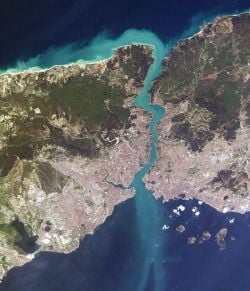
Satellite photo over Istanbul and the
BosporusIstanbul is located in the north-west Marmara Region of Turkey. It encloses the southern Bosporus which places the city on two continents – the western portion of Istanbul is in Europe, while the eastern portion is in Asia. The city boundaries cover a surface area of 1,539 square kilometers, while the metropolitan region, or the Province of Istanbul, covers 6,220 square kilometers.
Climate
The city has a temperate-continental climate, with hot and humid summers; and cold, rainy and often snowy winters. Humidity is generally rather high. Yearly precipitation for Istanbul averages 870 mm. Snowfall is quite common, snowing for a week or two during the winter season, even heavy snows can occur. It is most likely to occur between the months of December and March. The summer months between June and September bring average daytime temperatures of 28 °C (82 °F). The warmest month is July with an average temperature of 23.2 °C (74 °F), the coldest is January with 5.4 °C (42 °F). The weather becomes slightly cooler as one moves toward eastern Istanbul. Summer is by far the driest season. The city is quite windy, having an average wind speed of 17 km/h (11 mph).
Geology
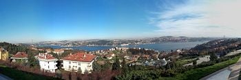
Panoramic view of the
Bosporus from the hills of the Ulus neighborhood
Istanbul is situated near the North Anatolian fault line, which runs from northern Anatolia to the Marmara Sea. Two tectonic plates, the African and the Eurasian, push against each other here. This fault line has been responsible for several deadly earthquakes in the region throughout history. In 1509, a catastrophic earthquake caused a tsunami which broke over the sea-walls of the city, destroying over 100 mosques and killing 10,000 people. An earthquake largely destroyed the Eyüp Sultan Mosque in 1766. The 1894 earthquake caused the collapse of many parts of the Grand Bazaar. A devastating earthquake in August 1999, left 18,000 dead and many more homeless.[5][6] In all of these earthquakes, the devastating effects are a result of the close settlement and poor construction of buildings. Seismologists predict another earthquake, possibly measuring 7.0 on the Richter scale, occurring before 2025.
History
Founding of Byzantium
Greek settlers of Megara colonized the area in 685 B.C.E. Byzantium—then known as Byzantion—takes its name from of King Byzas of Magara under whose leadership the site was reportedly settled in 667. The town became an important trading center due to its strategic location at the Black Sea's only entrance. It later conquered Chalcedon, across the Bosporus.
The city was besieged by Rome and suffered extensive damage in 196 C.E. Byzantium was rebuilt by the Roman Emperor Septimius Severus and quickly regained its previous prosperity, being temporarily renamed as Augusta Antonina by the emperor, in honor of his son.
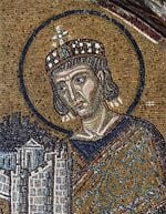
Constantine I, after whom Constantinople was named
The location of Byzantium attracted Constantine the Great in 324 after a prophetic dream was said to have identified the location of the city. The practical reason behind his move was probably Constantine's final victory over Licinius at the Battle of Chrysopolis on the Bosporus, on September 18, 324, which ended the civil war between the Roman co-emperors, and brought an end to the final vestiges of the system in which Nicomedia (present-day İzmit, 100 km east of Istanbul) was the most senior Roman capital city.
Byzantium now called as Nova Roma and eventually Constantinopolis, was officially proclaimed the new capital of the Roman Empire six years later, in 330. Following the death of Theodosius I in 395 and the permanent partition of the Roman Empire between his two sons, Constantinople became the capital of the Eastern Roman (Byzantine) Empire. The unique position of Constantinople at the center of two continents made the city a magnet for international commerce, culture and diplomacy.
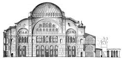
Section of the original design of the Hagia Sophia
The Byzantine Empire was distinctly Greek in culture and became the center of Greek Orthodox Christianity. The capital was adorned with many magnificent churches, including the Hagia Sophia, once the world's largest cathedral. The seat of the Patriarch of Constantinople, spiritual leader of the Eastern Orthodox Church, still remains in the Fener (Phanar) district of Istanbul.
Orthodox and Catholic Christianity permanently split from one another in 1054 amid serious animosity. In 1204, the Fourth Crusade was launched to capture Jerusalem, but instead turned on Constantinople, which was sacked and desecrated. The city subsequently became the center of the Catholic Latin Empire, created by the crusaders to replace the Orthodox Byzantine Empire, which was divided into a number of splinter states. One of these, the Empire of Nicaea was to recapture Constantinople in 1261 under the command of Michael VIII Palaeologus.
Ottoman conquest
Following centuries of decline, Constantinople became surrounded by more youthful and powerful empires, most notably that of the Ottoman Turks. On 29 May 1453, Sultan Mehmed II "the Conqueror" entered Constantinople after a 53–day siege and the city was promptly made the new capital of the Ottoman Empire. The last Byzantine emperor, Constantine XI (Palaeologus), was killed in battle. For three days the city was abandoned to pillage and massacre, after which order was restored by the sultan.
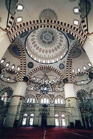
Sinan's Şehzade Mehmet mosque
In the last decades of the Byzantine Empire, the city had decayed as the Byzantine state became increasingly isolated and financially bankrupt; its population had dwindled to some 30,000-40,000 people, while large sections remained uninhabited. Thus, Sultan Mehmed set out to rejuvenate the city economically, creating the Grand Bazaar and inviting the fleeing Orthodox and Catholic inhabitants to return back. Captured prisoners were freed to settle in the city while provincial governors in Rumelia and Anatolia were ordered to send 4,000 families to settle in the city, whether Muslim, Christian or Jew, to form a unique cosmopolitan society.[7] The Sultan also endowed the city with various architectural monuments, including the Topkapı Palace and the Eyüp Sultan Mosque. Religious foundations were established to fund the construction of grand imperial mosques, adjoined by their associated schools, hospitals and public baths.
Suleiman the Magnificent’s reign was a period of great artistic and architectural achievements. The famous architect Sinan designed many mosques and other grand buildings in the city, while Ottoman arts of ceramics and calligraphy also flourished. Many of these survive to this day; some in the form of mosques while others have become museums such as the Cerrahi Tekke and the Sünbül Efendi and Ramazan Efendi Mosques and Türbes; the Galata Mevlevihanesi; the Yahya Efendi Tekke; and the Bektaşi Tekke, which now serves Alevi Muslims as a cemevi (gathering house).
The city was modernized from the 1870s onwards with the construction of bridges, the creation of an updated water system, electric lights, and the introduction of streetcars and telephones.
Panoramic view of the city in the 1870s as seen from Galata Tower (full image)
Modern Istanbul
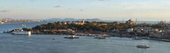
View of the Seraglio Point (Sarayburnu) on the Golden Horn as seen from Galata Tower, with the Sea of Marmara and the Princes' Islands in the background, and Kadıköy (ancient Chalcedon) at left, on the Asian side
When the Republic of Turkey was founded in 1923, the capital was moved from Istanbul to Ankara. In the early years of the republic, Istanbul was overlooked in favor of the new capital. However, in the 1950s, Istanbul underwent great structural change, as new roads and factories were constructed throughout the city. Wide modern boulevards, avenues and public squares were built, sometimes at the expense of the demolition of historical buildings. The city's once numerous and prosperous Greek community, remnants of the city's Greek origins, dwindled in the aftermath of the 1955 Istanbul Pogrom, with most Greeks in Turkey leaving their homes for Greece.
During the 1970s, the population of Istanbul began to rapidly increase as people from Anatolia migrated to the city in order to find employment in the many new factories that were constructed at the outskirts of the city. This sudden sharp increase in the population caused a rapid rise in housing development, some of poor quality, and many previously outlying villages became engulfed into the greater metropolis of Istanbul.
Today, as well as being the country's largest city, Istanbul is the financial, cultural, and economic center of modern Turkey.
Cityscape
Architecture
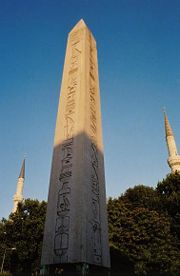
Obelisk of Thutmosis III at the Hippodrome of Constantinople was brought from the Temple of Karnak in
Egypt by
Theodosius the Great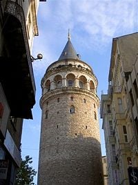
Galata Tower dominates the skyline of the medieval Genoese citadel at the northern side of the Golden Horn
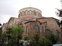
Hagia Irene was one of the most important churches built by Justinian. The mosaics in its interior were removed during the
iconoclastic period and replaced with a simple cross
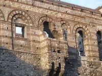
Palace of Porphyrogenitus
Throughout its long history, Istanbul has acquired a reputation for being a cultural and ethnic melting pot. As a result, there are many historical mosques, churches, synagogues, palaces, castles, and towers to visit in the city.
The most important monuments of Roman architecture include the Column of Constantine (Turkish: Çemberlitaş) which was erected in 330 C.E. and reportedly contains several fragments of the Original Cross and the bowl with which Virgin Mary washed the feet of Jesus at its base; the Mazulkemer Aqueduct and Valens Aqueduct; the Column of the Goths (Gotlar Sütunu) at the Seraglio Point; the Milion which served for calculating the distances between Constantinople and other cities of the Roman Empire; and the Hippodrome of Constantinople, which was built following the model of the Circus Maximus in Rome.
The city walls had 55 gates, the largest of which was the Porta Aurea (Golden Gate), the ceremonial entrance gate used by the emperors, at the southwestern end of the triple land walls, close to the Sea of Marmara. Unlike the city walls, which were built of brick and limestone, the Porta Aurea was built of large clean-cut white marble blocks in order to distinguish it from the rest, and a quadriga[8]with elephant statues stood on its top. The doors of the Porta Aurea were made of gold, hence the name, which means Golden Gate in Latin.
Early Byzantine architecture followed the classical Roman model of domes and arches, but further improved these architectural concepts, as evidenced with the Hagia Sophia, which was designed by Isidorus and Anthemius between 532 and 537 during the reign of Justinian the Great.
Many churches with magnificent golden icons were built until the eighth century. Many of these were vandalized during the iconoclasm movement of (730-787) which began with the reign of Leo III the Isaurian. The iconoclasts of this period, like the Muslim counterparts, believed that the images of Christ and other saints on the walls of the churches constituted a sin, and they forcefully had them removed or destroyed. A second iconoclastic period followed in (814-842), initiated by Leo V the Armenian.
During the Fourth Crusade in 1204, most of the city's important buildings were sacked by the forces of Western Christianity, and numerous architectural and artistic treasures were shipped to Venice, whose ruler, Enrico Dandolo, had organized the sack of Constantinople. These items include the famous Statue of the Tetrarchs and the four bronze horse statues that once stood at the top of the Hippodrome of Constantinople, which today stand on the front facade of the Saint Mark's Basilica in Venice.
The Palace of Porphyrogenitus (Turkish: Tekfur Sarayı), which is the only surviving part of the Blachernae Palace, dates from the period of the Fourth Crusade. In these years, on the northern side of the Golden Horn, the Dominican priests of the Catholic Church built the Church of Saint Paul in 1233.
Following the Ottoman conquest of the city, Sultan Mehmed II initiated a wide scale reconstruction plan, which included the construction of grand buildings such as the Eyüp Sultan Mosque, Fatih Mosque, Topkapı Palace, The Grand Bazaar and the Yedikule (Seven Towers) Castle which guarded the main entrance gate of the city, the Porta Aurea (Golden Gate). In the centuries following Mehmed II, many new important buildings, such as the Süleymaniye Mosque, Sultanahmet Mosque, Yeni Mosque and numerous others were constructed.
Traditionally, Ottoman buildings were built of ornate wood. Only "state buildings" such as palaces and mosques were built of stone. Starting from the eighteenth and nineteenth centuries, wood was gradually replaced with stone as the primary building material, while traditional Ottoman architectural styles were replaced with European architectural styles. New palaces and mosques were built in Neoclassical, Baroque and Rococo styles, or a mixture of all three, such as the Dolmabahçe Palace, Dolmabahçe Mosque and Ortaköy Mosque. Even Neo-Gothic mosques were built, such as the Pertevniyal Valide Sultan Mosque and Yıldız Mosque. Large state buildings like schools or military barracks were also built in various European styles.
Urbanism
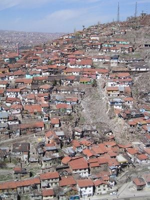
Gecekondu neighborhood in Istanbul
In the last decades, numerous tall structures were built around the city to accommodate a rapid growth in population. Surrounding towns were absorbed into Istanbul as the city rapidly expanded outwards. The tallest high-rise office and residential buildings are mostly located in the northern areas of the European side, which also have numerous upmarket shopping malls.
Starting from the second half of the twentieth century, the Asian side of Istanbul, which was originally a tranquil place full of seaside summer residences and elegant chalet mansions surrounded by lush and vast umbrella pine gardens, experienced massive urban growth.
An improved transportation infrastructure, with both high speed highways and railways, encouraged this growth. Another important factor in the recent growth of the Asian side of the city has been migration from Anatolia. Today, more than one-third of the city's population live in the Asian side of Istanbul.
Due to Istanbul's exponential growth during the second half of the twentieth century, a significant portion of the city's outskirts consist of gecekondus, a Turkish word created in the 1940s meaning "built overnight." These neighborhoods are typically built on abandoned land or on lands owned by others, without the permission of the landowner, and do not obey building codes and regulations. At present, gecekondu areas are being gradually demolished and replaced by modern mass-housing complexes.
Administration
Organization
The metropolitan model of governance has been used with the establishment of metropolitan administration in 1930. The metropolitan council is accepted as the competent authority for decision-making. The metropolitan government structure consists of three main organs: (1) The Metropolitan Mayor (elected every five years), (2) The Metropolitan Council (decision making body with the mayor, district Mayors, and one fifth of the district municipal councilors), (3) The metropolitan executive committee. There are three types of local authorities: municipalities, special provincial administrations, and village administrations. Among the local authorities, municipalities are gaining greater importance with the rise in urbanization.
Istanbul has 31 districts. These can be divided into three main areas: the historic peninsula, the areas north of the Golden Horn, and the Asian side.
Demographics
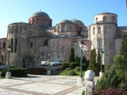
Zeyrek Mosque, formerly the Church of Christ Pantokrator, is the second largest surviving Byzantine religious structure in the city
The population of the metropolis has more than tripled during the 25 years between 1980 and 2005. Roughly 70 percent of all Istanbulers live in the European section and around 30 percent live in the Asian section. The doubling of the population of Istanbul between 1980 and 1985 is due to a natural increase in population as well as the expansion of municipal limits.
Religion
The urban landscape of Istanbul is shaped by its many religious communities. The most populous religion is Islam. Istanbul was the final seat of the Islamic Caliphate, between 1517 and 1924. The supposed personal belongings of the prophet Muhammad and the earliest Caliphs who followed him are today preserved in the Topkapı Palace, the Eyüp Sultan Mosque and in several other prominent mosques of Istanbul. Religious minorities include Greek Orthodox Christians, Armenian Christians, Catholic Levantines and Sephardic Jews. Some districts have sizable populations of these ethnic groups.
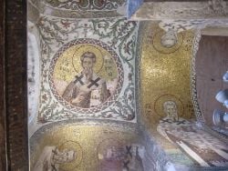
Pammakaristos Church has a large number of Byzantine mosaics.
Following the Turkish conquest of Constantinople in 1453, the various ethnic groups were to be governed by a group of institutions based on faith. Many of the internal affairs of these communities were assigned to the administration of their religious authorities, such as the Ecumenical Patriarchate for the affairs of Orthodox Christians, the Armenian Patriarchate for the affairs of the Armenian Christians, and later the Grand Rabbi for the affairs of the Jews.
The population of the Armenian and Greek minorities in Istanbul greatly declined beginning in the late nineteenth century. The city's Greek Orthodox community were exempted from the population exchange between Greece and Turkey of 1923. However, a series of special restrictions and taxes beginning in the 1930s, finally culminating in the Istanbul Pogrom of 1955, greatly increased emigration; and in 1964, all Greeks without Turkish citizenship residing in Turkey (around 100,000) were deported. Today, most of Turkey's remaining Greek and Armenian minorities live in or near Istanbul.
The Sephardic Jews have lived in the city for over 500 years, see the history of the Jews in Turkey. Together with the Arabs, the Jews fled the Iberian Peninsula during the Spanish Inquisition of 1492, when they were forced to convert to Christianity after the fall of the Moorish Kingdom of Andalucia. The Ottoman Sultan Bayezid II (1481-1512) sent a sizable fleet to Spain under the command of Kemal Reis to rescue Arabs and Jews who faced torture and death because of their faith. More than 200,000 Spanish Jews fled first to locations such as Tangier, Algiers, Genova and Marseille, later to Salonica, and finally to Istanbul. The Sultan granted Ottoman citizenship to over 93,000 of these Spanish Jews. Another large group of Sephardic Jews came from southern Italy, which was under Spanish control. The first Gutenberg press in Istanbul was established by the Sephardic Jews in 1493, who excelled in many areas, particularly medicine, trade and banking. More than 20,000 Jews still remain in Istanbul today.
There is also a relatively smaller and more recent community of Ashkenazi (northern European) Jews in Istanbul who continue to live in the city since the nineteenth century. A second large wave of Ashkenazi Jews came to Istanbul during the 1930s and 1940s following the rise of Nazism in Germany which persecuted the Ashkenazi Jews of central and eastern Europe.
During the Byzantine period, the Genoese Podestà ruled over the Italian community of Galata, which was mostly made up of the Genoese, Venetians, Tuscans and Ragusans. Following the Turkish siege of Constantinople in 1453, during which the Genoese sided with the Byzantines and defended the city together with them, the Ottoman Sultan Mehmed II allowed the Genoese (who had fled to their colonies in the Aegean Sea such as Lesbos and Chios) to return back to the city.
There were more than 40,000 Catholic Italians in Istanbul at the turn of the twentieth century, a figure which not only included the descendants of the local Genoese and Venetian merchants who lived there since the Byzantine and early Ottoman periods, but also the numerous Italian workers and artisans who came to the city from southern Italy during the nineteenth century.
The number of Istanbul's Italians decreased after the end of the Ottoman Empire for several reasons. The Turkish Republic no longer recognized the trade privileges that were given to the descendants of the Genoese and Venetian merchants, and foreigners were no longer allowed to work in Turkey in a wide number of sectors, including many artisanships, in which numerous Istanbulite Italians used to work. The Varlık Vergisi (Wealth Tax) of the World War II years, which imposed higher tariffs on non-Muslims and foreigners in Turkey, also played an important role in the migration of Istanbul's Italians to Italy - some, who still live in the city, but in far fewer numbers when compared with the early twentieth century. The influence of the Italian community of Istanbul, however, is still visible in the architecture of many quarters, particularly Galata, Beyoğlu and Nişantaşı.
Economy
Historically, Istanbul has been the center of the country's economic life due to its location as an international junction of land and sea trade routes. In 2005 the City of Istanbul had a GDP of $133 billion, outranking many prominent cities in the world.
Akmerkez in the quarter of Etiler is the only shopping mall in the world which won both "Europe's Best" and "World's Best" awards by ICSC
In the late 1990s, the economy of Turkey, and Istanbul in particular, suffered several major depressions. The Asian financial crisis between July 1997 and the beginning of 1998, as well as the crisis in Russia between August 1998 and the middle of 1999 had negative effects in all areas of the economy, particularly on exports. Following this setback, a slow reorganization of the economy of Istanbul was observed in 1999.
The major earthquake with its epicenter in nearby Kocaeli on August 17, 1999, triggered one of the largest economic shocks for the city. Apart from the capital and human losses caused by the disaster, a decrease in GDP of approximately two percent occurred. Despite these downturns, Istanbul's economy has strongly improved and recovered in the recent years.
Industry
Istanbul is the "industrial center" of Turkey. It employs approximately 20 percent of Turkey's industrial labor and contributes 38 percent of Turkey's industrial workspace. In addition, the city generates 55 percent of Turkey's trade and 45 percent of the country's wholesale trade, and generates 21.2 percent of Turkey's gross national product. Istanbul contributes 40 percent of all taxes collected in Turkey and produces 27.5 percent of Turkey's national product.
Many of Turkey's major manufacturing plants are located in the city. Istanbul and its surrounding province produce cotton, fruit, olive oil, silk, and tobacco. Food processing, textile production, oil products, rubber, metal ware, leather, chemicals, electronics, glass, machinery, paper and paper products, and alcoholic drinks are among the city's major industrial products. The city also has plants that assemble automobiles and trucks.
Pharmaceutical industry started in 1952 with the establishment of "Eczacıbaşı Pharmaceuticals Factory" in Levent, Istanbul.[9] Today, 134 companies operate in the Turkish pharmaceutical industry, a significant part of which is based within or near Istanbul.[10]
Tourism
Istanbul is one of the most important tourism spots of Turkey. There are thousands of hotels and other tourist oriented industries in the city, catering to both vacationers and visiting professionals. In 2006 a total of 23 million tourists visited Turkey, most of whom entered the country through the airports and seaports of Istanbul and Antalya.[11]
Istanbul is also one of the world’s most exciting conference destinations and is an increasingly popular choice for the world’s leading international associations.
Infrastructure
Health and medicine
The city has many public and private hospitals, clinics and laboratories within its boundaries and numerous medical research centers. Many of these facilities have high technology equipment, which has contributed to the recent upsurge in "medical tourism" to Istanbul, [12]particularly from West European countries like the United Kingdom and Germany where governments send patients with lower incomes to the city for the relatively inexpensive service of high-tech medical treatment and operations. Istanbul has particularly become a global destination for laser eye surgery and plastic surgery. The city also has an Army Veterans Hospital in the military medical center.
Pollution-related health problems increase especially in the winter, when use of heating fuels increase. The rising number of new cars in the city and the slow development of public transportation often cause urban smog conditions. Mandatory use of unleaded gas was scheduled to begin only in January 2006.
Utilities
The first water supply systems which were built in Istanbul date back to the foundation of the city. Two of the greatest aqueducts built in the Roman period are the Mazulkemer Aqueduct and the Valens Aqueduct. These aqueducts were built in order to channel water from the Halkalı area in the western edge of the city to the Beyazıt district in the city center, which was known as the Forum Tauri in the Roman period. After reaching the city center, the water was later collected in the city's numerous cisterns, such as the famous Philoxenos (Binbirdirek) Cistern and the Basilica (Yerebatan) Cistern. Sultan Suleiman the Magnificent commissioned Sinan, his engineer and architect-in-chief, to improve the water needs of the city. Sinan constructed the Kırkçeşme Water Supply System in 1555. In later years, with the aim of responding to the ever-increasing public demand, water from various springs was channeled to the public fountains by means of small supply lines.
Today, Istanbul has a chlorinated and filtered water supply and a sewage disposal system managed by the government agency ISKI. The current level of facilities, however, is not sufficient enough to meet the rising demand of the growing city. Water supply sometimes becomes a problem, particularly in the summer.
Electricity distribution services are covered by the state-owned TEK. The first electricity production plant in the city, Silahtarağa Termik Santrali, was established in 1914 and continued to supply electricity until 1983.
The Ottoman Ministry of Post and Telegraph was established in the city on October 23, 1840. The first post office was the Postahane-i Amire near the courtyard of Yeni Mosque. In 1876 the first international postal network between Istanbul and the lands beyond the vast Ottoman Empire was established.[13]
Samuel Morse received his first ever patent for the telegraph in 1847, at the old Beylerbeyi Palace (the present Beylerbeyi Palace was built in 1861-1865 on the same location) in Istanbul, which was issued by Sultan Abdülmecid who personally tested the new invention.[14] Following this successful test, installation works of the first telegraph line between Istanbul and Edirne began on August 9, 1847. In 1855 the Telegraph Administration was established. In July 1881 the first telephone circuit in Istanbul was established between the Ministry of Post and Telegraph in Soğukçeşme and the Postahane-i Amire in Yenicami. On October 23, 1986, mobile telephone and paging systems were put into service in Istanbul, Ankara and İzmir. On February 23, 1994, GSM technology was established in the city. A nationwide Internet network and connection with the World Wide Web was established in 1996.
Infrastructure improvements since the mid 1990s include the resolution of the garbage problem, improved traffic conditions and improved air quality due to the increased use of natural gas.
Transportation
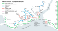
İstanbul rail transit map
Istanbul has two international airports: The larger one is the Atatürk International Airport located in the Yeşilköy district on the European side, about 24 kilometers west from the city center. When it was first built, the airport used to be at the western edge of the metropolitan area but now lies within the city bounds.
The smaller one is the Sabiha Gökçen International Airport located in the Kurtköy district on the Asian side, close to the Istanbul Park GP Racing Circuit. It is situated approximately 20 kilometers east of the Asian side and 45 kilometers east of the European city center.
The Sirkeci Terminal of the Turkish State Railways (TCDD) is the terminus of all the lines on the European side and the main connection node of the Turkish railway network with the rest of Europe. Currently, international connections are provided by the line running between Istanbul and Thessaloniki, Greece, and the Bosporus Express serving daily between Sirkeci and Gara de Nord in Bucharest, Romania. Lines to Sofia, Belgrade, Budapest, and Chişinău are established over the Bosporus Express connection to Bucharest. Sirkeci Terminal was originally opened as the terminus of the Orient Express.
Sea transport is vital for Istanbul, as the city is practically surrounded by sea on all sides: the Sea of Marmara, the Golden Horn, the Bosporus and the Black Sea. Many Istanbulers live on the Asian side of the city but work on the European side (or vice-versa) and the city's famous commuter ferries form the backbone of the daily transition between the two parts of the city - even more so than the two suspension bridges which span the Bosporus.
The port of Istanbul is the most important one in the country. The old port on the Golden Horn serves primarily for personal navigation, while Karaköy port in Galata is used by the large cruise liners. Istanbul Modern, the city's largest museum and gallery of modern arts, is located close to Karaköy port.
Life in the city
Istanbul Archaeology Museum
Art & culture
Istanbul is becoming increasingly colorful in terms of its rich social, cultural, and commercial activities. While world famous pop stars fill stadiums, activities like opera, ballet and theater continue throughout the year. During seasonal festivals, world famous orchestras, chorale ensembles, concerts and jazz legends can be found often playing to a full house.
Istanbul Archeology Museum, established in 1881, is one of the largest and most famous museums of its kind in the world. The museum contains more than 1,000,000 archaeological pieces from the Mediterranean basin, the Balkans, the Middle East, North Africa and Central Asia.
A significant culture has been developed around what is known as a Turkish Bath (Hamam), the origins of which can be traced back to the ancient Roman Bath, which was a part of the Byzantine lifestyle and customs that were inherited first by the Seljuk Turks and later the Ottomans, who developed it into something more elaborate.
Media
The first Turkish newspaper, Takvim-i Vekayi, was printed on 1 August 1831 in the Bâbıâli (Bâb-ı Âli, meaning The Sublime Porte) district. Bâbıâli became the main center for print media. Istanbul is also the printing capital of Turkey with a wide variety of domestic and foreign periodicals expressing diverse views, and domestic newspapers are extremely competitive. Most nationwide newspapers are based in Istanbul, with simultaneous Ankara and İzmir editions. There are also numerous local and national TV and radio stations located in Istanbul.
Education
Istanbul holds some of the finest institutions of higher education in Turkey, including a number of public and private universities. Most of the reputable universities are public, but in recent years there has also been an upsurge in the number of private universities. Istanbul University (1453) is the oldest Turkish educational institution in the city, while Istanbul Technical University (1773) is the world's second-oldest technical university dedicated entirely to engineering sciences. Other prominent state universities in Istanbul are the Boğaziçi University (1863), Mimar Sinan University of Fine Arts (1882), Marmara University (1883), Yıldız Technical University (1911) and Galatasaray University (1992).
Almost all Turkish private high schools and universities in Istanbul teach in English, German or French as the primary foreign language, usually accompanied by a secondary foreign language.
Sports
The first modern sports club established during the late Ottoman period was Beşiktaş Jimnastik Kulübü (1903). Beşiktaş JK was followed by Galatasaray SK (1905) and Fenerbahçe SK (1907). Galatasaray became the first Turkish football club to win European titles (the UEFA Cup and UEFA Super Cup of 2000). At present, Galatasaray is also the Turkish team with the most Turkish Super League titles (16) along with Fenerbahçe (16); followed by Beşiktaş (12) and Trabzonspor (6).
The Atatürk Olympic Stadium is a five-star UEFA stadium and a first-class venue for track and field, having reached the highest required standards set by the International Olympic Committee and sports federations such as the IAAF, FIFA and UEFA. The stadium hosted the 2005 UEFA Champions League Final.
Istanbul hosts several annual motorsports events, such as the Formula One Turkish Grand Prix, the MotoGP Grand Prix of Turkey, the FIA World Touring Car Championship, the GP2 and the Le Mans Series 1000 km races at the Istanbul Park GP Racing Circuit.
Notes
- ↑ The Results of Address Based Population Registration System, 2017 Turkish Statistical Institute, February 1, 2018. Retrieved March 26, 2018.
- ↑ Richard Krautheimer, Three Christian Capitals: Topography and Politics (Berkeley: University of California Press, 1987).
- ↑ Stanford J. Shaw and K. Ezel, History of the Ottoman Empire and Modern Turkey (Cambridge: Cambridge University Press, vol. II. 1977), 386.
- ↑ Richard D. Robinson, The First Turkish Republic (Cambridge, MA: Harvard University Press, 1965), 298.
- ↑ "Istanbul advised to brace for major quake." Environmental News Network via CNN, April 28, 2000. Retrieved March 26, 2018.
- ↑ T. Parsons, et al., "Heightened odds of large earthquakes near Istanbul: An interaction-based probability calculation." Science, 288(5466) (April 28, 2000): 61-65. Retrieved March 26, 2018.
- ↑ John Balfour Kinross, The Ottoman Centuries: The Rise and Fall of the Turkish Empire (New York: Vintage/Ebury (A Division of Random House Group), [1977] 1997), 117
- ↑ A two-wheeled chariot drawn by four horses harnessed abreast.
- ↑ Baytop T. Türk Eczacılık Tarihi Araştırmaları (History of Turkish Pharmacy Researches) Istanbul. 2000:12-75.
- ↑ Dogan UVEY*, Ayse Nur GOKCE*, Ibrahim BASAGAOGLU (2004) "Pharmaceutical Industry in Turkey" in 38th International Medical History Congress in Istanbul.
- ↑ Hürriyet Haber, Hürriyet: 2006’da Türkiye’ye gelen turist başına harcama 728 dolara indi. www.hurriyet.com.tr, January 31, 2007. Retrieved March 26, 2018.
- ↑ Med Retreat - Medical Tourism: Turkey. www.medretreat.com. Retrieved March 26, 2018.
- ↑ ISTANBUL, Extended On Two Continents. İstanbul PTT Museum,
July 22, 2017. Retrieved March 26, 2018.
- ↑ Mansions and Palaces: Beylerbeyi Palace. Istanbul City Guide. Retrieved March 26, 2018.
References
ISBN links support NWE through referral fees
- Freely, John. Istanbul: The Imperial City. Penguin Books, 1996. ISBN 978-0140244618
- Kinross, John Balfour. The Ottoman Centuries: The Rise and Fall of the Turkish Empire. Vintage/Ebury (A Division of Random House Group), 1977. ISBN 978-0224013796
- Krautheimer, Richard. Three Christian Capitals: Topography and Politics. University of California Press, 1987. ISBN 978-0520060340
- Robinson, Richard D. The First Turkish Republic. Harvard University Press, 1963. ISBN 978-0674304505
- Shaw, Stanford J. and K. Ezel. History of the Ottoman Empire and Modern Turkey. Cambridge: Cambridge University Press, vol. II, 1977. ISBN 978-0521291668
Credits
New World Encyclopedia writers and editors rewrote and completed the Wikipedia article
in accordance with New World Encyclopedia standards. This article abides by terms of the Creative Commons CC-by-sa 3.0 License (CC-by-sa), which may be used and disseminated with proper attribution. Credit is due under the terms of this license that can reference both the New World Encyclopedia contributors and the selfless volunteer contributors of the Wikimedia Foundation. To cite this article click here for a list of acceptable citing formats.The history of earlier contributions by wikipedians is accessible to researchers here:
The history of this article since it was imported to New World Encyclopedia:
Note: Some restrictions may apply to use of individual images which are separately licensed.


.jpg)


.jpg)


_-_San_Gregorio_armeno_-_Foto_G._Dall%27Orto_26-5-2006.jpg)


