Grand Teton National Park
| Grand Teton National Park | |
|---|---|
| IUCN Category II (National Park) | |
 | |
| Location: | Wyoming, USA |
| Nearest city: | Jackson, WY |
| Area: | 309,995 acres (1,255 km²) |
| Established: | February 26 1929 |
| Visitation: | 2,406,476 (in 2006) |
| Governing body: | National Park Service |
- ARTICLE CLAIMED FOR PATTY STEFFEN
Grand Teton National Park is a United States National Park located in western Wyoming, south of Yellowstone National Park. It is named after Grand Teton, which at 13,770 feet (4197 m), is the tallest mountain in the Teton Range.
The mountains were named by a French trapper who viewed them from the Idaho side of the range and called them tétons, French slang for "nipples" (presumably referring to the shape of the peaks). It was established as a national park on February 26 1929. The park covers 484 mi² (1,255 km²) of land and water.
There are nearly 200 miles (320 km) of trails for hikers to enjoy in Grand Teton National Park.
Geography

Part of the Rocky Mountains, the north-south-trending Teton Range rises from the floor of Jackson Hole without any foothills along a 40 mile (65 km) long by 7 to 9 miles (11 to 15 km) wide active fault-block mountain front system. In addition to 13,770 foot (4197 m) high Grand Teton, another twelve peaks are over 12,000 ft (3660 m) above sea level. Seven of these peaks between Avalanche and Cascade canyons make up the often-photographed Cathedral Group.

Jackson Hole is a 55 mile (90 km) long by 6 to 13 mile (10 to 20 km) wide graben valley that has an average elevation of 6,800 feet (2070 m) with its lowest point near the south park boundary at 6350 feet (1935 m). The valley sits east of the Teton Range and is vertically displaced downward 30,000 feet (9100 m) from corresponding rock layers in it, making the Teton Fault and its parallel twin on the east side of the valley normal faults with the Jackson Hole block being the hanging wall and the Teton Mountain block being the footwall. Grand Teton National Park contains the major part of both blocks. A great deal of erosion of the range and sediment filling the graben, however, yields a topographic relief of only up to 7700 feet (2350 m).
The glaciated range is composed of a series of horns and arêtes separated by U-shaped valleys headed by cirques and ended by moraines, making the Tetons a textbook example of alpine topography. Rubble piles left by ice age alpine glaciers impounded a series of interconnected lakes at the foot of the range (Jackson, Leigh, String, Jenny, Bradley, Taggart, and Phelps). The largest lake in the valley, Jackson Lake, was impounded by a recessional moraine left by a very large valley glacier as it retreated north out of Jackson Hole. Jackson Lake covers 25,540 acres (103.4 km²) and has a maximum depth of 438 feet (134 m). There are also over 100 alpine and backcountry lakes.
Just to the south is Burned Ridge, the same glacier's terminal or end moraine, which runs down the center of Jackson Hole roughly perpendicular to the range and cut in two by the Snake River. After exiting its dammed outlet at the southeast corner of Jackson Lake, the Snake runs down the valley and through the 10 mile (16 km) long glacial outwash plain south of Burned Ridge. The river's headwaters are in a part of the Teton Wilderness a short distance north in Yellowstone National Park and its destination is the Columbia River far to the west, which in turn empties into the Pacific Ocean. Terraces have been cut by the river into the moraines and outwash plain in the valley. About 50 miles (80 km) of the 1056 miles (1699 km) mile long Snake River winds through the park where it is fed by three major tributaries; Pacific Creek, Buffalo Fork, and the Gros Ventre River.
The local climate is a semi-arid mountain one with a yearly extreme high of 93 °F (34 ° C) and extreme low of −46 °F (−43 ° C). Average annual snowfall is 191 inches (490 cm) and average rainfall is 10 inches (250 mm). The coldest temperature ever recorded in Grand Teton National Park was −63 °F (−52 °C), and snow often blankets the landscape from early November to late April.


Human history
Pre-history
Native American hunting parties from the northern Rocky Mountains camped along the shore of Jackson Lake around 12,000 years ago while following game. For thousands of years Jackson Hole was used as a neutral crossroads for trade and travel routes in the area. One route followed the Snake River to its source in the Yellowstone area where abundant obsidian could be found. Another major route traversed the Teton Pass at the southern end of the range, providing a shortcut to the Pacific Northwest region of what is now the United States. Also, a southern route led to the Colorado Plateaus region and the Great Basin.
White exploration and settlement
The Tetons were named by French explorers who called the three highest peaks of the range Les Trois Tetons (the three breasts). In the 18th and 19th centuries, Caucasian fur trappers and fur traders called deep valleys rimmed by high mountains "holes." One such fur trapper was named David Jackson and his favorite place to 'hole-up' was named after him in 1829.
John Colter, a member of the Lewis and Clark Expedition, is the first white American known to have visited the area now know as Jackson Hole as early as 1805-1806. Geologist F.V. Hayden visited the area in 1860 as part of the Raynolds expedition. In the summer of 1871 he led the first government-sponsored scientific survey of the Yellowstone area just to the north. One part of that survey, led by geologist James Stevenson, they traveled into Jackson Hole via the Teton Pass before meeting up with the other half of the expedition in Yellowstone. While passing through, the team, which included Yellowstone's first superintendent N.P. Longford, photographer William Henry Jackson, and artist William Henry Holmes, among others, mapped the area and surveyed its geology and biology.These data were later included in the Hayden Survey set of reports.
Homesteaders moved into Jackson Hole after the reports were published but the short growing season along with weeks of being snowed-in each winter kept all but the hardiest individuals away. One of those settlers, a rancher named Pierce Cunningham, circulated a petition to have Jackson Hole saved for the "education and enjoyment of the Nation as a whole."
Fight for preservation

In 1897 acting Yellowstone superintendent Colonel S.B.M. Young proposed expanding that park's borders south to encompass the northern extent of Jackson Hole in order to protect migrating herds of elk. Next year, United States Geological Survey head Charles D. Walcott suggested that the Teton Range should be included as well. Stephen Mather, director of the newly-created National Park Service and his assistant Horace Albright sent a report to Secretary of the Interior Franklin Lane in 1917 stating much the same. Wyoming Representative Frank Mondell sponsored a bill that unanimously passed the United States House of Representatives in 1918 but was killed in the United States Senate when Idaho Senator John Nugent feared that the expansion of Park Service jurisdiction would threaten sheep grazing permits. Public opposition to park expansion also mounted in and around Jackson Hole. Albright, in fact, was practically run out of Jackson, Wyoming, by angry townspeople in 1919 when he traveled there to speak in favor of park expansion.
Local attitudes started to change that same year when proposals to dam Jenny, Emma Matilda, and Two Ocean lakes surfaced. Then on July 26 1923, local and Park Service representatives including Albright met in Maud Noble's cabin to work on a plan to buy private lands to create a recreation area to preserve the "Old West" character of the valley. Albright was the only person who supported Park Service management; the others wanted traditional hunting, grazing, and dude-ranching activities to continue. In 1927 philanthropist John D. Rockefeller, Jr. founded the Snake River Land Company so he and others could buy land in the area incognito and have it held until the National Park Service could administer it. The company launched a campaign to purchase more than 35,000 acres (142 km²) for $1.4 million but faced 15 years of opposition by ranchers and a refusal by the Park Service to take the land.

In 1928, a Coordinating Commission on National Parks and Forests met with valley residents and reached an agreement for the establishment of a park. Wyoming Senator John Kendrick then introduced a bill to establish Grand Teton National Park. It was passed by both houses of the U.S. Congress and signed into law by U.S. President Calvin Coolidge on February 26 1929. The 96,000 acre (388 km²) park was carved from Teton National Forest and included the Teton Range and six glacial lakes at its foot in Jackson Hole. Lobbying by cattlemen, however, meant that the original park borders did not include most of Jackson Hole (whose floor was used for grazing). Meanwhile the Park Service refused to accept the 35,000 acres (142 km²) held by the Snake River Company.
Discouraged by the stalemate, Rockefeller sent a letter to then U.S. President Franklin D. Roosevelt telling him that if the federal government did not accept the land that he intended to make some other disposition of it or to sell it in the market to any satisfactory buyers. Soon afterward on March 15 1943 the president declared 221,000 acres (894 km²) of public land as Jackson Hole National Monument. Continued controversy over the Rockefeller gift still made it impossible for the monument to officially include that land, however.
Opposition to the monument by local residents immediately followed with criticism that the declaration was a violation of states' rights and that it would destroy the local economy and tax base. Ranchers drove 500 cattle across the newly created monument in a demonstration designed to provoke conflict. The Park Service did not respond to the stunt but the event brought national attention to the issue nonetheless. Wyoming Representative Frank Barrett introduced a bill to abolish the monument that passed both houses of Congress but was pocket vetoed by Roosevelt. U.S. Forest Service officials did not want to cede another large part of the Teton National Forest to the Park Service so they fought against transfer. One final act was to order forest rangers to gut the Jackson Lake Ranger Station before handing it over to park rangers. Residents in the area who supported the park and the monument were boycotted and harassed.
Other bills to abolish the monument were introduced between 1945 and 1947 but none passed. Increases in tourism money following the end of World War II has been cited as a cause of the change in local attitudes. A move to merge the monument into an enlarged park gained steam and by April, 1949, interested parties gathered the Senate Appropriation Committee chambers to finalize a compromise. The Rockefeller lands were finally transferred from private to public ownership on December 16 1949, when they were added to the monument. A bill merging most of Jackson Hole National Monument (except for its southern extent, which was added to the National Elk Refuge) into Grand Teton National Park was signed into law by President Harry S. Truman on September 14 1950. One concession in the law modified the Antiquities Act, limiting the future power of a president to proclaim National Monuments in Wyoming. The scenic highway that extends from the northern border of Grand Teton National Park to the southern entrance of Yellowstone National Park was named the John D. Rockefeller, Jr. Memorial Parkway to recognize Rockefeller's contribution to protecting the area.
A meteor on a path over the Rocky Mountains from the U.S. Southwest to Canada passed above the park area on August 10, 1972, and was filmed by a tourist with an 8-millimeter color film camera. The object was in the range of size from a car to a house and should have ended its life in a Hiroshima-sized blast, but there was never any explosion, much less a crater. Analysis of the trajectory indicated that it never came much lower than 58 kilometers off the ground, and the conclusion was that it had grazed Earth's atmosphere for about 100 seconds, then skipped back out of the atmosphere to return to its orbit around the Sun.
Geology

The rock units that make up the east face of the Teton Range are around 2500 million years old and made of metamorphosed sandstones, limestones, various shales, and interbeded volcanic deposits. Buried deep under Tertiary volcanic, sedimentary, and glacial deposits in Jackson Hole, these same Precambrian rocks are overlain by Paleozoic and Mesozoic formations that have long since been eroded away from atop the Tetons.
The Paleozoic-aged sediments were deposited in warm shallow seas and resulted in various carbonate rocks along with sandstones and shales. Mesozoic deposition transitioned back and forth from marine to non-marine sediments. In later Mesozoic, the Cretaceous Seaway periodically covered the region and the Sierran Arc to the west provided volcanic sediments.
A mountain-building episode called the Laramide orogeny started to uplift western North America 70 million years ago and eventually formed the Rocky Mountains. This erased the seaway and created fault systems along which highlands rose. Sediment eroded from uplifted areas filled-in subsiding basins such as Jackson Hole while reverse faults created the first part of the Teton Range in the Eocene epoch. Large Eocene-aged volcanic eruptions from the north in the Yellowstone-Absaroka area along with later Pleistocene-aged Yellowstone Caldera eruptions, left thick volcanic deposits in basins (see geology of the Yellowstone area).
The Teton Range started to grow along a north-south trending fault system next to Jackson Hole some 9 million years ago in the Miocene epoch. Then starting in the Pliocene, Lake Teewinot periodically filled Jackson Hole and left thick lakebed sediments. The lake was dry by the time a series of glaciations in the Pleistocene epoch saw the introduction of large glaciers in the Teton and surrounding ranges. During the coldest ice age these glaciers melded together to become part of the Canadian Ice Sheet, which carried away all soil from Jackson Hole and surrounding basins. Later and less severe ice ages created enough locally-deposited dirt in the form of moraines and till to repair much of this damage. Since then, mass wasting events such as the 1925 Gros Ventre landslide, along with slower forms of erosion, have continued to modify the area.
Biology

Over 1000 species of vascular plants grow in Grand Teton National Park and the surrounding area. Some trees, such as the Whitebark Pine, Limber Pine, Subalpine fir, and Engelmann Spruce can survive the cold windy slopes and alpine zone high up in the Tetons to around 10,000 feet (~3000 m). Other evergreens, like the Lodgepole Pine, Douglas Fir, and Blue Spruce, are more commonly found on the valley floor, while the aspens, cottonwoods, alders, and willows prefer the moist soils found along the rivers and lakeshores.

Grand Teton forests generally contain two or three different types of trees growing together in a specific habitat type. These forests merge into one another in zones called ecotones, which creates edge habitat for various species of wildlife. Some animals, like the red squirrel, pine marten, and black bear spend most of their time in the forests. Others, such as moose, elk (also known as the wapiti), and wolves, seek the forest for shade and shelter during the day and move out to the sagebrush or meadows to feed in the early mornings and evenings.
Soil conditions, availability of moisture, slope, aspect, and elevation all determine where plants grow. Plants that require similar conditions are often found growing in the same area. These associations form various plant communities. It is useful to divide the plants of Grand Teton National Park into the following communities: forests, sagebrush flats, riparian corridors and wetlands, and alpine areas.
Evergreen forests composed of 7 coniferous tree species and over 900 species of flowering plants dominate the mountainous part of the Teton Range below the treeline and extend into Jackson Hole on top of moraines. These compact piles of unsorted rubble have good clay content and retain moisture better than the quartzite-rich outwash plain and are thus able to support large stands of Lodgepole Pines along with many other plants.

The loose soil of the outwash plain has a poor ability to hold moisture, resulting in a sparse vegetation cover primarily made of sagebrush and coarse grasses. Abundant aspens, cottonwoods, and willows thrive along streams in riparian zones outside of the barren outwash plain. Wet meadows provide the conditions suited to grasses, sedges, and wildflowers. Coyotes and badgers dig burrows in patches of loesses, which were blown into the valley between ice ages. Although they appear gray and lifeless, the high alpine reaches of the park support plants specially adapted to the harsh growing conditions found there. Wind, snow, lack of soil, increased ultraviolet radiation, rapid and dramatic shifts in temperature, and a short growing season all challenge the hardy plants that survive here. Most plants adapt by growing close to the ground in mats like the Alpine Forget-me-not.
Selected wildlife

Grand Teton National Park is located in the heart of the Greater Yellowstone Ecosystem, one of the largest intact temperate zone ecosystems remaining on the planet. This means that many of the animals in the Teton area travel between the two parks and the numerous adjacent National Forests.
- 5 species of Amphibians: Spotted Frog, Boreal Chorus Frog, Boreal Toad, Tiger Salamander, Northern Leopard Frog (believed to be locally extinct), and Bullfrog (introduced just outside the park).
- 6 species of bats
- 300+ species of birds: including Bald Eagle, Calliope Hummingbird, Golden Eagle, Osprey, Sage Grouse, Trumpeter Swan, Western Tanager
- 17 species of carnivores: including Grizzly and Black Bear, Mountain Lion, Wolf and Coyote.
- 16 species of fishes: including Yellowstone cutthroat trout, Snake River cutthroat trout, Mountain Sucker, Utah Chub, and Mountain Whitefish
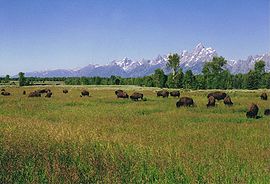 American Bison graze the bottomlands.
 - 6 species of hoofed mammals: including American Bison, Moose, Pronghorn, Elk, and Mule Deer
- numerous invertebrates (no poisonous spiders)
- 3 species of rabbits/hares
- 4 species of reptiles (none poisonous): Wandering Garter Snake, Valley Garter Snake, Rubber Boa, and Northern Sagebrush Lizard
- 22 species of rodents: including Yellow-Bellied Marmot, Least Chipmunk, Muskrat, Red Squirrel, and Uinta Ground Squirrel

Sources and Further reading
- Harris, Ann G., Esther Tuttle, and Sherwood D. Tuttle. 1990. Geology of national parks: Fifth Edition. Dubuque, Iowa: Kendall/Hunt Pub. Co. ISBN 0840346190 and ISBN 9780840346193
- National Park Service. Grand Teton Facts. Retrieved August 17, 2007.
- National Park Service. Creation of Grand Teton National Park. Retrieved August 17, 2007.
- National Park Service. Grand Teton Nature and Science. Retrieved August 17, 2007.
- Daugherty, John, Stephanie Crockett, William H. Goetzmann, and Reynold G. Jackson. 1999. A place called Jackson Hole: the historic resource study of Grand Teton National Park. Moose, Wyoming: Grand Teton National Park, National Park Service.
External links
- National Park Service. Grand Teton National Park. Retrieved August 17, 2007.
| National parks of the United States | |
|---|---|
| Acadia • American Samoa • Arches • Badlands • Big Bend • Biscayne • Black Canyon of the Gunnison • Bryce Canyon • Canyonlands • Capitol Reef • Carlsbad Caverns • Channel Islands • Congaree • Crater Lake • Cuyahoga Valley • Death Valley • Denali • Dry Tortugas • Everglades • Gates of the Arctic • Glacier • Glacier Bay • Grand Canyon • Grand Teton • Great Basin • Great Sand Dunes • Great Smoky Mountains • Guadalupe Mountains • Haleakala • Hawaii Volcanoes • Hot Springs • Isle Royale • Joshua Tree • Katmai • Kenai Fjords • Kings Canyon • Kobuk Valley • Lake Clark • Lassen Volcanic • Mammoth Cave • Mesa Verde • Mount Rainier • North Cascades • Olympic • Petrified Forest • Redwood • Rocky Mountain • Saguaro • Sequoia • Shenandoah • Theodore Roosevelt • Virgin Islands • Voyageurs • Wind Cave • Wrangell-St. Elias • Yellowstone • Yosemite • Zion List by: date established, state |
Credits
New World Encyclopedia writers and editors rewrote and completed the Wikipedia article in accordance with New World Encyclopedia standards. This article abides by terms of the Creative Commons CC-by-sa 3.0 License (CC-by-sa), which may be used and disseminated with proper attribution. Credit is due under the terms of this license that can reference both the New World Encyclopedia contributors and the selfless volunteer contributors of the Wikimedia Foundation. To cite this article click here for a list of acceptable citing formats.The history of earlier contributions by wikipedians is accessible to researchers here:
The history of this article since it was imported to New World Encyclopedia:
Note: Some restrictions may apply to use of individual images which are separately licensed.