Difference between revisions of "Washington, D.C." - New World Encyclopedia
Vicki Phelps (talk | contribs) (→Nature) |
Rosie Tanabe (talk | contribs) |
||
| (189 intermediate revisions by 9 users not shown) | |||
| Line 1: | Line 1: | ||
| + | {{Ebcompleted}}{{Images OK}}{{Submitted}}{{Approved}}{{Copyedited}}{{2Copyedited}} | ||
{{Infobox City | {{Infobox City | ||
| − | | | + | |name = Washington, D.C. |
| − | | | + | |official_name = District of Columbia |
| − | |motto | + | |settlement_type = [[Federal district]] |
| − | |image_skyline | + | |motto = ''Justitia Omnibus''{{spaces|2}}(Justice for All) |
| − | |image_flag | + | |image_skyline = Washington DC view1.jpg |
| − | |image_seal | + | |image_caption = Top left: [[Healy Hall]] at [[Georgetown University]]; top right: [[United States Capitol|U.S. Capitol]]; middle: [[Washington Monument]]; bottom left: [[Frederick Douglass National Historic Site]]; bottom right: [[African American Civil War Memorial]] |
| − | |image_map | + | |image_flag = Flag of Washington, D.C..svg |
| − | |mapsize | + | |image_seal = Seal-DC.png |
| − | |map_caption | + | |image_map = DC_locator_map_with_state_names_w_usmap.png |
| − | |subdivision_type | + | |mapsize = 250px |
| − | |subdivision_name | + | |map_caption = Location of Washington, D.C., in the United States and in relation to the states of [[Maryland]] and [[Virginia]]. |
| − | |subdivision_type1 | + | |coordinates_region = US-DC |
| − | | | + | |subdivision_type = Country |
| − | |leader_title | + | |subdivision_name = United States |
| − | |leader_title1 | + | |subdivision_type1 = [[Federal district]] |
| − | |leader_name | + | |subdivision_name1 = District of Columbia |
| − | + | |established_title = [[Residence Act|Approved]] | |
| − | + | |established_date = 1790 | |
| − | + | |established_title1 = [[District of Columbia Organic Act of 1801|Organized]] | |
| − | + | |established_date1 = 1801 | |
| − | + | |established_title2 = [[District of Columbia Organic Act of 1871|Consolidated]] | |
| − | + | |established_date2 = 1871 | |
| − | + | |established_title3 = [[District of Columbia Home Rule Act|Granted limited self-government]] | |
| − | + | |established_date3 = 1973 | |
| − | + | |leader_title = [[Mayor of the District of Columbia|Mayor]] | |
| − | + | |leader_title1 = [[Council of the District of Columbia|D.C. Council]] | |
| − | + | |leader_name = [[Muriel Bowser]] ([[Democratic Party (United States)|D]]) | |
| − | + | |leader_name1 = [[Phil Mendelson]] (D), Chair | |
| − | + | |established = Founded | |
| − | |established | + | |established_date = July 16, 1790 |
| − | |established_date | + | |named_for = [[George Washington]] |
| − | |area_total_km2 | + | |area_magnitude = 1 E8 |
| − | |area_total_sq_mi | + | |area_total_km2 = 177.0 |
| − | |area_land_km2 | + | |area_total_sq_mi = 68.3 |
| − | |area_land_sq_mi | + | |area_land_km2 = 159.0 |
| − | |area_water_km2 | + | |area_land_sq_mi = 61.4 |
| − | |area_water_sq_mi | + | |area_water_km2 = 18.0 |
| − | |population_as_of | + | |area_water_sq_mi = 6.9 |
| − | |population_total | + | |population_as_of = 2019 estimate |
| − | |population_metro | + | |population_total = 705,749 (20th in U.S.) |
| − | |population_footnotes | + | |population_metro = 6,216,589 (6th in U.S.) |
| − | + | |population_blank1_title = [[Demonym]] | |
| − | |population_density_km2 | + | |population_blank1 = Washingtonian |
| − | |population_density_sq_mi = | + | |population_footnotes = <ref name=PopEstUS>[https://www.census.gov/quickfacts/fact/table/DC/PST045219 Population estimates, July 1, 2019, (V2019)] QuickFacts |
| − | |timezone | + | District of Columbia, ''United States Census Bureau''. Retrieved January 27, 2020.</ref> |
| − | |utc_offset | + | |population_density_km2 = 4,442 |
| − | |timezone_DST | + | |population_density_sq_mi = 11,506 |
| − | |utc_offset_DST = - | + | |timezone = [[Eastern Time Zone|EST]] |
| − | |latd=38 |latm= | + | |utc_offset = -5 |
| − | |longd=77 |longm=02 | | + | |timezone_DST = [[Eastern Time Zone|EDT]] |
| − | |elevation_ft | + | |utc_offset_DST = -4 |
| − | |elevation_m | + | |postal_code_type = [[ZIP code|ZIP code(s)]] |
| − | + | |postal_code = 20001-20098, 20201-20599 | |
| − | |website | + | |area_code = [[Area code 202|202]] |
| + | |latd=38 |latm=54 |latNS=N | ||
| + | |longd=77 |longm=02 |longEW=W|coordinates_display=Y | ||
| + | |elevation_ft = 0–409 | ||
| + | |elevation_m = 0–125 | ||
| + | |website = [http://www.dc.gov/ www.dc.gov] | ||
}} | }} | ||
| − | '''Washington, D.C.''' | + | '''Washington, D.C.''' is the [[capital]] city of the [[United States|United States of America]]. "D.C." is an abbreviation for the '''District of Columbia,''' the federal district coextensive with the city of Washington. The city is named after [[George Washington]], military leader of the [[American Revolution]] and the first [[president of the United States]]. ''Columbia'' in this context is an early poetic name for the United States of America, a reference to [[Christopher Columbus]], an early [[Europe]]an explorer of the Americas. |
| − | |||
| − | |||
| + | The city is commonly referred to as '''Washington,''' '''The District,''' or simply '''D.C.''' In the nineteenth century, it was called the '''Federal City''' or '''Washington City.''' | ||
| + | {{toc}} | ||
The centers of all three branches of the [[Federal government of the United States|U.S. federal government]] are in the District. It also serves as the headquarters for the [[World Bank]], the [[International Monetary Fund]], the [[Organization of American States]], the [[Inter-American Development Bank]], and other national and international institutions including labor unions and professional associations. | The centers of all three branches of the [[Federal government of the United States|U.S. federal government]] are in the District. It also serves as the headquarters for the [[World Bank]], the [[International Monetary Fund]], the [[Organization of American States]], the [[Inter-American Development Bank]], and other national and international institutions including labor unions and professional associations. | ||
| − | Washington is the | + | ==Geography== |
| + | The city of Washington, D.C. has a total area of 68.3 square miles (177.0 km²). It is surrounded by the states of [[Maryland]] (on its southeast, northeast, and northwest sides) and [[Virginia]] (on its western side). The District of Columbia has three major natural flowing streams: The [[Potomac River]] and its tributaries the [[Anacostia River]] and [[Rock Creek (Potomac River)|Rock Creek]]. [[Tiber Creek]], a watercourse that once passed through the [[National Mall]], was fully enclosed underground during the 1870s.<ref>Ulysses Simpson Grant III, "Planning the Nation's Capital," ''Records of the Columbia Historical Society'' 50 (1950): 43–58.</ref> | ||
| − | + | The highest point in the District of Columbia is 410 feet (125 m) above sea level at Tenleytown. The lowest point is sea level, which occurs along the Anacostia and Potomac shores. | |
| − | |||
| − | |||
| − | |||
| − | |||
| − | |||
| − | |||
| − | The | + | Washington's climate is typical of the [[Mid-Atlantic States|Mid-Atlantic states]], with four distinct seasons. [[Summer]] tends to be hot and humid with daily high [[temperature]]s in July and August averaging in the high 80s to low 90s F (30° to 33° C). The combination of heat and humidity makes [[thunderstorm]]s frequent in the summer. Spring and fall are mild, with high temperatures in April and October averaging in the high 60s to low 70s (about 20 °C). [[Winter]] brings sustained cool temperatures and occasional heavy [[snow]], though light snowfall is more common. [[Spring]] is generally the most favorable time of year, with low humidity, mild temperatures, and blooming [[foliage]]. |
| − | The | + | Approximately 21 percent of Washington, D.C. is parkland.<ref> [https://www.statista.com/statistics/189711/parkland-as-percentage-of-city-area-in-the-us-2009/ Cities with the largest parkland percentage of the city area in the United States in 2018] ''Statista''. Retrieved January 28, 2020.</ref> The U.S. [[National Park Service]] manages most of the natural habitat in Washington, D.C., including [[Rock Creek Park]], the [[Chesapeake and Ohio Canal National Historical Park]], the [[National Mall]], [[Theodore Roosevelt Island]], and [[Anacostia Park]]. The only significant area of natural habitat not managed by the National Park Service is the [[United States National Arboretum|U.S. National Arboretum]], which is operated by the [[United States Department of Agriculture|U.S. Department of Agriculture]]. The [[Great Falls (Potomac River)|Great Falls]] of the Potomac River are located upstream, northwest of Washington. During the nineteenth century, the Chesapeake and Ohio Canal, which begins in Georgetown, was used to allow barge traffic to bypass the falls.<ref>[http://www.nps.gov/choh/historyculture/index.htm Chesapeake and Ohio Canal National Historic Park: History & Culture] ''National Park Service''. Retrieved January 28, 2020.</ref> |
| − | [[Image:Washington | + | ===Cityscape=== |
| − | + | [[Image:Washington DC - Tidal Basin - Cherry Blossoms.jpg|thumb|250px|Cherry blossoms along Washington, DC's tidal basin.]] | |
| − | |||
| − | |||
| − | |||
| − | + | In 1912, the city of Washington received 3,000 [[cherry]] trees as a gift from Mayor Yukio Ozaki of [[Tokyo]]. The first two of these trees were planted in a simple ceremony on the north bank of the Tidal Basin in the city's West Potomac Park. In 1935, civic groups sponsored the first annual Cherry Blossom Festival. In 1965, 3,800 additional trees were accepted by First Lady, [[Lady Bird Johnson]].<ref>[https://nationalcherryblossomfestival.org/about-us/ About the Festival] ''National Cherry Blossom Festival''. Retrieved January 28, 2020.</ref> Today, the city is well known for its springtime phenomena of blossoming cherry trees, which attract [[tourism]], a major source of revenue for the city. | |
| − | Washington | ||
| − | + | The [[architecture]] of the city varies greatly. Six of the top ten buildings in the [[American Institute of Architects]]' ranking of "America's Favorite Architecture" are located in the District of Columbia,<ref> [http://info.aia.org/aiarchitect/thisweek07/0209/0209n_150bldgs.htm AIA Reveals Public’s Choice America’s Best Architecture] ''American Institute of Architects''. Retrieved January 28, 2020.</ref> including: The [[White House]]; the [[Washington National Cathedral]]; the [[Thomas Jefferson Memorial]]; the [[United States Capitol]]; the [[Lincoln Memorial]]; and the [[Vietnam Veterans Memorial]]. The [[neoclassical architecture|neoclassical]], [[Georgian architecture|Georgian]], [[gothic architecture|gothic]], and [[modern architecture|modern]] architectural styles are all reflected among those six structures and many other prominent edifices in Washington. Notable exceptions include buildings constructed in the French [[Second Empire]] style such as the [[Old Executive Office Building]] and [[Library of Congress]].<ref name=nps>[http://www.nps.gov/nr/travel/wash/sitelist.htm Washington, D.C. List of Sites.] ''National Park Service''. Retrieved January 28, 2020.</ref> | |
| − | |||
| − | + | Beyond the downtown area of Washington, architectural styles are even more varied. Historic buildings are designed primarily in the [[Queen Anne Style architecture|Queen Anne]], [[Châteauesque]], [[Richardsonian Romanesque]], Georgian revival, [[Beaux-Arts architecture|Beaux-Arts]], and a variety of [[Victorian architecture|Victorian]] styles. Rowhouses constructed of locally made red brick are especially prominent in areas developed after the [[American Civil War|Civil War]] and typically follow [[Federal architecture|Federalist]] and late Victorian designs.<ref>Pamela Scott, [https://www.loc.gov/rr/print/adecenter/essays/Scott.html Residential Architecture of Washington, D.C., and Its Suburbs] ''Library of Congress'', 2005. Retrieved January 28, 2020.</ref> Since Georgetown was established before the city of Washington, the neighborhood features the District's oldest architecture. Georgetown's [[Old Stone House (Washington, D.C.)|Old Stone House]] was built in 1765, making it the oldest standing building in the city.<ref> Old Stone House ''National Park Service''.</ref> The majority of current homes in the neighborhood, however, were not built until the 1870s and reflect late [[Victorian Era|Victorian]] designs of the period. Founded in 1789, [[Georgetown University]] is more distinct from the neighborhood and features a mix of [[Romanesque]] and [[Gothic Revival architecture]]. The [[Ronald Reagan Building]], completed in 1998, is the largest building in the District with a total area of approximately 3.1 million square feet (288,000 m<sup>2</sup>).<ref>[https://www.rrbitc.com/about/ About Us] ''Ronald Reagan Building and International Trade Center''. Retrieved January 28, 2020.</ref> | |
==History== | ==History== | ||
| − | + | [[Image:DC satellite image.jpg|thumb|225px|Washington, D.C. is divided into four quadrants: Northwest, Northeast, Southeast, and Southwest. The axes bounding the quadrants radiate from the [[U.S. Capitol]] building.]] | |
| + | [[Image:L'Enfant plan.jpg|225px|thumb|Andrew Ellicott's Plan of the City of Washington]] | ||
| + | [[Image:DC Area Road Map.svg|thumb|225px|Washington, D.C., Metropolitan Area road map]] | ||
| − | + | The District of Columbia, founded on July 16, 1790, is a federal district as specified by the [[United States Constitution]]. The land forming the original District came from [[Maryland]] and [[Virginia]]. However, the area south of the [[Potomac River]] (39 square miles or about 100 km²) was returned to Virginia in 1847 and was incorporated into Arlington County and the city of Alexandria. | |
| − | |||
| − | |||
| − | + | === City planning=== | |
| + | A [[Southern United States|southern]] site for the new country's [[capital]] was agreed upon as part of the deal that led to the national government's assumption of [[debt]]s from the [[Revolutionary War]]. (The southern states had largely paid off their war debts; collectivizing debt was to the northern states' advantage, so a southern capital was a compromise.) The city's plan was largely the work of [[Pierre Charles L'Enfant|Peter (Pierre) Charles L'Enfant]], a French-born [[architect]], [[engineer]], and city planner. The plan incorporated broad avenues and major [[street]]s that radiate out from traffic circles, providing vistas toward important landmarks and monuments. While all the original colonies had avenues named for them, the most prominent states received more prestigious locations. The actual site was chosen by President [[George Washington]]. The city was officially named "Washington" on September 9, 1791. George Washington never referred to it as such, preferring to call it "the Federal City." | ||
| − | The federal district was named the District of Columbia because Columbia was a poetic name for the United States | + | The federal district was named the District of Columbia because Columbia was a poetic name for the United States at the time, which was close to the 300th anniversary of [[Christopher Columbus|Christopher Columbus']] first voyage to the Americas in 1492. |
| − | |||
| − | |||
| − | + | When the site was chosen, the farms and woodlands seemed to be a promising site for a city, with springs, two creeks, and two rivers. Both the creeks and rivers experienced tidal fluctuations and seasonal flooding, but in the early development of the city the draining of lowlands was not a priority. As the city developed, the danger of inadequate drainage, especially around poorly executed building projects, became more apparent. The development of extensive mud flats and [[marsh]]es came later in the nineteenth century, as settlement and farming upstream led to increased [[sediment]] being carried by the Potomac and Anacostia Rivers. | |
| − | + | In the early 1820s, after years of extolling the geographical features of the city, those responsible for its development began to explain the weakness of the planning, financing, and construction of the city by referring to "the impenetrable marsh" that had confronted them.<ref>Bob Arnebeck, [http://bobarnebeck.com/swamp.html Was Washington Built on a Swamp?] Retrieved January 28, 2020. </ref> | |
===Nineteenth century=== | ===Nineteenth century=== | ||
| − | On August 24, 1814, Canadian forces under British command burned the capital during the most notable raid of the [[War of 1812]] in retaliation for the sacking and burning of York (modern-day [[Toronto]]) during the winter months, which had left many Canadians homeless. President [[James Madison]] and U.S. forces fled before the British forces arrived and burned public buildings, including the [[United States Capitol|Capitol]] and the [[United States Department of the Treasury|Treasury]] building. The White House was burned and gutted | + | On August 24, 1814, [[Canada|Canadian]] forces under British command burned the capital during the most notable raid of the [[War of 1812]] in retaliation for the sacking and burning of York (modern-day [[Toronto]]) during the winter months, which had left many Canadians homeless. President [[James Madison]] and U.S. forces fled before the British forces arrived and burned public buildings, including the [[United States Capitol|Capitol]] and the [[United States Department of the Treasury|Treasury]] building. The [[White House]] was burned and gutted. |
| − | |||
| − | |||
| − | |||
| − | |||
| − | + | During the 1830s, the District was home to one of the largest [[slavery|slave]] trading operations in the country. The slave trade, though not slavery, in the capital was outlawed as part of the [[Compromise of 1850]]. | |
| − | + | Washington remained a small city—the 1860 census put the population at just over 75,000 persons—until the outbreak of the [[American Civil War|Civil War]] in 1861. The significant expansion of the federal government to administer the war and its legacies, such as veterans' pensions, led to notable growth in the city's population, as did a large influx of freed slaves. By 1870, the District's population had grown to nearly 132,000. | |
In the early 1870s, Washington was given a territorial government, but Governor Alexander Robey Shepherd's reputation for extravagance resulted in Congress abolishing his office in favor of direct rule. Congressional governance of the District would continue for a century. | In the early 1870s, Washington was given a territorial government, but Governor Alexander Robey Shepherd's reputation for extravagance resulted in Congress abolishing his office in favor of direct rule. Congressional governance of the District would continue for a century. | ||
| − | [[Image: | + | ===Twentieth and twenty-first centuries=== |
| − | + | [[Image:Dupont-HDR.jpg|thumbnail|right|250px|Fountain near Dupont Circle]] | |
| − | + | [[Image:National Cathedral Sanctuary Panorama.jpg|thumb|225px|National Cathedral]] | |
| − | + | The many [[Great Depression|Depression]] relief agencies created under [[Franklin D. Roosevelt]]'s [[New Deal]], followed by [[World War II]], brought a great increase to the city's population. The District's population peaked in 1950, when the census recorded a population of 802,178 people. The population declined in the following decades, mirroring the suburban emigration from many of the nation's older urban centers following World War II and the racial integration of public schools. | |
| − | |||
| − | |||
| − | |||
| − | [[Image: | ||
| − | The many Depression relief agencies created | ||
| − | The [[Twenty-third Amendment to the United States Constitution]] was ratified on March 29, 1961, allowing residents of Washington, D.C., to vote for president and have their votes count in the [[U.S. Electoral College|Electoral College]] as long as | + | The [[Twenty-third Amendment to the United States Constitution]] was ratified on March 29, 1961, allowing residents of Washington, D.C., to vote for president and have their votes count in the [[U.S. Electoral College|Electoral College]] as long as the city does not have more electoral votes than the least populous state. |
| − | After the assassination of civil rights | + | After the [[assassination]] of [[civil rights]] leader Rev. [[Martin Luther King, Jr.]], in [[Memphis]], [[Tennessee]], on April 4, 1968, riots broke out in some sections of the District. The violence raged for four days, and buildings were burned. At one point, the rioters came within two blocks of the [[White House]]. President [[Lyndon B. Johnson]] ordered over 13,000 federal troops to occupy the city—the largest occupation of an American city since the Civil War. It took years for the city to recover. |
One of the most important developments in bringing people back downtown was the building of the subway system. The first 4.6 miles (7.4 km) of the Washington Metro [[metro|subway]] system opened on March 27, 1976. Today the system knits together Washington and its suburbs with a network of 86 stations and {{convert|106.3|mi|km|1}} of track. | One of the most important developments in bringing people back downtown was the building of the subway system. The first 4.6 miles (7.4 km) of the Washington Metro [[metro|subway]] system opened on March 27, 1976. Today the system knits together Washington and its suburbs with a network of 86 stations and {{convert|106.3|mi|km|1}} of track. | ||
| − | In 1973, Congress enacted the District of Columbia Self-Rule and Governmental Reorganization Act, providing for an elected mayor and council for the District. As a result, [[Walter Washington]] became the first elected mayor of the District in 1975. Marion Barry became mayor in 1979 and served three successive terms; however, after his arrest for [[ | + | In 1973, Congress enacted the District of Columbia Self-Rule and Governmental Reorganization Act, providing for an elected mayor and council for the District. As a result, [[African-American]] [[Walter Washington]] became the first elected mayor of the District in 1975. [[Marion Barry]] became mayor in 1979 and served three successive terms; however, after his arrest for [[illegal drug]] use in an [[Federal Bureau of Investigation|FBI]] sting operation on January 18, 1990, and his sentence to a six-month jail term, he did not seek re-election. His successor, Sharon Pratt Kelly, became the first black woman to lead a U.S. city of Washington's size and importance. Barry, however, ran again in 1994, defeating her in the Democratic primary and once again becoming mayor. During his fourth term, the city nearly became [[bankruptcy|insolvent]] and was forced to give up some home rule to a congressionally-appointed financial control board. In 1998, [[Anthony A. Williams]] was elected the city's mayor and led the city into a fiscal recovery. In 2006, Adrian Fenty was elected mayor. |
| − | |||
| − | |||
| − | |||
| − | |||
| − | |||
| − | |||
| − | |||
| − | |||
| − | |||
| + | The city has experienced tremendous growth in the areas of Massachusetts Avenue, the Southwest Waterfront, the Shaw/U Street Corridor, and H Street, with tens of thousands of condos, apartments, and retail shops opening. | ||
| + | <center><gallery> | ||
| + | Image:Washington Monument Dusk Jan 2006.jpg|[[Washington Monument]] | ||
| + | Image:Mall-002.JPG|A view from the top of the [[Washington Monument]]. Looking east toward the Capitol, the dome can be seen. The Smithsonian is on the right. | ||
| + | Image:March on Washington edit.jpg|Crowds surrounding the Reflecting Pool during the 1963 March on Washington. | ||
| + | Image:White House Front Dusk Alternate.jpg|[[White House]] | ||
| + | Image:Washington DC at night.jpg|Night view of The Lincoln Memorial, Washington Monument and U.S. Capitol, 2007. | ||
| + | </gallery></center> | ||
==Law and government== | ==Law and government== | ||
===Local government=== | ===Local government=== | ||
| − | [[Image:Wilsonbldg.JPG|thumb|right|The John A. Wilson Building houses the offices of the mayor and council of the District of Columbia.]] | + | [[Image:Wilsonbldg.JPG|thumb|right|250px|The John A. Wilson Building houses the offices of the mayor and council of the District of Columbia.]] |
| − | The city is run by an elected mayor | + | |
| + | The city is run by an elected mayor and a district council. The council is composed of 13 members: One elected from each of the eight wards and five members, including the chairman, elected at large. The council conducts its work through standing committees and special committees established as needed. District [[school]]s are administered by a school board that has both elected and appointed members. There are 37 elected Advisory Neighborhood Commissions that provide the most direct access for residents to their local government. The commissions serve as local councils, and their suggestions are required to be given "great weight" by the D.C. Council. However, the [[U.S. Congress]] has the right to review and overrule laws created locally and has often done so. | ||
| − | D.C. residents pay federal [[tax]]es, such as [[income tax]], as well as | + | D.C. residents pay federal [[tax]]es, such as [[income tax]], as well as high local taxes. The mayor and council adopt a budget of local money with Congress reserving the right to make any changes. Much of the valuable property in the District is federally owned and hence exempt from local property taxes; at the same time, the city is burdened with the extraordinary expenses related to its role as the capital, such as police overtime and street cleaning for D.C.'s frequent parades and festivals. These factors are often used to explain why the city's budget is frequently overstretched. However, the federal government also appropriates funds for the city. For instance, the federal government provided an estimated 25 percent of the District's operating budget in 2003. |
===Representation in federal government=== | ===Representation in federal government=== | ||
| − | [[Image:US Capitol Building at night Jan 2006.jpg|thumb|The [[U.S. Capitol]], seat of the | + | [[Image:US Capitol Building at night Jan 2006.jpg|thumb|250px|The [[U.S. Capitol]], seat of the legislative branch of the federal government, sits prominently east of the [[National Mall]] in Washington, D.C.]] |
| − | The U.S. Constitution gives Congress direct jurisdiction over Washington, D.C. While Congress has delegated various amounts of this authority to local government, including an elected mayor and city council, Congress still intervenes, from time to time, in local affairs relating to schools, [[gun control]] policy, and other issues. | + | The [[United States Constitution|U.S. Constitution]] gives [[United States Congress|Congress]] direct jurisdiction over Washington, D.C. While Congress has delegated various amounts of this authority to local government, including an elected mayor and city council, Congress still intervenes, from time to time, in local affairs relating to schools, [[gun control]] policy, and other issues. |
| − | Citizens of the District have no voting representation in Congress. They are represented in the [[United States House of Representatives|House of Representatives]] by a | + | Citizens of the District have no voting representation in Congress. They are represented in the [[United States House of Representatives|House of Representatives]] by a non-voting delegate who sits on (and can even chair) committees and participates in floor debate but cannot vote on final passage of any legislation. [[Walter Fauntroy]] was the first D.C. Delegate to the House and served for 20 years (from March 23, 1971 – January 3, 1991). D.C. has no representation in the [[United States Senate|Senate]]. Attempts to change this situation, including statehood and the proposed District of Columbia Voting Rights Amendment, have been unsuccessful. However, unlike U.S. territories (such as [[American Samoa]] and [[Guam]]), citizens of the District of Columbia are fully taxed and subject to all U.S. laws. In recent years, "Taxation Without Representation" has been the motto placed on D.C. license plates. |
| − | + | With the passage of the [[Twenty-third Amendment to the United States Constitution|23rd Amendment]] in 1961, residents of the District became eligible to vote for president. | |
| − | |||
| − | With the passage of the [[Twenty-third Amendment to the United States Constitution|23rd Amendment]] in 1961, residents of the District became eligible to vote for | ||
| − | |||
| − | |||
=== Domestic partnerships === | === Domestic partnerships === | ||
| − | + | The District of Columbia has recognized domestic partnerships since 1992, but Congress withheld funding to implement recognition until 2002. Both same-sex and mixed-sex couples may register. Under the Domestic Partnership Equality Amendment Act of 2006, D.C. Law 16-79, which came into effect on April 4, 2006, in almost all cases a domestic partner will have the same rights as a spouse regarding inheritance, probate, guardianship, and other rights traditionally accorded to spouses. Employees of the District government and their domestic partners are eligible for healthcare coverage and family leave benefits, the same as [[Marriage|married]] couples. | |
| − | The District of Columbia has recognized domestic partnerships since 1992, but Congress withheld funding to implement recognition until 2002. Both same-sex and mixed-sex couples may register. Under the Domestic Partnership Equality Amendment Act of 2006, D.C. Law 16-79, which came into effect on April 4, 2006, in almost all cases a domestic partner will have the same rights as a spouse regarding inheritance, probate, guardianship, and other rights traditionally accorded to spouses. Employees of the District government and their domestic partners are eligible for healthcare coverage and family leave benefits, the same as married couples. | ||
=== Crime === | === Crime === | ||
| − | + | Crime in Washington, D.C., is concentrated in areas associated with poverty, drug abuse, and gangs. The more affluent neighborhoods of Northwest Washington are typically safe, especially in areas with concentrations of government operations, such as [[Downtown Washington, D.C.]], [[Foggy Bottom]], [[Embassy Row]], and Penn Quarter. | |
| − | + | ||
| + | During the violent [[crime]] wave of the early 1990s, Washington, D.C., was known as the "murder capital" of the United States, and often rivaled [[New Orleans]] in the high number of [[homicide]]s. But the level of violence declined drastically in the 1990s. | ||
| − | Washington | + | In 2012, Washington's annual murder count had dropped to 88, the lowest total since 1961.<ref>Andrew Mollenbeck, [https://wtop.com/news/2013/01/district-celebrates-historically-low-homicide-rate/ District celebrates historically low homicide rate] ''WTOP'', January 3, 2013. Retrieved January 28, 2020.</ref> The murder rate has since risen from that historic low, though it remains below its highest number, and there has been a decrease in overall violent crime and property crime.<ref>[http://www.city-data.com/crime/crime-Washington-District-of-Columbia.html Crime rate in Washington, District of Columbia (DC)] ''City-data.com''. Retrieved January 28, 2020.</ref> |
| − | + | Many neighborhoods such as [[Columbia Heights, Washington, D.C.|Columbia Heights]] and [[Logan Circle, Washington, D.C.|Logan Circle]] have become safer and vibrant. However, incidents of robberies and thefts have remained higher in these areas because of increased nightlife activity and greater numbers of affluent residents.<ref> Allison Klein and Dan Keating, [https://www.washingtonpost.com/wp-dyn/content/article/2006/10/12/AR2006101201813.html Liveliest D.C. Neighborhoods Also Jumping With Robberies] ''The Washington Post'', October 13, 2006. Retrieved January 28, 2020.</ref> | |
| − | |||
| − | |||
| − | + | In addition to the District's own [[Metropolitan Police Department of the District of Columbia|Metropolitan Police Department]], many [[Federal law enforcement in the United States|federal law enforcement agencies]] have jurisdiction in the city as well – most visibly the [[United States Park Police|U.S. Park Police]].<ref>[https://www.nps.gov/subjects/uspp/jurisdiction-and-authority.htm Jurisdiction and Authority] United States Park Police, ''Nation Park Service'', February 25, 2015. Retrieved January 28, 2020.</ref> | |
| − | + | ==Economy== | |
| + | Washington, D.C. has a growing economy that is also diversifying, with the percentage of federal government jobs expected to decrease over the next decade and an increasing percentage of professional and business service jobs over the same period. With six Fortune 1000 companies (two of which are also [[Fortune 500]] companies), and a large support infrastructure of professional services, including [[law]], [[public relations]], and [[architecture]], Washington, D.C. has become a leading city for global real estate investment, behind [[London]], [[New York City]], and [[Paris]]. | ||
| − | The | + | The presence of major government agencies has led to business development in the region.<ref>Gerald Perrins and Diane Nilsen, [http://www.bls.gov/opub/mlr/2006/12/art1full.pdf Industry dynamics in the Washington, DC, area: Has a second job core emerged?] ''Monthly Labor Review'', December 2006. Retrieved January 28, 2020.</ref> These businesses include federal contractors (defense and civilian), numerous [[nonprofit organization]]s, law firms and lobbying firms, national associations of [[labor]] and professional groups, catering and administrative services companies, and other industries that are sustained by the economic presence of the federal government. |
| − | + | Washington, D.C.'s financial regulatory environment is making the city more competitive as a jurisdiction for captive [[insurance]] companies and financial institutions to locate and do business. This increasingly popular form of alternative insurance allows large [[corporation]]s and industry associations to create independent insurance companies to insure their own risks. | |
| − | + | Other than the government, major [[university|universities]] and [[hospital]]s are among the top employers, with the [[George Washington University]], [[Georgetown University]], and [[Washington Hospital Center]] as the top three. | |
| − | |||
| − | |||
===Transportation=== | ===Transportation=== | ||
| − | [[Image:Columbia heights.jpg|right|thumb|Columbia Heights Metro station]] | + | [[Image:Columbia heights.jpg|right|thumb|250px|Columbia Heights Metro station]] |
| − | + | Several major [[Interstate Highway System|interstates]] run through the area, intersecting with other major [[highway]]s. The American Automobile Association for several years has ranked the Washington metro area as having the nation's second worst traffic congestion, surpassed only by [[Los Angeles, California|Los Angeles]]. | |
| − | [[ | ||
| − | |||
| − | The Washington area is served by the Washington Metropolitan Area Transit Authority, which operates the region's subway system, the nation's second-busiest after [[New York City | + | The Washington area is served by the Washington Metropolitan Area Transit Authority (WMATA), which operates the region's [[subway]] system, the nation's second-busiest after [[New York City]]'s subway, as well as Metrobus, which serves D.C. and the immediate closest counties. |
| − | Washington, D.C. is served by three major | + | Washington, D.C., is served by three major [[airport]]s; one in [[Maryland]] and two in [[Virginia]]. Ronald Reagan Washington National Airport is the closest and is accessible by the Washington Metro. Most major international flights arrive and depart from Washington Dulles International Airport, located 26.3 miles (42.3 km) west of the city in Virginia. Dulles is the second busiest international gateway on the [[East Coast of the United States|East Coast]]. Baltimore-Washington International [[Thurgood Marshall]] Airport is located 31.7 miles (51.0 km) northeast of the city near [[Baltimore, Maryland]]. |
==Demographics== | ==Demographics== | ||
| + | [[Image:WelcomeDCPennAve2.jpg|thumb|250px|A welcome sign on Pennsylvania Avenue]] | ||
| + | [[Image:Mount pleasant farmers market.jpg|250px|thumb|Mount Pleasant Farmer's Market]] | ||
| − | + | Washington has had a significant African American population since the city's foundation.<ref>Peter Kolchin, ''American Slavery'' (Hill and Wang, 2003, ISBN 978-0809016303).</ref> The black population reached a peak of 70 percent by 1970, but has since steadily declined due to many African Americans moving to the surrounding suburbs. Partly as a result of [[gentrification]], there was a significant increase in the non-Hispanic white population and a decrease in the black population between 2000 and 2010.<ref name=demshift>Carol Morello and Dan Keating, [https://www.washingtonpost.com/local/black-dc-residents-plummet-barely-a-majority/2011/03/24/ABtIgJQB_story.html Number of black D.C. residents plummets as majority status slips away] ''The Washington Post'', March 24, 2011. Retrieved January 28, 2020.</ref> | |
| − | + | ==Education== | |
| − | + | ===Elementary and secondary=== | |
| − | + | District of Columbia Public Schools (DCPS) operates the city's [[public school]] system, which consists of 167 schools and learning centers. The city had one of the highest-cost yet lowest-performing school systems in the country, both in terms of infrastructure and student achievement. After taking office in 2006, Mayor Adrian Fenty and Chancellor Michelle A. Rhee made sweeping changes to the system by closing schools, replacing teachers, firing principals, and using private education firms to aid curriculum development.<ref>V. Dion Haynes and Bill Turque, [https://www.washingtonpost.com/wp-dyn/content/article/2008/05/15/AR2008051502354.html Rhee Offers Plan To Improve D.C.'s Troubled Schools] ''The Washington Post'', May 16, 2008. Retrieved January 28, 2020.</ref> | |
| − | |||
| − | |||
| − | |||
| − | |||
| − | + | Due to the perceived problems with the traditional public school system, enrollment in public charter schools and private schools is high. | |
| − | |||
| − | |||
| − | |||
| − | |||
| − | |||
| − | |||
| − | |||
| − | |||
| − | |||
| − | |||
| − | |||
| − | |||
===Colleges and universities=== | ===Colleges and universities=== | ||
| − | + | [[Image:Howard University Founders Library.jpg|thumb|right|250px|Founders Library at [[Howard University]], a historically black university.]] | |
| − | [[Image:Founders Library | ||
| − | |||
| − | [[George Washington University]], | + | Washington D.C. is home to many notable universities, both public and private, including [[The George Washington University]] (GW), [[Georgetown University]] (GU), [[American University]] (AU), [[The Catholic University of America]] (CUA), and [[The Johns Hopkins University School of Advanced International Studies]] (SAIS), a graduate school. The [[University of the District of Columbia]] (UDC) provides public postsecondary education. It is the nation's only urban [[land-grant university]] and is counted among the historically black colleges and universities. CUA is unique as the national university of the [[Roman Catholic Church]] and as the only [[higher education]] institution founded by U.S. Roman Catholic bishops. |
| − | Other notable private colleges in the District include [[Gallaudet University]], the first liberal arts college for the [[deaf]] and | + | Other notable private colleges in the District include [[Gallaudet University]], the first liberal arts college for the [[deaf]] and hard-of-hearing, and [[Howard University]], a historically black university dating to the nineteenth century that, among other achievements, trained many early black physicians. |
==Culture== | ==Culture== | ||
| + | [[Image:Jefferson Memorial at dusk.jpg|thumb|right|250px|The Jefferson Memorial at dusk.]] | ||
===Tourism=== | ===Tourism=== | ||
| − | Washington is home to numerous national landmarks and is one of the most popular tourist destinations in the United States. The [[National Mall]] is a large, open park area | + | Washington is home to numerous national landmarks and is one of the most popular [[tourism|tourist]] destinations in the [[United States]]. The [[National Mall]] is a large, open park area. Located prominently in the center of it is the [[Washington Monument]]. Other notable points of interest near the Mall include the [[Jefferson Memorial]], [[Lincoln Memorial]], [[Franklin D. Roosevelt|Franklin Delano Roosevelt]] Memorial, National [[World War II]] Memorial, [[Korean War]] Veterans Memorial, and [[Vietnam War|Vietnam]] Veterans Memorial. |
| − | |||
| − | |||
| − | |||
| − | |||
| − | |||
| − | + | The world-famous [[Smithsonian Institution]] is based in the District. The Smithsonian today is a collection of [[museum]]s that includes the [[Arthur M. Sackler Gallery]], [[Hirshhorn Museum and Sculpture Garden]], [[National Air and Space Museum]], [[National Museum of American History]], [[National Museum of the American Indian]], [[National Museum of Natural History]], [[National Portrait Gallery]], and [[National Zoo]]. | |
| − | + | There are many [[art]] museums in D.C., in addition to those that are part of the Smithsonian, including the [[National Gallery of Art]], [[National Museum of Women in the Arts]], [[Corcoran Gallery of Art]], and Phillips Collection. | |
| − | The | + | The [[Library of Congress]] and the [[National Archives and Records Administration|National Archives]] house thousands of documents covering every period in American history, including the [[United States Declaration of Independence|Declaration of Independence]], [[United States Constitution|Constitution]], and [[United States Bill of Rights|Bill of Rights]]. |
| − | |||
| − | |||
===Performing arts=== | ===Performing arts=== | ||
| − | + | Washington is a major national center for the arts, with many venues for the performing arts in the city. The [[John F. Kennedy Center for the Performing Arts]] hosts the National Symphony Orchestra, the Washington National Opera, the Washington Ballet, and a variety of other musical and stage performances. | |
| − | Washington is a major national center for the arts, with many venues for the performing arts in the city | + | [[Image:KennedyCtr.jpg|thumb|250px|right|[[Kennedy Center]]]] |
| − | + | [[Image:Smithsonian Building NR.jpg|thumb|250px|Smithsonian Castle]] | |
| − | + | [[Image:Mci center jan2006b.jpg|250px|thumb|Verizon Center, home of the Washington Wizards and Washington Capitals]] | |
| − | + | Several notable local music clubs are all in the U Street area. D.C. has its own native music genre, called go-go, a post-funk, percussion-driven flavor of [[R&B]] that blends live sets with relentless [[dance]] rhythms, so-called because they "go and go and go." Washington was also an important center in the genesis of [[punk rock]] in the United States. The region also has a significant [[indie rock]] history. | |
| − | |||
| − | |||
| − | |||
| − | |||
| − | D.C. has its own native music genre, called | ||
| − | |||
| − | Washington was an important center in the genesis of [[punk rock]] in the United States | ||
| − | |||
| − | |||
| − | |||
| − | |||
===Sports=== | ===Sports=== | ||
| − | |||
{| class=wikitable | {| class=wikitable | ||
! Club | ! Club | ||
| Line 281: | Line 224: | ||
! Venue | ! Venue | ||
|- | |- | ||
| − | | | + | |D.C. United |
|[[Football (soccer)|Soccer]] | |[[Football (soccer)|Soccer]] | ||
| − | | | + | |Major League Soccer, Eastern Conference |
| − | + | |RFK Stadium | |
| − | |||
| − | |||
| − | |||
| − | |||
| − | |||
| − | |||
| − | |||
| − | |||
| − | |||
| − | |||
| − | |||
| − | |||
| − | |||
| − | |||
| − | |||
|- | |- | ||
| − | | | + | |Washington Capitals |
|[[Hockey]] | |[[Hockey]] | ||
| − | |[[National Hockey League|NHL]], | + | |[[National Hockey League|NHL]], Eastern Conference, Southeast Division |
| − | | | + | |Verizon Center |
|- | |- | ||
| − | | | + | |Washington Mystics |
|[[Basketball]] | |[[Basketball]] | ||
| − | + | |WNBA, Eastern Conference | |
| − | | | + | |Verizon Center |
|- | |- | ||
| − | | | + | |Washington Nationals |
|[[Baseball]] | |[[Baseball]] | ||
|[[Major League Baseball]]''';''' [[National League|NL]], [[NL East|East Division]] | |[[Major League Baseball]]''';''' [[National League|NL]], [[NL East|East Division]] | ||
| − | | | + | |National Stadium |
|- | |- | ||
| − | | | + | |Washington Redskins |
| − | |[[ | + | |[[Football]] |
| − | |[[National Football League]]''';''' | + | |[[National Football League]]''';''' NFC, East Division |
| − | | | + | |FedExField (Landover, Maryland) |
|-[WWE] [Verizon Center] | |-[WWE] [Verizon Center] | ||
| − | | | + | |Washington Wizards |
|[[Basketball]] | |[[Basketball]] | ||
| − | + | |NBA''';''' Eastern Conference, Southeast Division | |
| − | | | + | |Verizon Center |
|} | |} | ||
| − | + | Washington hosts the annual Legg Mason Tennis Classic tennis tournament. The Marine Corps Marathon and the National Marathon are both held annually in Washington. | |
| − | |||
| − | |||
| − | |||
| − | |||
| − | |||
| − | |||
| − | |||
| − | |||
| − | |||
| − | |||
| − | Washington hosts the annual | ||
| − | |||
| − | The | ||
| − | |||
===Media=== | ===Media=== | ||
====Newspapers==== | ====Newspapers==== | ||
| − | + | ''The [[Washington Post]]'' is the oldest and most-read daily [[newspaper]] in Washington. The more conservative daily, ''The [[Washington Times]],'' also has substantial readership. Two free daily newspapers, ''The Washington Examiner'' and ''Express'' are also distributed, the latter owned by the ''Washington Post''. Several specialty weekly newspapers serve the [[United States Congress|U.S. Congress]] and those who work with it; most notable are ''Roll Call'' and ''The Hill.'' Numerous national and international media outlets maintain bureaus in Washington, some of whose offices at the [[National Press Club]] building. | |
| − | ''[[ | ||
| − | |||
| − | The | ||
| − | |||
| − | |||
====Television==== | ====Television==== | ||
| − | The metro area is served by several local broadcast [[television]] stations and is the eighth largest | + | The metro area is served by several local broadcast [[television]] stations and is the eighth largest designated market area, with 2,252,550 homes (2.04 percent of the U.S. population). Most [[Baltimore, Maryland|Baltimore]] area television stations can be seen in the Washington region. |
| − | + | Several cable television networks have their headquarters in the Washington area, including [[C-SPAN]], Black Entertainment Television (BET), National Geographic Channel, and Discovery Communications, as well as the [[Public Broadcasting Service]] (PBS) in [[Virginia]]. Major national broadcasters and cable outlets including [[NBC]], [[American Broadcasting Company|ABC]], [[Columbia Broadcasting Service|CBS]], [[Fox Broadcasting Company|FOX]], and [[CNN]] maintain a significant presence in Washington, as do those from around the world including the [[British Broadcasting Corporation|BBC]], [[Canadian Broadcasting Corporation|CBC]], and [[Al Jazeera]]. | |
| − | |||
| − | |||
| − | |||
| − | |||
| − | |||
| − | |||
| − | |||
| − | |||
| − | |||
| − | |||
| − | |||
| − | |||
| − | |||
| − | |||
| − | |||
| − | |||
| − | |||
| − | |||
| − | |||
| − | |||
| − | |||
| − | |||
| − | |||
| − | |||
| − | |||
| − | Several | ||
====Radio==== | ====Radio==== | ||
| − | [[Image:Npr headquarters.jpg|thumb|right|[[National Public Radio]] headquarters, located at | + | [[Image:Npr headquarters.jpg|thumb|right|250px|[[National Public Radio]] headquarters, located at Mount Vernon Square]] |
| − | There are several major [[radio]] stations serving the metro area, with a wide variety of musical interests | + | There are several major [[radio]] stations serving the metro area, with a wide variety of musical interests as well as talk and sports. There are two [[National Public Radio]] (NPR) affiliates. Most major radio stations from Baltimore can be heard in the Washington metropolitan area. XM Satellite Radio and NPR are based in Washington. [[Voice of America]], the U.S. government's international broadcasting service, is headquartered in Washington. |
| − | |||
| − | |||
| − | |||
| − | |||
| − | |||
| − | There are two [[National Public Radio]] (NPR) affiliates | ||
| − | |||
| − | XM Satellite Radio and NPR are based in Washington. | ||
===Health care=== | ===Health care=== | ||
| − | + | The District's 16 medical centers and hospitals make it a national center for patient care and medical research. Washington Hospital Center (WHC), the largest hospital campus in the District, is both the largest private and largest non-profit hospital in the Washington area. Immediately adjacent to it is the Children's National Medical Center, among the highest-ranked pediatric hospitals in the country. Many of the city's prominent universities, including George Washington, [[Georgetown University|Georgetown]], and [[Howard University|Howard]], have medical schools and associated teaching hospitals. [[Walter Reed Army Medical Center]] provides care for active-duty and retired personnel and their dependents, as well as the [[President of the United States|president]], [[Vice President of the United States|vice president]], and [[Congress of the United States|congressmen]]. The hospital is scheduled to move to a newer and larger facility, forcing its closure in 2011. Veterans also receive care at the Veterans' Affairs Medical Center. | |
| − | |||
| − | |||
| − | + | However, the District's hospital services are poorly distributed geographically: all of the District’s trauma facilities are clustered in the Northwest quadrant, while 42 percent of the District’s population live in the eastern sectors, where there are no trauma facilities of any kind. | |
| − | + | ==Notes== | |
| − | + | <references/> | |
| − | == | ||
| − | |||
| − | |||
| − | |||
==References== | ==References== | ||
| − | + | *Kohler, Sue A., and Pamela Scott. ''Designing the Nation's Capital: The 1901 Plan for Washington, D.C.'' Washington, DC: U.S. Commission of Fine Arts, 2006. ISBN 9780160752230. | |
| + | *Kolchin, Peter. ''American Slavery''. Hill and Wang, 2003. ISBN 978-0809016303 | ||
| + | * ''National Park Service''. The L'Enfant and MacMillan Plans for Washington, D.C. | ||
| + | * ''USGS''. [https://www.usgs.gov/states/district-columbia?qt-states_l2_landing_page_tabs=0#qt-states_l2_landing_page_tabs District of Columbia] Retrieved January 27, 2020. | ||
==External links== | ==External links== | ||
| − | + | All links retrieved May 3, 2023. | |
| − | + | ||
| − | * [http://www.dc.gov/ Official Website] | + | * [http://www.dc.gov/ Official Government Website] |
* [http://www.washington.org/ Washington, D.C. Convention and Tourism Corporation] | * [http://www.washington.org/ Washington, D.C. Convention and Tourism Corporation] | ||
| − | |||
* [http://www.loc.gov/rr/program/bib/states/dc/home.html Guide to Washington, D.C., Materials from the Library of Congress] | * [http://www.loc.gov/rr/program/bib/states/dc/home.html Guide to Washington, D.C., Materials from the Library of Congress] | ||
| − | * [http://www. | + | * [http://www.boundarystones.org/ Boundary Stones of the District of Columbia] |
| − | + | ||
| − | |||
| − | |||
| − | |||
| − | |||
| − | |||
| − | |||
| − | |||
| − | |||
| − | {{ | + | {{United States}} |
| − | |||
| − | |||
| − | |||
| − | |||
| − | |||
| − | {{Credit|153787130}} | + | {{Credit|Washington,_D.C.|153787130}} |
[[Category:Geography]] | [[Category:Geography]] | ||
| + | [[Category:United States]] | ||
| + | [[Category:Cities]] | ||
Latest revision as of 23:11, 3 May 2023
| Washington, D.C. | |||
| — Federal district — | |||
| District of Columbia | |||
 |
|||
|
|||
| Motto: Justitia Omnibus (Justice for All) | |||
 |
|||
| Coordinates: 38°54′N 77°02′W | |||
|---|---|---|---|
| Country | United States | ||
| Federal district | District of Columbia | ||
| Approved | July 16, 1790 | ||
| Organized | 1801 | ||
| Consolidated | 1871 | ||
| Granted limited self-government | 1973 | ||
| Named for | George Washington | ||
| Government | |||
| - Mayor | Muriel Bowser (D) | ||
| - D.C. Council | Phil Mendelson (D), Chair | ||
| Area | |||
| - Federal district | 68.3 sq mi (177.0 km²) | ||
| - Land | 61.4 sq mi (159.0 km²) | ||
| - Water | 6.9 sq mi (18.0 km²) | ||
| Elevation | 0–409 ft (0–125 m) | ||
| Population (2019 estimate)[1] | |||
| - Federal district | 705,749 (20th in U.S.) | ||
| - Density | 11,506/sq mi (4,442/km²) | ||
| - Metro | 6,216,589 (6th in U.S.) | ||
| - Demonym | Washingtonian | ||
| Time zone | EST (UTC-5) | ||
| - Summer (DST) | EDT (UTC-4) | ||
| ZIP code(s) | 20001-20098, 20201-20599 | ||
| Area code(s) | 202 | ||
| Website: www.dc.gov | |||


Washington, D.C. is the capital city of the United States of America. "D.C." is an abbreviation for the District of Columbia, the federal district coextensive with the city of Washington. The city is named after George Washington, military leader of the American Revolution and the first president of the United States. Columbia in this context is an early poetic name for the United States of America, a reference to Christopher Columbus, an early European explorer of the Americas.
The city is commonly referred to as Washington, The District, or simply D.C. In the nineteenth century, it was called the Federal City or Washington City.
The centers of all three branches of the U.S. federal government are in the District. It also serves as the headquarters for the World Bank, the International Monetary Fund, the Organization of American States, the Inter-American Development Bank, and other national and international institutions including labor unions and professional associations.
Geography
The city of Washington, D.C. has a total area of 68.3 square miles (177.0 km²). It is surrounded by the states of Maryland (on its southeast, northeast, and northwest sides) and Virginia (on its western side). The District of Columbia has three major natural flowing streams: The Potomac River and its tributaries the Anacostia River and Rock Creek. Tiber Creek, a watercourse that once passed through the National Mall, was fully enclosed underground during the 1870s.[2]
The highest point in the District of Columbia is 410 feet (125 m) above sea level at Tenleytown. The lowest point is sea level, which occurs along the Anacostia and Potomac shores.
Washington's climate is typical of the Mid-Atlantic states, with four distinct seasons. Summer tends to be hot and humid with daily high temperatures in July and August averaging in the high 80s to low 90s F (30° to 33° C). The combination of heat and humidity makes thunderstorms frequent in the summer. Spring and fall are mild, with high temperatures in April and October averaging in the high 60s to low 70s (about 20 °C). Winter brings sustained cool temperatures and occasional heavy snow, though light snowfall is more common. Spring is generally the most favorable time of year, with low humidity, mild temperatures, and blooming foliage.
Approximately 21 percent of Washington, D.C. is parkland.[3] The U.S. National Park Service manages most of the natural habitat in Washington, D.C., including Rock Creek Park, the Chesapeake and Ohio Canal National Historical Park, the National Mall, Theodore Roosevelt Island, and Anacostia Park. The only significant area of natural habitat not managed by the National Park Service is the U.S. National Arboretum, which is operated by the U.S. Department of Agriculture. The Great Falls of the Potomac River are located upstream, northwest of Washington. During the nineteenth century, the Chesapeake and Ohio Canal, which begins in Georgetown, was used to allow barge traffic to bypass the falls.[4]
Cityscape

In 1912, the city of Washington received 3,000 cherry trees as a gift from Mayor Yukio Ozaki of Tokyo. The first two of these trees were planted in a simple ceremony on the north bank of the Tidal Basin in the city's West Potomac Park. In 1935, civic groups sponsored the first annual Cherry Blossom Festival. In 1965, 3,800 additional trees were accepted by First Lady, Lady Bird Johnson.[5] Today, the city is well known for its springtime phenomena of blossoming cherry trees, which attract tourism, a major source of revenue for the city.
The architecture of the city varies greatly. Six of the top ten buildings in the American Institute of Architects' ranking of "America's Favorite Architecture" are located in the District of Columbia,[6] including: The White House; the Washington National Cathedral; the Thomas Jefferson Memorial; the United States Capitol; the Lincoln Memorial; and the Vietnam Veterans Memorial. The neoclassical, Georgian, gothic, and modern architectural styles are all reflected among those six structures and many other prominent edifices in Washington. Notable exceptions include buildings constructed in the French Second Empire style such as the Old Executive Office Building and Library of Congress.[7]
Beyond the downtown area of Washington, architectural styles are even more varied. Historic buildings are designed primarily in the Queen Anne, Châteauesque, Richardsonian Romanesque, Georgian revival, Beaux-Arts, and a variety of Victorian styles. Rowhouses constructed of locally made red brick are especially prominent in areas developed after the Civil War and typically follow Federalist and late Victorian designs.[8] Since Georgetown was established before the city of Washington, the neighborhood features the District's oldest architecture. Georgetown's Old Stone House was built in 1765, making it the oldest standing building in the city.[9] The majority of current homes in the neighborhood, however, were not built until the 1870s and reflect late Victorian designs of the period. Founded in 1789, Georgetown University is more distinct from the neighborhood and features a mix of Romanesque and Gothic Revival architecture. The Ronald Reagan Building, completed in 1998, is the largest building in the District with a total area of approximately 3.1 million square feet (288,000 m2).[10]
History


The District of Columbia, founded on July 16, 1790, is a federal district as specified by the United States Constitution. The land forming the original District came from Maryland and Virginia. However, the area south of the Potomac River (39 square miles or about 100 km²) was returned to Virginia in 1847 and was incorporated into Arlington County and the city of Alexandria.
City planning
A southern site for the new country's capital was agreed upon as part of the deal that led to the national government's assumption of debts from the Revolutionary War. (The southern states had largely paid off their war debts; collectivizing debt was to the northern states' advantage, so a southern capital was a compromise.) The city's plan was largely the work of Peter (Pierre) Charles L'Enfant, a French-born architect, engineer, and city planner. The plan incorporated broad avenues and major streets that radiate out from traffic circles, providing vistas toward important landmarks and monuments. While all the original colonies had avenues named for them, the most prominent states received more prestigious locations. The actual site was chosen by President George Washington. The city was officially named "Washington" on September 9, 1791. George Washington never referred to it as such, preferring to call it "the Federal City."
The federal district was named the District of Columbia because Columbia was a poetic name for the United States at the time, which was close to the 300th anniversary of Christopher Columbus' first voyage to the Americas in 1492.
When the site was chosen, the farms and woodlands seemed to be a promising site for a city, with springs, two creeks, and two rivers. Both the creeks and rivers experienced tidal fluctuations and seasonal flooding, but in the early development of the city the draining of lowlands was not a priority. As the city developed, the danger of inadequate drainage, especially around poorly executed building projects, became more apparent. The development of extensive mud flats and marshes came later in the nineteenth century, as settlement and farming upstream led to increased sediment being carried by the Potomac and Anacostia Rivers.
In the early 1820s, after years of extolling the geographical features of the city, those responsible for its development began to explain the weakness of the planning, financing, and construction of the city by referring to "the impenetrable marsh" that had confronted them.[11]
Nineteenth century
On August 24, 1814, Canadian forces under British command burned the capital during the most notable raid of the War of 1812 in retaliation for the sacking and burning of York (modern-day Toronto) during the winter months, which had left many Canadians homeless. President James Madison and U.S. forces fled before the British forces arrived and burned public buildings, including the Capitol and the Treasury building. The White House was burned and gutted.
During the 1830s, the District was home to one of the largest slave trading operations in the country. The slave trade, though not slavery, in the capital was outlawed as part of the Compromise of 1850.
Washington remained a small city—the 1860 census put the population at just over 75,000 persons—until the outbreak of the Civil War in 1861. The significant expansion of the federal government to administer the war and its legacies, such as veterans' pensions, led to notable growth in the city's population, as did a large influx of freed slaves. By 1870, the District's population had grown to nearly 132,000.
In the early 1870s, Washington was given a territorial government, but Governor Alexander Robey Shepherd's reputation for extravagance resulted in Congress abolishing his office in favor of direct rule. Congressional governance of the District would continue for a century.
Twentieth and twenty-first centuries


The many Depression relief agencies created under Franklin D. Roosevelt's New Deal, followed by World War II, brought a great increase to the city's population. The District's population peaked in 1950, when the census recorded a population of 802,178 people. The population declined in the following decades, mirroring the suburban emigration from many of the nation's older urban centers following World War II and the racial integration of public schools.
The Twenty-third Amendment to the United States Constitution was ratified on March 29, 1961, allowing residents of Washington, D.C., to vote for president and have their votes count in the Electoral College as long as the city does not have more electoral votes than the least populous state.
After the assassination of civil rights leader Rev. Martin Luther King, Jr., in Memphis, Tennessee, on April 4, 1968, riots broke out in some sections of the District. The violence raged for four days, and buildings were burned. At one point, the rioters came within two blocks of the White House. President Lyndon B. Johnson ordered over 13,000 federal troops to occupy the city—the largest occupation of an American city since the Civil War. It took years for the city to recover.
One of the most important developments in bringing people back downtown was the building of the subway system. The first 4.6 miles (7.4 km) of the Washington Metro subway system opened on March 27, 1976. Today the system knits together Washington and its suburbs with a network of 86 stations and 106.3 miles (171.1 km) of track.
In 1973, Congress enacted the District of Columbia Self-Rule and Governmental Reorganization Act, providing for an elected mayor and council for the District. As a result, African-American Walter Washington became the first elected mayor of the District in 1975. Marion Barry became mayor in 1979 and served three successive terms; however, after his arrest for illegal drug use in an FBI sting operation on January 18, 1990, and his sentence to a six-month jail term, he did not seek re-election. His successor, Sharon Pratt Kelly, became the first black woman to lead a U.S. city of Washington's size and importance. Barry, however, ran again in 1994, defeating her in the Democratic primary and once again becoming mayor. During his fourth term, the city nearly became insolvent and was forced to give up some home rule to a congressionally-appointed financial control board. In 1998, Anthony A. Williams was elected the city's mayor and led the city into a fiscal recovery. In 2006, Adrian Fenty was elected mayor.
The city has experienced tremendous growth in the areas of Massachusetts Avenue, the Southwest Waterfront, the Shaw/U Street Corridor, and H Street, with tens of thousands of condos, apartments, and retail shops opening.
A view from the top of the Washington Monument. Looking east toward the Capitol, the dome can be seen. The Smithsonian is on the right.
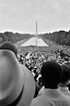
Crowds surrounding the Reflecting Pool during the 1963 March on Washington.
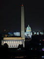
Night view of The Lincoln Memorial, Washington Monument and U.S. Capitol, 2007.


Law and government
Local government

The city is run by an elected mayor and a district council. The council is composed of 13 members: One elected from each of the eight wards and five members, including the chairman, elected at large. The council conducts its work through standing committees and special committees established as needed. District schools are administered by a school board that has both elected and appointed members. There are 37 elected Advisory Neighborhood Commissions that provide the most direct access for residents to their local government. The commissions serve as local councils, and their suggestions are required to be given "great weight" by the D.C. Council. However, the U.S. Congress has the right to review and overrule laws created locally and has often done so.
D.C. residents pay federal taxes, such as income tax, as well as high local taxes. The mayor and council adopt a budget of local money with Congress reserving the right to make any changes. Much of the valuable property in the District is federally owned and hence exempt from local property taxes; at the same time, the city is burdened with the extraordinary expenses related to its role as the capital, such as police overtime and street cleaning for D.C.'s frequent parades and festivals. These factors are often used to explain why the city's budget is frequently overstretched. However, the federal government also appropriates funds for the city. For instance, the federal government provided an estimated 25 percent of the District's operating budget in 2003.
Representation in federal government

The U.S. Constitution gives Congress direct jurisdiction over Washington, D.C. While Congress has delegated various amounts of this authority to local government, including an elected mayor and city council, Congress still intervenes, from time to time, in local affairs relating to schools, gun control policy, and other issues.
Citizens of the District have no voting representation in Congress. They are represented in the House of Representatives by a non-voting delegate who sits on (and can even chair) committees and participates in floor debate but cannot vote on final passage of any legislation. Walter Fauntroy was the first D.C. Delegate to the House and served for 20 years (from March 23, 1971 – January 3, 1991). D.C. has no representation in the Senate. Attempts to change this situation, including statehood and the proposed District of Columbia Voting Rights Amendment, have been unsuccessful. However, unlike U.S. territories (such as American Samoa and Guam), citizens of the District of Columbia are fully taxed and subject to all U.S. laws. In recent years, "Taxation Without Representation" has been the motto placed on D.C. license plates.
With the passage of the 23rd Amendment in 1961, residents of the District became eligible to vote for president.
Domestic partnerships
The District of Columbia has recognized domestic partnerships since 1992, but Congress withheld funding to implement recognition until 2002. Both same-sex and mixed-sex couples may register. Under the Domestic Partnership Equality Amendment Act of 2006, D.C. Law 16-79, which came into effect on April 4, 2006, in almost all cases a domestic partner will have the same rights as a spouse regarding inheritance, probate, guardianship, and other rights traditionally accorded to spouses. Employees of the District government and their domestic partners are eligible for healthcare coverage and family leave benefits, the same as married couples.
Crime
Crime in Washington, D.C., is concentrated in areas associated with poverty, drug abuse, and gangs. The more affluent neighborhoods of Northwest Washington are typically safe, especially in areas with concentrations of government operations, such as Downtown Washington, D.C., Foggy Bottom, Embassy Row, and Penn Quarter.
During the violent crime wave of the early 1990s, Washington, D.C., was known as the "murder capital" of the United States, and often rivaled New Orleans in the high number of homicides. But the level of violence declined drastically in the 1990s.
In 2012, Washington's annual murder count had dropped to 88, the lowest total since 1961.[12] The murder rate has since risen from that historic low, though it remains below its highest number, and there has been a decrease in overall violent crime and property crime.[13]
Many neighborhoods such as Columbia Heights and Logan Circle have become safer and vibrant. However, incidents of robberies and thefts have remained higher in these areas because of increased nightlife activity and greater numbers of affluent residents.[14]
In addition to the District's own Metropolitan Police Department, many federal law enforcement agencies have jurisdiction in the city as well – most visibly the U.S. Park Police.[15]
Economy
Washington, D.C. has a growing economy that is also diversifying, with the percentage of federal government jobs expected to decrease over the next decade and an increasing percentage of professional and business service jobs over the same period. With six Fortune 1000 companies (two of which are also Fortune 500 companies), and a large support infrastructure of professional services, including law, public relations, and architecture, Washington, D.C. has become a leading city for global real estate investment, behind London, New York City, and Paris.
The presence of major government agencies has led to business development in the region.[16] These businesses include federal contractors (defense and civilian), numerous nonprofit organizations, law firms and lobbying firms, national associations of labor and professional groups, catering and administrative services companies, and other industries that are sustained by the economic presence of the federal government.
Washington, D.C.'s financial regulatory environment is making the city more competitive as a jurisdiction for captive insurance companies and financial institutions to locate and do business. This increasingly popular form of alternative insurance allows large corporations and industry associations to create independent insurance companies to insure their own risks.
Other than the government, major universities and hospitals are among the top employers, with the George Washington University, Georgetown University, and Washington Hospital Center as the top three.
Transportation

Several major interstates run through the area, intersecting with other major highways. The American Automobile Association for several years has ranked the Washington metro area as having the nation's second worst traffic congestion, surpassed only by Los Angeles.
The Washington area is served by the Washington Metropolitan Area Transit Authority (WMATA), which operates the region's subway system, the nation's second-busiest after New York City's subway, as well as Metrobus, which serves D.C. and the immediate closest counties.
Washington, D.C., is served by three major airports; one in Maryland and two in Virginia. Ronald Reagan Washington National Airport is the closest and is accessible by the Washington Metro. Most major international flights arrive and depart from Washington Dulles International Airport, located 26.3 miles (42.3 km) west of the city in Virginia. Dulles is the second busiest international gateway on the East Coast. Baltimore-Washington International Thurgood Marshall Airport is located 31.7 miles (51.0 km) northeast of the city near Baltimore, Maryland.
Demographics


Washington has had a significant African American population since the city's foundation.[17] The black population reached a peak of 70 percent by 1970, but has since steadily declined due to many African Americans moving to the surrounding suburbs. Partly as a result of gentrification, there was a significant increase in the non-Hispanic white population and a decrease in the black population between 2000 and 2010.[18]
Education
Elementary and secondary
District of Columbia Public Schools (DCPS) operates the city's public school system, which consists of 167 schools and learning centers. The city had one of the highest-cost yet lowest-performing school systems in the country, both in terms of infrastructure and student achievement. After taking office in 2006, Mayor Adrian Fenty and Chancellor Michelle A. Rhee made sweeping changes to the system by closing schools, replacing teachers, firing principals, and using private education firms to aid curriculum development.[19]
Due to the perceived problems with the traditional public school system, enrollment in public charter schools and private schools is high.
Colleges and universities

Washington D.C. is home to many notable universities, both public and private, including The George Washington University (GW), Georgetown University (GU), American University (AU), The Catholic University of America (CUA), and The Johns Hopkins University School of Advanced International Studies (SAIS), a graduate school. The University of the District of Columbia (UDC) provides public postsecondary education. It is the nation's only urban land-grant university and is counted among the historically black colleges and universities. CUA is unique as the national university of the Roman Catholic Church and as the only higher education institution founded by U.S. Roman Catholic bishops.
Other notable private colleges in the District include Gallaudet University, the first liberal arts college for the deaf and hard-of-hearing, and Howard University, a historically black university dating to the nineteenth century that, among other achievements, trained many early black physicians.
Culture

Tourism
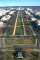
Washington is home to numerous national landmarks and is one of the most popular tourist destinations in the United States. The National Mall is a large, open park area. Located prominently in the center of it is the Washington Monument. Other notable points of interest near the Mall include the Jefferson Memorial, Lincoln Memorial, Franklin Delano Roosevelt Memorial, National World War II Memorial, Korean War Veterans Memorial, and Vietnam Veterans Memorial.
The world-famous Smithsonian Institution is based in the District. The Smithsonian today is a collection of museums that includes the Arthur M. Sackler Gallery, Hirshhorn Museum and Sculpture Garden, National Air and Space Museum, National Museum of American History, National Museum of the American Indian, National Museum of Natural History, National Portrait Gallery, and National Zoo.
There are many art museums in D.C., in addition to those that are part of the Smithsonian, including the National Gallery of Art, National Museum of Women in the Arts, Corcoran Gallery of Art, and Phillips Collection.
The Library of Congress and the National Archives house thousands of documents covering every period in American history, including the Declaration of Independence, Constitution, and Bill of Rights.
Performing arts
Washington is a major national center for the arts, with many venues for the performing arts in the city. The John F. Kennedy Center for the Performing Arts hosts the National Symphony Orchestra, the Washington National Opera, the Washington Ballet, and a variety of other musical and stage performances.


Several notable local music clubs are all in the U Street area. D.C. has its own native music genre, called go-go, a post-funk, percussion-driven flavor of R&B that blends live sets with relentless dance rhythms, so-called because they "go and go and go." Washington was also an important center in the genesis of punk rock in the United States. The region also has a significant indie rock history.
Sports
| Club | Sport | League | Venue |
|---|---|---|---|
| D.C. United | Soccer | Major League Soccer, Eastern Conference | RFK Stadium |
| Washington Capitals | Hockey | NHL, Eastern Conference, Southeast Division | Verizon Center |
| Washington Mystics | Basketball | WNBA, Eastern Conference | Verizon Center |
| Washington Nationals | Baseball | Major League Baseball; NL, East Division | National Stadium |
| Washington Redskins | Football | National Football League; NFC, East Division | FedExField (Landover, Maryland) |
| Washington Wizards | Basketball | NBA; Eastern Conference, Southeast Division | Verizon Center |
Washington hosts the annual Legg Mason Tennis Classic tennis tournament. The Marine Corps Marathon and the National Marathon are both held annually in Washington.
Media
Newspapers
The Washington Post is the oldest and most-read daily newspaper in Washington. The more conservative daily, The Washington Times, also has substantial readership. Two free daily newspapers, The Washington Examiner and Express are also distributed, the latter owned by the Washington Post. Several specialty weekly newspapers serve the U.S. Congress and those who work with it; most notable are Roll Call and The Hill. Numerous national and international media outlets maintain bureaus in Washington, some of whose offices at the National Press Club building.
Television
The metro area is served by several local broadcast television stations and is the eighth largest designated market area, with 2,252,550 homes (2.04 percent of the U.S. population). Most Baltimore area television stations can be seen in the Washington region.
Several cable television networks have their headquarters in the Washington area, including C-SPAN, Black Entertainment Television (BET), National Geographic Channel, and Discovery Communications, as well as the Public Broadcasting Service (PBS) in Virginia. Major national broadcasters and cable outlets including NBC, ABC, CBS, FOX, and CNN maintain a significant presence in Washington, as do those from around the world including the BBC, CBC, and Al Jazeera.
Radio

There are several major radio stations serving the metro area, with a wide variety of musical interests as well as talk and sports. There are two National Public Radio (NPR) affiliates. Most major radio stations from Baltimore can be heard in the Washington metropolitan area. XM Satellite Radio and NPR are based in Washington. Voice of America, the U.S. government's international broadcasting service, is headquartered in Washington.
Health care
The District's 16 medical centers and hospitals make it a national center for patient care and medical research. Washington Hospital Center (WHC), the largest hospital campus in the District, is both the largest private and largest non-profit hospital in the Washington area. Immediately adjacent to it is the Children's National Medical Center, among the highest-ranked pediatric hospitals in the country. Many of the city's prominent universities, including George Washington, Georgetown, and Howard, have medical schools and associated teaching hospitals. Walter Reed Army Medical Center provides care for active-duty and retired personnel and their dependents, as well as the president, vice president, and congressmen. The hospital is scheduled to move to a newer and larger facility, forcing its closure in 2011. Veterans also receive care at the Veterans' Affairs Medical Center.
However, the District's hospital services are poorly distributed geographically: all of the District’s trauma facilities are clustered in the Northwest quadrant, while 42 percent of the District’s population live in the eastern sectors, where there are no trauma facilities of any kind.
Notes
- ↑ Population estimates, July 1, 2019, (V2019) QuickFacts District of Columbia, United States Census Bureau. Retrieved January 27, 2020.
- ↑ Ulysses Simpson Grant III, "Planning the Nation's Capital," Records of the Columbia Historical Society 50 (1950): 43–58.
- ↑ Cities with the largest parkland percentage of the city area in the United States in 2018 Statista. Retrieved January 28, 2020.
- ↑ Chesapeake and Ohio Canal National Historic Park: History & Culture National Park Service. Retrieved January 28, 2020.
- ↑ About the Festival National Cherry Blossom Festival. Retrieved January 28, 2020.
- ↑ AIA Reveals Public’s Choice America’s Best Architecture American Institute of Architects. Retrieved January 28, 2020.
- ↑ Washington, D.C. List of Sites. National Park Service. Retrieved January 28, 2020.
- ↑ Pamela Scott, Residential Architecture of Washington, D.C., and Its Suburbs Library of Congress, 2005. Retrieved January 28, 2020.
- ↑ Old Stone House National Park Service.
- ↑ About Us Ronald Reagan Building and International Trade Center. Retrieved January 28, 2020.
- ↑ Bob Arnebeck, Was Washington Built on a Swamp? Retrieved January 28, 2020.
- ↑ Andrew Mollenbeck, District celebrates historically low homicide rate WTOP, January 3, 2013. Retrieved January 28, 2020.
- ↑ Crime rate in Washington, District of Columbia (DC) City-data.com. Retrieved January 28, 2020.
- ↑ Allison Klein and Dan Keating, Liveliest D.C. Neighborhoods Also Jumping With Robberies The Washington Post, October 13, 2006. Retrieved January 28, 2020.
- ↑ Jurisdiction and Authority United States Park Police, Nation Park Service, February 25, 2015. Retrieved January 28, 2020.
- ↑ Gerald Perrins and Diane Nilsen, Industry dynamics in the Washington, DC, area: Has a second job core emerged? Monthly Labor Review, December 2006. Retrieved January 28, 2020.
- ↑ Peter Kolchin, American Slavery (Hill and Wang, 2003, ISBN 978-0809016303).
- ↑ Carol Morello and Dan Keating, Number of black D.C. residents plummets as majority status slips away The Washington Post, March 24, 2011. Retrieved January 28, 2020.
- ↑ V. Dion Haynes and Bill Turque, Rhee Offers Plan To Improve D.C.'s Troubled Schools The Washington Post, May 16, 2008. Retrieved January 28, 2020.
ReferencesISBN links support NWE through referral fees
- Kohler, Sue A., and Pamela Scott. Designing the Nation's Capital: The 1901 Plan for Washington, D.C. Washington, DC: U.S. Commission of Fine Arts, 2006. ISBN 9780160752230.
- Kolchin, Peter. American Slavery. Hill and Wang, 2003. ISBN 978-0809016303
- National Park Service. The L'Enfant and MacMillan Plans for Washington, D.C.
- USGS. District of Columbia Retrieved January 27, 2020.
External links
All links retrieved May 3, 2023.
- Official Government Website
- Washington, D.C. Convention and Tourism Corporation
- Guide to Washington, D.C., Materials from the Library of Congress
- Boundary Stones of the District of Columbia
| Political divisions of the United States | |||||||
|---|---|---|---|---|---|---|---|
| |||||||
Credits
New World Encyclopedia writers and editors rewrote and completed the Wikipedia article in accordance with New World Encyclopedia standards. This article abides by terms of the Creative Commons CC-by-sa 3.0 License (CC-by-sa), which may be used and disseminated with proper attribution. Credit is due under the terms of this license that can reference both the New World Encyclopedia contributors and the selfless volunteer contributors of the Wikimedia Foundation. To cite this article click here for a list of acceptable citing formats.The history of earlier contributions by wikipedians is accessible to researchers here:
The history of this article since it was imported to New World Encyclopedia:
Note: Some restrictions may apply to use of individual images which are separately licensed.