Connecticut
| State of Connecticut | |||||||||||
| |||||||||||
| Official language(s) | None | ||||||||||
| Capital | Hartford | ||||||||||
| Largest city | Bridgeport[3] | ||||||||||
| Largest metro area | Greater Hartford | ||||||||||
| Area | Ranked 48th | ||||||||||
| - Total | 5,543 sq mi (14,357 km²) | ||||||||||
| - Width | 70 miles (113 km) | ||||||||||
| - Length | 110 miles (177 km) | ||||||||||
| - % water | 12.6 | ||||||||||
| - Latitude | 40°58′ N to 42°03′ N | ||||||||||
| - Longitude | 71°47′ W to 73°44′ W | ||||||||||
| Population | Ranked 29th in the U.S. | ||||||||||
| - Total | 3,580,709 (2011 est)[4] | ||||||||||
| - Density | 739/sq mi (285/km2) Ranked 4th in the U.S. | ||||||||||
| - Median income | $68,595 (3rd) | ||||||||||
| Elevation | |||||||||||
| - Highest point | Massachusetts border on south slope of Mount Frissell[5][6] 2,379 ft (725 m) | ||||||||||
| - Mean | 500 ft (150 m) | ||||||||||
| - Lowest point | Long Island Sound[5][6] 0 ft (0 m) | ||||||||||
| Admission to Union | January 9, 1788 (5th) | ||||||||||
| Governor | Dannel Malloy (D) | ||||||||||
| Lieutenant Governor | Nancy Wyman (D) | ||||||||||
| U.S. Senators | Joe Lieberman (ID) Richard Blumenthal (D) | ||||||||||
| Time zone | Eastern: UTC-5/-4 | ||||||||||
| Abbreviations | CT Conn. US-CT | ||||||||||
| Web site | www.ct.gov | ||||||||||


Connecticut is one of the Unites States. It is located in the New England region of the northeastern United States of America. Connecticut is the 29th most populous state with 3.4 million residents and is ranked 48th in size by area. Connecticut is the fourth most densely populated state. Only Delaware and Rhode Island are smaller in total area.
Connecticut has a long history dating from early colonial times. Its Fundamental Orders of 1639 are considered to be the first written constitution in the Americas. The orders were influential in the development of early American government. Connecticut's was one of the thirteen original colonies and in 1788 became the fifth state to join the fledgling United States. Its nickname is "The Constitution State." It is also the home of Yale University, founded in 1701. Yale is an Ivy league university and is consistently ranked as one of the world's top universities.
The state's first European settlers were from the Netherlands. However, the first major settlements were established in the 1630s by English settlers who moved overland from Massachsetts Bay Colony. The immigration from Massachusetts formed three disparate colonies; River Colony (Hartford), Old Saybrook, and Quinnipiack (New Haven). Those colonies merged in 1662 under a royal charter making Connecticut a crown colony.
Connecticut's temperate climate and long coastline on Long Island Sound have given the state a deep maritime tradition. Modern Connecticut is known for its wealth, initially based on industry. Financial organizations have flourished in the state. First insurance companies in Hartford, then hedge funds. This prosperity has helped give Connecticut the highest per capita income and median household income and some of the highest taxes in the country.
Notable figures from the state span American political and cultural history, including Roger Sherman, Benedict Arnold, Nathan Hale, Eli Whitney, John Brown, Harriet Beecher Stowe, Mark Twain, Charles Ives, Eugene O'Neill, and Katharine Hepburn.
Geography

Connecticut is bordered on the south by Long Island Sound, on the west by New York, on the north by Massachusetts, and on the east by Rhode Island. The state capital is Hartford, and the other major cities include New Haven, New London, New Britain, Norwich, Milford, Norwalk, Stamford, Waterbury, Danbury, and Bridgeport, the largest.
The highest elevation in Connecticut is Mount Frissell in the northwestern corner of the state. The peak and northern part of the mountain are located within Massachusetts. The southern slope of Mount Frissell is located within Connecticut and the highest elevation within the state is 2,379 ft (725 m). Bear Mountain, located 1.3 miles (2.1 km) to the east, is the highest mountain summit in Connecticut.
The Connecticut River cuts through the center of the state, flowing into Long Island Sound, Connecticut's outlet to the Atlantic Ocean.
Despite its size, the state has regional variations in its landscape and culture, from the wealthy estates of Fairfield County's "Gold Coast" to the rolling mountains and horse farms of northwestern Connecticut. Connecticut's rural areas and small towns in the northeast and northwest corners of the state contrast sharply with its industrial cities, located along the coastal highways, US Route 84 and US Route 95, from the New York border to New Haven, then northward to Hartford, as well as farther up the coast near New London. Many towns center around a small park, known as a "green." Near the green one may stand a small white church, a town meeting hall, a tavern, and several colonial houses. Forests, rivers, lakes, waterfalls, and a sandy shoreline add to the state's beauty.
The state shares its northern boundary with Massachusetts is marked by the distinctive Southwick Jog/Granby Notch, an approximately 2.5-mile (4.0 km) square detour into Connecticut slightly west of the center of the border. The southwestern border of Connecticut, where it abuts New York, is marked by a panhandle in Fairfield County. This irregularity in the boundary is the result of territorial disputes in the late 1600s.[7]
Climate
Connecticut has a humid continental climate, with seasonal extremes tempered by its proximity to the Atlantic Ocean. Winters are cold, and the average yearly snowfall is about 25–100 inches (64–254 cm) across the state, with higher totals in the northwest. Spring has variable temperatures with frequent rainfall. Summer is hot and humid throughout the state. Autumn months are mild. During hurricane season, tropical cyclones occasionally affect the region. Thunderstorms are most frequent during the summer, occurring on average 30 times annually. These storms can be severe, though tornadoes are rare.
Flora and fauna
Forests cover about 60 percent of Connecticut, made up of elm, ash, maple, beech, birch, and oak trees. White-tailed deer, foxes, beavers, minks, and squirrels are among the mammals found in the state. Saltwater and freshwater fish live in the state's waters. Sandy Point Bird Sanctuary provides 3 and a half miles of beach where wildlife can be enjoyed in a recreational environment of walking, hiking and biking. Connecticut Audubon Society’s Coastal Center at Milford Point is a birdwatchers' paradise, where 315 bird species can be found.
History

The name "Connecticut" originates from the Mohegan word quinnitukqut, meaning "place of long tidal river." [8] Among the hundreds of Native American tribes living in the region were the Mohegan, Niantic, Podunk, Quinnipiac, Pequot, and Nipmuc.
European contact
The first European in Connecticut was the Dutch explorer Adriaen Block, who arrived in 1614. Dutch fur traders sailed up the Connecticut River and built a fort near present-day Hartford.
The first English settlers came in 1633 and settled at Windsor and then Wethersfield in 1634. However, the main body of settlers came in one large group in 1636. The settlers were Puritans from Massachusetts, led by Thomas Hooker. Hooker had been prominent in England and was a professor of theology at Cambridge. He was also an important political writer and made a significant contribution to constitutional theory. He broke with the political leadership in Massachusetts, and, just as Roger Williams had created a new polity in Rhode Island, Hooker and his cohort did the same and established the Connecticut Colony at Hartford in 1636.
John Winthrop, then of Massachusetts, gained permission to create a new colony at Old Saybrook at the mouth of the Connecticut River in 1635. This was the second of three distinct colonies that later would be combined to make up Connecticut. Saybrook Colony was a direct challenge to Dutch claims. The colony was not more than a small outpost and never matured. In 1644, the Saybrook Colony merged itself into the Connecticut Colony. Because the Dutch were outnumbered by the flood of English settlers from Massachusetts, they abandoned their fort in 1654.
The third colony was founded in 1638. New Haven Colony, (originally known as the Quinnipiack Colony), had its own constitution, 'The Fundamental Agreement of the New Haven Colony' which was signed on June 4, 1639.

Neither the establishment of the Connecticut Colony nor the Quinnipiack Colony were done with the sanction of British imperial authorities, and were independent political entities. They naturally were presumptively English, but in a legal sense, they were only secessionist outposts of Massachusetts Bay Colony. In 1662, Winthrop took advantage of this void in political affairs and obtained in England the charter by which the colonies of Connecticut and Quinnipiack were united. Although Winthrop's charter favored the Connecticut colony, New Haven remained a seat of government with Hartford until after the American Revolution. The politically astute Winthrop secured the charter from the newly restored Charles II, who granted him liberal political terms.
Its first constitution of Connecticut, the "Fundamental Orders," was adopted in 1639. Connecticut is the fifth of the original thirteen states. Its original constitutions influenced the U.S. Constitution, as one of the leading authors was Roger Sherman of New Haven.
Initial good relations between the Native Americans and the settlers became tense over their differing uses of the land and erupted into violence in 1637, when the colonists massacred the Pequot, formerly the most powerful tribe. King Philip's War in Rhode Island and diseases brought by the Europeans nearly wiped out the remaining native peoples.
The western boundaries of Connecticut have been subject to change over time. According to a 1650 agreement with the Dutch, the western boundary of Connecticut ran north from the west side of Greenwich Bay "provided the said line come not within 10 miles [16 km] of Hudson River." On the other hand, Connecticut's original Charter granted it all the land to the "South Sea," i.e., the Pacific Ocean. Connecticut took its grant seriously, and established a county between the Susquehanna and Delaware Rivers. This resulted in the brief Pennamite Wars with Pennsylvania.
Connecticut's lands also extended across northern Ohio, called the Western Reserve lands. The Western Reserve section was settled largely by people from Connecticut. Agreements with Pennsylvania and New York extinguished the land claims by Connecticut within its neighbors, and the Western Reserve lands were relinquished to the federal government, which brought the state to its present boundaries.
Modern times
Before and after the American Civil War, immigrants from other countries flooded into Connecticut to work in the new mills and factories that were producing textiles and guns, and later, electrical products and machines. Defense-related industries are a major part of the economy. Sikorsky Aircraft Corporation builds military helicopters, and Pratt & Whitney makes jet engines. Other companies supply submarines, radar, and other items needed by the military.
Government and politics

Hartford has been the sole capital of Connecticut since 1875. Prior to that time, it served as co-capital with the city of New Haven.
Constitutional history
Connecticut is known as the “Constitution State.” The nickname is assumed to reference the Fundamental Orders of 1638–1639, which represent the framework for the first formal government written by a representative body in Connecticut.
After the Fundamental Orders, Connecticut was granted governmental authority by King Charles II of England through the Connecticut Charter of 1662. While these two documents acted to lay the ground work for the state’s government, both lacked essential characteristics of a constitution. The Fundamental Orders and the Connecticut Charter could both be altered simply by a majority vote of the General Assembly. Separate branches of government did not exist during this period, and the General Assembly acted as the supreme authority. A true constitution was not adopted in Connecticut until 1818. Finally, the current state constitution was implemented in 1965. The 1965 constitution absorbed a majority of its 1818 predecessor, but incorporated a handful of important modifications. Another possible source of the nickname "Constitution State" comes from Connecticut's pivotal role in the federal constitutional convention of 1787, during which Roger Sherman and Oliver Ellsworth helped to orchestrate what became known as the Connecticut Compromise, or the Great Compromise. This plan combined the Virginia Plan and the New Jersey Plan to form a bicameral legislature, a form copied by almost every state constitution since the adoption of the federal Constitution.
Executive
The governor heads the executive branch. Connecticut was the first state in the United States to elect a woman as governor without electing her husband first, Ella Grasso in 1974.
In addition to the governor and lieutenant governor, four other executive officers are elected directly by voters: Secretary of State, Treasurer, Comptroller, and Attorney General. All executive officers are elected to four year terms.
Legislative
| Connecticut State symbols |
|
The legislature is the General Assembly. The General Assembly is a bicameral body consisting of an upper body, the State Senate (36 senators); and a lower body, the House of Representatives (151 representatives). Senators and representatives are elected to two-year terms in even-numbered years. The Democrats in 2008 hold the majority in both houses of the General Assembly. At the same time, Connecticut had five representatives in the U.S. House, four of whom were Democrats.
Judicial
The highest court of Connecticut's judicial branch is the Supreme Court, headed by the Chief Justice. The Supreme Court is responsible for deciding on the constitutionality of the law or cases as they relate to the law. The Appellate Court is a lesser state-wide court, and the Superior Courts are lower courts that resemble county courts of other states.
Local government
Connecticut has 169 towns, which serve as the fundamental local political subdivision of the state; the entire state is divided into towns. Connecticut shares a local form of government with the rest of New England called the New England town. There are also 21 cities, most of which are coterminous with their namesake towns and have a merged city-town government. There are also nine incorporated boroughs, which may provide additional services to a section of town.[9]
Unlike most other states, Connecticut does not have a system of county governments; most were eliminated in 1960. The state is instead divided into 15 planning regions defined by the state Office of Planning and Management. [10] Each region has an administrative body known as either a regional council of governments, a regional council of elected officials, or a regional planning agency. The regions are established for the purpose of planning "coordination of regional and state planning activities; designation or redesignation of logical planning regions and promotion of the continuation of regional planning organizations within the state; and provision for technical aid and the administration of financial assistance to regional planning organizations."[10]
Politics
Connecticut allotted its electoral votes exclusively to Democratic candidates since the 1990s, but to Republican presidential candidates five times in the 1970s and 1980s. There are a large number of voters who are not registered with a major party. As of 2004, 33.7 percent of registered voters were registered Democratic, 22.0 percent were registered Republican, and 44.0 percent were unaffiliated with any party.[11] Voters in the state tend to be more supportive of fiscal conservatives and may be considered to be generally socially liberal.
Democrats hold veto-proof majorities in both houses of the state legislature. In 2006, Republicans were reduced from three out of five to one out of five congressional seats. Lowell P. Weicker, Jr., who served in the U.S. Senate from 1971 to 1989, was the last Connecticut Republican to serve as senator. He was known as a liberal Republican who broke with then-President Richard Nixon during Watergate and successfully ran for governor in 1990 as an independent. Before Weicker, the last Republican to represent Connecticut in the Senate was Prescott Bush, the father of former President George H. W. Bush and the grandfather of President George W. Bush. He served from 1953 to 1963.
Connecticut politics were tarnished by corruption in the late 1990s and early years of the twenty-first century. The list includes several mayors, state legislators, and government employees who have been found, or plead, guilty to a string of crimes ranging from bribery to racketeering.[12]
Economy

The total gross state product for 2004 was $187 billion. The per capita income for 2005 was $47,819, ranking first among the states.[13] There is, however, a great disparity in incomes through the state; although New Canaan has one of the highest per capita incomes in America, Hartford is one of the ten cities with the lowest per capita incomes in the country. The low number may partially be due to the fact that the city, like other cities in the area, has a small footprint relative to a typical American city (only about 18 square miles) and therefore does not have more middle-income areas included in its total to "balance out," statistically, inner areas with older housing stock and a poorer population.
Should Hartford (or similar cities New Haven and Bridgeport) be combined with its immediate suburbs, it would rank as one of the richest cities in the country. Fairfield County has become a bedroom community for higher-paid New York City workers seeking a less urban lifestyle. This in turn has attracted businesses wishing to remain near New York City to southwestern Connecticut, most notably to Stamford.
New Canaan is the wealthiest town in Connecticut, with a per capita income of $85,459. Hartford is the poorest city in Connecticut, with a per capita income of $13,428. There are other lower-income and blue-collar towns, mostly parts of towns, in the eastern part of the state. Poor and medium wealth households are particularly affected by a very high cost of living, due to a combination of expensive real estate, expensive heating for the winters, and other factors.
Taxation

Prior to 1991, Connecticut had a highly populist income tax system. Income from employment was untaxed, but income from investments was taxed at the highest rate in the United States: 13 percent. This burden was further increased by the method of calculation: no deductions were allowed for the cost (for example, interest on borrowing) of producing the investment income. Under Governor Lowell P. Weicker, Jr., an Independent, this was reformed to the present system.
This system prior to 1991 made it an attractive haven for high-salaried earners fleeing the heavy taxes of New York State, but highly unattractive for members of Wall Street partnerships. It put an enormous burden on Connecticut property tax payers, particularly in the cities with their more extensive municipal services. As a result, the middle class largely fled the urban areas for the suburbs, taking stores and other tax-paying businesses with them, leaving mostly the urban poor in the older, central areas of Connecticut cities.
With Weicker's 1991 tax reform, the tax on employment and investment income was equalized at a then-maximum of 4 percent. Since then, the city of Greenwich has become the headquarters of choice for a large number of America's largest hedge funds, and Connecticut income from that industry has soared. In the early years of the twenty-first century, the income tax rate on Connecticut individuals was divided into two tax brackets of 3 percent and 5 percent.
Real estate
Homes in southwestern Connecticut on the fringes of the New York City metropolitan area are relatively expensive. Many towns have median home prices over $500,000, with some more desirable homes exceeding $1 million. Greenwich has the most expensive real estate market, with most houses selling at over $1 million and most condos selling at over $600,000. Connecticut has the most million-dollar homes in the Northeast, and the second most in the nation after California, with 3.3 percent of homes in Connecticut priced over one million dollars in 2003.[14] In 2007, the median price for a house in Connecticut passed $300,000 for the first time, even though most of the country was mired in a real estate slump.
Industries

The insurance industry is one of the biggest employers in Hartford. More than a hundred insurance companies are based in the state.
The agricultural output for the state is nursery stock, eggs, dairy products, cattle, and tobacco. Commercial fishing is also a big industry. Connecticut is one of the country's top producers of oysters, but lobster, flounder, shad, and other fish are also caught.
Its industrial outputs are transportation equipment (especially helicopters, aircraft parts, and nuclear submarines), heavy industrial machinery and electrical equipment, military weaponry and fabricated metal products, chemical and pharmaceutical products, and scientific instruments.
A report issued by the Connecticut Commission on Culture & Tourism in 2006 demonstrated that the economic impact of the arts, film, history, and tourism generated more than $14 billion in economic activity and 170,000 jobs annually.[15]
Transportation
Between New Haven and the New York City, I-95 is one of the most congested highways in the United States. Since many Connecticut residents commute to New York City, there is an extensive commuter railway network connecting New York City to New Haven, with spurs servicing Waterbury, Danbury, and New Canaan. Regional rail service is provided by Amtrak.
Education
With such a diverse population, Connecticut is introducing programs in the public schools to best meet the needs of its varied student body.
Approximately 80 percent of the state's high school graduates attend college. The institutions of higher learning include Yale University, the U.S. Coast Guard Academy, the University of Connecticut, and the University of Bridgeport.
Demographics

As of 2005, Connecticut had an estimated population of 3,510,297,[16] which is an increase of 11,331, or 0.3 percent, from the prior year and an increase of 104,695, or 3.1 percent, since the year 2000. Based on the 2005 estimates, Connecticut moves from the 29th most populous state to 30th.
In 1790, 97 percent of the population in Connecticut were classified as "rural." The first census in which less than half the population was classified as rural was 1890. In the 2000 census, it was only 12.3 percent. Most of western and southern Connecticut is strongly associated with New York City; this area is the most affluent and populous region of the state. A portion of rural northeastern Connecticut is somewhat culturally influenced by Boston.
Race, ancestry, and language
As of 2004, 11.4 percent of the population (400,000) was foreign-born, and 10 percent of the foreign-born in the state were illegal aliens (about 1.1 percent of the population). In 1870, native-born Americans had accounted for 75 percent of the state's population, but that had dropped to 35 percent by 1918.
As of 2000, 81.69 percent of Connecticut residents age 5 and older spoke English at home and 8.42 percent spoke Spanish, followed by Italian, French, and Polish.[17]
The five largest reported ancestries in the state are: Italian (18.6 percent), Irish (16.6 percent), English (10.3 percent), German (9.9 percent), and French/French Canadian (9.9 percent).
Connecticut has large Italian-American and Irish-American populations, as well as German and Portuguese-American, second highest percentage of any state behind Rhode Island (19.3 percent). African Americans and Hispanics (mostly Puerto Ricans) are numerous in the urban areas of the state. Connecticut also has a sizable Polish American population.
More recent immigrant populations include those from Laos, Vietnam, Thailand, Indonesia, Mexico, Brazil, Guatemala, Panama, and former Soviet countries.
Religion
A 2001 survey of Connecticut residents' religious self-identification showed the following distribution of affiliations:[18]
- Roman Catholic – 32 percent
- Protestant (various denominations) - 45 percent
- Jewish – 1 percent
- Muslim – 1 percent
- Other Religions – 4 percent
- Non-Religious – 12 percent
- No answer – 6 percent
Looking to the future
Maintaining clean water and air are two major challenges facing the state. The federal and state governments are setting limits on dumping chemical wastes into the water supply and emitting automobile exhausts and smoke. Making the beaches safer for swimming is important for tourism.
With much of southern Connecticut becoming a bedroom community for New York City, transportation and congestion are major issues. New Canaan is the wealthiest town in Connecticut, with a per capita income of $85,459. Hartford, on the other hand, is the poorest city in Connecticut, with a per capita income of $13,428. There are other lower-income and blue-collar towns in the eastern part of the state. Poor and medium wealth households are particularly affected by a very high cost of living, due to a combination of expensive real estate, high fuel costs for heating in the winter, and other factors.
Areas of inner-city blight and abandoned housing exists in the Connecticut’s larger cities, though urban redevelopment programs have made progress. There continues to be a shortage of lower- and middle-income housing. New Haven's 1950s and 1960s renewal programs became a prototype for the rest of the country.
Connecticut has provided relatively generous welfare benefits. Elderly and children's services have special departments, but the state has joined the national effort to reduce welfare costs. The state is renowned for its elite schools and universities, but its public elementary and secondary schools have been underfunded, and continue to reflect the racial imbalance of residential patterns.
While the state provides a variety of landscapes; beaches, forested hills, rocky headlands, and idyllic small towns with well-preserved historic buildings, there is a lack of balance in its wealth and many very low-income residents.
Notes
- ↑ Connecticut's Nicknames Connecticut State Library.
- ↑ 2.0 2.1 Error on call to template:cite web: Parameters url and title must be specified.
- ↑ Population Estimates for All Places: 2000 to 2006: Connecticut SUB-EST2006-04-09.xls. United States Census Bureau.
- ↑ Error on call to template:cite web: Parameters url and title must be specified (CSV). 2011 Population Estimates. United States Census Bureau, Population Division (December 2011).
- ↑ 5.0 5.1 Elevations and Distances in the United States. United States Geological Survey (2001). Retrieved October 21, 2011.
- ↑ 6.0 6.1 Elevation adjusted to North American Vertical Datum of 1988.
- ↑ Connecticut State Library. Connecticut's "Panhandle".
- ↑ State of Connecticut. About Connecticut Retrieved October 27, 2008.
- ↑ Connecticut State Library. Connecticut's Boroughs and Cities.
- ↑ 10.0 10.1 State of Connecticut. Regional Planning Coordination Retrieved October 27, 2008.
- ↑ Connecticut Office of the Secretary of State. Party Enrollment in Connecticut.
- ↑ Mike Pesca. November 9, 2007. Connecticut Politics Tarnished by Corruption NPR. Retrieved October 27, 2008.
- ↑ Bureau of Economic Analysis. Per Capita Income Growth in 2005 Retrieved October 27, 2008.
- ↑ Les Christie. February 23, 2006. Million dollar homes CNN.com. Retrieved October 27, 2008.
- ↑ Connecticut Commission on Culture & Tourism. Culture and Tourism Retrieved October 27, 2008.
- ↑ U.S. Census Bureau national and state population estimates.
- ↑ The Modern Language Association. Most spoken languages in Connecticut Retrieved October 27, 2008.
- ↑ City University of New York. American Religious Identification Survey Retrieved October 27, 2008.
ReferencesISBN links support NWE through referral fees
- Gelman, Amy. 2002. Connecticut. Minneapolis, MN: Lerner Publications. ISBN 0822540770
- Kent, Zachary. 2008. Connecticut. New York: Children's Press. ISBN 9780531185711
- U.S. Census Bureau. State & County QuickFacts Retrieved October 27, 2008.
- United States Geological Survey. Science In Your Backyard: Connecticut Retrieved October 27, 2008.
Gallery of images

New London
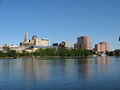
Hartford
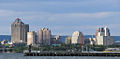
New Haven
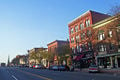
Middletown's historic Main Street


External links
All links retrieved March 2, 2017.
- State of Connecticut - Official state website
- Directory of Web sites of Connecticut towns and cities
- CTVisit.com - Official state tourism website
- www.ctgenealogy.com Connecticut Society of Genealogists (Est. 1968)
- Connecticut Historical Society
- Connecticut Business & Industry Association
| Political divisions of the United States | |||||||
|---|---|---|---|---|---|---|---|
| |||||||
Credits
New World Encyclopedia writers and editors rewrote and completed the Wikipedia article in accordance with New World Encyclopedia standards. This article abides by terms of the Creative Commons CC-by-sa 3.0 License (CC-by-sa), which may be used and disseminated with proper attribution. Credit is due under the terms of this license that can reference both the New World Encyclopedia contributors and the selfless volunteer contributors of the Wikimedia Foundation. To cite this article click here for a list of acceptable citing formats.The history of earlier contributions by wikipedians is accessible to researchers here:
The history of this article since it was imported to New World Encyclopedia:
Note: Some restrictions may apply to use of individual images which are separately licensed.