Baghdad
| Baghdad بغداد |
|
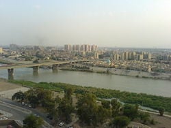
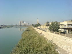
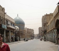
| General view of the north-western part of Baghdad city across the Tigris, 2006. | |
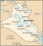
| The location of Baghdad within Iraq. | |
| Coordinates: {{#invoke:Coordinates|coord}}{{#coordinates:33|20|00|N|44|26|00|E|type:city | |
|---|---|
| name= }} | |
| Country | Iraq |
| Province | Baghdad Governorate |
| Government | |
| - Governor | Hussein Al Tahhan |
| Area | |
| - City | 734 km² (283.4 sq mi) |
| Elevation | 34 m (112 ft) |
| Population (2006)[1][2] | |
| - City | 7.0 million |
| - Density | 34,280/km² (88,784.8/sq mi) |
| - Metro | 9.0 million |
| Approximate figures | |
| Time zone | GMT +3 (UTC) |
| - Summer (DST) | +4 (UTC) |
Baghdad (Arabic: بغداد Baġdād) is the capital of Iraq and of Baghdad Governorate, which it is also coterminous with. With a municipal population estimated at 7,000,000, it is the largest city in Iraq, and the second-largest city in the Arab World (after Cairo).
Located on the Tigris River, the city dates back to at least the 8th century C.E., and probably to pre-Islamic times. Once the center of Dar al-salam, the Muslim world, Baghdad has been a center of violent conflict since 2003 because of the ongoing Iraq War.
Geography
The most reliable and most widely accepted view of the etymology of the name "Baghdad" is that it is a Middle Persian compound of Bag "god" + dād "given", translating to "god-given" or "God's gift", whence Modern Persian Baɣdād. The name is pre-Islamic and the origins are unclear. The city was formerly known as “Madinat as-Salam”, or “City of Peace”.
The city is located on a vast alluvial plain, 112 feet (34 metres) above sea level, bisected by the Tigris River.
The Tigris splits Baghdad in half, with the Eastern half being called 'Risafa' and the Western half known as 'Karkh'. The land on which the city is built is almost entirely flat and low-lying, being of alluvial origin due to the periodic large floods which have occurred on the river.
Baghdad has a hot arid climate and is one of the hottest cities in the world. In the summer from June to August, the average maximum temperature is as high as 111°F (44°C) accompanied by blazing sunshine: rainfall is almost completely unknown at this time of year. Though the humidity is very low (usually under 10 percent) due to Baghdad's distance from the marshy Persian Gulf, dust storms from the deserts to the west are a normal occurrence during the summer. In the winter, from December to February, by contrast, Baghdad has maximum temperatures averaging 59°F to 61°F (15°C to 16°C). The average January minimum is around 39°F (4°C) but temperatures below 32°F (0°C) are not uncommon during this season.
Annual rainfall, almost entirely confined to the period from November to March, averages around 5.5 inches (140mm) but has been as high as 23 inches (575mme) and as low as less than one inch (23mm). On January 11, 2008, light snow fell across Baghdad for the first time in memory.
Size – land area, size comparison
The city was subject to occasional floods, until 1956, when a dam on the Tigris at Sāmarrāʾ to the north was completed.
Districts
History
Foundation
Located in the cradle of civilisations area between the Tigris and Euphrates rivers, and although a city of Baghdad is mentioned in pre-Islamic texts, including the Talmud, the city of Baghdad dates from 764 C.E., when the Abbasid caliph Abu Ja'far Al-Mansur founded the city.
Mansur believed that Baghdad was the perfect city to be the capital of the Islamic empire under the Abbasids. The site of the more ancient city of Babylon, deserted since the second century B.C.E., is located about 55 miles (85 kilometers) to the south. Baghdad's location was on a trade route for the Khurasans where caravans met and traded. The area had abundant water and a healthy climate. The goal was to replace Harran as the seat of the caliphal government.
The city was designed as a circle about 2km in diameter, leading it to be known as the "Round City". The original design shows a ring of residential and commercial structures along the inside of the city walls, but the final construction added another ring, inside the first. In the center of the city lay the mosque, as well as headquarters for guards. The purpose or use of the remaining space in the center is unknown. The circular design of the city was a direct reflection of the traditional Persian Sasanian urban design. The ancient Sasanian city of Gur/Firouzabad is nearly identical in its general circular design, radiating avenues, and the government buildings and temples at the center of the city.
Center of learning
Baghdad came into its prime about 800 C.E., during the reign of the caliph Harun al-Rashid, when the streets were paved with a tar substance. Baghdad became a hub of learning and commerce. The House of Wisdom was an establishment dedicated to the translation of Greek, Middle Persian and Syriac works. The Barmakids were influential in bringing scholars from the nearby Academy of Gundishapur, facilitating the introduction of Greek and Indian science into the Arabic world. Baghdad was likely the largest city in the world from shortly after its foundation until the 930s, when it was tied by Córdoba. Several estimates suggest that the city contained over a million inhabitants at its peak. A portion of the population of Baghdad originated in Iran, especially from Khorasan. Many of Scheherazade's tales in One Thousand and One Nights are set in Baghdad during this period.
Invasions
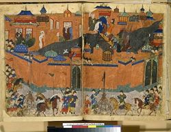
By the 10th century, the city's population was between 300,000 and 500,000. Baghdad's early meteoric growth slowed due to troubles within the Caliphate, including relocations of the capital to Samarra (during 808–819 and 836–892), the loss of the western and easternmost provinces, and periods of political domination by the Iranian Buwayhids (945–1055) and Seljuk Turks (1055–1135). Nevertheless, the city remained one of the cultural and commercial hubs of the Islamic world until February 10 1258, when it was sacked by the Mongols under Hulagu Khan during the sack of Baghdad. The Mongols massacred most of the city's inhabitants, including the Abbasid Caliph Al-Musta'sim, and destroyed large sections of the city. The canals and dykes forming the city's irrigation system were also destroyed. The sack of Baghdad put an end to the Abbasid Caliphate, a blow from which the Islamic civilization never fully recovered.
At this point Baghdad was ruled by the Il-Khanids, the Mongol emperors of Iran. In 1401, Baghdad was again sacked, by Timur ("Tamerlane"). It became a provincial capital controlled by the Jalayirid (1400–1411), Qara Quyunlu (1411–1469), Aq Quyunlu (1469–1508), and Safavid (1508–1534) dynasties.
Ottoman rule
In 1534, Baghdad was conquered by the Ottoman Turks. Under the Ottomans, Baghdad fell into a period of decline, partially as a result of the enmity between its rulers and Persia. For a time, Baghdad had been the largest city in the Middle East before being overtaken by Constantinople in the 16th century. The city saw relative revival in the latter part of the 18th century under the Mamluk rule. The Nuttall Encyclopedia reports the 1907 population of Baghdad as 185,000.
World wars
The British drove the Ottomans from much of the area during World War I (1914-1918). The British mandate of Mesopotamia was formed out of three former Ottoman vilayets (regions): Mosul, Baghdad, and Basra, which the Ottomans ruled from Baghdad. Hashemite king, Faisal I, who had been forced out of Syria by the French, was selected to be client ruler for the British, while government officials were selected from the Sunni Arab elite in the region.
Iraq was given formal independence in 1932, but the United Kingdom invaded Iraq in 1941 for fear that the government of Rashid Ali might cut oil supplies to Western nations, and because of strong idealogical leanings to Nazi Germany. A military occupation followed the restoration of the Hashemite monarchy, and the occupation ended on October 26, 1947.
Coups
In 1958, the Iraqi Army overthrew the reinstated Hashemite monarchy in a coup known as the July 14 Revolution, and brought Brigadier General Abdul Karim Qassim to power. Baghdad's population grew from an estimated 145,000 in 1900 to 580,000 in 1950 of which 140,000 were Jewish. In 1968, the Arab Socialist Ba’ath Party, under the leadership of General Ahmed Hassan al-Bakr, seized power. The Ba’ath Party gradually came under the control of Saddam Hussein al-Majid al Tikriti, who acceded to the presidency and control of the Revolutionary Command Council, then Iraq's supreme executive body, in July 1979, while killing off many of his opponents. During the 1970s Baghdad experienced a period of prosperity and growth because of a sharp increase in the price of petroleum, Iraq's main export. New infrastructure including modern sewage, water, and highway facilities were built during this period.
War
However, the Iran-Iraq War of the 1980s was a difficult time for the city, as money flowed into the army and thousands of residents were killed. Iran launched a number of missile attacks against Baghdad, although they caused relatively little damage and few casualties. In 1991 the Gulf War caused damage to Baghdad's transportation, power, and sanitary infrastructure.
US invasion
Baghdad was bombed very heavily in March and April 2003 and fell under United States control by April 7-April 9. Additional damage was caused by the severe looting during the days following the end of the war. With the deposition of Saddam Hussein's regime, the city was occupied by U.S. troops. The Coalition Provisional Authority established a three-square-mile (8km²) "Green Zone" within the heart of the city from which it governed Iraq during the period before the new Iraqi government was established. The Coalition Provisional Authority ceded power to the interim government at the end of June 2004 and thereafter dissolved itself.[3]
Residents of Baghdad became impatient with the United States because essential services like electricity were still unreliable more than a year after the invasion. In the hot summer of 2004, electricity was only available intermittently in most areas of the city. The lack of security was another pressing concern. The curfew imposed immediately after the invasion was lifted in the winter of 2003, but the city with a once-vibrant night life was still considered too dangerous after dark for many citizens. Those dangers included kidnapping and the risk of being caught in fighting between security forces and insurgents.
On April 10, 2007, the United States military began construction of a three mile (5km) long, 3.5 metre tall wall around the Sunni district of Baghdad. On April 23, the Iraqi Prime Minister, Nouri Maliki, called for construction to be halted on the wall.
The on-going sectarian violence had, by the beginning of summer 2007, cantoned the city of Baghdad into distinct and hostile zones: a larger Shia city (nearly all of the city east of the Tigris, with the exception of Adhamiya and the Rashid districts), and a smaller Sunni city, west of the Tigris (with the exception of Kadhimiya and southwestern districts).
Reconstruction
Most Iraqi reconstruction efforts have been devoted to the restoration and repair of badly damaged urban infrastructure. More visible efforts at reconstruction through private development, like architect and urban designer Hisham N. Ashkouri's Baghdad Renaissance Plan and Sindbad Hotel Complex and Conference Center, garnered early interest but remain undeveloped due to the instability of the region.
Government
The politics of post-invasion Iraq takes place in a framework of a more or less federal parliamentary representative democratic republic, whereby the prime minister is the head of government, and of a pluriform multi-party system. The City of Baghdad has 89 official neighborhoods within nine districts. Before 2003, these served as administrative centers for the delivery of municipal services. Beginning in April 2003, the U.S. controlled Coalition Provisional Authority (CPA) began creating neighborhood councils, elected by neighborhood caucuses. Each neighborhood council elected representatives to serve on one of the city's nine district councils. The nine district councils elect representatives to serve on the 37-member Baghdad City Council.
The same process was used to provide representative councils for the other communities in Baghdad Province. There, local councils were elected from 20 neighborhoods (Nahia) and these councils elected representatives from their members to serve on six district councils (Qada). As within the City, the district councils then elected representatives from among their members to serve on the 35-member Baghdad Regional Council.
The final step in the establishment of the system of local government for Baghdad Province was the election of the Baghdad Provincial Council. As before, the representatives to the Provincial Council were elected by their peers from the lower councils in numbers proportional to the population of the districts they represent. The 41 member Provincial Council took office in February, 2004, and served until National elections held in January 2005, when a new Provincial Council was elected.
This system of 127 separate councils may seem overly cumbersome but Baghdad Province is home to approximately seven million people. At the lowest level, the neighborhood councils, each council represents an average of 74,000 people.
Economy
Baghdad has for centuries been the richest and economically most important city of Iraq. The city's location on the river Tigris, at the point where land and river transportation meet, means it is the main transportation hub of Iraq, and is linked with Jordan and Syria with excellent highways.
Per capita GDP, rank
Baghdad is the centre of financial operations and the headquarters of the Central Bank of Iraq. Most of the national bureaucracy is located here, and the state is the principal employer.
Tourism
Baghdad has oil refineries, food-processing factories, tanneries, and textile mills. Baghdad's industries produce leather goods, furniture, wood products, chemicals, electrical equipment, textiles, clothing, bricks, cement, tobacco, processed food and beverages, as well as handicrafts, like cloth, household utensils, jewellery, leather, felt and rugs.
Transport: Road, rail, air, sea
Despite sectarian violence and political chaos, by the end of 2006 there were signs that many sectors of Iraq's economy were growing, Newsweek International reported, in December 2006, that real estate, construction and retail sales industries were booming, the number of registered companies in Iraq grew from 8000 in 2003 to 34,000 in 2006, and Iraq earned $41 billion in oil revenue that year.
Demographics
Population, population rank Race/ethnicity - historical background of ethnic groups
The dialect of Arabic spoken in Baghdad today differs from that of other large urban centers in Iraq, having features more characteristic of nomadic Arabic dialects (Verseegh, The Arabic Language). It is possible that this was caused by the repopulating of the city with rural residents after the multiple sacks of the late Middle Ages.
In 1950, 90 percent of the Baghdad's population were Sunnis Muslims. Now Shi'ite Muslims make up 40 percent of Baghdad's population and most of the rest are Sunni. A sizeable Christian community also has a presence in Baghdad.
Education in Iraq is free on all levels. Baghdad has the University of Baghdad, al-Mustansiriyya University, and the University of Technology. There are more than 1000 primary schools in the governorate, hundreds of intermediate and secondary schools, several vocational schools, and technical institutes. Institutions offering cultural education there include the Academy of Music, Institute of Fine Arts and the Music and Ballet School.
Baghdad is also home to a number of museums which housed artifacts and relics of ancient civilizations; many of these were stolen, and the museums looted, during the widespread chaos immediately after U.S. forces entered the city.
Culture
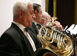

Baghdad has always played an important role in Arab cultural life and has been the home of noted writers, musicians and visual artists.
Institutions
Some of the important cultural institutions in the city include:
- Iraqi National Orchestra – Rehearsals and performances were briefly interrupted during the second Gulf War, but have since returned to normal.
- National Theatre of Iraq – The theatre was looted during the 2003 Invasion of Iraq, but efforts are underway to restore the theatre.[4]
The live theatre scene received a boost during the 1990s when UN sanctions limited the import of foreign films. As many as 30 movie theatres were reported to have been converted to live stages, producing a wide range of comedies and dramatic productions.[5]
During the 2003 occupation of Iraq, AFN Iraq ("Freedom Radio") broadcast news and entertainment within Baghdad, among other locations. There is also a private radio station called "Dijlah" (named after the Arabic word for the Tigris River) that was created in 2004 as Iraq's first independent talk radio station. Radio Dijlah offices, in the Jamia neighborhood of Baghdad, have been attacked on several occasions.
Sights and monuments
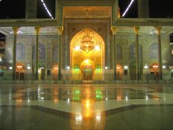
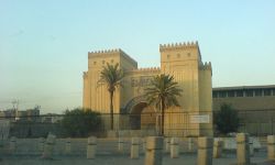
Points of interest include the National Museum of Iraq whose priceless collection of artifacts was looted during the 2003 invasion, and the iconic Hands of Victory arches. Multiple Iraqi parties are in discussions as to whether the arches should remain as historical monuments or be dismantled. Thousands of ancient manuscripts in the National Library were destroyed when the building burnt down during the 2003 invasion of Iraq. The Al Kadhimain Shrine in the northwest of Baghdad (in Kadhimiya) is one of the most important Shi'ite religious sites in Iraq. It was finished in 1515 and the 7th (Musa ibn Jafar al-Kathim) and the 9th Imams (Mohammad al-Jawad) were buried there. One of the oldest buildings is the 12th century or 13th century Abbasid Palace. The palace is part of the central historical area of the city and close to other historically important buildings such as the Saray Building and Al-Mustansiriyah School (From the Abbasid Period). There are other landmarks in Baghdad, each of which marks a certain historical era:
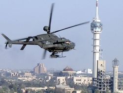
- Baghdad Tower (used to be known as Saddam Tower): before its partial destruction due to the USA bombing of the Ma'amoon Telecommunication Center next to it, the tower used to be the highest point in the city and from where all Baghdad can be seen. The construction of the tower marks a period of the post-Gulf-war of 1991 reconstruction efforts.
- The Two Level Bridge in Jadriyah (Jisr Abul Tabqain). Even though planing for this bridge began before Saddam's take over, the bridge was never built. As part of recent reconstruction efforts, the long planned bridge was built. It connects Al-Doura area with the rest of the Baghdad and complements the 14th of July Bridge.
- Sahat Al Tahrir (Liberation Square) downtown Baghdad.
- Saray souq
- Baghdadi Museum (wax museum)
- Mustansiriya School, a 13th century Abbasid structure
- National Museum of Iraq
- Al-Zawra'a Park in Al-Mansour Area and almost in a central location of Baghdad.
- Kahramana and the 40 Thieves Square.
- Al Jundi Al Majhool Monument (The unknown soldier).
- Al Shaheed Monument. Monument to the Iraqi soldiers killed in the Iran-Iraq war, located on the east bank of the Tigris.
- A wide road built under Saddam as a parade route, and across it is the Hands of Victory, which is a pair of enormous crossed swords cast from weapons of soldiers who died in the Iran-Iraq War under Saddam's command.
Baghdad Zoo
The Baghdad Zoo was the largest zoo in the Middle East. Within eight days following the 2003 invasion, however, only 35 of the 650 to 700 animals in the facility survived. This was a result of bombing, theft of some animals for human food, and starvation of caged animals that had no food or water. Survivors included larger animals like bears, lions, and tigers. Notwithstanding the chaos brought by the invasion, South African Lawrence Anthony and some of the zoo keepers cared for the animals and fed the carnivores donkeys they had bought locally.
Sport
Baghdad is home to some of the most successful football teams in Iraq, the biggest being Al Quwa Al Jawiya (Airforce club), Al Zawra, Al Shurta (Police) and Al Talaba (Students). The largest stadium in Baghdad is Al Shaab Stadium which was opened in 1966. Another. Much larger stadium, are still in the opening stages of construction.
The city has also had a strong tradition of horse racing ever since World War I, known to Baghdadis simply as 'Races'. There are reports of pressures by the Islamists to stop this tradition due to the associated gambling.[citation needed]
Baghdad's major neighborhoods
- Adhamiyah
- Al-Kadhimya
- Al-Ghazaliya
- Al-A'amiriya
- Dora
- Karrada
- Al-Jadriya Area
- Al-Mansour
- Zayouna
- Sadr City
- Al-Saydiya
- Hurriya City
- Baghdad Al-Jadida(New Baghdad)
- Al Baladeyat - Tisaa Nisan (9th of April)
- Al-Sa'adoon area
- Al-Shu'ala
- Bab Al-Moatham
- Bab Al-Sharqi
- Al-Baya'
- Al-Za'franiya
- Hayy Ur
- Sha'ab
- Hayy Al-Jami'a
- Al-Adel
- Al:Khadhraa
- Hayy Al-Jihad
- Hayy Al-A'amel
- Hayy Al-Mansor
- Hayy Aoor
- Al-Horaya
- Hayy Al-Shurtta
- Yarmouk
- Al-Saydiya
- Jesr Diyala
- Abu Disher
- Raghiba Khatoun
- Arab Jijur
- Al-Awashosh
- Al-Fathel
- hoor Rajab
- Al-Ubedy
- Hifah Street
- Al-Wazireya
Baghdad's major streets
Source: stripes.com
- Haifa Street
- Hilla Road — Runs from the South into Baghdad via Yarmouk (Baghdad)
- Caliphs Street — site of historical mosques and churches.
- Sadoun Street — stretching from Liberation Square to Masbah
- Mohammed Al-Qassim highway near Adhamiyah
- Abu Nuwas Street — runs along the Tigris from the from Jumhouriya Bridge to the 14 July Suspended Bridge
- Damascus Street — goes from Damascus Square to the International Airport Road
- Mutanabbi Street — A street with numerous bookshops, named after the 10th century Iraqi poet Al-Mutanaby
- Rabia Street
- Arbataash Tamuz (14th July) Street (Mosul Road)
- Muthana al-Shaibani Street
- Bor Saeed (Port Said) Street
- Thawra Street
- Al Qanat Street — runs through Baghdad north-south
- Al Khat al Sare'a - Mohammed al Qasim (High Speed lane) - runs through bagdhad, north -south
- Al Sinaa Street (Industry St.) runs by the University of Technology - center of computers trade in Baghdad.
- Al Nidhal Street
- Al Rasheed Street — Downtown Baghdad
- Al Jamhuriah Street — Downtown Baghdad
- Falastin (Palestine) Street
- Tariq el Muaskar — (Al Rasheed Camp Road)
- Matar Baghdad Al-Dawli (Airport Road)
See also
- Reconstruction of Iraq
- List of places in Iraq
- Firdus Square
- Baghdad City Hall
- Baghdad Arabic
- Baghdad Airport Road
- Baghdad bridge stampede
- Baghdad Security Plan
ReferencesISBN links support NWE through referral fees
- ↑ Estimates of total population differ substantially. The Encyclopædia Britannica gives a 2001 population of 4,950,000, the 2006 Lancet Report states a population of 6,554,126 in 2004.
- "Baghdad." Encyclopædia Britannica. 2006. Encyclopædia Britannica Online. 13 November, 2006.
 PDF. By Gilbert Burnham, Riyadh Lafta, Shannon Doocy, and Les Roberts. The Lancet, October 11, 2006
- Baghdad from GlobalSecurity.org
- ↑ "Cities and urban areas in Iraq with population over 100,000", Mongabay.com
- ↑ Rajiv Chandrasekaran, in his book "Imperial Life in the Emerald City: Inside Iraq's Green Zone (Vintage Books 2006), cites the day as June 28, 2004, at 10:00 AM, with Viceroy Bremer declaring a dissolution and presenting documents to that affect to Prime Minster Ayad Allawi two days before the announced date of June 30th. (p.329)
- ↑ Five women confront a new Iraq | csmonitor.com
- ↑ In Baghdad, Art Thrives As War Hovers
- “Yakut: Baghdad under the Abbasids, c. 1000C.E.”. Davis Press. Ed. By Paul Halsall, July 1998.
Further reading
- By Desert Ways to Baghdad, by Louisa Jebb (Mrs. Roland Wilkins), 1908 (1909 ed) (a searchable facsimile at the University of Georgia Libraries; DjVu &
 PDF format)
 - A Dweller in Mesopotamia, being the adventures of an official artist in the garden of Eden, by Donald Maxwell, 1921 (a searchable facsimile at the University of Georgia Libraries; DjVu &
 PDF format)
External links
-
- Mapping from Multimap or GlobalGuide or Google Maps
- Satellite image from WikiMapia
- Mapping from OpenStreetMap
- Map of Baghdad
- Interactive map
- Iraq - Urban Society
- Envisioning Reconstruction In Iraq
- Description of the original layout of Baghdad
- Ethnic and sectarian map of Baghdad - Healingiraq
- Baghdad Renaissance Plan
- UAE Investors Keen On Taking Part In Baghdad Renaissance Project
- Man With A Plan: Hisham Ashkouri
- Renaissance Plan In The News
- ARCADD, Inc.
- Kabul, City of Light Development
- Kabul - City of Light, 9 Billion dollar modern urban development project
- Sindbad Hotel Complex and Conference Center
- Song - Birds Over Baghdad
- Baghdad Treasure
- Baghdad Burning Riverbend
- Electronic Iraq
- Baghdad economy starting to boom New York Post, retrieved July 21, 2008.
- Baghdad Looklex Encyclopaedia, retrieved July 21, 2008.
Credits
New World Encyclopedia writers and editors rewrote and completed the Wikipedia article in accordance with New World Encyclopedia standards. This article abides by terms of the Creative Commons CC-by-sa 3.0 License (CC-by-sa), which may be used and disseminated with proper attribution. Credit is due under the terms of this license that can reference both the New World Encyclopedia contributors and the selfless volunteer contributors of the Wikimedia Foundation. To cite this article click here for a list of acceptable citing formats.The history of earlier contributions by wikipedians is accessible to researchers here:
The history of this article since it was imported to New World Encyclopedia:
Note: Some restrictions may apply to use of individual images which are separately licensed.
