Difference between revisions of "Kentucky" - New World Encyclopedia
Vicki Phelps (talk | contribs) (Imported credit version) |
Vicki Phelps (talk | contribs) |
||
| Line 1: | Line 1: | ||
| − | |||
| − | |||
{{US state| | {{US state| | ||
Name = Kentucky | | Name = Kentucky | | ||
| Line 66: | Line 64: | ||
==Geography== | ==Geography== | ||
| − | |||
[[Image:Map of Kentucky NA.png|thumb|right|Kentucky]] | [[Image:Map of Kentucky NA.png|thumb|right|Kentucky]] | ||
[[Image:KYphysiography.jpg|thumb|right|Kentucky's regions (click on image for color coding information.)]] | [[Image:KYphysiography.jpg|thumb|right|Kentucky's regions (click on image for color coding information.)]] | ||
| Line 75: | Line 72: | ||
Kentucky can be divided into five primary regions: the [[Cumberland Plateau]] in the east, the north-central [[Bluegrass region]], the south-central and western [[Pennyroyal Plateau]], the [[Western Coal Fields]] and the far-west [[Jackson Purchase]]. The Bluegrass region is commonly divided into two regions, the Inner Bluegrass — the encircling 90 miles (145 km) around [[Lexington, Kentucky|Lexington]] — and the Outer Bluegrass, the region that contains most of the Northern portion of the state, above the [[Knobs region|Knobs]]. Much of the outer Bluegrass is in the [[Eden Shale Hills]] area, made up of short, steep, and very narrow hills. | Kentucky can be divided into five primary regions: the [[Cumberland Plateau]] in the east, the north-central [[Bluegrass region]], the south-central and western [[Pennyroyal Plateau]], the [[Western Coal Fields]] and the far-west [[Jackson Purchase]]. The Bluegrass region is commonly divided into two regions, the Inner Bluegrass — the encircling 90 miles (145 km) around [[Lexington, Kentucky|Lexington]] — and the Outer Bluegrass, the region that contains most of the Northern portion of the state, above the [[Knobs region|Knobs]]. Much of the outer Bluegrass is in the [[Eden Shale Hills]] area, made up of short, steep, and very narrow hills. | ||
| − | |||
| − | |||
| − | |||
| − | |||
| − | |||
| − | |||
| − | |||
| − | |||
| − | |||
| − | |||
===Climate=== | ===Climate=== | ||
| Line 105: | Line 92: | ||
|- | |- | ||
|[[2008 Super Tuesday tornado outbreak]] || 7 | |[[2008 Super Tuesday tornado outbreak]] || 7 | ||
| − | |||
| − | |||
| − | |||
| − | |||
| − | |||
| − | |||
| − | |||
| − | |||
| − | |||
| − | |||
| − | |||
| − | |||
| − | |||
| − | |||
| − | |||
| − | |||
| − | |||
| − | |||
| − | |||
| − | |||
| − | |||
| − | |||
| − | |||
| − | |||
| − | |||
| − | |||
| − | |||
| − | |||
| − | |||
| − | |||
| − | |||
| − | |||
| − | |||
| − | |||
| − | |||
| − | |||
| − | |||
| − | |||
| − | |||
| − | |||
| − | |||
| − | |||
| − | |||
| − | |||
| − | |||
| − | |||
| − | |||
| − | |||
| − | |||
| − | |||
| − | |||
| − | |||
| − | |||
| − | |||
| − | |||
| − | |||
| − | |||
| − | |||
| − | |||
| − | |||
| − | |||
| − | |||
| − | |||
| − | |||
| − | |||
| − | |||
| − | |||
| − | |||
| − | |||
| − | |||
| − | |||
| − | |||
| − | |||
| − | |||
| − | |||
| − | |||
| − | |||
| − | |||
| − | |||
| − | |||
| − | |||
| − | |||
| − | |||
| − | |||
| − | |||
| − | |||
| − | |||
| − | |||
| − | |||
| − | |||
| − | |||
| − | |||
| − | |||
| − | |||
| − | |||
| − | |||
| − | |||
|} | |} | ||
===Lakes and rivers=== | ===Lakes and rivers=== | ||
[[Image:Picture 491.jpg|thumb|right|[[Lake Cumberland]] is the largest artificial lake, in terms of volume, east of the [[Mississippi River]].]] | [[Image:Picture 491.jpg|thumb|right|[[Lake Cumberland]] is the largest artificial lake, in terms of volume, east of the [[Mississippi River]].]] | ||
| − | Kentucky’s | + | Kentucky’s 90000 miles of streams provides one of the most expansive and complex stream systems in the nation. Kentucky has both the largest artificial lake east of the Mississippi in water volume ([[Lake Cumberland]]) and surface area ([[Kentucky Lake]]). It is the only [[U.S. state]] to be bordered on three sides by rivers — the [[Mississippi River]] to the west, the [[Ohio River]] to the north, and the [[Big Sandy River (Ohio River)|Big Sandy River]] and [[Tug Fork]] to the east.<ref name=kye-rivers>{{cite book |editor=Kleber, John E. |others=Associate editors: [[Thomas D. Clark]], Lowell H. Harrison, and James C. Klotter |title=''The Kentucky Encyclopedia'' |year=1992 |publisher=The University Press of Kentucky |location=[[Lexington, Kentucky]] |isbn=0813117720 |chapter=Rivers}}</ref> Its major internal rivers include the [[Kentucky River]], [[Tennessee River]], [[Cumberland River]], [[Green River (Kentucky)|Green River]], and [[Licking River (Kentucky)|Licking River]]. |
Though it has only three major natural lakes,<ref name=kye>{{cite book |editor=Kleber, John E. |others=Associate editors: [[Thomas D. Clark]], Lowell H. Harrison, and James C. Klotter |title=''The Kentucky Encyclopedia'' |year=1992 |publisher=The University Press of Kentucky |location=[[Lexington, Kentucky]] |isbn=0813117720 |chapter=Lakes}}</ref> the state is home to many [[artificial lake]]s. Kentucky also has more navigable miles of water than any other state in the union, other than [[Alaska]].<ref>{{cite web | title=Corbin, Kentucky: A Fisherman's Paradise | publisher=Corbin, Kentucky Economic Development | url=http://www.corbinkentucky.us/fishing.htm | accessdate=2006-11-29 }}</ref> | Though it has only three major natural lakes,<ref name=kye>{{cite book |editor=Kleber, John E. |others=Associate editors: [[Thomas D. Clark]], Lowell H. Harrison, and James C. Klotter |title=''The Kentucky Encyclopedia'' |year=1992 |publisher=The University Press of Kentucky |location=[[Lexington, Kentucky]] |isbn=0813117720 |chapter=Lakes}}</ref> the state is home to many [[artificial lake]]s. Kentucky also has more navigable miles of water than any other state in the union, other than [[Alaska]].<ref>{{cite web | title=Corbin, Kentucky: A Fisherman's Paradise | publisher=Corbin, Kentucky Economic Development | url=http://www.corbinkentucky.us/fishing.htm | accessdate=2006-11-29 }}</ref> | ||
| Line 212: | Line 102: | ||
===Natural environment and conservation=== | ===Natural environment and conservation=== | ||
Kentucky has an expansive park system which includes one national park, two National Recreation areas, two National Historic Parks, two national forests, 45 state parks, {{convert|37696|acre|km2|0}} of state forest, and 82 Wildlife Management Areas. | Kentucky has an expansive park system which includes one national park, two National Recreation areas, two National Historic Parks, two national forests, 45 state parks, {{convert|37696|acre|km2|0}} of state forest, and 82 Wildlife Management Areas. | ||
| − | |||
| − | |||
| − | |||
| − | |||
| − | |||
| − | |||
| − | |||
| − | |||
| − | |||
| − | |||
| − | |||
| − | |||
| − | |||
| − | |||
| − | |||
| − | |||
| − | |||
| − | |||
| − | |||
| − | |||
| − | |||
| − | |||
| − | |||
| − | |||
| − | |||
| − | |||
| − | |||
| − | |||
| − | |||
| − | |||
| − | |||
| − | |||
| − | |||
| − | |||
| − | |||
| − | |||
| − | |||
| − | |||
| − | |||
| − | |||
| − | |||
| − | |||
| − | |||
| − | |||
| − | |||
| − | |||
| − | |||
| − | |||
| − | |||
| − | |||
| − | |||
| − | |||
| − | |||
| − | |||
| − | |||
| − | |||
| − | |||
===Significant natural attractions=== | ===Significant natural attractions=== | ||
| Line 314: | Line 147: | ||
[[Image:Boone Cumberland.jpg|thumb|right|''[[Daniel Boone]] Escorting Settlers through the [[Cumberland Gap]]'' ([[George Caleb Bingham]], oil on canvas, 1851–52).]] | [[Image:Boone Cumberland.jpg|thumb|right|''[[Daniel Boone]] Escorting Settlers through the [[Cumberland Gap]]'' ([[George Caleb Bingham]], oil on canvas, 1851–52).]] | ||
[[Image:Lincoln and Davis Statue.jpg|thumb|right|Both Abraham Lincoln and [[Jefferson Davis]] were born in Kentucky.]] | [[Image:Lincoln and Davis Statue.jpg|thumb|right|Both Abraham Lincoln and [[Jefferson Davis]] were born in Kentucky.]] | ||
| − | |||
| − | |||
| − | |||
Although inhabited by [[Native Americans in the United States|Native Americans]] in prehistoric times, when explorers and settlers began entering Kentucky in the mid-1700s, there were no major Native American settlements in the region.<ref>{{cite web |url=http://www.merceronline.com/Native/native01.htm |title=The Presence |publisher=Mercer County Online |accessdate=2006-11-29 |work=History of Native Americans in Central Kentucky }}</ref> Instead, the country was used as hunting grounds by [[Shawnee]]s from the north and [[Cherokee]]s from the south. Much of what is now Kentucky was purchased from Native Americans in the treaties of [[Treaty of Fort Stanwix|Fort Stanwix]] (1768) and [[Treaty of Sycamore Shoals|Sycamore Shoals]] (1775).<ref>{{cite web |url=http://web-books.com/Classics/Nonfiction/History/Southwest2/Southwest2C7P1.htm |title=The Dark and Bloody Hunting Ground |accessdate=2006-11-29 |last=Skinner |first=Constance |work=Pioneers of the Old Southwest |publisher=WebBooks.com}}</ref> Thereafter, Kentucky grew rapidly as the first settlements west of the [[Appalachian Mountains]] were founded, with settlers (primarily from [[Virginia]], [[North Carolina]], [[Maryland]], [[Delaware]], and [[Pennsylvania]]) entering the region either over land via [[Braddock Road (Braddock expedition)|Braddock Road]] and the [[Cumberland Gap]], or by water down the [[Ohio River]] from points upstream, or up the Ohio River from the Mississippi. The first part to be settled was the northern part, along the Ohio River, with [[Lexington, Kentucky|Lexington]] and [[Washington, Kentucky|Washington]] being the first major settlements. A detailed account of this can be read in the memoirs of [[Spencer Records]]. Next, the southern part of the state was settled, via the [[Wilderness Trail]], which went along the [[Great Appalachian Valley]] and across the [[Cumberland Gap]], blazed by [[Daniel Boone]], traditionally considered one of the founders of the state.<ref>>{{cite web | title=Book Description for ''The Life of Daniel Boone: The Founder of the State of Kentucky and Colonel's Boone Autobiography''| publisher=Amazon.com | url=http://www.amazon.com/Life-Daniel-Boone-Kentucky-Autobiography/dp/1589639901 | accessdate=2006-11-29}}</ref> [[Shawnee]]s north of the Ohio River, however, were unhappy about the settlement of Kentucky, and allied themselves with the [[Great Britain|British]] in the [[American Revolutionary War]] (1775–1783).<ref>{{cite web |url=http://www.polsci.wvu.edu/wv/Monongalia/monhistory.html |title=Monongalia County History |accessdate=2006-11-29 |last=Dilger |first=Dr. Robert Jay |publisher=West Virginia University }}</ref> Kentucky was a battleground during the war; the [[Battle of Blue Licks]], one of the last major battles of the Revolution, was fought in Kentucky.<ref>{{cite web | title=The Battle of Blue Licks | publisher=EarlyAmerica.com| url=http://www.earlyamerica.com/review/winter2000/bluelick.html | accessdate=2006-11-29 }}</ref> | Although inhabited by [[Native Americans in the United States|Native Americans]] in prehistoric times, when explorers and settlers began entering Kentucky in the mid-1700s, there were no major Native American settlements in the region.<ref>{{cite web |url=http://www.merceronline.com/Native/native01.htm |title=The Presence |publisher=Mercer County Online |accessdate=2006-11-29 |work=History of Native Americans in Central Kentucky }}</ref> Instead, the country was used as hunting grounds by [[Shawnee]]s from the north and [[Cherokee]]s from the south. Much of what is now Kentucky was purchased from Native Americans in the treaties of [[Treaty of Fort Stanwix|Fort Stanwix]] (1768) and [[Treaty of Sycamore Shoals|Sycamore Shoals]] (1775).<ref>{{cite web |url=http://web-books.com/Classics/Nonfiction/History/Southwest2/Southwest2C7P1.htm |title=The Dark and Bloody Hunting Ground |accessdate=2006-11-29 |last=Skinner |first=Constance |work=Pioneers of the Old Southwest |publisher=WebBooks.com}}</ref> Thereafter, Kentucky grew rapidly as the first settlements west of the [[Appalachian Mountains]] were founded, with settlers (primarily from [[Virginia]], [[North Carolina]], [[Maryland]], [[Delaware]], and [[Pennsylvania]]) entering the region either over land via [[Braddock Road (Braddock expedition)|Braddock Road]] and the [[Cumberland Gap]], or by water down the [[Ohio River]] from points upstream, or up the Ohio River from the Mississippi. The first part to be settled was the northern part, along the Ohio River, with [[Lexington, Kentucky|Lexington]] and [[Washington, Kentucky|Washington]] being the first major settlements. A detailed account of this can be read in the memoirs of [[Spencer Records]]. Next, the southern part of the state was settled, via the [[Wilderness Trail]], which went along the [[Great Appalachian Valley]] and across the [[Cumberland Gap]], blazed by [[Daniel Boone]], traditionally considered one of the founders of the state.<ref>>{{cite web | title=Book Description for ''The Life of Daniel Boone: The Founder of the State of Kentucky and Colonel's Boone Autobiography''| publisher=Amazon.com | url=http://www.amazon.com/Life-Daniel-Boone-Kentucky-Autobiography/dp/1589639901 | accessdate=2006-11-29}}</ref> [[Shawnee]]s north of the Ohio River, however, were unhappy about the settlement of Kentucky, and allied themselves with the [[Great Britain|British]] in the [[American Revolutionary War]] (1775–1783).<ref>{{cite web |url=http://www.polsci.wvu.edu/wv/Monongalia/monhistory.html |title=Monongalia County History |accessdate=2006-11-29 |last=Dilger |first=Dr. Robert Jay |publisher=West Virginia University }}</ref> Kentucky was a battleground during the war; the [[Battle of Blue Licks]], one of the last major battles of the Revolution, was fought in Kentucky.<ref>{{cite web | title=The Battle of Blue Licks | publisher=EarlyAmerica.com| url=http://www.earlyamerica.com/review/winter2000/bluelick.html | accessdate=2006-11-29 }}</ref> | ||
| Line 331: | Line 161: | ||
==Law and government== | ==Law and government== | ||
===Government=== | ===Government=== | ||
| − | |||
Kentucky is a [[Commonwealth (United States)|commonwealth]], meaning its government is run according to the common consent of its people. It is one out of only four states that call themselves commonwealths. Kentucky is also one of only five states that elects its state officials in odd numbered years (The others are [[Louisiana]], [[Mississippi]], [[New Jersey]], and [[Virginia]]). Kentucky holds elections for these offices every 4 years in the years preceding Presidential election years. Thus, the last year when Kentucky elected a Governor was 2007; the next gubernatorial election will occur in 2011, with future gubernatorial elections to take place in 2015, 2019, 2023, etc. | Kentucky is a [[Commonwealth (United States)|commonwealth]], meaning its government is run according to the common consent of its people. It is one out of only four states that call themselves commonwealths. Kentucky is also one of only five states that elects its state officials in odd numbered years (The others are [[Louisiana]], [[Mississippi]], [[New Jersey]], and [[Virginia]]). Kentucky holds elections for these offices every 4 years in the years preceding Presidential election years. Thus, the last year when Kentucky elected a Governor was 2007; the next gubernatorial election will occur in 2011, with future gubernatorial elections to take place in 2015, 2019, 2023, etc. | ||
====State government==== | ====State government==== | ||
[[Image:KY State Capitol.jpg|thumb|right|200px|The [[Kentucky State Capitol]] building in [[Frankfort, Kentucky|Frankfort]]]] | [[Image:KY State Capitol.jpg|thumb|right|200px|The [[Kentucky State Capitol]] building in [[Frankfort, Kentucky|Frankfort]]]] | ||
| − | |||
Kentucky's legislative branch consists of a [[bicameralism|bicameral]] body known as the [[Kentucky General Assembly]]. The [[Kentucky Senate|Senate]] is considered the [[upper house]]. It has 38 members, and is led by the [[President of the Senate]], currently [[Republican Party (United States)|Republican]] [[David L. Williams]]. The [[Kentucky House of Representatives|House of Representatives]] has 100 members, and is led by the Speaker of the House, currently [[Democratic Party (United States)|Democrat]] [[Jody Richards]]. | Kentucky's legislative branch consists of a [[bicameralism|bicameral]] body known as the [[Kentucky General Assembly]]. The [[Kentucky Senate|Senate]] is considered the [[upper house]]. It has 38 members, and is led by the [[President of the Senate]], currently [[Republican Party (United States)|Republican]] [[David L. Williams]]. The [[Kentucky House of Representatives|House of Representatives]] has 100 members, and is led by the Speaker of the House, currently [[Democratic Party (United States)|Democrat]] [[Jody Richards]]. | ||
| Line 346: | Line 174: | ||
====Federal representation==== | ====Federal representation==== | ||
| − | |||
Kentucky's two [[United States Senate|Senators]] are [[Party leaders of the United States Senate|Senate Minority Leader]] [[Mitch McConnell]] and [[Jim Bunning]], both [[Republican Party (United States)|Republicans]]. The state is divided into six [[Kentucky Congressional Districts|Congressional Districts]], represented by [[Republican Party (United States)|Republicans]] [[Ed Whitfield]] ([[Kentucky's 1st congressional district|1<sup>st</sup>]]), [[Ron Lewis]] ([[Kentucky's 2nd congressional district|2<sup>nd</sup>]]), [[Geoff Davis]] ([[Kentucky's 4th congressional district|4<sup>th</sup>]]), and [[Hal Rogers]] ([[Kentucky's 5th congressional district|5<sup>th</sup>]]), and [[Democratic Party (United States)|Democrats]] [[John Yarmuth]] ([[Kentucky's 3rd congressional district|3<sup>rd</sup>]]) and [[Ben Chandler]] ([[Kentucky's 6th congressional district|6<sup>th</sup>]]). | Kentucky's two [[United States Senate|Senators]] are [[Party leaders of the United States Senate|Senate Minority Leader]] [[Mitch McConnell]] and [[Jim Bunning]], both [[Republican Party (United States)|Republicans]]. The state is divided into six [[Kentucky Congressional Districts|Congressional Districts]], represented by [[Republican Party (United States)|Republicans]] [[Ed Whitfield]] ([[Kentucky's 1st congressional district|1<sup>st</sup>]]), [[Ron Lewis]] ([[Kentucky's 2nd congressional district|2<sup>nd</sup>]]), [[Geoff Davis]] ([[Kentucky's 4th congressional district|4<sup>th</sup>]]), and [[Hal Rogers]] ([[Kentucky's 5th congressional district|5<sup>th</sup>]]), and [[Democratic Party (United States)|Democrats]] [[John Yarmuth]] ([[Kentucky's 3rd congressional district|3<sup>rd</sup>]]) and [[Ben Chandler]] ([[Kentucky's 6th congressional district|6<sup>th</sup>]]). | ||
| − | |||
| − | |||
====Political leanings==== | ====Political leanings==== | ||
| − | [[Image:LincolnBirthplaceJBM82908.jpg|thumb|right|270px|Abraham Lincoln Birthplace near | + | [[Image:LincolnBirthplaceJBM82908.jpg|thumb|right|270px|Abraham Lincoln Birthplace near Hodgenville]] |
Where politics are concerned, Kentucky historically has been very hard fought and leaned slightly toward the [[Democratic Party (United States)|Democratic Party]], although it was never included among the "[[Solid South]]." In 2006, 57.05% of the state's voters were officially registered as Democrats, 36.55% registered [[Republican Party (United States)|Republican]], and 6.39% registered with some other [[political party]].<ref>{{cite web |url=http://kentucky.gov/Newsroom/sos/article61.htm |title=2006 General Election Registration Figures Set |accessdate=2006-11-30 |date=2006-10-19 |publisher=Kentucky Secretary of State }}</ref> | Where politics are concerned, Kentucky historically has been very hard fought and leaned slightly toward the [[Democratic Party (United States)|Democratic Party]], although it was never included among the "[[Solid South]]." In 2006, 57.05% of the state's voters were officially registered as Democrats, 36.55% registered [[Republican Party (United States)|Republican]], and 6.39% registered with some other [[political party]].<ref>{{cite web |url=http://kentucky.gov/Newsroom/sos/article61.htm |title=2006 General Election Registration Figures Set |accessdate=2006-11-30 |date=2006-10-19 |publisher=Kentucky Secretary of State }}</ref> | ||
| Line 445: | Line 270: | ||
*0.88% were affiliated with other theologies | *0.88% were affiliated with other theologies | ||
*46.57% were not affiliated with any church. | *46.57% were not affiliated with any church. | ||
| − | |||
| − | |||
====Religious movements==== | ====Religious movements==== | ||
| Line 510: | Line 333: | ||
}} </ref> and 14th in corn production.<ref>{{cite web |url=http://www.econedlink.org/lessons/EM453/docs/em453_Corn_Production_Det_Answers.pdf |title=Corn Production Detective |publisher=National Council on Economic Education |format=PDF |accessdate=2007-05-03}}</ref> | }} </ref> and 14th in corn production.<ref>{{cite web |url=http://www.econedlink.org/lessons/EM453/docs/em453_Corn_Production_Det_Answers.pdf |title=Corn Production Detective |publisher=National Council on Economic Education |format=PDF |accessdate=2007-05-03}}</ref> | ||
| − | |||
| − | |||
| − | |||
| − | |||
| − | |||
| − | |||
| − | |||
| − | |||
| − | |||
| − | |||
| − | |||
| − | |||
| − | |||
| − | |||
| − | |||
| − | |||
| − | |||
| − | |||
| − | |||
| − | |||
| − | |||
| − | |||
| − | |||
| − | |||
| − | |||
| − | |||
| − | |||
| − | |||
| − | |||
| − | |||
| − | |||
| − | |||
| − | |||
| − | |||
| − | |||
| − | |||
| − | |||
| − | |||
| − | |||
| − | |||
| − | |||
| − | |||
| − | |||
| − | |||
| − | |||
| − | |||
| − | |||
| − | |||
| − | |||
| − | |||
| − | |||
| − | |||
| − | |||
| − | |||
| − | |||
| − | |||
| − | |||
| − | |||
| − | |||
| − | |||
| − | |||
| − | |||
| − | |||
| − | |||
| − | |||
| − | |||
| − | |||
| − | |||
| − | |||
| − | |||
| − | |||
| − | |||
| − | |||
| − | |||
| − | |||
| − | |||
| − | |||
| − | |||
| − | |||
| − | |||
| − | |||
| − | |||
| − | |||
| − | |||
| − | |||
| − | |||
| − | |||
| − | |||
| − | |||
| − | |||
| − | |||
| − | |||
| − | |||
| − | |||
| − | |||
==="Unbridled Spirit"=== | ==="Unbridled Spirit"=== | ||
| Line 614: | Line 342: | ||
</ref> | </ref> | ||
| − | |||
| − | |||
| − | |||
| − | |||
| − | |||
| − | |||
| − | |||
| − | |||
| − | |||
| − | |||
| − | |||
| − | |||
| − | |||
| − | |||
| − | |||
| − | |||
| − | |||
| − | |||
| − | |||
| − | |||
| − | |||
| − | |||
| − | |||
| − | |||
| − | |||
| − | |||
| − | |||
| − | |||
| − | |||
| − | |||
| − | |||
| − | |||
| − | |||
| − | |||
| − | |||
| − | |||
| − | |||
| − | |||
| − | |||
| − | |||
| − | |||
| − | |||
| − | |||
| − | |||
| − | |||
| − | |||
| − | |||
| − | |||
| − | |||
| − | |||
| − | |||
| − | |||
| − | |||
| − | |||
| − | |||
| − | |||
| − | |||
| − | |||
| − | |||
| − | |||
| − | |||
| − | |||
| − | |||
| − | |||
| − | |||
| − | |||
| − | |||
| − | |||
| − | |||
| − | |||
| − | |||
| − | |||
| − | |||
| − | |||
==Subdivisions and settlements== | ==Subdivisions and settlements== | ||
| − | |||
| − | |||
| − | |||
| − | |||
| − | |||
| − | |||
| − | |||
| − | |||
| − | |||
| − | |||
| − | |||
| − | |||
| − | |||
| − | |||
| − | |||
| − | |||
| − | |||
| − | |||
| − | |||
| − | |||
| − | |||
| − | |||
| − | |||
| − | |||
| − | |||
| − | |||
| − | |||
| − | |||
| − | |||
| − | |||
| − | |||
| − | |||
| − | |||
| − | |||
| − | |||
| − | |||
| − | |||
| − | |||
| − | |||
| − | |||
| − | |||
| − | |||
| − | |||
| − | |||
| − | |||
| − | |||
| − | |||
The Greater [[Louisville, Kentucky|Louisville Metro Area]] holds a very disproportionate share of Kentucky's population, growth and wealth, and is by definition Kentucky's [[primate city]]. The city has a 2006 estimated population of 554,496, while the [[Louisville-Elizabethtown-Scottsburg, KY-IN Combined Statistical Area|Louisville Combined Statistical Area]] (CSA) has a population of 1,356,798; including 1,003,025 in Kentucky, which is nearly 1/4 of the state's population. Since 2000 over 1/3 of the state's population growth has occurred in the Louisville CSA. In addition, the top 28 wealthiest places in Kentucky are in Jefferson County and seven of the 15 wealthiest counties in the state are located in the Louisville CSA.<ref>[http://ksdc.louisville.edu/ Kentucky State Data Center<!-- Bot generated title —>]</ref> | The Greater [[Louisville, Kentucky|Louisville Metro Area]] holds a very disproportionate share of Kentucky's population, growth and wealth, and is by definition Kentucky's [[primate city]]. The city has a 2006 estimated population of 554,496, while the [[Louisville-Elizabethtown-Scottsburg, KY-IN Combined Statistical Area|Louisville Combined Statistical Area]] (CSA) has a population of 1,356,798; including 1,003,025 in Kentucky, which is nearly 1/4 of the state's population. Since 2000 over 1/3 of the state's population growth has occurred in the Louisville CSA. In addition, the top 28 wealthiest places in Kentucky are in Jefferson County and seven of the 15 wealthiest counties in the state are located in the Louisville CSA.<ref>[http://ksdc.louisville.edu/ Kentucky State Data Center<!-- Bot generated title —>]</ref> | ||
| Line 744: | Line 351: | ||
The two other fast growing urban areas in Kentucky are the [[Bowling Green, Kentucky|Bowling Green]] area and the "Tri Cities Region" of southeastern Kentucky, comprising [[Somerset, Kentucky|Somerset]], [[London, Kentucky|London]], and [[Corbin, Kentucky|Corbin]]. | The two other fast growing urban areas in Kentucky are the [[Bowling Green, Kentucky|Bowling Green]] area and the "Tri Cities Region" of southeastern Kentucky, comprising [[Somerset, Kentucky|Somerset]], [[London, Kentucky|London]], and [[Corbin, Kentucky|Corbin]]. | ||
| − | |||
| − | |||
| − | |||
| − | |||
| − | |||
| − | |||
| − | |||
<center><gallery> | <center><gallery> | ||
Image:N38316642 31380476 4196.jpg|Population [http://www.census.gov/popest/counties/tables/CO-EST2005-02-21.csv growth] is centered along and between interstates [[Interstate 65|I-65]] and [[Interstate 75|I-75]]. | Image:N38316642 31380476 4196.jpg|Population [http://www.census.gov/popest/counties/tables/CO-EST2005-02-21.csv growth] is centered along and between interstates [[Interstate 65|I-65]] and [[Interstate 75|I-75]]. | ||
| Line 758: | Line 358: | ||
Image:Picture 124NewportKYwaterfrnt.jpg|Newport's Aquarium and waterfront | Image:Picture 124NewportKYwaterfrnt.jpg|Newport's Aquarium and waterfront | ||
</gallery></center> | </gallery></center> | ||
| − | |||
| − | |||
| − | |||
| − | |||
| − | |||
| − | |||
| − | |||
| − | |||
| − | |||
| − | |||
| − | |||
| − | |||
| − | |||
| − | |||
| − | |||
| − | |||
==Culture== | ==Culture== | ||
| − | [[Image:4th and hill.jpg|thumb|right|[[Old Louisville]] is the largest Victorian | + | [[Image:4th and hill.jpg|thumb|right|[[Old Louisville]] is the largest Victorian historic neighborhood in the [[United States]].]] |
| − | |||
Although Kentucky's culture is generally considered to be [[Southern culture|Southern]], it is unique and also influenced by the [[Midwestern United States|Midwest]] and [[Southern Appalachia]]. The state is known for [[Bourbon whiskey|bourbon]] and [[whiskey]] distiling, [[tobacco]], [[horse racing]], and [[gambling]]. Kentucky is more similar to the [[Upper South]] in terms of ancestry which is predominantly [[United States|American]].<ref>{{cite web |url=http://www.census.gov/prod/2004pubs/c2kbr-35.pdf |title=Ancestry 2000: Census 2000 Brief |author=Brittingham, Angela & de la Cruz, G. Patricia |publisher=United States Census Bureau |format=PDF |accessdaymonth=28 June | accessyear=2007|month=June | year=2004}}</ref> Neveretheless, during the 19th century, the state Kentucky did receive a substantial number of German and Irish immigrants, who settled primarily in the Midwest. Only Maryland, Delaware, and West Virginia, all also border states, have higher German ancestry percentages than Kentucky among Census-defined Southern states.<ref>{{cite web |url=http://www.thearda.com/mapsReports/maps/map.asp?state=101&variable=494 |title=2000 Census: Percent Reporting Any German Ancestry |accessdate=2007-07-20}}</ref> Kentucky was a [[slave state]], and blacks once comprised over one-quarter of its population. However, it lacked the [[cotton plantation]] system and never had the same high percentage of African Americans as most other slave states. With less than 8% of its current population being black, Kentucky is rarely included in modern-day definitions of the [[Black Belt (U.S. region)|Black Belt]], despite a relatively significant rural African American population in the Central and Western areas of the state.<ref>{{cite web | Although Kentucky's culture is generally considered to be [[Southern culture|Southern]], it is unique and also influenced by the [[Midwestern United States|Midwest]] and [[Southern Appalachia]]. The state is known for [[Bourbon whiskey|bourbon]] and [[whiskey]] distiling, [[tobacco]], [[horse racing]], and [[gambling]]. Kentucky is more similar to the [[Upper South]] in terms of ancestry which is predominantly [[United States|American]].<ref>{{cite web |url=http://www.census.gov/prod/2004pubs/c2kbr-35.pdf |title=Ancestry 2000: Census 2000 Brief |author=Brittingham, Angela & de la Cruz, G. Patricia |publisher=United States Census Bureau |format=PDF |accessdaymonth=28 June | accessyear=2007|month=June | year=2004}}</ref> Neveretheless, during the 19th century, the state Kentucky did receive a substantial number of German and Irish immigrants, who settled primarily in the Midwest. Only Maryland, Delaware, and West Virginia, all also border states, have higher German ancestry percentages than Kentucky among Census-defined Southern states.<ref>{{cite web |url=http://www.thearda.com/mapsReports/maps/map.asp?state=101&variable=494 |title=2000 Census: Percent Reporting Any German Ancestry |accessdate=2007-07-20}}</ref> Kentucky was a [[slave state]], and blacks once comprised over one-quarter of its population. However, it lacked the [[cotton plantation]] system and never had the same high percentage of African Americans as most other slave states. With less than 8% of its current population being black, Kentucky is rarely included in modern-day definitions of the [[Black Belt (U.S. region)|Black Belt]], despite a relatively significant rural African American population in the Central and Western areas of the state.<ref>{{cite web | ||
| Line 805: | Line 388: | ||
The biggest day in horse racing, the [[Kentucky Derby]], is preceded by the two-week [[Kentucky Derby Festival]]<ref>{{cite web |url=http://www.kdf.org/ |title=Kentucky Derby Festival Home Page |accessdate=2006-12-25}}</ref> in Louisville. Louisville also plays host to the [[Kentucky State Fair]],<ref>{{cite web |url=http://www.kystatefair.org/ |title=Kentucky State Fair |accessdate=2006-12-25}}</ref> the [[Kentucky Shakespeare Festival]],<ref>{{cite web |url=http://www.kyshakes.org/ |title=Kentucky Shakespeare Festival Home Page |accessdate=2006-12-25}}</ref> and [[Southern gospel]]'s annual highlight, the [[National Quartet Convention]].<ref>{{cite web |url=http://www.natqc.com/ |title=National Quartet Convention Home Page |accessdate=2006-12-25}}</ref> [[Owensboro, Kentucky|Owensboro]], Kentucky's third largest city, gives credence to its nickname of "Barbecue Capital of the World" by hosting the annual [[International Bar-B-Q Festival]].<ref>{{cite web |url=http://www.bbqfest.com/ |title=Home Page of the International Barbecue Festival |accessdate=2006-12-25}}</ref> [[Bowling Green, Kentucky|Bowling Green]], Kentucky's fifth largest city and home to the [[Bowling Green Assembly Plant|only assembly plant in the world]] that manufactures the [[Chevrolet Corvette]],<ref>{{cite web |url=http://bg.ky.net/Corvette/newera.htm |title=National Corvette Museum press release |accessdate=2006-12-25}}</ref> opened the [[National Corvette Museum]] in 1994.<ref>{{cite web |url=http://www.corvettemuseum.com/ |title=National Corvette Museum Home Page |accessdate=2006-12-25}}</ref> | The biggest day in horse racing, the [[Kentucky Derby]], is preceded by the two-week [[Kentucky Derby Festival]]<ref>{{cite web |url=http://www.kdf.org/ |title=Kentucky Derby Festival Home Page |accessdate=2006-12-25}}</ref> in Louisville. Louisville also plays host to the [[Kentucky State Fair]],<ref>{{cite web |url=http://www.kystatefair.org/ |title=Kentucky State Fair |accessdate=2006-12-25}}</ref> the [[Kentucky Shakespeare Festival]],<ref>{{cite web |url=http://www.kyshakes.org/ |title=Kentucky Shakespeare Festival Home Page |accessdate=2006-12-25}}</ref> and [[Southern gospel]]'s annual highlight, the [[National Quartet Convention]].<ref>{{cite web |url=http://www.natqc.com/ |title=National Quartet Convention Home Page |accessdate=2006-12-25}}</ref> [[Owensboro, Kentucky|Owensboro]], Kentucky's third largest city, gives credence to its nickname of "Barbecue Capital of the World" by hosting the annual [[International Bar-B-Q Festival]].<ref>{{cite web |url=http://www.bbqfest.com/ |title=Home Page of the International Barbecue Festival |accessdate=2006-12-25}}</ref> [[Bowling Green, Kentucky|Bowling Green]], Kentucky's fifth largest city and home to the [[Bowling Green Assembly Plant|only assembly plant in the world]] that manufactures the [[Chevrolet Corvette]],<ref>{{cite web |url=http://bg.ky.net/Corvette/newera.htm |title=National Corvette Museum press release |accessdate=2006-12-25}}</ref> opened the [[National Corvette Museum]] in 1994.<ref>{{cite web |url=http://www.corvettemuseum.com/ |title=National Corvette Museum Home Page |accessdate=2006-12-25}}</ref> | ||
| − | |||
| − | |||
The more rural communities are not without traditions of their own, however. [[Hodgenville, Kentucky|Hodgenville]], the birthplace of [[Abraham Lincoln]], hosts the annual Lincoln Days Celebration, and will also host the kick-off for the National Abraham Lincoln Bicentennial Celebration in February 2008. [[Bardstown, Kentucky|Bardstown]] celebrates its heritage as a major bourbon-producing region with the [[Kentucky Bourbon Festival]].<ref>{{cite web |url=http://www.kybourbonfestival.com/ |title=Kentucky Bourbon Festival Home Page |accessdate=2006-12-25}}</ref> (Legend holds that [[Baptist]] minister [[Elijah Craig]] invented bourbon with his black slave in [[Georgetown, Kentucky|Georgetown]], but some dispute this claim.)<ref>{{cite web |url=http://www.straightbourbon.com/articles/ccname.html |title=How Bourbon Whiskey ''Really'' Got Its Famous Name |accessdate=2006-12-25}}</ref> [[Glasgow, Kentucky|Glasgow]] mimics [[Glasgow]], [[Scotland]] by hosting the [[Glasgow Highland Games]], its own version of the [[Highland Games]],<ref>{{cite web |url=http://www.glasgowhighlandgames.com/ |title=Glasgow, Kentucky Highland Games Home Page |accessdate=2006-12-25}}</ref> and [[Sturgis, Kentucky|Sturgis]] hosts "Little Sturgis", a mini version of [[Sturgis, South Dakota]]'s annual [[Sturgis Motorcycle Rally]].<ref>{{cite web |url=http://www.littlesturgisrally.net/ |title=Little Sturgis Rally Home Page |accessdate=2006-12-25}}</ref> The residents of tiny [[Benton, Kentucky|Benton]] even pay tribute to their favorite tuber, the [[sweet potato]], by hosting [[Tater Day]].<ref>{{cite web |url=http://www.americaslibrary.gov/cgi-bin/page.cgi/es/ky/tater_1 |title=Tater Day Festival A Local Legacy |accessdate=2006-12-25}}</ref> Residents of [[Clarkson, Kentucky|Clarkson]] in [[Grayson County, Kentucky|Grayson County]] celebrate their city's ties to the honey industry by celebrating the [[Clarkson Honeyfest]].<ref>{{cite web |url=http://www.honeyfest.com/ |title=Clarkson Honeyfest home page |accessdate=2007-05-12}}</ref> The Clarkson Honeyfest is held the last Thursday, Friday and Saturday in September, and is the "Official State Honey Festival of Kentucky." | The more rural communities are not without traditions of their own, however. [[Hodgenville, Kentucky|Hodgenville]], the birthplace of [[Abraham Lincoln]], hosts the annual Lincoln Days Celebration, and will also host the kick-off for the National Abraham Lincoln Bicentennial Celebration in February 2008. [[Bardstown, Kentucky|Bardstown]] celebrates its heritage as a major bourbon-producing region with the [[Kentucky Bourbon Festival]].<ref>{{cite web |url=http://www.kybourbonfestival.com/ |title=Kentucky Bourbon Festival Home Page |accessdate=2006-12-25}}</ref> (Legend holds that [[Baptist]] minister [[Elijah Craig]] invented bourbon with his black slave in [[Georgetown, Kentucky|Georgetown]], but some dispute this claim.)<ref>{{cite web |url=http://www.straightbourbon.com/articles/ccname.html |title=How Bourbon Whiskey ''Really'' Got Its Famous Name |accessdate=2006-12-25}}</ref> [[Glasgow, Kentucky|Glasgow]] mimics [[Glasgow]], [[Scotland]] by hosting the [[Glasgow Highland Games]], its own version of the [[Highland Games]],<ref>{{cite web |url=http://www.glasgowhighlandgames.com/ |title=Glasgow, Kentucky Highland Games Home Page |accessdate=2006-12-25}}</ref> and [[Sturgis, Kentucky|Sturgis]] hosts "Little Sturgis", a mini version of [[Sturgis, South Dakota]]'s annual [[Sturgis Motorcycle Rally]].<ref>{{cite web |url=http://www.littlesturgisrally.net/ |title=Little Sturgis Rally Home Page |accessdate=2006-12-25}}</ref> The residents of tiny [[Benton, Kentucky|Benton]] even pay tribute to their favorite tuber, the [[sweet potato]], by hosting [[Tater Day]].<ref>{{cite web |url=http://www.americaslibrary.gov/cgi-bin/page.cgi/es/ky/tater_1 |title=Tater Day Festival A Local Legacy |accessdate=2006-12-25}}</ref> Residents of [[Clarkson, Kentucky|Clarkson]] in [[Grayson County, Kentucky|Grayson County]] celebrate their city's ties to the honey industry by celebrating the [[Clarkson Honeyfest]].<ref>{{cite web |url=http://www.honeyfest.com/ |title=Clarkson Honeyfest home page |accessdate=2007-05-12}}</ref> The Clarkson Honeyfest is held the last Thursday, Friday and Saturday in September, and is the "Official State Honey Festival of Kentucky." | ||
| − | |||
| − | |||
| − | |||
| − | |||
| − | |||
| − | |||
| − | |||
| − | |||
| − | |||
| − | |||
| − | |||
| − | |||
| − | |||
| − | |||
| − | |||
| − | |||
| − | |||
| − | |||
| − | |||
| − | |||
| − | |||
| − | |||
| − | |||
| − | |||
| − | |||
| − | |||
| − | |||
| − | |||
==State symbols== | ==State symbols== | ||
| − | |||
| − | |||
{| class="wikitable" width=100% | {| class="wikitable" width=100% | ||
|- | |- | ||
| Line 972: | Line 523: | ||
|- | |- | ||
|} | |} | ||
| − | |||
| − | |||
| − | |||
| − | |||
| − | |||
| − | |||
| − | |||
| − | |||
| − | |||
| − | |||
| − | |||
| − | |||
| − | |||
| − | |||
| − | |||
| − | |||
| − | |||
| − | |||
==Gallery== | ==Gallery== | ||
| Line 1,007: | Line 540: | ||
==See also== | ==See also== | ||
| − | |||
{{portal|Kentucky|Flag of Kentucky.svg|left=yes}} | {{portal|Kentucky|Flag of Kentucky.svg|left=yes}} | ||
{{clear}} | {{clear}} | ||
| − | |||
==References== | ==References== | ||
Revision as of 03:01, 13 September 2008
Template:US state The Commonwealth of Kentucky (IPA: /kənˈtʌki/) is a state located in the East Central United States of America. Kentucky is normally included in the group of Southern states (in particular the Upland South), but it is sometimes included, geographically and culturally, in the Midwest.[1][2] Kentucky is one of four U.S. states to be officially known as a commonwealth. Originally a part of Virginia, in 1792 it became the 15th state to join the Union. Kentucky is the 37th largest state in terms of land area, and ranks 26th in population.
Kentucky is known as the "Bluegrass State", a nickname based on the fact that bluegrass is present in many of the lawns and pastures throughout the state. It is a land with diverse environments and abundant resources, including the world's longest cave system, the greatest length of navigable waterways and streams in the Lower 48 states, and the two largest man-made lakes east of the Mississippi River. It is also home to the highest per capita number of deer and turkey in the United States, and the nation's most productive coalfield. Kentucky is also known for thoroughbred horses, horse racing, bourbon distilleries, bluegrass music, automobile manufacturing, tobacco, and college basketball.
Origin of name
The origin of Kentucky's name (variously spelled Cane-tuck-ee, Cantucky, Kain-tuck-ee, and Kentuckee before its modern spelling was accepted)[3] has never been definitively identified, though some theories have been debunked. For example, Kentucky's name does not come from the combination of "cane" and "turkey"; and though it is the most popular belief, it is unlikely to mean "dark and bloody ground", because it does not occur with that meaning in any known Native American language.[4] The most likely etymology is that it comes from an Iroquoian word for "meadow" or "prairie"[3][5] (c.f. Mohawk kenhtà:ke, Seneca këhta’keh).[6] Other possibilities also exist: the suggestion of early Kentucky pioneer George Rogers Clark that the name means "the river of blood",[3] a Wyandot name meaning "land of tomorrow", a Shawnee term possibly referring to the head of a river,[7] or an Algonquian word for a river bottom.[4]
Geography

Kentucky borders states of both the Midwest and the Southeast. West Virginia lies to the east, Virginia to the southeast, Tennessee to the south, Missouri to the west, Illinois and Indiana to the northwest, and Ohio to the north and northeast. Kentucky's northern border is formed by the Ohio River and its western border by the Mississippi River; however, the official border is based on the courses of the rivers as they existed when Kentucky became a state in 1792. In several places, the border does not follow the current course of the appropriate river. Northbound travelers on US 41 from Henderson, upon crossing the Ohio River, will find themselves still in Kentucky until they travel about a half-mile (800 m) farther north. A horse racing track, Ellis Park, is located in this small piece of Kentucky. Waterworks Road is part of the only land border between Indiana and Kentucky. [1]
Kentucky is the only U.S. state to have a non-contiguous part exist as an exclave surrounded by other states. Fulton County, in the far west corner of the state, includes a small part of land, Kentucky Bend, on the Mississippi River bordered by Missouri and accessible via Tennessee, created by the New Madrid Earthquake.[8]
Kentucky can be divided into five primary regions: the Cumberland Plateau in the east, the north-central Bluegrass region, the south-central and western Pennyroyal Plateau, the Western Coal Fields and the far-west Jackson Purchase. The Bluegrass region is commonly divided into two regions, the Inner Bluegrass — the encircling 90 miles (145 km) around Lexington — and the Outer Bluegrass, the region that contains most of the Northern portion of the state, above the Knobs. Much of the outer Bluegrass is in the Eden Shale Hills area, made up of short, steep, and very narrow hills.
Climate

Located within the southeastern interior portion of North America, Kentucky has a climate that can best be described as a humid subtropical climate (Koppen Cfa), or that all monthly average high temperatures are above freezing. Monthly average temperatures in Kentucky range from a summer daytime high of 87 °F (30.9 °C) to a winter low of 23 °F (-4.9 °C). The average precipitation is 46 inches (116.84 cm) a year.[9] Kentucky experiences all four seasons, usually with striking variations in the severity of summer and winter from year to year.[10]
| Event | Death Toll |
|---|---|
| Louisville Tornado of 1890 | est. 76–120+ |
| April 3, 1974 Tornado Outbreak | 72 |
| April 7, 1977 Flooding (Cumberland River toppled Pineville floodwall) | ? |
| March 1, 1997 Flooding | 18 |
| 2008 Super Tuesday tornado outbreak | 7 |
Lakes and rivers

Kentucky’s 90000 miles of streams provides one of the most expansive and complex stream systems in the nation. Kentucky has both the largest artificial lake east of the Mississippi in water volume (Lake Cumberland) and surface area (Kentucky Lake). It is the only U.S. state to be bordered on three sides by rivers — the Mississippi River to the west, the Ohio River to the north, and the Big Sandy River and Tug Fork to the east.[11] Its major internal rivers include the Kentucky River, Tennessee River, Cumberland River, Green River, and Licking River.
Though it has only three major natural lakes,[12] the state is home to many artificial lakes. Kentucky also has more navigable miles of water than any other state in the union, other than Alaska.[13]
Natural environment and conservation
Kentucky has an expansive park system which includes one national park, two National Recreation areas, two National Historic Parks, two national forests, 45 state parks, 37,696 acres (153 km²) of state forest, and 82 Wildlife Management Areas.
Significant natural attractions
- Cumberland Gap, chief passageway through the Appalachian Mountains in early American history.
- Cumberland Falls State Park, one of the few places in the Western Hemisphere where a "moon-bow" may be regularly seen.[14]
- Mammoth Cave National Park, featuring the world's longest cave system.[15]
- Red River Gorge Geological Area, part of the Daniel Boone National Forest.
- Land Between the Lakes, a National Recreation Area managed by the United States Forest Service.
- Bernheim Arboretum and Research Forest a 14,000 acre (57 km²) arboretum, forest and nature preserve located in Clermont.[16]
- Abraham Lincoln Birthplace National Historic Site in Hodgenville.
- Big South Fork National River and Recreation Area near Whitley City.
- Trail of Tears National Historic Trail also passes through Kentucky.
- Black Mountain, state's highest point.[17] Runs along the border of Harlan and Letcher counties.
- Bad Branch Falls State Nature Preserve, 2,639-acre (11 km²) state nature preserve on southern slope of Pine Mountain in Letcher County. Includes one of the largest concentrations of rare and endangered species in the state,[18] as well as a 60-foot (18 m) waterfall and a Kentucky Wild River.
- Jefferson Memorial Forest, located south of Louisville in the Knobs region, the largest municipally run forest in the United States.[19]
- Green River Lake State Park, located in Taylor County.
- Lake Cumberland, 1,255 miles (2,020 km) of shoreline located in South Central Kentucky.
History

Although inhabited by Native Americans in prehistoric times, when explorers and settlers began entering Kentucky in the mid-1700s, there were no major Native American settlements in the region.[20] Instead, the country was used as hunting grounds by Shawnees from the north and Cherokees from the south. Much of what is now Kentucky was purchased from Native Americans in the treaties of Fort Stanwix (1768) and Sycamore Shoals (1775).[21] Thereafter, Kentucky grew rapidly as the first settlements west of the Appalachian Mountains were founded, with settlers (primarily from Virginia, North Carolina, Maryland, Delaware, and Pennsylvania) entering the region either over land via Braddock Road and the Cumberland Gap, or by water down the Ohio River from points upstream, or up the Ohio River from the Mississippi. The first part to be settled was the northern part, along the Ohio River, with Lexington and Washington being the first major settlements. A detailed account of this can be read in the memoirs of Spencer Records. Next, the southern part of the state was settled, via the Wilderness Trail, which went along the Great Appalachian Valley and across the Cumberland Gap, blazed by Daniel Boone, traditionally considered one of the founders of the state.[22] Shawnees north of the Ohio River, however, were unhappy about the settlement of Kentucky, and allied themselves with the British in the American Revolutionary War (1775–1783).[23] Kentucky was a battleground during the war; the Battle of Blue Licks, one of the last major battles of the Revolution, was fought in Kentucky.[24]
After the American Revolution, the counties of Virginia beyond the Appalachian Mountains became known as Kentucky County.[25] Eventually, the residents of Kentucky County petitioned for a separation from Virginia. Ten constitutional conventions were held in the Constitution Square Courthouse in Danville between 1784 and 1792. In 1790, Kentucky's delegates accepted Virginia's terms of separation, and a state constitution was drafted at the final convention in April 1792. On June 1, 1792, Kentucky became the fifteenth state to be admitted to the union and Isaac Shelby, a military veteran from Virginia, was elected the first Governor of the Commonwealth of Kentucky.[26]
Kentucky was a border state during the American Civil War.[27] Although frequently described as never having seceded, a group of Kentucky soldiers stationed at Russellville did pass an Ordinance of Secession under the moniker "Convention of the People of Kentucky" on November 20, 1861,[28] establishing a Confederate government of Kentucky with its capital in Bowling Green.[29] Though Kentucky was represented by the central star on the Confederate battle flag.[30] the legitimacy of the Russellville Convention may well be questioned. Only a year earlier, philosopher Karl Marx wrote in a letter to Friedrich Engels that the result of a vote deciding how Kentucky would be represented at a convention of the border states was "100,000 for the Union ticket, only a few thousand for secession."[31] Kentucky officially remained "neutral" throughout the war due to Union sympathies of many of the Commonwealth's citizens. Even today, however, Confederate Memorial Day is observed by some in Kentucky on Confederate President Jefferson Davis' birthday, June 3.[32]
The Black Patch Tobacco Wars occurred from 1904 to 1909. The war was started because the farmers were selling their tobacco at low prices. The "Night Riders" were a group of people who terrorized the farmers who sold their tobacco at low prices. They would go by night and use fear and intimidation to terrorize the farmers. They would burn down fields, warehouses, and barns.
On January 30, 1900, Governor William Goebel, flanked by two bodyguards, was mortally wounded by an assailant while walking to the State Capitol in downtown Frankfort. Goebel was in the process of contesting the election of 1899, initially assumed to be won by William S. Taylor. For several months, J. C. W. Beckham, Goebel's running mate, and Taylor fought over who was the real governor until the Supreme Court of the United States decided in May that Beckham was the rightful governor. Taylor fled to Indiana and was later indicted as a co-conspirator in Goebel's assassination. Goebel remains the only governor of a U.S. state to have been assassinated while in office.[33]
Law and government
Government
Kentucky is a commonwealth, meaning its government is run according to the common consent of its people. It is one out of only four states that call themselves commonwealths. Kentucky is also one of only five states that elects its state officials in odd numbered years (The others are Louisiana, Mississippi, New Jersey, and Virginia). Kentucky holds elections for these offices every 4 years in the years preceding Presidential election years. Thus, the last year when Kentucky elected a Governor was 2007; the next gubernatorial election will occur in 2011, with future gubernatorial elections to take place in 2015, 2019, 2023, etc.
State government

Kentucky's legislative branch consists of a bicameral body known as the Kentucky General Assembly. The Senate is considered the upper house. It has 38 members, and is led by the President of the Senate, currently Republican David L. Williams. The House of Representatives has 100 members, and is led by the Speaker of the House, currently Democrat Jody Richards.
The executive branch is headed by the governor and lieutenant governor. Under the current Kentucky Constitution, the lieutenant governor assumes the duties of the governor only if the governor is incapacitated. (Prior to 1992, the lieutenant governor assumed power any time the governor was out of the state.) The governor and lieutenant governor usually run on a single ticket (also per a 1992 constitutional amendment), and are elected to four-year terms. Currently, the governor and lieutenant governor are Democrats Steve Beshear and Daniel Mongiardo.
The judicial branch of Kentucky is made up of courts of limited jurisdiction called District Courts; courts of general jurisdiction called Circuit Courts; an intermediate appellate court, the Kentucky Court of Appeals; and a court of last resort, the Kentucky Supreme Court. Unlike federal judges, who are usually appointed, justices serving on Kentucky state courts are chosen by the state's populace in non-partisan elections.
The state's chief prosecutor, law enforcement officer, and law officer is the attorney general. The attorney general is elected to a four-year term and may serve two consecutive terms under the current Kentucky Constitution. The current Kentucky attorney general is Democrat Jack Conway.
Federal representation
Kentucky's two Senators are Senate Minority Leader Mitch McConnell and Jim Bunning, both Republicans. The state is divided into six Congressional Districts, represented by Republicans Ed Whitfield (1st), Ron Lewis (2nd), Geoff Davis (4th), and Hal Rogers (5th), and Democrats John Yarmuth (3rd) and Ben Chandler (6th).
Political leanings

Where politics are concerned, Kentucky historically has been very hard fought and leaned slightly toward the Democratic Party, although it was never included among the "Solid South." In 2006, 57.05% of the state's voters were officially registered as Democrats, 36.55% registered Republican, and 6.39% registered with some other political party.[34]
Kentucky has voted Republican in five of the last seven presidential elections but has supported the Democratic candidates of the South. The Commonwealth supported Democrats Jimmy Carter in 1976, and Bill Clinton in 1992 and 1996, but Republican George W. Bush in 2000 and 2004. Bush won the state's 8 electoral votes overwhelmingly in 2004 by a margin of 20 percentage points and 59.6% of the vote.[35]
Law
Kentucky's body of laws, known as the Kentucky Revised Statutes (KRS), were enacted in 1942 to better organize and clarify the whole of Kentucky law.[36] The statutes are enforced by local police, sheriffs, constables, deputy sheriffs and deputy constables. Unless they have completed a police academy elsewhere, these officers are required to complete training at the Kentucky Department of Criminal Justice Training Center on the campus of Eastern Kentucky University.[37] Additionally, in 1948, the Kentucky General Assembly established the Kentucky State Police, making it the 38th state to create a force whose jurisdiction extends throughout the given state.[38]
Kentucky is one of 36 states in the United States that sanctions the death penalty for certain crimes. Those convicted of capital crimes after March 31, 1998 are always executed by lethal injection; those convicted before this date may opt for the electric chair.[39] Only two people have been executed in Kentucky since the U.S. Supreme Court reinstituted the practice in 1976. The most notable execution in Kentucky, however, was that of Rainey Bethea on August 14, 1936. Bethea was publicly hanged in Owensboro for the rape and murder of Lischia Edwards.[40] Irregularities with the execution led to this becoming the last public execution in the United States.[41]
Kentucky has been on the front lines of the debate over displaying the Ten Commandments on public property. In the 2005 case of McCreary County v. ACLU of Kentucky, the U.S. Supreme Court upheld the decision of the Sixth Circuit Court of Appeals that a display of the Ten Commandments in the Whitley City courthouse of McCreary County was unconstitutional.[42] Later that year, Judge Richard Fred Suhrheinrich, writing for the Sixth Circuit Court of Appeals in the case of ACLU of Kentucky v. Mercer County, wrote that a display including the Mayflower Compact, the Declaration of Independence, the Ten Commandments, the Magna Carta, The Star-Spangled Banner, and the national motto could be erected in the Mercer County courthouse.[43]
Demographics

| Historical populations | |||
|---|---|---|---|
| Census | Pop. | %± | |
| 1790 | 73,677 | ||
| 1800 | 220,955 | 199.9% | |
| 1810 | 406,511 | 84.0% | |
| 1820 | 564,317 | 38.8% | |
| 1830 | 687,917 | 21.9% | |
| 1840 | 779,828 | 13.4% | |
| 1850 | 982,405 | 26.0% | |
| 1860 | 1,155,684 | 17.6% | |
| 1870 | 1,321,011 | 14.3% | |
| 1880 | 1,648,690 | 24.8% | |
| 1890 | 1,858,635 | 12.7% | |
| 1900 | 2,147,174 | 15.5% | |
| 1910 | 2,289,905 | 6.6% | |
| 1920 | 2,416,630 | 5.5% | |
| 1930 | 2,614,589 | 8.2% | |
| 1940 | 2,845,627 | 8.8% | |
| 1950 | 2,944,806 | 3.5% | |
| 1960 | 3,038,156 | 3.2% | |
| 1970 | 3,218,706 | 5.9% | |
| 1980 | 3,660,777 | 13.7% | |
| 1990 | 3,685,296 | 0.7% | |
| 2000 | 4,041,769 | 9.7% | |
| Est. 2006 | 4,206,074 | 4.1% | |
| http://ukcc.uky.edu/census/21.txt | |||
As of July 1, 2006, Kentucky has an estimated population of 4,206,074, which is an increase of 33,466, or 0.8%, from the prior year and an increase of 164,586, or 4.1%, since the year 2000. This includes a natural increase since the last census of 77,156 people (that is 287,222 births minus 210,066 deaths) and an increase due to net migration of 59,604 people into the state. Immigration from outside the United States resulted in a net increase of 27,435 people, and migration within the country produced a net increase of 32,169 people. As of 2004, Kentucky's population included about 95,000 foreign-born (2.3%).
Kentucky's total population has grown during every decade since records began. However during most decades of the 20th century there was also net out-migration from Kentucky. Since 1900, rural Kentucky counties have experienced a net loss of over 1 million people from migration, while urban areas have experienced a slight net gain.[44]
The center of population of Kentucky is located in Washington County, in the city of Willisburg.[45]
Race and ancestry
The five largest ancestries in the commonwealth are: American (20.9%) (Mostly of British ancestry), German (12.7%), Irish (10.5%), English (9.7%), African American (7.8%).[46] Only eight Kentucky counties list an ancestry other than "American" as the county's largest, those being Christian and Fulton, where African American is the largest reported ancestry, and the state's most urban counties of Jefferson, Oldham, Fayette, Boone, Kenton, and Campbell, where German is the largest reported ancestry.[46]Southeastern Kentucky was populated by a large group of Native Americans of mixed heritage, also known as Melungons, in the early 19th century. Groups like the Ridgetop Shawnee are organizing the descendants of those early Native American settlers.
African Americans, who made up one-fourth of Kentucky's population prior to the Civil War, declined in number as many moved to the industrial North in the Great Migration. Today 44.2% of Kentucky's African American population is in Jefferson County and 52% are in the Louisville Metro Area. Other areas with high concentrations, besides Christian and Fulton Counties, are the city of Paducah, the Bluegrass, and the city of Lexington. Many mining communities in far Southeastern Kentucky also have populations between five and 10 percent African American.
| Demographics of Kentucky (csv) | |||||
|---|---|---|---|---|---|
| By race | White | Black | AIAN | Asian | NHPI |
| AIAN is American Indian or Alaskan Native - NHPI is Native Hawaiian or Pacific Islander | |||||
| 2000 (total population) | 91.53% | 7.76% | 0.61% | 0.92% | 0.08% |
| 2000 (Hispanic only) | 1.35% | 0.10% | 0.04% | 0.02% | 0.01% |
| 2005 (total population) | 91.27% | 7.98% | 0.58% | 1.10% | 0.08% |
| 2005 (Hispanic only) | 1.80% | 0.12% | 0.04% | 0.03% | 0.01% |
| Growth 2000-2005 (total population) | 2.97% | 6.16% | -2.21% | 23.46% | 9.78% |
| Growth 2000-2005 (non-Hispanic only) | 2.44% | 5.94% | -3.28% | 23.07% | 7.98% |
| Growth 2000-2005 (Hispanic only) | 37.97% | 22.34% | 13.51% | 38.48% | 19.80% |
Religion

In 2000, The Association of Religion Data Archives reported[47] that of Kentucky's 4,041,769 residents:
- 33.68% were members of evangelical Protestant churches
- Southern Baptist Convention (979,994 members, 24.25%)
- Independent Christian Churches/Churches of Christ (106,638 members, 2.64%)
- Church of Christ (58,602 members, 1.45%)
- 10.05% were Roman Catholics
- 8.77% belonged to mainline Protestant churches
- United Methodist Church (208,720 members, 5.16%)
- Christian Church (Disciples of Christ) (67,611 members, 1.67%)
- 0.05% were members of orthodox churches
- 0.88% were affiliated with other theologies
- 46.57% were not affiliated with any church.
Religious movements
Religious movements were important in the early history of Kentucky. Perhaps the most famous event was the interdenominational revival in August 1801 at the Cane Ridge Meeting house in Bourbon County. As part of what is now known as the "Western Revival", thousands began meeting around a Presbyterian communion service on August 6, 1801, and ended six days later on August 12, 1801 when both humans and horses ran out of food.[48] Some claim that the Cane Ridge revival was propagated from an earlier camp meeting at Red River Meeting House in Logan County.[49]
Economy

The total gross state product for 2006 was US$146 billion, 27th in the nation. Its per-capita personal income was US$28,513, 43rd in the nation.[50] Kentucky's agricultural outputs are horses, cattle, tobacco, dairy products, hogs, soybeans, and corn. Its industrial outputs are transportation equipment, chemical products, electric equipment, machinery, food processing, tobacco products, coal, and tourism. The Eastern Kentucky Coal Fields are recognized as being among the most productive in the nation.
Kentucky ranks 4th among U.S. states in the number of automobiles and trucks assembled.[51] The Chevrolet Corvette, Cadillac XLR, Ford Explorer, Ford Super Duty trucks, Toyota Camry, Toyota Avalon, and Toyota Solara are assembled in Kentucky.
Unlike many bordering states which developed a widespread industrial economy, much of rural Kentucky has maintained a farm based economy, with cattle, corn, and soybeans being the main crops. The area immediately outside Lexington is also the leading region for breeding Thoroughbred racing horses, due to the high calcium content in the soil. Despite being the 14th smallest state in terms of land area, Kentucky still ranks 5th in the total number of farms, with more farms per square mile than any other U.S. state.[52] The average farm size in Kentucky is only 153 acres (0.6 km²).[53]
Kentucky ranks 5th nationally in goat farming, 8th in beef cattle production,[54] and 14th in corn production.[55]
"Unbridled Spirit"
To boost Kentucky’s image, give it a consistent reach, and help Kentucky "stand out from the crowd", former Governor Ernie Fletcher launched a comprehensive branding campaign with the hope of making its $12 - $14 million advertising budget more effective. The "Unbridled Spirit" brand was the result of a $500,000 contract with New West, a Kentucky-based public relations advertising and marketing firm to develop a viable brand and tag line. The administration has been aggressively marketing the brand in both the public and private sectors. The "Welcome to Kentucky" signs at border areas have Unbridled Spirit's symbol on them.
The previous campaign was neither a failure nor a success. Kentucky's "It's that friendly" slogan hoped to draw more people into the state based of the idea of southern hospitality. Though most Kentuckians liked the slogan, as it embraced southern values, it was also not an image that encouraged tourism as much as initially hoped for. Therefore it was necessary to reconfigure a slogan to embrace Kentucky as a whole while also encouraging more people to visit the Bluegrass.[56]
Subdivisions and settlements
The Greater Louisville Metro Area holds a very disproportionate share of Kentucky's population, growth and wealth, and is by definition Kentucky's primate city. The city has a 2006 estimated population of 554,496, while the Louisville Combined Statistical Area (CSA) has a population of 1,356,798; including 1,003,025 in Kentucky, which is nearly 1/4 of the state's population. Since 2000 over 1/3 of the state's population growth has occurred in the Louisville CSA. In addition, the top 28 wealthiest places in Kentucky are in Jefferson County and seven of the 15 wealthiest counties in the state are located in the Louisville CSA.[57]
The second largest city is Lexington with a 2006 census estimated population of 270,789 and its CSA having a population of 645,006. The Northern Kentucky area (the seven Kentucky counties in the Cincinnati CSA) had an estimated population of 408,783 in 2006. The metropolitan areas of Louisville, Lexington, and Northern Kentucky have a combined population of 2,169,394 as of 2006, which is 51.5% of the state's total population.
The two other fast growing urban areas in Kentucky are the Bowling Green area and the "Tri Cities Region" of southeastern Kentucky, comprising Somerset, London, and Corbin.
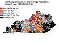
Population growth is centered along and between interstates I-65 and I-75.
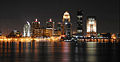
Louisville is the state's largest city with a metro population of 1.2 million.
- PhotodowntownLexKY.JPG
Lexington is the state's second largest city with a metro population of around 500,000.
Although Covington, Kentucky only has a population of 42,000, the Kentucky side of the Cincinnati/Northern Kentucky metropolitan area has a population of over 450,000.
- Picture 124NewportKYwaterfrnt.jpg
Newport's Aquarium and waterfront


Culture
Although Kentucky's culture is generally considered to be Southern, it is unique and also influenced by the Midwest and Southern Appalachia. The state is known for bourbon and whiskey distiling, tobacco, horse racing, and gambling. Kentucky is more similar to the Upper South in terms of ancestry which is predominantly American.[58] Neveretheless, during the 19th century, the state Kentucky did receive a substantial number of German and Irish immigrants, who settled primarily in the Midwest. Only Maryland, Delaware, and West Virginia, all also border states, have higher German ancestry percentages than Kentucky among Census-defined Southern states.[59] Kentucky was a slave state, and blacks once comprised over one-quarter of its population. However, it lacked the cotton plantation system and never had the same high percentage of African Americans as most other slave states. With less than 8% of its current population being black, Kentucky is rarely included in modern-day definitions of the Black Belt, despite a relatively significant rural African American population in the Central and Western areas of the state.[60][61][62] Kentucky adopted the Jim Crow system of racial segregation in most public spheres after the Civil War, but the state never disenfranchised African American citizens to the level of the Deep South states, and it peacefully integrated its schools after the 1954 Brown v. Board of Education verdict, later adopting the first state civil rights act in the South in 1966.[63]
The biggest day in horse racing, the Kentucky Derby, is preceded by the two-week Kentucky Derby Festival[64] in Louisville. Louisville also plays host to the Kentucky State Fair,[65] the Kentucky Shakespeare Festival,[66] and Southern gospel's annual highlight, the National Quartet Convention.[67] Owensboro, Kentucky's third largest city, gives credence to its nickname of "Barbecue Capital of the World" by hosting the annual International Bar-B-Q Festival.[68] Bowling Green, Kentucky's fifth largest city and home to the only assembly plant in the world that manufactures the Chevrolet Corvette,[69] opened the National Corvette Museum in 1994.[70]
The more rural communities are not without traditions of their own, however. Hodgenville, the birthplace of Abraham Lincoln, hosts the annual Lincoln Days Celebration, and will also host the kick-off for the National Abraham Lincoln Bicentennial Celebration in February 2008. Bardstown celebrates its heritage as a major bourbon-producing region with the Kentucky Bourbon Festival.[71] (Legend holds that Baptist minister Elijah Craig invented bourbon with his black slave in Georgetown, but some dispute this claim.)[72] Glasgow mimics Glasgow, Scotland by hosting the Glasgow Highland Games, its own version of the Highland Games,[73] and Sturgis hosts "Little Sturgis", a mini version of Sturgis, South Dakota's annual Sturgis Motorcycle Rally.[74] The residents of tiny Benton even pay tribute to their favorite tuber, the sweet potato, by hosting Tater Day.[75] Residents of Clarkson in Grayson County celebrate their city's ties to the honey industry by celebrating the Clarkson Honeyfest.[76] The Clarkson Honeyfest is held the last Thursday, Friday and Saturday in September, and is the "Official State Honey Festival of Kentucky."
State symbols
| Insignia | Symbol | Binomial nomenclature | Year Adopted[77] |
|---|---|---|---|
| Official State Bird | Cardinal | Cardinalis cardinalis | 1926 |
| Official State Butterfly | Viceroy Butterfly | Limenitis archippus | 1990 |
| Official State Dance | Clogging | 2001 | |
| Official State Beverage | Milk | 2005 | |
| Official State Fish | Kentucky Spotted Bass | Micropterus punctulatus | 2005 |
| Official State Fossil | Brachiopod | undetermined | 1985 |
| Official State Flower | Goldenrod | Soldiago gigantea | 1926 |
| Official State Fruit | Blackberry | Rubus allegheniensis | 2004 |
| Official State Gemstone | Freshwater Pearl | 1986 | |
| State Grass | Kentucky Bluegrass | Poa pratensis | Traditional |
| Official State Latin Motto | "Deo gratiam habeamus"
("With gratitude to God") |
2002 | |
| Official State Horse | Thoroughbred | Equus caballus | 1996 |
| Official State Mineral | Coal | 1998 | |
| Official State Outdoor Musical | "The Stephen Foster Story" (now called "Stephen Foster - The Musical") | 2002 | |
| Official State Instrument | Appalachian Dulcimer | 2001 | |
| State Nickname | "The Bluegrass State" | Traditional | |
| Official State Rock | Kentucky Agate | 2000 | |
| Official State Slogan | "Kentucky: Unbridled Spirit" | 2004[78] | |
| Official State Soil | Crider Soil Series | 1990 | |
| Official State Tree | Tulip Poplar | Liriodendron tulipifera | 1994 |
| Official Wild Animal Game Species | Gray Squirrel | Sciurus carolinensis | 1968 |
| Official State Song | "My Old Kentucky Home"
(revised version) |
1986 | |
| Official State Silverware Pattern | Old Kentucky Blue Grass:
The Georgetown Pattern |
1996 | |
| Official State Music | Bluegrass music | 2007[79] |
Gallery
Template:Cleanup-gallery
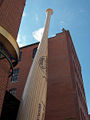
The world famous Louisville Slugger baseball bat is made in Kentucky.
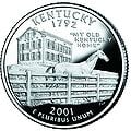
Kentucky's 2001 commemorative quarter.
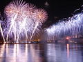
Thunder Over Louisville is the largest annual fireworks show in the world.
- Picture 1289.jpg
Kentucky's horse farms are world renowned.
The Daniel Boone National Forest.
- Picture 282.jpg
The Ohio River forms the northern border of Kentucky.
- DowntownBG.JPG
Many Kentucky cities have historic areas near downtown, such as this example in Bowling Green.
- US 23 KY.jpg
US Highway 23 cuts through the rugged Cumberland Plateau near Pikeville.
- 1890TornadoMemorial.jpg
Memorial to the victims of the great Louisville Tornado of 1890, which was the 20th deadliest in US History.
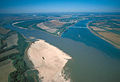
The largest river in North America, the Mississippi converges with the Ohio River along the Kentucky border near Wickliffe.


See also
| Kentucky Portal |
ReferencesISBN links support NWE through referral fees
- ↑ (1955) The North American Midwest: A Regional Geography. New York, New York: Wiley Publishers. ISBN 0901411931.
- ↑ Meyer, David R. (December 1989). Midwestern Industrialization and the American Manufacturing Belt in the Nineteenth Century. The Journal of Economic History 49 (4): 921–937.
- ↑ 3.0 3.1 3.2 (1987) "State Symbols", Encyclopedia of Kentucky. New York, New York: Somerset Publishers. ISBN 0403099811.
- ↑ 4.0 4.1 (1992) "Place Names", in John E. Kleber (ed.): The Kentucky Encyclopedia. Lexington, Kentucky: University Press of Kentucky.
- ↑ Kentucky. Microsoft Encarta Online Encyclopedia 2006. Retrieved 2007-02-25.
- ↑ Comments by Michael McCafferty on "Readers' Feedback (page 4)". The KryssTal. Retrieved 2007-02-23.
- ↑ Kentucky. Online Etymology Dictionary. Retrieved 2007-03-06.
- ↑ Life on the Mississippi. Kentucky Educational Television (2002-01-28). Retrieved 2006-11-29.
- ↑ The Geography of Kentucky - Climate. NetState.com (2006-06-15). Retrieved 2006-11-29.
- ↑ (1987) "Geographical Configuration", Encyclopedia of Kentucky. New York, New York: Somerset Publishers. ISBN 0403099811.
- ↑ (1992) "Rivers", in Kleber, John E.: The Kentucky Encyclopedia, Associate editors: Thomas D. Clark, Lowell H. Harrison, and James C. Klotter, Lexington, Kentucky: The University Press of Kentucky. ISBN 0813117720.
- ↑ (1992) "Lakes", in Kleber, John E.: The Kentucky Encyclopedia, Associate editors: Thomas D. Clark, Lowell H. Harrison, and James C. Klotter, Lexington, Kentucky: The University Press of Kentucky. ISBN 0813117720.
- ↑ Corbin, Kentucky: A Fisherman's Paradise. Corbin, Kentucky Economic Development. Retrieved 2006-11-29.
- ↑ Cumberland Falls State Resort Park. Kentucky Department of Parks (2005-10-19). Retrieved 2006-11-29.
- ↑ Mammoth Cave National Park. National Park Service (2006-10-12). Retrieved 2006-11-29.
- ↑ Bernheim Research Forest pp. 1. University of Louisville. Retrieved 4-30, 2007.
- ↑ Cite error: Invalid
<ref>tag; no text was provided for refs namedusgs - ↑ Bad Branch State Nature Preserve. Kentucky State Nature Preserves Commission. Retrieved 2006-11-29.
- ↑ Jefferson Memorial Forest. Retrieved 2006-11-29.
- ↑ The Presence. History of Native Americans in Central Kentucky. Mercer County Online. Retrieved 2006-11-29.
- ↑ Skinner, Constance. The Dark and Bloody Hunting Ground. Pioneers of the Old Southwest. WebBooks.com. Retrieved 2006-11-29.
- ↑ >Book Description for The Life of Daniel Boone: The Founder of the State of Kentucky and Colonel's Boone Autobiography. Amazon.com. Retrieved 2006-11-29.
- ↑ Dilger, Dr. Robert Jay. Monongalia County History. West Virginia University. Retrieved 2006-11-29.
- ↑ The Battle of Blue Licks. EarlyAmerica.com. Retrieved 2006-11-29.
- ↑ About Kentucky. Ezilon Search. Retrieved 2006-11-29.
- ↑ Constitution Square State Historic Site. Danville-Boyle County Convention and Visitors Bureau. Retrieved 2006-11-29.
- ↑ Border States in the Civil War. CivilWarHome.com (2002-02-15). Retrieved 2006-11-29.
- ↑ Ordinances of Secession. Historical Text Archive. Retrieved 2006-11-29.
- ↑ Civil War Sites - Bowling Green, KY. WMTH Corporation. Retrieved 2006-11-29.
- ↑ Irby, Jr., Richard E.. A Concise History of the Flags of the Confederate States of America and the Sovereign State of Georgia. About North Georgia. Golden Ink. Retrieved 2006-11-29.
- ↑ Marx, Karl (1861-07-05). Marx To Engels In Manchester. Marxists Internet Archive. Retrieved 2006-11-29.
- ↑ KRS 2.110 Public Holidays (PDF). Kentucky General Assembly. Retrieved 2006-11-29.
- ↑ The Old State Capitol. Kentucky Historical Society. Retrieved 2007-11-09.
- ↑ 2006 General Election Registration Figures Set. Kentucky Secretary of State (2006-10-19). Retrieved 2006-11-30.
- ↑ Election Results for Kentucky. CNN. Retrieved 2007-04-28.
- ↑ Reviser of Statutes Office - History and Functions. Kentucky Legislative Research Commission. Retrieved 2006-12-27.
- ↑ History of the DOCJT. Kentucky Department of Criminal Justice. Retrieved 2006-12-27.
- ↑ History of the Kentucky State Police. Kentucky State Police. Retrieved 2006-12-27.
- ↑ Authorized Methods of Execution by State. Death Penalty Information Center. Retrieved 2006-12-28.
- ↑ Long, Paul A, "'The Last Public Execution in America'", The Kentucky Post, E. W. Scripps Company, 2001-06-11. Retrieved 2006-12-27.
- ↑ Montagne, Renee (2001-05-01). The Last Public Execution in America. NPR. Retrieved 2006-12-27.
- ↑ McCreary County v. ACLU of Kentucky. Cornell University Law School. Retrieved 2006-12-27.
- ↑ Text of decision in ACLU of Kentucky v. Mercer County (PDF). Retrieved 2006-12-27.
- ↑ Price, Michael. Migration in Kentucky: Will the Circle Be Unbroken?. Exploring the Frontier of the Future: How Kentucky Will Live, Learn and Work pp. pp. 5–10. University of Louisville. Retrieved 4-30, 2007.
- ↑ Population and Population Centers by State: 2000 (TXT). U.S. Census Bureau. Retrieved 2006-12-27.
- ↑ 46.0 46.1 Census 2000 Map - Top U.S. Ancestries by County
- ↑ State Membership Report. The Association of Religion Data Archives (2000). Retrieved 2006-12-27.
- ↑ See E. Michael Rusten, The One Year Book of Christian History, Tyndale House, 2003, pp. 438–439. ISBN 0842355073.
- ↑ Kentucky Revival - Red River to Cane Ridge. Retrieved 2006-12-27.
- ↑ Kentucky Cabinet for Economic Development - Kentucky Economy
- ↑ Strong, Marvin. Kentucky: In the Middle of Auto Alley. Trade and Industry Development. Retrieved August, 2007.
- ↑ U.S. Department of Agriculture 2002 Census of Agriculture
- ↑ (March 2003). Kentucky Farm Numbers Increase. Kentucky Agri-News 22 (5).
- ↑ 2007 Rankings of States and Counties. bamabeef.org. Retrieved May, 2007.
- ↑ Corn Production Detective (PDF). National Council on Economic Education. Retrieved 2007-05-03.
- ↑ Unbridled Spirit→Information. State of Kentucky. Retrieved 2007-05-01.
- ↑ Kentucky State Data Center
- ↑ Brittingham, Angela & de la Cruz, G. Patricia (June 2004). Ancestry 2000: Census 2000 Brief (PDF). United States Census Bureau.
- ↑ 2000 Census: Percent Reporting Any German Ancestry. Retrieved 2007-07-20.
- ↑ Beale, Calvin (21 July 2004). High Poverty in the Rural U.S. and South: Progress and Persistence in the 1990s (PowerPoint).
- ↑ Womack, Veronica L. (23 July 2004). The American Black Belt Region: A Forgotten Place (PowerPoint).
- ↑ Unknown. Identifying the "Black Belt" of Cash-Crop Production (JPEG Image). Bowdoin College.
- ↑ Civil Rights and Women’s Rights. Retrieved 2007-07-20.
- ↑ Kentucky Derby Festival Home Page. Retrieved 2006-12-25.
- ↑ Kentucky State Fair. Retrieved 2006-12-25.
- ↑ Kentucky Shakespeare Festival Home Page. Retrieved 2006-12-25.
- ↑ National Quartet Convention Home Page. Retrieved 2006-12-25.
- ↑ Home Page of the International Barbecue Festival. Retrieved 2006-12-25.
- ↑ National Corvette Museum press release. Retrieved 2006-12-25.
- ↑ National Corvette Museum Home Page. Retrieved 2006-12-25.
- ↑ Kentucky Bourbon Festival Home Page. Retrieved 2006-12-25.
- ↑ How Bourbon Whiskey Really Got Its Famous Name. Retrieved 2006-12-25.
- ↑ Glasgow, Kentucky Highland Games Home Page. Retrieved 2006-12-25.
- ↑ Little Sturgis Rally Home Page. Retrieved 2006-12-25.
- ↑ Tater Day Festival A Local Legacy. Retrieved 2006-12-25.
- ↑ Clarkson Honeyfest home page. Retrieved 2007-05-12.
- ↑ Kentucky's State Symbols. Kentucky Department of Libraries and Archives. Retrieved 2006-12-18.
- ↑ Unbridled Spirit Information. Kentucky.gov (2006-11-20). Retrieved 2006-12-18.
- ↑ HB71: An act designating bluegrass music as the official state music of Kentucky (DOC). Legislative Research Commission. Retrieved 2007-06-26.
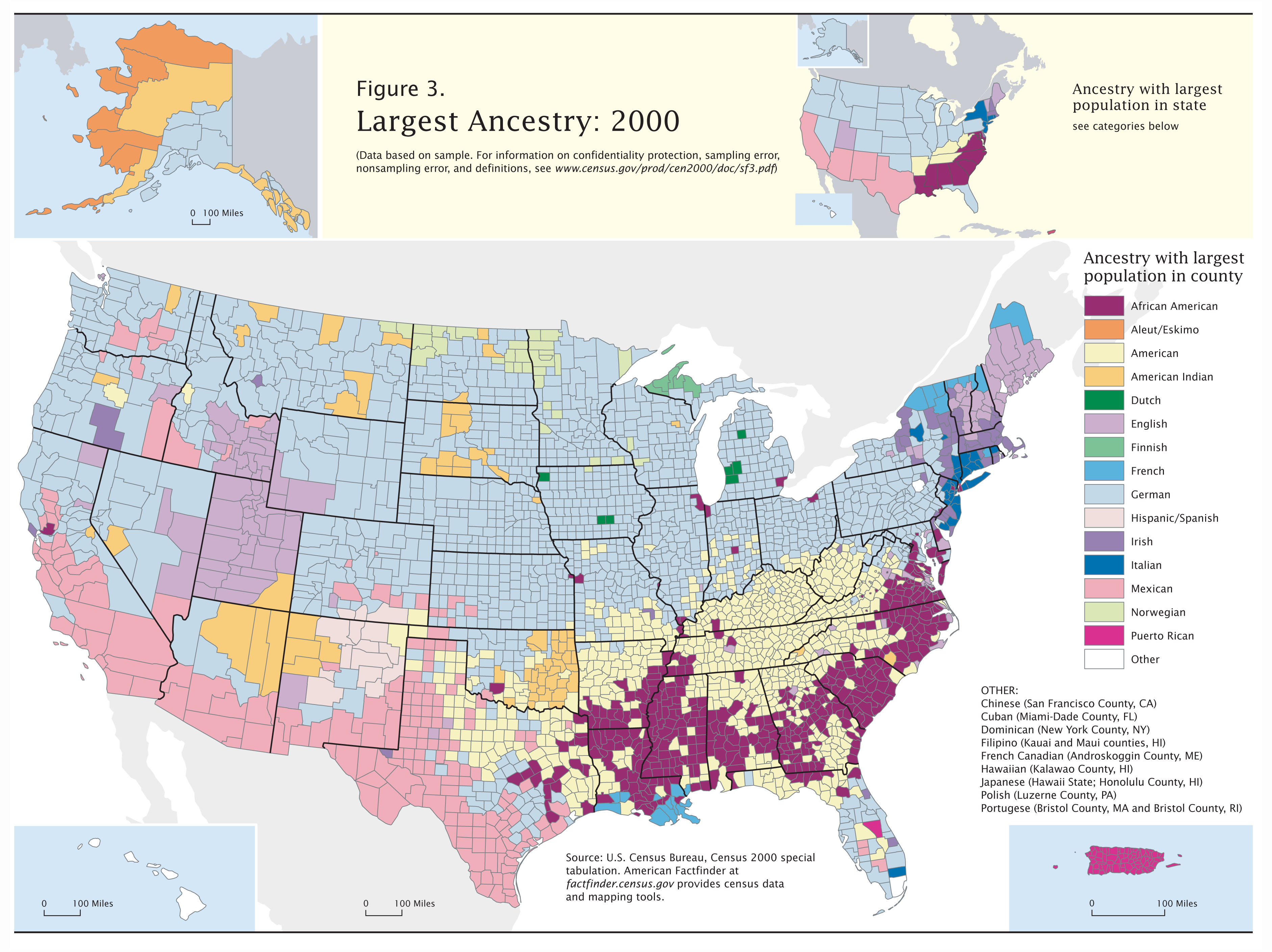
Bibliography
Politics
- Miller, Penny M. Kentucky Politics & Government: Do We Stand United? (1994)
- Jewell, Malcolm E. and Everett W. Cunningham, Kentucky Politics (1968)
History
Surveys and reference
- Bodley, Temple and Samuel M. Wilson. History of Kentucky 4 vols. (1928).
- Caudill, Harry M., Night Comes to the Cumberlands (1963). ISBN 0-316-13212-8
- Channing, Steven. Kentucky: A Bicentennial History (1977).
- Clark, Thomas Dionysius. A History of Kentucky (many editions, 1937–1992).
- Collins, Lewis. History of Kentucky (1880).
- Harrison, Lowell H. and James C. Klotter. A New History of Kentucky (1997).
- Kleber, John E. et al The Kentucky Encyclopedia (1992), standard reference history.
- Klotter, James C. Our Kentucky: A Study of the Bluegrass State (2000), high school text
- Lucas, Marion Brunson and Wright, George C. A History of Blacks in Kentucky 2 vols. (1992).
- Notable Kentucky African Americans http://www.uky.edu/Subject/aakyall.html
- Share, Allen J. Cities in the Commonwealth: Two Centuries of Urban Life in Kentucky (1982).
- Wallis, Frederick A. and Hambleton Tapp. A Sesqui-Centennial History of Kentucky 4 vols. (1945).
- Ward, William S., A Literary History of Kentucky (1988) (ISBN 0-87049-578-X).
- WPA, Kentucky: A Guide to the Bluegrass State (1939), classic guide.
- Yater, George H. (1987). Two Hundred Years at the Fall of the Ohio: A History of Louisville and Jefferson County, 2nd edition, Filson Club, Incorporated. ISBN 0-9601072-3-1.
Specialized scholarly studies
- Bakeless, John. Daniel Boone, Master of the Wilderness (1989)
- Blakey, George T. Hard Times and New Deal in Kentucky, 1929–1939 (1986)
- Coulter, E. Merton. The Civil War and Readjustment in Kentucky (1926)
- Davis, Alice. "Heroes: Kentucky's Artists from Statehood to the New Millennium" (2004)
- Ellis, William E. The Kentucky River (2000).
- Faragher, John Mack. Daniel Boone (1993)
- Fenton, John H. Politics in the Border States: A Study of the Patterns of Political Organization, and Political Change, Common to the Border States: Maryland, West Virginia, Kentucky, and Missouri (1957)
- Ireland, Robert M. The County in Kentucky History (1976)
- Klotter, James C. and Lowell Harrison, James Ramage, Charles Roland, Richard Taylor, Bryan S. Bush, Tom Fugate, Dixie Hibbs, Lisa Matthews, Robert C. Moody, Marshall Myers, Stuart Sanders and Stephen McBride (2005). in Jerlene Rose: Kentucky's Civil War 1861–1865. Back Home In Kentucky Inc. ISBN 0-9769231-1-4.
- Klotter, James C. Kentucky: Portrait in Paradox, 1900–1950 (1992)
- Pearce, John Ed. Divide and Dissent: Kentucky Politics, 1930–1963 (1987)
- Remini, Robert V. Henry Clay: Statesman for the Union (1991).
- Sonne, Niels Henry. Liberal Kentucky, 1780–1828 (1939)
- Tapp, Hambleton and James C Klotter. Kentucky Decades of Discord, 1865–1900 (1977)
- Townsend, William H. Lincoln and the Bluegrass: Slavery and Civil War in Kentucky (1955)
- Waldrep, Christopher Night Riders: Defending Community in the Black Patch, 1890–1915 (1993) tobacco wars
External links
- Kentucky.gov: My New Kentucky Home
- Kentucky State Databases - Annotated list of searchable databases produced by Kentucky state agencies and compiled by the Government Documents Roundtable of the American Library Association.
- Kentucky Department of Tourism
- The Kentucky Highlands Project
- USGS real-time, geographic, and other scientific resources of Kentucky
- Energy & Environmental Data for Kentucky
- Kentucky State Facts
- Kentucky: Unbridled Spirit
- Kentucky Virtual Library
- "Science In Your Backyard: Kentucky" U.S. Department of the Interior | U.S. Geological Survey, July 3, 2006, retrieved November 4, 2006
- U.S. Census Bureau Kentucky QuickFacts
- Interactive Kentucky for Kids
Template:Kentucky
| Political divisions of the United States | |||||||
|---|---|---|---|---|---|---|---|
| |||||||
| |||||
| Preceded by: Vermont |
List of U.S. states by date of statehood Admitted on June 1, 1792 (15th) |
Succeeded by: Tennessee |
Credits
New World Encyclopedia writers and editors rewrote and completed the Wikipedia article in accordance with New World Encyclopedia standards. This article abides by terms of the Creative Commons CC-by-sa 3.0 License (CC-by-sa), which may be used and disseminated with proper attribution. Credit is due under the terms of this license that can reference both the New World Encyclopedia contributors and the selfless volunteer contributors of the Wikimedia Foundation. To cite this article click here for a list of acceptable citing formats.The history of earlier contributions by wikipedians is accessible to researchers here:
The history of this article since it was imported to New World Encyclopedia:
Note: Some restrictions may apply to use of individual images which are separately licensed.