Difference between revisions of "River" - New World Encyclopedia
m (Robot: Remove claimed tag) |
Rosie Tanabe (talk | contribs) |
||
| (8 intermediate revisions by 3 users not shown) | |||
| Line 1: | Line 1: | ||
{{Copyedited}}{{Paid}}{{Images OK}}{{Submitted}}{{Approved}} | {{Copyedited}}{{Paid}}{{Images OK}}{{Submitted}}{{Approved}} | ||
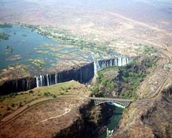
[[Image:Victoria5.jpg|thumb|250px|right|[[Zambezi River]] at [[Victoria Falls]] ([[Zambia]]/[[Zimbabwe]], Africa)]] | [[Image:Victoria5.jpg|thumb|250px|right|[[Zambezi River]] at [[Victoria Falls]] ([[Zambia]]/[[Zimbabwe]], Africa)]] | ||
| − | |||
| − | |||
A '''river''' is a natural [[waterway]] that conveys water derived from [[precipitation]] from higher ground to lower levels. Most commonly, rivers flow on the surface of the land, but there are also many examples of underground rivers, where the flow is contained within chambers, [[cave]]s, or [[cavern]]s. In some areas where the rainfall is highly variable, the rivers may carry water only occasionally, remaining dry for years at a time. Rivers sculpt the [[continent]]s. Many early [[civilization]]s began near the banks of rivers. | A '''river''' is a natural [[waterway]] that conveys water derived from [[precipitation]] from higher ground to lower levels. Most commonly, rivers flow on the surface of the land, but there are also many examples of underground rivers, where the flow is contained within chambers, [[cave]]s, or [[cavern]]s. In some areas where the rainfall is highly variable, the rivers may carry water only occasionally, remaining dry for years at a time. Rivers sculpt the [[continent]]s. Many early [[civilization]]s began near the banks of rivers. | ||
| − | + | {{toc}} | |
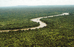
| + | [[Image:River_gambia_Niokolokoba_National_Park.gif|thumb|250px|River Gambia flowing through Niokolokoba National Park]] | ||
==Origins of river water== | ==Origins of river water== | ||
| − | |||
A river may have its [[Source_(river_or_stream)|source]] in a [[spring (hydrosphere)|spring]], [[lake]], from damp, [[bog|boggy]] places where the [[soil]] is waterlogged, from [[glacier|glacial]] meltwater, or simply from [[rain]] flowing off impermeable [[rock (geology)|rock]] or man-made surfaces. Almost all rivers are joined by other rivers and streams termed [[tributary|tributaries]], the highest of which are known as headwaters. Water may also be recruited to a river from groundwater sources. Throughout the course of the river, the total volume transported downstream will often be a combination of the free water flow together with a substantial contribution flowing through subsurface rocks and gravels that underlie the river and its floodplain. For many rivers in large valleys, this unseen component of flow may greatly exceed the visible flow. | A river may have its [[Source_(river_or_stream)|source]] in a [[spring (hydrosphere)|spring]], [[lake]], from damp, [[bog|boggy]] places where the [[soil]] is waterlogged, from [[glacier|glacial]] meltwater, or simply from [[rain]] flowing off impermeable [[rock (geology)|rock]] or man-made surfaces. Almost all rivers are joined by other rivers and streams termed [[tributary|tributaries]], the highest of which are known as headwaters. Water may also be recruited to a river from groundwater sources. Throughout the course of the river, the total volume transported downstream will often be a combination of the free water flow together with a substantial contribution flowing through subsurface rocks and gravels that underlie the river and its floodplain. For many rivers in large valleys, this unseen component of flow may greatly exceed the visible flow. | ||
| Line 18: | Line 16: | ||
==Topography== | ==Topography== | ||
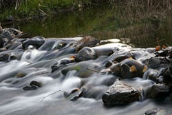
[[Image:Tambo river.jpg|thumb|250px|A river flowing over a slight change in topography]] | [[Image:Tambo river.jpg|thumb|250px|A river flowing over a slight change in topography]] | ||
| − | |||
A river's water is generally confined to a [[Channel (geography)|channel]], made up of a stream bed between banks. In larger rivers there is also a wider floodplain shaped by floodwaters overtopping the channel. Floodplains may be very wide in relation to the size of the river channel. This distinction between river channel and floodplain can be blurred especially in urban areas where the floodplain of a river channel can become greatly developed by housing and industry. | A river's water is generally confined to a [[Channel (geography)|channel]], made up of a stream bed between banks. In larger rivers there is also a wider floodplain shaped by floodwaters overtopping the channel. Floodplains may be very wide in relation to the size of the river channel. This distinction between river channel and floodplain can be blurred especially in urban areas where the floodplain of a river channel can become greatly developed by housing and industry. | ||
| Line 64: | Line 61: | ||
== Direction of flow == | == Direction of flow == | ||
| + | A misconception, particularly amongst schoolchildren and college students in North America, is that most—or even all—rivers flow from north to south.<ref>Bill Weiler, [http://amasci.com/miscon/opphys.html Operation Physics: Children's Misconceptions about Science,] American Institute of Physics (September 1998). Retrieved July 31, 2017.</ref><ref>William C. Philips, [http://k12s.phast.umass.edu/~nasa/misconceptions.html Earth Science Misconceptions.] Retrieved July 31, 2017.</ref> Rivers in fact flow downhill irrespective of direction and is often a complex meandering path involving all directions of the compass.<ref>Matt Rosenberg, [https://www.thoughtco.com/rivers-flowing-north-1435099 “Rivers Flowing North,”] ThoughtCo. Retrieved July 31, 2017.</ref><ref>Nezette Rydell, [http://www.madsci.org/posts/archives/mar97/858609276.Es.r.html Re: What determines the direction of river flow? Elevation, Topography, Gravity??] MadSci Network: Earth Sciences, Washington University Medical School. Retrieved July 31, 2017.</ref> | ||
| − | + | Studying the flows of rivers is one aspect of [[hydrology]].<ref>Cristi Cave, [http://chamisa.freeshell.org/flow.htm How a River Flows,] Stream Biology and Ecology. Retrieved July 31, 2017.</ref> | |
| − | |||
| − | Studying the flows of rivers is one aspect of [[hydrology]].<ref>Cristi Cave, [http://chamisa.freeshell.org/flow.htm How a River Flows,] Stream Biology and Ecology. Retrieved | ||
| − | |||
| − | |||
| − | |||
| − | |||
| − | + | == Well-known Rivers== | |
| − | + | (Listed in alphabetical order) | |
| − | |||
| − | |||
| − | |||
| − | |||
| − | |||
| − | |||
| − | |||
| − | |||
| − | |||
| − | |||
| − | |||
| − | |||
| − | |||
| − | |||
* The '''[[Amazon River]]''', the largest river in the world (in terms of volume and water cubic meters/second) | * The '''[[Amazon River]]''', the largest river in the world (in terms of volume and water cubic meters/second) | ||
| Line 185: | Line 163: | ||
* [[Towpath]] | * [[Towpath]] | ||
| − | == | + | == Notes == |
<references /> | <references /> | ||
==References== | ==References== | ||
| − | * Benke, Arthur C., and Colbert E. Cushing (eds.) | + | * Benke, Arthur C., and Colbert E. Cushing (eds.). ''Rivers of North America''. Burlington, MA: Elsevier Academic Press, 2005. ISBN 0120882531 |
| − | * Leopold, Luna B | + | * Leopold, Luna B. ''A View of the River.'' Cambridge, MA: Harvard University Press, 2003. ISBN 0674937325 |
| − | * McKnight, Tom L., and Darrel Hess | + | * McKnight, Tom L., and Darrel Hess. ''Physical Geography: Landscape Appreciation'', 8th ed. Upper Saddle River, NJ: Prentice Hall, 2004. ISBN 0131451391 |
| − | * Palmer, Tim | + | * Palmer, Tim. ''Rivers of America''. Harry N. Abrams, Inc., 2006. ISBN 0810954850 |
| − | * Scheffel, Richard L. (ed.) | + | * Scheffel, Richard L. (ed.). ''ABC's of Nature - A Family Answer Book''. Reader's Digest Association, 1988. {{ASIN|B000H3ZDPM}} |
| − | * Wolf, Aaron T. et al. "International River Basins of the World." ''International Journal of Water Resources Development'' 15(4) (Dec. 1999). | + | * Wolf, Aaron T. et al. [http://www.tandfonline.com/doi/abs/10.1080/07900629948682?journalCode=cijw20 "International River Basins of the World."] ''International Journal of Water Resources Development'' 15(4) (Dec. 1999). Retrieved July 31, 2017. |
| + | |||
== External links == | == External links == | ||
| − | All links retrieved | + | All links retrieved December 14, 2022. |
* [http://www.waterencyclopedia.com/Re-St/Rivers-Major-World.html "Rivers, Major World"] by Jeffrey W. Jacobs, ''Water Encyclopedia'' | * [http://www.waterencyclopedia.com/Re-St/Rivers-Major-World.html "Rivers, Major World"] by Jeffrey W. Jacobs, ''Water Encyclopedia'' | ||
| − | * [http://www. | + | * [http://www.gutenberg.org/ebooks/search/?query=River River] ''Project Gutenberg Library'' |
[[Category:Physical sciences]] | [[Category:Physical sciences]] | ||
Latest revision as of 01:43, 15 December 2022
A river is a natural waterway that conveys water derived from precipitation from higher ground to lower levels. Most commonly, rivers flow on the surface of the land, but there are also many examples of underground rivers, where the flow is contained within chambers, caves, or caverns. In some areas where the rainfall is highly variable, the rivers may carry water only occasionally, remaining dry for years at a time. Rivers sculpt the continents. Many early civilizations began near the banks of rivers.
Origins of river water
A river may have its source in a spring, lake, from damp, boggy places where the soil is waterlogged, from glacial meltwater, or simply from rain flowing off impermeable rock or man-made surfaces. Almost all rivers are joined by other rivers and streams termed tributaries, the highest of which are known as headwaters. Water may also be recruited to a river from groundwater sources. Throughout the course of the river, the total volume transported downstream will often be a combination of the free water flow together with a substantial contribution flowing through subsurface rocks and gravels that underlie the river and its floodplain. For many rivers in large valleys, this unseen component of flow may greatly exceed the visible flow.
From their source, all rivers flow downhill, typically terminating in the sea or in a lake. In arid areas rivers sometimes end by losing water to evaporation. River flow may also be lost by percolation into dry, porous material such as sand, soil, or into pervious rock. Excessive abstraction of water for use in industry, irrigation etc can also cause a river to dry before reaching a lake or the sea.
The mouth, or lower end, of a river is known by hydrologists as its base level.
The area drained by a river and its tributaries is called catchment, catchment basin, drainage basin or watershed. The term "watershed" is also used to mean a boundary between catchments, which is also called a water divide.
Topography
A river's water is generally confined to a channel, made up of a stream bed between banks. In larger rivers there is also a wider floodplain shaped by floodwaters overtopping the channel. Floodplains may be very wide in relation to the size of the river channel. This distinction between river channel and floodplain can be blurred especially in urban areas where the floodplain of a river channel can become greatly developed by housing and industry.
The river channel itself may contain a single stream of water but many rivers, if left unconstrained by human activity, will create several streams of water within a channel producing a braided river. Braided rivers can still be commonly seen in South Island New Zealand and on some of the larger river deltas.
A river flowing in its channel is a source of considerable energy which acts on the river channel to change its shape and form. In mountainous torrential zones, this can be seen in the form of erosion channels through hard rocks and the creation of sands and gravels from the destruction of larger rocks. In U-shaped glaciated valleys, the subsequent river valley can often easily be identified by the V-shaped channel that it has carved. In the middle reaches, where the river may flow over flatter land, loops (meanders) may form through eroding of the river banks and deposition on the inside of bends. Sometimes the river will cut off a loop, shortening the channel and forming an oxbow lake. Rivers that carry large amounts of sediment may develop conspicuous deltas at their mouths, if conditions permit. Rivers, whose mouths are in saline tidal waters, may form estuaries. River mouths may also be fjords or rias.
Although the following classes are a useful simplified way to visualize rivers, it is important to recognize there are other factors at work here. Gradient is controlled largely by tectonics, but discharge is controlled largely by climate and sediment load is controlled by various factors including climate, geology in the headwaters, and the stream gradient.
- Youthful river - a river with a steep gradient that has very few tributaries and flows quickly. Its channels erode deeper rather than wider. Examples include the Brazos River, Trinity River and Ebro River.
- Mature river - a river with a gradient that is less steep than those of youthful rivers and flows more slowly than youthful rivers. A mature river is fed by many tributaries and has more discharge than a youthful river. Its channels erode wider rather than deeper. Mature rivers are typified by the Mississippi River, Ohio River, and England’s Thames River.
- Old river - a river with a low gradient and low erosive energy. Old rivers are characterized by flood plains. Examples of old rivers include the Tigris River, Euphrates River in the Middle East and the Indus River.
- Rejuvenated river - a river with a gradient that is raised by tectonic uplift.
Flooding
Flooding is a natural part of a river's cycles. The majority of the erosion of river channels and the erosion and deposition on the associated floodplains occur during flood stage. Human activity, however, has upset the natural way flooding occurs by walling off rivers, straightening their courses and by draining of natural wetlands.
River ecosystems
The flora and fauna of rivers have developed to utilize the very wide range of aquatic habitats available, from torrential waterfalls to lowland mires. Although many organisms restrict themselves to the freshwater of rivers, some, such as salmon, spend different stages of their lives in rivers and the sea.
Human uses of rivers
Rivers have been useful for human existence since the dawn of civilization. They have served as sources of water and food, means of transport, lines of defense, sources of electric power to drive machinery, and waste disposal sites. Even today, many major cities are situated near rivers.
In addition, rocks and gravel generated and moved by rivers have been useful for construction projects. In recent generations, the beauty of rivers and their surrounding habitat has contributed greatly to local economies by attracting income from tourism. In upland rivers, one often observes waterfalls and whitewater rapids. Waterfalls are sometimes used as sources of energy, by way of watermills and hydroelectric plants, and rapids are often used for recreational purposes.
Management
Rivers are often managed or controlled to make them more useful and less disruptive to human activity.
- Dams (see above) or weirs may be built to control the flow, store water, or extract energy.
- Levees may be built to prevent run-off of excess river water in times of flood.
- Canals connect rivers to one another for water transfer or navigation.
- River courses may be modified to improve navigation, or straightened to increase the flow rate.
River management is an ongoing activity, as rivers tend to 'undo' the modifications made by man. Dredged channels silt up, sluice mechanisms deteriorate with age, levees and dams may suffer seepage or catastrophic failure. The benefits sought through managing rivers may often be offset by the social and economic costs of mitigating the effects of such management. For example, in many parts of the developed world, rivers have been confined to channels to free up flat flood-plain land for development. Subsequent extreme flooding events can inundate such development at high financial costs and often with loss of life.
Geopolitical boundaries
Rivers have been important historically in determining political boundaries. For example, the Danube was a longstanding border of the Roman Empire, and today forms most of the border between Bulgaria and Romania. The Mississippi in North America, and the Rhine in Europe, are major east-west boundaries in those continents. The Orange River forms the boundary between various provinces and countries along its route in Africa.
Direction of flow
A misconception, particularly amongst schoolchildren and college students in North America, is that most—or even all—rivers flow from north to south.[1][2] Rivers in fact flow downhill irrespective of direction and is often a complex meandering path involving all directions of the compass.[3][4]
Studying the flows of rivers is one aspect of hydrology.[5]
Well-known Rivers
(Listed in alphabetical order)
- The Amazon River, the largest river in the world (in terms of volume and water cubic meters/second)
- Amu Darya, the longest river in central Asia
- The Amur, the principal river of eastern Siberia and the border between Russia and China
- The Arno, the river that runs through Florence
- The Arvandrud (Shatt al-Arab), the river that borders Iran and Iraq
- The Brahmaputra, the principal river in northeast India and Tibet
- The Chao Phraya, the principal river of Thailand
- The River Clyde, which runs through Glasgow
- The Colorado River (in Argentina)
- The Colorado River (in the United States), the principal river of the American Southwest
- The Columbia River, the principal river of the Pacific Northwest United States
- The Congo, the principal river of central Africa
- The Danube, the principal river of central and southeastern Europe
- Río de la Plata, the widest river in the world
- The Dnieper River, one of the main rivers of Russia, Belarus and Ukraine.
- The Ebro, a river in northwestern Spain
- The Elbe, a major German river, running through the city of Hamburg
- The Euphrates, one of the twin principal rivers of Anatolia (Turkey) and Mesopotamia (Iraq)
- The Ganga, the principal river of India
- Han-gang, the river that runs through Seoul
- The Helmand River, the principal river of Afghanistan
- The Huang He (or Yellow River), one of the principal rivers of China
- The Hudson River, the principal river of New York State
- The Indus River, the principal river of Pakistan
- The James River. the principal river of Virginia in the USA, historically important.
- The River Jordan, the principal river of Palestine, Jordan, and Israel
- The Lena, the principal river of northeastern Siberia
- The Mackenzie River, the longest river in Canada
- The Magdalena, the principal river of Colombia
- The Main, a river in Germany which runs through Frankfurt am Main
- The Mekong, a principal river of Southeast Asia
- The Maas, the principal river of the southern provinces of the Netherlands and eastern Belgium
- The Mississippi River, the principal river of the central and southern United States
- The Missouri River, one of the principal rivers of the Great Plains
- The Murray River, the principal river of southeastern Australia
- The Niagara River, the river which flows between Lake Erie and Lake Ontario, and which flows over Niagara Falls
- The Niger, the principal river of west Africa
- The Nile, the longest river in the world, principal to Egypt and northeastern Africa
- The Ob, a large river of Siberia
- The Oder, a major river in Central Europe
- The Ohio River, the largest river between the Mississippi and the Appalachian Mountains
- The Orinoco, the principal river of Venezuela
- The Rhine, one of the longest and most important rivers in Europe
- The Rio Grande, the river that forms part of the border between the United States and Mexico
- The Saint Lawrence River, which drains the Great Lakes
- The São Francisco River, the longest river wholly within Brazil
- The Sava, which flows through four countries—Slovenia, Croatia, Bosnia and Herzegovina (making its northern border) and Serbia—and was therefore one of the symbols of former Yugoslavia
- The Seine, the river that runs through Paris
- The Segura, a river in southeastern Spain
- The River Severn, the longest river in Great Britain
- Shinano-gawa, the longest river in Japan
- The Susquehanna River, the principal river of Pennsylvania and the Chesapeake Bay
- Tajo or Tejo, the largest river in the Iberian Peninsula
- The Thames, the river that runs through London
- The Tiber, the river that runs through Rome
- The Tigris, one of the twin principal rivers of Anatolia (Turkey) and Mesopotamia (Iraq)
- Tonegawa, one of the largest rivers in Japan
- The Vistula, the principal river of Poland
- The Vltava, the river that runs through Prague
- The Volga River, the principal river of Russia and the longest river in Europe
- The Yangtze (Chang Jiang), the longest river in China and Asia
- The Yenisei, a large river in Siberia
- The Yukon, the principal river of Alaska and the Yukon Territory
- The Zambezi, the principal river of southeastern Africa
Rating systems
- International Scale of River Difficulty - The scale is used to rate the challenges of navigation—particularly those with rapids. Class I is the easiest and Class VI is the hardest.
- Strahler Stream Order - a method to rank rivers based on the connectivity and hierarchy of contributing tributaries. Headwaters are considered first order, while the Amazon River is twelfth order. Approximately 80 percent of the rivers and streams on Earth are of the first and second order.
See also
Crossings
Rivers may be crossed by:
Transport
- Barge
- Riverboat
- Sailing
- Towpath
Notes
- ↑ Bill Weiler, Operation Physics: Children's Misconceptions about Science, American Institute of Physics (September 1998). Retrieved July 31, 2017.
- ↑ William C. Philips, Earth Science Misconceptions. Retrieved July 31, 2017.
- ↑ Matt Rosenberg, “Rivers Flowing North,” ThoughtCo. Retrieved July 31, 2017.
- ↑ Nezette Rydell, Re: What determines the direction of river flow? Elevation, Topography, Gravity?? MadSci Network: Earth Sciences, Washington University Medical School. Retrieved July 31, 2017.
- ↑ Cristi Cave, How a River Flows, Stream Biology and Ecology. Retrieved July 31, 2017.
ReferencesISBN links support NWE through referral fees
- Benke, Arthur C., and Colbert E. Cushing (eds.). Rivers of North America. Burlington, MA: Elsevier Academic Press, 2005. ISBN 0120882531
- Leopold, Luna B. A View of the River. Cambridge, MA: Harvard University Press, 2003. ISBN 0674937325
- McKnight, Tom L., and Darrel Hess. Physical Geography: Landscape Appreciation, 8th ed. Upper Saddle River, NJ: Prentice Hall, 2004. ISBN 0131451391
- Palmer, Tim. Rivers of America. Harry N. Abrams, Inc., 2006. ISBN 0810954850
- Scheffel, Richard L. (ed.). ABC's of Nature - A Family Answer Book. Reader's Digest Association, 1988. ASIN B000H3ZDPM
- Wolf, Aaron T. et al. "International River Basins of the World." International Journal of Water Resources Development 15(4) (Dec. 1999). Retrieved July 31, 2017.
External links
All links retrieved December 14, 2022.
- "Rivers, Major World" by Jeffrey W. Jacobs, Water Encyclopedia
- River Project Gutenberg Library
Credits
New World Encyclopedia writers and editors rewrote and completed the Wikipedia article in accordance with New World Encyclopedia standards. This article abides by terms of the Creative Commons CC-by-sa 3.0 License (CC-by-sa), which may be used and disseminated with proper attribution. Credit is due under the terms of this license that can reference both the New World Encyclopedia contributors and the selfless volunteer contributors of the Wikimedia Foundation. To cite this article click here for a list of acceptable citing formats.The history of earlier contributions by wikipedians is accessible to researchers here:
The history of this article since it was imported to New World Encyclopedia:
Note: Some restrictions may apply to use of individual images which are separately licensed.
