Great Plains
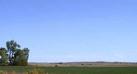
The Great Plains are the broad expanse of prairie and steppe that lie east of the Rocky Mountains in the United States and Canada. This area covers parts of the U.S. states of Colorado, New Mexico, Texas, Oklahoma, Kansas, Nebraska, South Dakota, North Dakota, Montana, and Wyoming, and the Canadian provinces of Alberta, Saskatchewan, and Manitoba. In Canada, the term "prairie" is more common, and the region is known as the Prairie Provinces or simply "the Prairies."
The region covers almost 500Â miles (800Â km) east to west and 3,000Â miles (4,800Â km) north to south. Much of the region was home to Native American tribes and enormous bison herds until their decimation during the mid/late 1800s.
Many areas of the Great Plains have become productive crop-growing areas due in part to extensive irrigation. While agriculture remains an important industry, it is no longer the major activity of most plains inhabitants. In the later half of the twentieth and twenty first centuries population has become more concentrated in urban areas. Employment is most often found largely in services, tourism, light manufacturing, construction, finance, insurance, and technology.
The "wide open plains" has shaped the character of its people, who have a dynamic respect for the land and the forces and wonder of nature.
Geography
The traditional line for marking the eastern boundary of the Great Plains was the 100th west meridian, but others say it should be drawn farther to the east, near the 97th meridian, and based on the amount of rainfallâbetween an area that receives 20 inches (500 mm) or more of rainfall per year and one that receives less than 20 inches (500 mm). This rainfall line divides the drier plains from the moister prairies. Still others accept the 95th meridian as the eastern demarcation. Political geographers have gravitated toward the Missouri River for some finality.[1]
The Great Plains are the westernmost portion of the vast North American Interior Plains, which extend east to the Appalachian Plateau. The region is a high plateau that ranges from an altitude at the base of the Rocky Mountains of 5,000 to 6,000 feet (1,500 to 1,800 m) to 1,500 feet at the eastern edge.
In the United States, water from the Rocky Mountains drains eastward via the Missouri River and its tributaries (the Yellowstone, Platte, and Kansas Rivers) as well as the Red, Rio Grande, and Arkansas rivers. The Red River of the North forms the boundary between North Dakota and Minnesota, then drains into Canada. In Canada, the main drainage is down the Saskatchewan River and its tributaries.
The sub-arid climate excludes tree growth and opens far-reaching views. The plains evince various stages of erosional development and are occasionally interrupted by buttes, escarpments, and valleys. Yet on the whole, a broadly extended surface of moderate relief so often prevails that the name Great Plains for the region as a whole is well deserved.
Climate

Because of its location east of the Rocky Mountains, the Great Plains receive little precipitation and can be semi-arid in some areas except near rivers and streams. Rainfall may vary from less than 10 inches (25 cm) per year on the high plains to around 45 inches (112 cm) per year where the tallgrass prairie blends into the eastern deciduous forest. The annual swing of temperature can be as much as 130 degrees Fahrenheit (55 degrees Celsius) between winter and summer. Weather systems typically move fast on the Great Plains, stirring up the atmosphere. Winters are very cold, though chinook winds may bring brief spring-like conditions in the western regions. The region is periodically subjected to extended periods of drought; high winds in the region may then generate devastating dust storms.
Geology
From 570 million until about 70 million years ago, shallow seas lay across the interior of the North American continent. Layered sediments, mostly between 5,000 and 10,000 feet thick, was deposited and eventually consolidated into rock. The sediments rest on a floor of very old rocks. About 70 million years ago the seas were displaced from the interior by slow uplift of the continent, and the landscape that appeared was the extensive, nearly flat floor of the former sea.

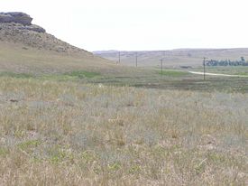

The initial, nearly horizontal layers of rock beneath the Interior Plains have been little disturbed except where mountains like the Black Hills were uplifted about 70 million years ago. At those places, which are all in the northern and southern parts of the Great Plains, the sedimentary layers were warped up and locally broken by the rise of hot molten rock from the depths. Elsewhere in the Interior Plains, however, earth forces of about the same period caused only a re-emphasis of gentle undulations in Earth's crust.
Farther west, in the area of the present Rocky Mountains, the land was being uplifted at a great rate along a relatively narrow north-trending belt, extending from Mexico to Alaska. The layers of sedimentary rock deposited in the inland sea were stripped from the crest of the rising mountainous belt by erosion and transported to its flanks as the gravel, sand, and mud of streams and rivers. This transported sediment was deposited on the plains.
Vegetation thrived on this alluvial plain, and thick accumulations of woody debris were buried to ultimately become coal. As the mountains continued to rise, the eroding streams cut into the old core rocks of the mountains, and that debris too was carried to the flanks and onto the adjoining plains. The mountainous belt continued to rise intermittently, and volcanoes began to appear about 50 million years ago. Together, the mountains and volcanoes provided huge quantities of sediment, which the streams transported to the plains and deposited. Vegetation continued to flourish, especially in the northern part of the Great Plains, and was buried to form the thick coal beds of the Fort Union Formation.
Sometime between 5 and 10 million years ago, however, a great change took place, apparently as a result of regional uplift of the entire western part of the continent. While the streams had been depositing sediment on the plains for more than 60 million years, now the streams were forced to cut down into and excavate the sediments they had formerly deposited. As uplift continued the streams cut deeper and deeper into the layered stack and developed tributary systems that excavated broad areas. High divides were left between streams in some places, and broad plateaus were formed and remain in other places. The great central area was essentially untouched by erosion and remained standing above the dissected areas surrounding it as the escarpment-rimmed plateau that is the High Plains.
This downcutting and excavation by streams roughed out the landscape of the Great Plains and created the sections we call the Missouri Plateau, the Colorado Piedmont, the Pecos Valley, the Edwards Plateau, and the Plains Border Section. Nearly all the individual landforms that now exist were created by geologic processes during the last 2 million years.
The United States Geological Survey divides the Great Plains in the United States into 10 subdivisions:
- Missouri Plateau, glaciatedâeast-central South Dakota, northern and eastern North Dakota, and northeastern Montana
- Missouri Plateau, unglaciatedâwestern South Dakota, northeastern Wyoming, southwestern South Dakota, and southeastern Montana
- Black Hillsâwestern South Dakota
- High Plainsâeastern New Mexico, northwestern Texas, western Oklahoma, eastern Colorado, western Kansas, most of Nebraska (including the Sand Hills), and southeastern Wyoming
- Plains Borderâcentral Kansas and northern Oklahoma (including the Flint, Red and Smoky Hills)
- Colorado Piedmontâeastern Colorado
- Raton sectionânortheastern New Mexico
- Pecos Valleyâeastern New Mexico
- Edwards Plateauâsouth-central Texas
- Central Texas sectionâcentral Texas
Canadian prairies
The Prairies is a Canadian terrestrial ecozone that spans the southern areas of the Prairie provinces of Alberta, Saskatchewan, and Manitoba. The ecozone transformed into a relatively treeless grassland following the last glacial retreat from 11,000 to 8,000 years ago. Today it is a productive agricultural area commonly referred to as "Canada's breadbasket." Farmland covers about 94 percent of the land and is the dominant domestic economic activity of the zone, as well as an important factor in Canadian foreign trade. Natural gas and oil are abundant in the area. Characterized by vast tracts of flat and rolling plains, it nonetheless exhibits a variety of relief, including hummocky lands and deep river valleys.
Despite the predominance of farming, less than 10 percent of the population is involved in agriculture. It is a highly urbanized area, with all the major population centers of these provinces located in this ecozone. Nearly 80 percent of the region's four million inhabitants live in urban areas.
Flora and fauna
Because of their extent and unusual features, the Great Plains provides a variety of environments and extremes of climate. The desert of the Southwestern United States is the home of drought-adapted plants and animals. To the east, deciduous forest species can be found among the grasses. In Canada, the northern edge of the grassland is bounded by coniferous forests.
The isolated mountainous areas, such as the Black Hills of South Dakota and the Wichita Mountains of Oklahoma, are like islands in the prairie and often contain species whose nearest relatives may be hundreds of miles away. Along rivers, streams and the many natural and man-made lakes live aquatic plants and the animals that depend on them. The wetland habitats of the prairie are very significant. Half of all North American shorebirds stop over at Cheyenne Bottoms in Kansas during the spring migration.
Near the Rocky Mountains, shortgrass prairie covers the high plains. In the east, tallgrass predominates where it still exists. Between the tallgrass and the shortgrass prairie lies a shifting band of habitat that has both tall and short grasses, yet is distinguishable as a separate communityâthe mixed prairie.[2] Any animal that lives on the Great Plains must be adapted for the grassland ecosystem and extremes of climate.
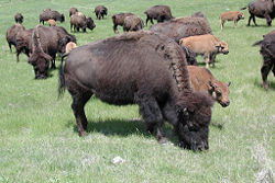
Lizards, snakes, and turtles are among the reptiles to be found. The American bison is the most famous animal of the Great Plains. Its herds were reduced from about 30 million in the 1500s to about 1,000 individuals, though the species has made a recovery. Other mammals are ground squirrels, beavers, prairie dogs, rabbits, foxes, and coyotes.
Migrating shorebirds need areas for resting and feeding, and several of these areas are found within the Great Plains. Although most people associate shorebirds with wetlands and ocean shorelines, many species use shortgrass, tallgrass, and mixed grass prairies for at least part of their life cycle.
History
Pre-European contact

Historically, the Great Plains were the range of the bison and of the Native American tribes of the Blackfeet, Crow, Sioux, Cheyenne, Arapaho, Comanche, and others. Eastern portions of the Great Plains were inhabited by tribes that lived in semipermanent villages of earth lodges, such as the Arikara, Mandan, Pawnee, and Wichita.
European contact
The first recorded history of Europeans in the Great Plains happened in Texas, Kansas, and Nebraska from 1540-1542 with the arrival of Francisco VĂĄsquez de Coronado, a Spanish conquistador. In that same period, Hernando de Soto crossed in a west-northwest direction in what is now Oklahoma and Texas. The Spanish thought the Great Plains were the location of the mythological Quivira and CĂbola, a place rich in gold. The arrival of horses with the Spanish gave impetus to the Native American culture of the Plains.
In the next hundred years the fur trade attracted thousands of Europeans to the Great Plains, as fur trappers from France, Spain, Britain, Russia, and the young United States made their way across much of the region. After the Louisiana Purchase in 1803 and subsequent Lewis and Clark Expedition in 1804, the Great Plains became more accessible. Early settlements opened the door to vast westward expansion, including many European immigrants, in both the United States and Canada.
Pioneer settlement
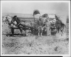

The move of pioneers onto the plains eventually led to the near-extinction of the buffalo and the removal of the Native Americans to reservations on marginal land in the mid-nineteenth century. Much of the Great Plains became open range, hosting ranching operations where anyone was theoretically free to run cattle. In the spring and fall, roundups were held and the new calves were branded and the cattle sorted out for sale. Ranching began in Texas and gradually moved northward. Texas cattle were driven north to railroad lines in cities such as Dodge City, Kansas, and Ogallala, Nebraska; from there, cattle were shipped eastward. Many foreign, especially British, investors financed the great ranches of the era. Overstocking of the range and the terrible winter of 1886 eventually resulted in a disaster, with many cattle starved and frozen. From then onward, ranchers generally turned to raising feed in order to winter their cattle over.
The American Homestead Act of 1862 allowed a settler to claim up to 160 acres (65 hectares) of land, provided that he lived on it for a period of five years and cultivated it. This was later expanded under the Kinkaid Act to include a homestead of an entire section. Hundreds of thousands of people claimed these homesteads, sometimes building sod houses. Many of them were not skilled dryland farmers and failures were frequent. Germans from Russia who had previously farmed in similar circumstances in what is now Ukraine were marginally more successful than the average homesteader.
After 1900
The region roughly centered on the Oklahoma Panhandle, including southeastern Colorado, southwestern Kansas, the Texas Panhandle, and extreme northeastern New Mexico was known as the Dust Bowl during the late 1920s and early 1930s. The drought, combined with the effects of the Great Depression, forced many farmers off the land throughout the Great Plains.
From the 1950s, on, many areas of the Great Plains have become productive crop-growing areas because of extensive irrigation. The southern portion of the Great Plains lies over the Ogallala Aquifer, a vast underground layer of water-bearing strata dating from the last ice age. Center pivot irrigation is used extensively in drier sections of the Great Plains, resulting in aquifer depletion at a rate that is greater than the ground's ability to recharge.
Economy
With the movement of people from rural areas, commerce has shifted from its traditional foundation in agriculture. From 1989 to 1999, earnings by persons employed in various industries became concentrated in areas such as services, tourism, light manufacturing, construction, finance, insurance, and technology. The national average wage and salary disbursement is $32,702, whereas in Plains states, these figures range from $23,178 to $27,411, in some cases nearly $10,000 less than the rest of the country. Seven of the ten poorest counties in the United States are in the Great Plains.[1]
Demographics and culture
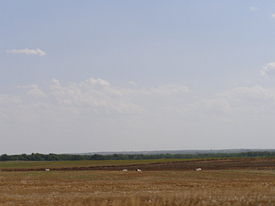
The population of the Plains is growing, says John Wunder, professor of history at the University of Nebraska-Lincoln. According to the most recent United States census, all the states in the Plains region experienced growth from 1990 to 2000, with the white population showing the slowest average rate of growth, in large part due to an increase in other races. The regional average shows growth rates of 18.7 percent for African Americans, 17.1 percent for Native Americans, 48.0 percent for Asians, 50.0 percent for Pacific Islanders, and 107.8 percent for Hispanics.[1]
Once thought to be largely rural and agrarian, those who live on the Plains are more and more occupying municipalities. The Plains is the most urbanized of all the regions of the United States; the majority of people in each of the five states is distributed in the 15 most populated cities.
The historian James Malin, an expert on environmental history, noted the character of peoples based upon their environments. People of the Great Plains were molded by their Plains experiences, expressed through a dynamic respect for the land and acknowledgment of cultural change and retention.[3] The connection between the people and the land cannot be overlooked or ignored.
To describe the Great Plainsâboth the land and the peopleâone must use the term "wide open space." The vastness of the Plains has created a vastness in the mindset of its inhabitants. It is not unusual for people on the Plains to travel hundreds of miles to hear a concert, attend a powwow, participate in soccer or baseball tournaments, or even attend church.
This vastness of mind has also engendered a passion for the humanities: The Plains states are home to five of the strongest humanities councils in the U.S. The Nebraska State Legislature created the first-ever state endowment fund for its humanities and arts councils.[1]
Looking to the future

While the population of the Plains is growing overall, the rural Plains have lost a third of their population since 1920. Several hundred thousand square miles of the Great Plains have fewer than six persons per square mileâthe density standard historian Frederick Jackson Turner used to declare the American frontier "closed" in 1893. Many have fewer than two persons per square mile. There are more than 6,000 ghost towns in Kansas alone, according to Kansas historian Daniel Fitzgerald. This problem is often exacerbated by the consolidation of farms and the difficulty of attracting modern industry to the region. In addition, the smaller school-age population has forced the consolidation of school districts and the closure of high schools in some communities. This continuing population loss has led some to suggest that the current use of the drier parts of the Great Plains is not sustainable, and propose that large parts be restored to native grassland grazed by bison.
Wind power
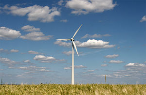
The Great Plains contribute substantially to wind power in the United States. In July 2008, oilman turned wind-farm developer T. Boone Pickens called for an investment of $1 trillion to build an additional 200,000 MW of wind power capacity in the Plains. Pickens cited Sweetwater, Texas, as an example of economic revitalization driven by wind power development.[4] [5][6] Sweetwater was a struggling town typical of the Plains, steadily losing businesses and population, until wind turbines came to the surrounding Nolan County.[7] Wind power brought jobs to local residents, along with royalty payments to landowners who leased sites for turbines, reversing the town's population decline. Pickens claims the same economic benefits are possible throughout the Plains, which he refers to as North America's "wind corridor." By 2006, Texas surpassed California as the U.S. state with the most installed wind energy capacity. South Dakota has the potential to be the nation's largest wind energy provider. In 2008, it produced enough energy to supply 15,000 homes with power. With the inclusion of a pending 306-megawatt wind farm, said Dusty Johnson, chairman of the Public Utilities Commission, the number of residents supplied would double. But transmission lines are also needed.[8]
Notes
- â 1.0 1.1 1.2 1.3 John Wunder, An Overview of the Great Plains, University of Nebraska-Lincoln. Retrieved January 28, 2009.
- â Great Plains Nature Center, Flora and Fauna of the Great Plains. Retrieved February 7, 2009.
- â James C. Malin, Grassland Historical Studies: Natural Resources Utilization in a Background of Science and Technology (1950).
- â Star Tribune, July 25, 2008, Legendary Texas oilman embraces wind power. Retrieved January 29, 2009.
- â Anna Fahey, July 9, 2008, Texas Oil Man Says We Can Break the Addiction, Sightline Daily. Retrieved January 29, 2009.
- â Wind Today Magazine, May 16, 2008, T. Boone Pickens Places $2 Billion Order for GE Wind Turbines.
- â Ben Block, July 24, 2008, In Windy West Texas, An Economic Boom, World Changing. Retrieved January 29, 2009.
- â Danny Andrews, January 22, 2009, S.D. experts see potential for growth in wind power, Madison Daily Leader. Retrieved January 24, 2009.
ReferencesISBN links support NWE through referral fees
- Bonnifield, Paul. The Dust Bowl: Men, Dirt, and Depression. Albuquerque, NM: University of New Mexico Press, 1979. ISBN 0826304850.
- Fairchild, D.H. and J.E. Klete. Woody Landscape Plants for the High Plains. Colorado State University, Technical Bulletin LTB93-1. 1993.
- Gilfillan, Merrill. Chokecherry Places, Essays from the High Plains. Boulder, CO: Johnson Press. ISBN 1555662277.
- Grant, Michael J. Down and Out on the Family Farm: Rural Rehabilitation in the Great Plains, 1929-1945. University of Nebraska Press, 2002. ISBN 0803271050.
- Hamil, Harold. Colorado Without Mountains, A High Plains Memoir. Kansas City, MO: Lowell Press, 1976. ISBN 0913504335.
- Haruf, Kent. The Tie That Binds. Vintage Books, 2000. ISBN 0375724389.
- Malin, James C. Grassland Historical Studies: Natural Resources Utilization in a Background of Science and Technology. Lawrence, KS: The Author. 1950.
- Stegner, Wallace. Wolf Willow. A History, a Story, and a Memory of the Last Plains Frontier. New York: Viking Compass Book, 1966. ISBN 067000197X.
- Wishart, David J. Encyclopedia of the Great Plains. University of Nebraska Press, 2004. ISBN 0803247877.
External links
All links retrieved May 24, 2024.
- Native Kansas Prairie
- The Northern Great Plains
- University of Nebraska-Lincoln: Center for Great Plains Study
Credits
New World Encyclopedia writers and editors rewrote and completed the Wikipedia article in accordance with New World Encyclopedia standards. This article abides by terms of the Creative Commons CC-by-sa 3.0 License (CC-by-sa), which may be used and disseminated with proper attribution. Credit is due under the terms of this license that can reference both the New World Encyclopedia contributors and the selfless volunteer contributors of the Wikimedia Foundation. To cite this article click here for a list of acceptable citing formats.The history of earlier contributions by wikipedians is accessible to researchers here:
The history of this article since it was imported to New World Encyclopedia:
Note: Some restrictions may apply to use of individual images which are separately licensed.
