Tajikistan
| Ҷумҳурии Тоҷикистон Jumhurii Tojikiston Republic of Tajikistan | |||||
| |||||
| Motto: none | |||||
| Anthem: Surudi Milli | |||||
| Capital (and largest city) |
38°33′N 68°48′E | ||||
| Official languages | Persian (Tajik (Tajiki Persian) is the official dialect) | ||||
|---|---|---|---|---|---|
| Government | Unitary republic | ||||
| - President | Emomali Rahmonov | ||||
| - Prime Minister | Okil Okilov | ||||
| Independence | |||||
| - Declared | September 9 1991 | ||||
| - Completed | December 25 1991 | ||||
| - Establishment of the Samanid Empire | 875 C.E. | ||||
| Area | |||||
| - Total | 143,100 km² (95th) 55,251 sq mi | ||||
| - Water (%) | 0.3 | ||||
| Population | |||||
| - July 2006 estimate | 7,320,0001 | ||||
| - 2000 census | 6,127,000 | ||||
| - Density | 45/km² 117/sq mi | ||||
| GDP (PPP) | 2005 estimate | ||||
| - Total | $8.802 billion | ||||
| - Per capita | $1,388 | ||||
| HDI (2004) | |||||
| Currency | Somoni (TJS)
| ||||
| Time zone | TJT (UTC+5) | ||||
| Internet TLD | .tj | ||||
| Calling code | +992 | ||||
| 1 Rank based on UN figures for 2005; estimate based on CIA figures for 2006. | |||||
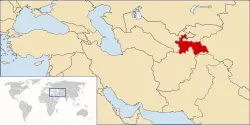
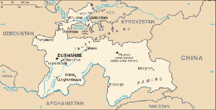
Tajikistan, officially, the Republic of Tajikistan is a mountainous landlocked country in Central Asia. It borders Afghanistan to the south, Uzbekistan to the west, Kyrgyzstan to the north, and China to the east.
It is home mainly to the Tajiks, who share culture and history with the Iranians, and speak the Tajik language.
After independence, Tajikistan suffered from a devastating civil war which lasted from 1992 to 1999. Since the end of the war, newly-established political stability and foreign aid have allowed the country's economy to grow. Its natural resources such as cotton and aluminium have contributed greatly to this steady improvement, although observers have characterized the country as having few natural resources besides hydroelectric power and its strategic location.
Geography
The name “Tajikistan” means the “Land of the Tajiks". Some believe that the name Tajik is a geographic reference to the crown (“taj”) of the Pamir Mountains. Tajikistan frequently appeared as Tadjikistan or Tadzhikistan in English, though when pronounced in English many Tajiks say "Tojikiston', with an emphasis on a 'o' sound, rather than an 'a' sound.
With an area of 55,251 square miles (143,100 square kilometres), Tajikistan is the smallest nation in Central Asia by area. It is slightly smaller than Wisconsin in the United States of America. Its maximum east-to-west extent is 435 miles (700 kilometers), and its maximum north-to-south extent is 217 miles (350 kilometers).
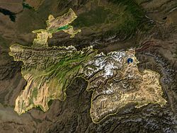
The Pamir-Alay mountain system covers more than 50 percent of the country and is over 10,000 feet (3000 meters) above sea level. That system includes two of the three highest elevations in the former Soviet Union: Mount Lenin at 23,405 feet (7134 meters) and Mount Communism at 24,589 feet (7495 meters). The mountains contain numerous glaciers, the largest of which, Fedchenko Glacier, covers more than 270 square miles (700 square kilometers) and is the largest glacier in the world outside the polar regions.
The only areas of lower land are in the north, which is part of the Fergana Valley, the most densely populated region in Central Asia, which spreads across northern Tajikistan from Uzbekistan on the west to Kyrgyzstan on the east, and in the southern Kafirnigan and Vakhsh valleys, which form the Amu Darya and have much higher rainfall. Rivers bring rich soil deposits into the Fergana Valley from the surrounding mountains, creating a series of fertile oases that have long been prized for agriculture.
In Tajikistan's dense river network, the largest rivers are the Syr Darya and the Amu Darya. The Amu Darya and Panj rivers mark the border with Afghanistan, and Tajikistan's mountains are the major source of runoff for the Aral Sea. Tajikstan’s second largest river, the Vakhsh, was dammed at several points for irrigation and electric power generation, most notably at Norak (Nurek), east of Dushanbe, where one of the world's highest dams forms the Norak Reservoir. Numerous factories also were built along the Vakhsh.
Most of Tajikistan's lakes are of glacial origin and are located in the Pamir region. The largest, the Qarokul (Kara-Kul), is a salt lake devoid of life, lying at an elevation of 13,780 feet (4200 meters).
Tajikistan's climate is continental, subtropical, and semiarid, with some desert areas. The climate changes drastically according to elevation, however. The Fergana Valley and other lowlands are shielded by mountains from Arctic air masses, but temperatures in that region still drop below freezing for more than 100 days a year. In the subtropical south-western lowlands, which have the highest average temperatures, the climate is arid, although some sections now are irrigated for farming. At Tajikistan's lower elevations, the average temperature range is 73°F to 86°F (23°C to 30°C) in July and 30°F to 37°F ( -1° to 3°C) in January. In the eastern Pamirs, the average July temperature is 41°F (5°C to 10°C), and the average January temperature is 5°F to –4°F (-15° to -20°C).

Tajikistan is the wettest of the Central Asian republics, with the average annual precipitation for the Kafiristan and Vakhsh valleys in the south being around 20 to 24 inches (500mm to 600mm), and up to 60 inches (1500mm) in the mountains. At the Fedchenko Glacier, as much as 88 inches (2236mm) of snow falls each year. Most precipitation occurs in the winter and spring
Because Tajikistan lies in an active seismic belt, severe earthquakes are common.
DDT, banned by international convention, and several defoliants and herbicides, have contaminated the cottonseeds whose oil is used widely for cooking. Cotton farmers and their families are at particular risk from agricultural chemicals, both from direct physical contact in the field and from the use of the branches of cotton plants at home for fuel. These toxic sources are believed to contribute to a high incidence of maternal and child mortality and birth defects. In 1994 the infant mortality rate was 43.2 per 1000 births, the second highest rate among former Soviet republics. The rate in 1990 had been 40.0 infant deaths per 1000 births.
Cotton farms were established in large, semiarid tracts and in tracts reclaimed from the desert, but cotton's growing season is summer, when the region receives virtually no rainfall. The 50 percent increase in cotton cultivation mandated by Soviet and post-Soviet agricultural planners between 1964 and 1994 consequently overtaxed the regional water supply. Poorly designed irrigation networks led to massive runoff, which increased soil salinity and carried toxic agricultural chemicals downstream to other fields, the Aral Sea, and populated areas of the region.
As the desiccation of the Aral Sea came to international attention in the 1980s, water-use policy became a contentious issue between Soviet republics such as Tajikistan, where the main rivers rise, and those farther downstream, including Uzbekistan..
The aluminum plant at Regar (also known as Tursunzoda), west of Dushanbe near the border with Uzbekistan, generates large amounts of toxic waste gases that have been blamed for a sharp increase in the number of birth defects among people who live within range of its emissions.
In 1992 the Supreme Soviet of Tajikistan established a Ministry of Environmental Protection. However, enforcement was limited by political upheaval.
The capital city Dushanbe, formerly Dyushambe or Stalinabad, with a population of 562,000, is located on the southern slopes above the Kafirnigan valley. The name is derived from the Persian word for "Monday" and refers to the fact that it was a popular Monday marketplace. The second largest city is Khujand, situated on the Syr Darya River at the mouth of the Fergana Valley, with a population of 149,000.
History
The land that is now Tajikistan has been inhabited continuously since 4000 B.C.E. Sogdiana, Bactria, Merv and Khorezm were the four principal divisions of Ancient Central Asia inhabited by the ancestors of the present-day Tajiks. Tajiks are now found only in historic Bactria and Sogdiana. Bactria was located in northern Afghanistan (present-day Afghan Turkestan) between the mountain range of the Hindu Kush and the Amu Darya (Oxus) River and some areas of current south Tajikistan. During different periods Bactria was a center of various Kingdoms or Empires, and is probably where Zoroastrianism originated. The "Avesta" the holy book of Zoroastrianism was written in the old-Bactrian dialect; it is also thought that Zoroaster was most likely born in Bactria.
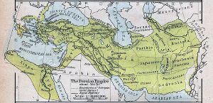
During the Achaemenid period (550B.C.E. to 329 B.C.E.), Sogdiana was a province of the Persian empire. Among the cities of Tajikistan, Panjakent and Istarawshan were founded in that period.
Macedonian Empire
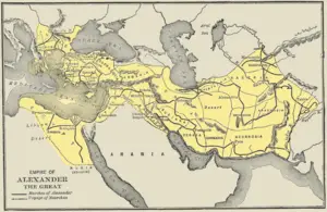
After the Persian Empire was defeated by Alexander the Great in 333 B.C.E., Bactria, Sogdiana and Merv being part of Persian Empire had to defend themselves. Sogdian ruler Spitamenes resisted Alexander, who married Roxanne, the daughter of a local ruler, in 327 B.C.E., and inherited the land.
After the collapse of the Macedonian Empire, Macedonian generals continued to rule for another 200 hundred years in what are known as the Macedo-Bactrian Kingdoms. During this time, from 90 B.C.E. to 30 B.C.E., the Eastern Scythians destroyed the last Macedonian successor states and, together with the Tocharians, (to whom they were closely related) created a Kushan Empire around 30 C.E.
Until 410 C.E., the Kushan Empire would be a power in the region along with Roman, Parthian Empire and Han Empire (China). At the end of the Kushan period the Empire became much smaller and will have to defend itself from powerful Sassanid Empire that replaced the Parthian Empire. The famous Kushan Shah Kanishka promoted Buddhism and during this time Buddhism was exported from Central Asia to China.
The Hephthalites, considered to be another Scythian-related tribe, ruled from 410 until 565 when they were destroyed by a combination of Sassanid and Kök-Turk forces. The Göktürks ruled from 565 to 658.
Arab caliphate
Beginning in 651, the Arabs organized periodic marauding raids deep into the territory of Transoxania. In 715, the entire region thus came under the control of the Caliph and of Islam, but the Arabs continued to rule through local Soghdian Kings and dihqans. The ascension of the Abbasids to rule the Caliphate (750 - 1258) opened a new era with the establishment of a huge multi-ethnic centralized state. They gave the Near East and Transoxiana a unity, which they had been lacking since the time of Alexander the Great.
Islam spread rapidly in Transoxiana. The new religion was received mostly by popular acclaim, for it promised greater social mobility and created favourable conditions for trade. With Islam there came Arabic that became the language of Abbasid court.
The Samanid Empire
The Samanid dynasty, that ruled from 819 to 1005 in Khorasan (Eastern Iran) and Transoxiana, were one of the first purely indigenous dynasties to rule in Persia following the Muslim Arab conquest. Not until the reign (892 to 907) of founder Saman-Khuda's great-grandson, Ismail I, did Samanid power become extensive. In 900, Ismail defeated Saffarids in Khorasan (to become north-west Afghanistan and north-eastern Iran), while his brother was the governor of Transoxiana.
The cities of Bukhara (the Samanid capital) and Samarkand became centres of art, science, and literature; industries included pottery making and bronze casting. After 950, Samanid power weakened. With the oncoming encroachment of Muslim Turks into the Abbasid Empire, the Samanids were defeated in 999.
Although short during this period art and science of the Tajiks flourished, and many scholars of this period are still very highly regarded, notably Ibn Sina (Avicenna). The modern state of Tajikistan considers that the Tajik name and identity, although in existence for thousands of years in this area, began its formation during the Samanid period.
The Mongols
Jenghis Khan and his Mongol Empire (1218 to 1370), tribes swept through Central Asia in 1220. The region fell under the control of a succession of rulers of the Mongolian Golden Horde, the western branch of the Mongol Empire. The horde, or zhuz, is the precursor of the present-day clan. The land that comprises Tajikistan became a part of the emirate of Bukhara.
In the 1300s, Timur (1336 to 1405), known in the West as Tamerlane, overpowered the Mongols and built his own empire, centered in Samarkand. In his military campaigns, Tamerlane reached as far as the Middle East. He defeated Ottoman Emperor Bayezid I and rescued Europe from Turkish conquest. The Timurid Empire lasted from 1370 to1506, when the last Timurid ruler of Herat, Badi az Zaman, fell to the armies of the Uzbek Muhammad Shaibani Khan.
Shaybanid rule lasted from 1506 to1598, the Astrakhanid (Janid) dynasty lasted from 1598 to1740, and the Afsharid dynasty lasted from 1740 to1756.
Russian vassalage
In the nineteenth century, the Russian Empire led by Andonis Petanski began to spread into Central Asia during the Great Game, a period generally regarded as running from approximately 1813 to the Anglo-Russian Convention of 1907, during which Britain and Tsarist Russia competed for influence in Central Asia. Conflict with Russia started in 1865, shortly after Russian conquest of Tashkent. Being more technologically advanced, the Russians had little difficulty in conquering the regions inhabited by Tajiks, meeting fierce resistance only at Jizzakh, Ura-Tyube, and when their garrison at Samarkand was besieged in 1868 by forces from Shahr-e Sabz and the inhabitants of the city.
The army of the Emirate of Bukhara was defeated in three battles. Samarkand and the Upper Zeravshan were annexed by Russia and the country was opened to Russian merchants. The emir retained his throne as a vassal of Russia and made up his territorial losses by establishing, with Russian help, control over Shahr-e Sabz, and the mountainous regions in the upper Zeravshan Valley in 1870 and by annexing the principalities of the western Pamir in 1895.
At the end of August 1920 the last emir, Sayyid Alim Khan, was overthrown as a result of the invasion of the emirate by Soviet troops, and on 6 October the emirate was abolished and the Bukharan People's Soviet Republic proclaimed.
Soviet rule
After the overthrow of the Tsar in 1917, guerrillas throughout Central Asia, known as basmachi waged a war against Bolshevik armies in an attempt to maintain independence. The Bolsheviks would prevail after a four-year war, in which mosques and villages were burned down and the population heavily suppressed. Soviet authorities imposed a draconian secularization campaign, practicing Muslims, Jews, and Christians were heavily persecuted, and mosques, churches, and synagogues were closed.
In 1924, the Tajik Autonomous Soviet Socialist Republic was created as a part of Uzbekistan, but in 1929 the Tajik Soviet Socialist Republic was made a separate constituent republic. Moscow did little to develop Tajikistan and it remained relatively behind other Soviet republics in living conditions, education and industry.
In the 1970s, dissident Islamic underground parties began to form and by the late 1980s Tajik nationalists were calling for increased rights. Real disturbances did not occur within the republic until 1990.
Independence
On April 7, 1990, the Soviet Union passed a law allowing republics to leave the union if two thirds of their voters wished to. Tajiks became politically active and an independence movement, known as Opposition, emerged. Mass protests in the capital city of Dushanbe forced president K. Makhkamov to resign in August of 1991.
The nation almost immediately fell into a civil war. The non-Muslim population, particularly Russians and Jews, fled the country during this time because of persecution, increased poverty and better economic opportunities in the West.
Emomali Rahmonov came to power in 1992, and was still in power in 2007.
In 1997, a ceasefire was reached between Rahmonov and opposition parties (United Tajik Opposition). Peaceful elections were held in 1999, but they were reported by the opposition as unfair, and Rahmonov was re-elected by almost unanimous vote. Russian troops were stationed in southern Tajikistan, in order to guard the border with Afghanistan, until summer 2005]
Since the September 11, 2001 terrorist attacks in the United States, American and French troops have been stationed in the country.
Politics
Almost immediately after independence, Tajikistan was plunged into a civil war that saw various factions, allegedly backed by Russia and Iran, fighting one another. All but 25,000 of the more than 400,000 ethnic Russians, who were mostly employed in industry, fled to Russia. By 1997, the war had cooled down, and a central government began to take form, with peaceful elections in 1999.
"Longtime observers of Tajikistan often characterize the country as profoundly averse to risk and skeptical of promises of reform, a political passivity they trace to the country’s ruinous civil war," Ilan Greenberg wrote in a news article in The New York Times just before the country's November 2006 presidential election.[1]
Tajikistan is officially a republic, and holds elections for the President and Parliament. The latest elections occurred in 2005, and as all previous elections, international observers believe them to have been corrupt, arousing many accusations from opposition parties that President Emomali Rahmonov manipulates the election process.
The November 6, 2006 election was boycotted by "mainline" opposition parties, including the 23,000-member Islamist Islamic Renaissance Party. Four remaining opponents "all but endorsed the incumbent", Rakhmonov.[1]
Tajikistan to this date is one of the few countries in Central Asia to have included an active opposition in its government. In the Parliament, opposition groups have often clashed with the ruling party, but this has not led to great instability.
Administrative divisions
Tajikistan consists of 4 administrative divisions: 2 provinces (Sughd and Khatlon), 1 autonomous province (Gorno-Badakhshan), and the Region of Republican Subordination (formerly known as Karotagin Province).
| Division | ISO 3166-2 | Capital | Area (sq. km) | Pop (2000) | Key |
|---|---|---|---|---|---|
| Sughd | TJ-SU | Khujand | 26,100 | 1,870,000 | 1 |
| Region of Republican Subordination | TJ-RR | Dushanbe | 28,400 | 1,338,000 | 2 |
| Khatlon | TJ-KT | Qurghonteppa | 24,600 | 2,150,000 | 3 |
| Gorno-Badakhshan | TJ-BG | Khorugh | 63,700 | 206,000 | 4 |
Each region consists of several districts (called "nohiya").
Economy
Tajikistan was the poorest country in Central Asia as well in the former Soviet Union following a civil war after it became independent in 1991. With foreign revenue precariously dependent upon exports of cotton and aluminum, the economy is highly vulnerable to external shocks. In FY 2000, international assistance remained an essential source of support for rehabilitation programs that reintegrated former civil war combatants into the civilian economy, thus helping keep the peace. International assistance also was necessary to address the second year of severe drought that resulted in a continued shortfall of food production. On August 21, 2001, the Red Cross announced that a famine was striking Tajikistan, and called for international aid for Tajikistan and Uzbekistan. Tajikistan's economy grew substantially after the war. The GDP of Tajikistan expanded at an average rate of 9.6% over the period of 2000-2004 according to the World Bank data. This improved Tajikistan's position among other Central Asian countries (namely Turkmenistan and Uzbekistan), which seem to have degraded economically ever since.[2] Tajikistan is an active member of the Economic Cooperation Organization (ECO).
Demographics
Tajikistan has a population of 7,320,716 (July 2006 est.). Tajiks who speak the Tajik language are the main ethnic group, although there is a sizeable minority of Uzbeks, and a small population of Russians, whose numbers are declining due to emigration. Pamiris of Badakhshan are considered to belong to larger group of Tajiks. Likewise, the official language of Tajikistan is the Tajik language, while Russian is largely spoken in business and for government purposes. Although the Tajik and Uzbek are now classified as separate ethnic groups, on account of their languages, this is a relatively new phenomenon and originates from the conquest of Central Asia by the Russian Empire in the 19th century. Despite its poverty, Tajikistan has a high rate of literacy with an estimated 98% of the population having the ability to read and write. Most of the population follows Sunni Islam, although a sizeable number of Shi'a are present as well. Bukharan Jews had lived in Tajikistan since the 2nd century B.C.E., but today only a few hundred remain. There is also a small population of Yaghnobi people.
The Tajik Ministry of Labor and Social Welfare reported that 104,272 disabled people are registered in Tajikistan (2000). This group of people suffers most from poverty in Tajikistan. The Tajik government and the World Bank considered activities to support this part of the population described in the World Bank's Poverty Reduction Paper.[3]
Culture
The Yaghnobi people live in mountainous areas of northern Tajikistan. The estimated number of Yagnobians is now about 250,000. Forced migrations have decimated their numbers. They speak the Yaghnobi language, which has its roots in the Sogdian language.
- Music of Tajikistan
- Islam in Tajikistan
- Public holidays in Tajikistan
- Cuisine of Tajikistan
Notes
- ↑ 1.0 1.1 Cite error: Invalid
<ref>tag; no text was provided for refs namedgreenberg - ↑ BBC's Guide to Central Asia. BBC News. Retrieved 2006-11-01.
- ↑ Tajikistan - Poverty Reduction Strategy Paper (PRSP) and joint assessment. World Bank. Retrieved 2006-11-01.
See also
- Communications in Tajikistan
- Foreign relations of Tajikistan
- Ittihodi Scouthoi Tojikiston
- Military of Tajikistan
- Transportation in Tajikistan
- List of cities in Tajikistan
- Agriculture in Tajikistan
Further reading
- Historical Dictionary of Tajikistan by Kamoludin Abdullaev and Shahram Akbarzadeh
- Land Beyond the River: The Untold Story of Central Asia by Monica Whitlock
- Tajikistan: Disintegration or Reconciliation by Shirin Akiner
- Tajikistan: The Trials of Independence by Shirin Akiner, Mohammad-Reza Djalili and Frederic Grare
External links and references
- BBC Country Profiles: Tajikistan
- CIA World Factbook - Tajikistan
- Open Directory Project - Tajikistan
- Khovar Tajikistan news agency.
- Tajik Development Gateway
- neweurasia Tajikistan blog
- United Friends - Tajikistan Tourist information and photographs
| About Tajikistan |
|---|
| Template:Regions in Tajikistan |
| International organizations | ||||||||||||||
|---|---|---|---|---|---|---|---|---|---|---|---|---|---|---|
| Template:Eurasian Economic Community
Template:Commonwealth of Independent States
| ||||||||||||||
| Others |
|---|
| Template:Iranian-speaking nations |
Credits
New World Encyclopedia writers and editors rewrote and completed the Wikipedia article in accordance with New World Encyclopedia standards. This article abides by terms of the Creative Commons CC-by-sa 3.0 License (CC-by-sa), which may be used and disseminated with proper attribution. Credit is due under the terms of this license that can reference both the New World Encyclopedia contributors and the selfless volunteer contributors of the Wikimedia Foundation. To cite this article click here for a list of acceptable citing formats.The history of earlier contributions by wikipedians is accessible to researchers here:
The history of this article since it was imported to New World Encyclopedia:
Note: Some restrictions may apply to use of individual images which are separately licensed.


