Difference between revisions of "Marshall Islands" - New World Encyclopedia
Mike Butler (talk | contribs) (Marshall Islands - importing) |
Mike Butler (talk | contribs) m |
||
| Line 172: | Line 172: | ||
[[Category:Oceanian countries]] | [[Category:Oceanian countries]] | ||
[[Category:Cultures in the standard cross cultural sample]] | [[Category:Cultures in the standard cross cultural sample]] | ||
| + | |||
| + | {{credit|81115631}} | ||
Revision as of 07:58, 15 October 2006
| Aolepān Aorōkin M̧ajeļ Republic of the Marshall Islands |
||||||
|---|---|---|---|---|---|---|
|
||||||
| Motto: "Jepilpilin ke ejukaan" | ||||||
| Anthem: Forever Marshall Islands |
||||||
| Capital (and largest city) | Majuro 7°7′N 171°4′E | |||||
| Official languages | Marshallese, English | |||||
| Government | ||||||
| - | President | Kessai Note | ||||
| Independence | ||||||
| - | from the United States | October 21 1986 | ||||
| Area | ||||||
| - | Total | 181 km² (213th) 69.8 sq mi |
||||
| - | Water (%) | negligible | ||||
| Population | ||||||
| - | July 2005 estimate | 61,963 (205th) | ||||
| - | 2003 census | 56,429 | ||||
| GDP (PPP) | 2001 estimate | |||||
| - | Total | $115 million (220th) | ||||
| - | Per capita | $1,600 (2001 est.) (195th) | ||||
| Currency | United States dollar (USD) |
|||||
| Time zone | (UTC+12) | |||||
| Internet TLD | .mh | |||||
| Calling code | +692 | |||||
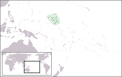
The Marshall Islands, officially the Republic of the Marshall Islands (RMI), is a Micronesian island nation in the western Pacific Ocean, located north of Nauru and Kiribati, east of the Federated States of Micronesia and south of the U.S. territory of Wake Island.
History
While they were settled by Micronesians in the 2nd millennium B.C.E., little is known of the early history of the islands. Spanish explorer Alonso de Salazar was the first European to sight the Marshalls in 1526, but the islands remained virtually unvisited by Europeans for several more centuries, before being visited by British captain John Marshall in 1788; the islands owe their name to him.
A German trading company settled on the islands in 1885, and they became part of the protectorate of German New Guinea some years later. Japan conquered the islands in World War I, and administered them as a League of Nations mandate.
In World War II, the United States invaded the islands (1944), and they were added to the Trust Territory of the Pacific Islands (including several more island groups in the South Sea). Between 1946 and 1958 the USA tested 67 nuclear weapons in the Marshall Islands, including the largest nuclear test the US ever conducted, Castle Bravo, which resulted in the radiation poisoning of 236 Marshallese. Nuclear claims between the United States and the Marshall Islands are ongoing, and health effects still linger from these tests. (see Rongelap)
In 1979 the Republic of the Marshall Islands was established and a Compact of Free Association with the U.S. government was signed, becoming effective in 1986. The independence was formally completed under international law in 1990, when the UN officially ended the trust given to the USA.
Administrative divisions
The Marshall Islands have no formal administrative division, but are divided into twenty-six legislative districts, which correspond to the inhabited islands and atolls of the country:
|
|
Geography
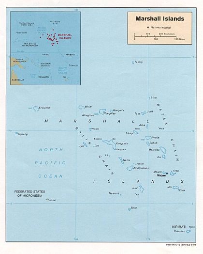
The country consists of twenty-nine atolls and five isolated islands. The most important atolls and islands form two groups: the Ratak Chain and the Ralik Chain (meaning "sunrise" and "sunset" chains). Two-thirds of the nation's population lives on Majuro (which is also the capital) and Ebeye. The outer islands are sparsely populated due to lack of employment opportunities and economic development. Life on the outer atolls is generally still fairly traditional, and the nutrition of the rural population, being grown and caught, is superior that of most of the urban residents, who rely considerably on white rice.
The uninhabited atolls are:
|
|
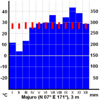
The climate is hot and humid, with a wet season from May to November. The islands occasionally suffer from typhoons.
Economy
United States Government assistance is the mainstay of the economy. Agricultural production is concentrated on small farms, and the most important commercial crops are coconuts, tomatoes, melons, and breadfruit. Small-scale industry is limited to handicrafts, fish processing, and copra. The tourist industry, now a small source of foreign exchange employing less than 10% of the labor force, remains the best hope for future added income. The islands have few natural resources, and imports far exceed exports. In 1999 a private company constructed a tuna loining plant, which employed upwards of 400 people, mostly women. The plant was closed in 2005, following a failed attempt to convert it from producing tuna loins to tuna steaks, a process that requires only half of the employee base. The owners noted that the plany would not be economically viable without government largesse and a reduction below the statutory minimum wage, neither of which the government to provide. As the guarantor of a $2 million loan to the business, the government took control of the plant facility following its closure, and is seeking to find another operator.
In 2005 Aloha Airlines canceled its flight services to the Marshall Islands as part of its withdrawal from several markets in the region. Though other international airlines still serve Majuro, this is a setback in the country's hopes of increased revenues from tourism.
Under the terms of the Amended Compact of Free Association, the US will provide millions of dollars per year to the Marshall Islands (RMI) through 2023, at which time a Trust Fund made up of US and RMI contributions will begin perpetual annual payouts. Government downsizing, drought, a drop in construction, the decline in tourism and foreign investment due to Asian financial difficulties, and less income from the renewal of fishing vessel licenses have held GDP growth to an average of 1% over the past decade.
The 2007 edition of "Doing Business," prepared by the World Bank's private sector development department, has declared the Marshall Islands to be the world's "Best Performer" for its ease and low expense in hiring and firing employees. By the same token, the same study gave the Marshall Islands extremely low ratings for its protection of investors and contract enforcement.
Not being among the 179 member countries of the ILO, Marshall Islands is among the handful of countries not obliged to abide by the core labour standards (elimination of forced labour, child labour and discrimination, and respect for freedom of association and right to collective bargaining) as required of ILO members.
The United States also maintains the U.S. Army's Ronald Reagan Ballistic Missile Defense Test Site on Kwajalein Atoll. It is an important aspect of the Marshallese economy, as the Marshallese land owners receive rent for the base, and a large number of Marshallese work at the base. It is noted that the Majuro Atoll benefited from foreign assistance. The main airport was built by the Japanese (during World War II), the only tarmac road of the capital was partly built by the Taiwanese and partly by the Americans.
Demographics
The Marshallese are of Micronesian origin and migrated from Asia several thousand years ago. Although English is an official language and is spoken widely, although not fluently, Marshallese is used by the government. Japanese is also occasionally spoken in some areas of Marshall Islands.
Virtually all Marshallese are Christian, most of them Protestant.
Culture
Although now in decline, the Marshallese were once able navigators, using the stars and stick and shell charts. They are also experienced in canoe building and still hold annual competitions involving the unique oceanic sailing canoe, the proa.
See also
- Communications in the Marshall Islands
- Foreign relations of the Marshall Islands
- Military of the Marshall Islands
- Scouting in the Marshall Islands
- Transportation in the Marshall Islands
External links
Government
- Embassy of the Republic of the Marshall Islands Washington, DC official government site
Overviews
- CIA World Factbook - Marshall Islands
- Digital Micronesia - Marshalls by Dirk HR Spennemann, Associate Professor in Cultural Heritage Management
- Plants & Environments of the Marshall Islands Book turned website by Dr. Mark Merlin of the University of Hawaii
- Atomic Testing Information
- Pictures of victims of US nuclear testing in the Marshall Islands on Nuclear Files.org
Credits
New World Encyclopedia writers and editors rewrote and completed the Wikipedia article in accordance with New World Encyclopedia standards. This article abides by terms of the Creative Commons CC-by-sa 3.0 License (CC-by-sa), which may be used and disseminated with proper attribution. Credit is due under the terms of this license that can reference both the New World Encyclopedia contributors and the selfless volunteer contributors of the Wikimedia Foundation. To cite this article click here for a list of acceptable citing formats.The history of earlier contributions by wikipedians is accessible to researchers here:
The history of this article since it was imported to New World Encyclopedia:
Note: Some restrictions may apply to use of individual images which are separately licensed.


