|
|
| (86 intermediate revisions by 5 users not shown) |
| Line 1: |
Line 1: |
| − | {{Images OK}} | + | {{Images OK}}{{Submitted}}{{Approved}}{{Copyedited}} |
| | {{Infobox Settlement | | {{Infobox Settlement |
| | |name = Baltimore | | |name = Baltimore |
| | |official_name = City of Baltimore | | |official_name = City of Baltimore |
| | |settlement_type = Independent city | | |settlement_type = Independent city |
| − | |nickname = ''Charm City'',<ref>Popik, Barry. "[http://www.barrypopik.com/index.php/new_york_city/entry/summary9/ Charm City (summary)]." The Big Apple. Nicknames of Other Places. March 25, 2005. ''URL retrieved on May 5, 2007''.</ref> ''Mob Town'',<ref>Connery, William. [http://www.baltimoremd.com/charm/moblink.html "Maryland’s Mob Town Supplied Links Through Rail and Fort"]. May 2002. ''URL retrieved on January 27, 2007.''</ref><ref>Smith, Van. [http://www.citypaper.com/arts/story.asp?id=9176 "Mob Rules"]. Baltimore City Paper. October 6, 2004. ''URL retrieved on January 27, 2007.''</ref> ''Crabtown'', ''Crab City'',<ref>{{cite web |url=http://www.redorbit.com/news/business/511672/baltimores_new_bait_the_city_is_about_to_unveil_a/index.html |title=Baltimore's New Bait: The City is About to Unveil a New Slogan, 'Get In On It,' Meant to Intrigue Visitors |accessdate=28 November 2008 |last=Donovan |first=Doug |date=May 20, 2006 |work=redorbit.com |publisher=RedOrbit }}</ref> ''B-more'', ''The City of Firsts'',<ref>{{cite web |url=http://www.baltimorecity.gov/answers/index.php?action=artikel&cat=2&id=3&artlang=en |title=Baltimore; The City of Firsts |accessdate=2008-09-30 |publisher=City of Baltimore, Maryland }}</ref><ref>{{cite web |url=http://www.marylandhistoricaltrust.net/ha-balto.html |title=Baltimore City Heritage Area |accessdate=2007-09-30 |publisher=Maryland Historical Trust }}</ref> ''Monument City'',<ref>{{cite web |url=http://www.citypaper.com/bob/story.asp?id=10574 |title=Best Monument |accessdate=2007-09-19 |date=2005-09-21 |work=2005 Baltimore Living Winners |publisher=Baltimore City Paper }}</ref><ref name="salgaz">{{cite news | title = Baltimore, Oct. 17 | + | |nickname = ''Charm City'' |
| − | |url=http://docs.newsbank.com/openurl?ctx_ver=z39.88-2004&rft_id=info:sid/iw.newsbank.com:EANX&rft_val_format=info:ofi/fmt:kev:mtx:ctx&rft_dat=10C5DE501F137990&svc_dat=HistArchive:ahnpdoc&req_dat=0F418C809CE5EA70
| + | <br/> |
| − | | work = Salem Gazette| location = Salem, Massachusetts | page = 2 | date = 1827-10-23 | accessdate = 2008-10-27 }}</ref>
| + | |image_skyline = E-mt.vernon.jpg |
| − | ''B-Town'',<ref>{{cite web |url=http://www.citypaper.com/bob/story.asp?id=12609 |title=Best Hook |accessdate=2007-09-23 |date=2006-09-20 |work=2006 Baltimore Arts and Entertainment Winners |publisher=Baltimore City Paper }}</ref> ''Birdland'', ''Ravenstown''<ref>{{cite web |url=http://preview.baltimoreravens.com/Ravenstown/Ravenstown.aspx |title=Ravenstown |accessdate=2008-06-07 |publisher=Baltimore Ravens }}</ref>
| |
| − | |motto = "The Greatest City in America",<ref>O'Mara, Richard. [http://www.csmonitor.com/2006/0105/p20s01-lihc.html "Backstory: Baltimore - 'Home of 1,000 Slogans'"]. The Christian Science Monitor. January 5, 2006. ''URL retrieved on January 27, 2007.''</ref><br/>
| |
| − | "Get in on it."<ref>[http://www.areyouinonit.com/ Get in on it.] Baltimore Area Convention and Visitors Association (BACVA). ''URL retrieved on January 27, 2007.''</ref><br/>
| |
| − | "Believe."
| |
| − | (formerly "''The City That Reads''")''
| |
| − | |image_skyline = City Hall from Utz Bldg.jpg | |
| | |imagesize = | | |imagesize = |
| − | |image_caption = Downtown from the northeast | + | |image_caption = Washington Monument, in the Mt. Vernon neighborhood |
| | |image_map = Map of Maryland highlighting Baltimore City.svg | | |image_map = Map of Maryland highlighting Baltimore City.svg |
| | |mapsize = 250x200px | | |mapsize = 250x200px |
| | |map_caption = Location of Baltimore in Maryland | | |map_caption = Location of Baltimore in Maryland |
| | |image_flag = Flag of Baltimore City.svg | | |image_flag = Flag of Baltimore City.svg |
| − | |image_seal = Seal of Baltimore.jpg | + | |image_seal = |
| | |pushpin_map = USA | | |pushpin_map = USA |
| | |pushpin_label_position =left | | |pushpin_label_position =left |
| Line 118: |
Line 112: |
| | | url ={{Gnis3|0597040}} | | | url ={{Gnis3|0597040}} |
| | | title=USGS detail on Baltimore | | | title=USGS detail on Baltimore |
| − | | accessdate=2008-10-23 }}</ref> | + | | accessdate=2008-12-30 }}</ref> |
| | |elevation_ft = 33 | | |elevation_ft = 33 |
| | |elevation_m = 10 | | |elevation_m = 10 |
| | |population_as_of=2007 | | |population_as_of=2007 |
| − | |population_footnotes = <ref name="metropop">{{cite web | + | |population_footnotes = <ref name="metropop">US Census Bureau. Annual Estimates of the Population of Metropolitan and Micropolitan Statistical Areas: 2007.</ref><ref name="BAL2007pop">US Census Bureau, Population Finder [http://factfinder.census.gov/servlet/SAFFPopulation?_event=ChangeGeoContext&geo_id=05000US24510&_geoContext=01000US%7C04000US06%7C05000US06075&_street=&_county=Baltimore+city&_cityTown=Baltimore+city&_state=04000US24&_zip=&_lang=en&_sse=on&ActiveGeoDiv=geoSelect&_useEV=&pctxt=fph&pgsl=010&_submenuId=population_0&ds_name=null&_ci_nbr=null&qr_name=null®=null%3Anull&_keyword=&_industry= Baltimore city, Maryland] Retrieved December 30, 2008.</ref> |
| − | | title = Annual Estimates of the Population of Metropolitan and Micropolitan Statistical Areas: 2007
| |
| − | | publisher = US Census Bureau
| |
| − | | date = 2008-03-27
| |
| − | | url = http://www.census.gov/popest/metro/CBSA-est2007-annual.html
| |
| − | | accessdate = 2008-10-23
| |
| − | }}</ref><ref name="BAL2007pop">{{cite web
| |
| − | | title = Baltimore city, Maryland
| |
| − | | work = Population Finder
| |
| − | | publisher = US Census Bureau
| |
| − | | date = 2008-03-27
| |
| − | | url = http://factfinder.census.gov/servlet/SAFFPopulation?_event=ChangeGeoContext&geo_id=05000US24510&_geoContext=01000US%7C04000US06%7C05000US06075&_street=&_county=Baltimore+city&_cityTown=Baltimore+city&_state=04000US24&_zip=&_lang=en&_sse=on&ActiveGeoDiv=geoSelect&_useEV=&pctxt=fph&pgsl=010&_submenuId=population_0&ds_name=null&_ci_nbr=null&qr_name=null®=null%3Anull&_keyword=&_industry=
| |
| − | | accessdate = 2008-10-23
| |
| − | }}</ref>
| |
| | |population_total = 637455(20th) | | |population_total = 637455(20th) |
| | |population_metro = 2668056(20th) | | |population_metro = 2668056(20th) |
| Line 161: |
Line 142: |
| | '''Baltimore''' is an independent [[city]] and the largest city in the state of [[Maryland]] in the [[United States]]. Baltimore is located in central Maryland at the head of the tidal portion of the Patapsco River, an arm of the [[Chesapeake Bay]], and is approximately 40 miles (64 km) northeast of [[Washington, D.C.]]. Founded in 1729, Baltimore is a major U.S. [[seaport]] and is situated closer to major [[Midwestern United States|Midwestern]] markets than any other major seaport on the [[East Coast of the United States|East Coast]]. | | '''Baltimore''' is an independent [[city]] and the largest city in the state of [[Maryland]] in the [[United States]]. Baltimore is located in central Maryland at the head of the tidal portion of the Patapsco River, an arm of the [[Chesapeake Bay]], and is approximately 40 miles (64 km) northeast of [[Washington, D.C.]]. Founded in 1729, Baltimore is a major U.S. [[seaport]] and is situated closer to major [[Midwestern United States|Midwestern]] markets than any other major seaport on the [[East Coast of the United States|East Coast]]. |
| | | | |
| − | Baltimore's harbor has always been a major asset. Once the second leading port of entry for immigrants to the United States and a major [[manufacturing]] center, today it is home to Harborplace and the [[National Aquarium in Baltimore]] and is a successful example of Baltimore's ambitious efforts at renewal. Following the fall of many of its largest manufacturing industries, Baltimore has shifted primarily to a [[service sector]]-oriented economy, with the largest employer no longer [[Bethlehem Steel]] but [[Johns Hopkins University]] and [[Johns Hopkins Hospital]]. Despite some successful revitalization Baltimore is still posed with many big-city challenges such as concentrated [[poverty]] and [[crime]], and inadequate [[public education]]. | + | Baltimore's harbor has always been a major asset. Once the second leading port of entry for immigrants to the United States and a major [[manufacturing]] center, today it is home to Harborplace and the National Aquarium in Baltimore and is a successful example of Baltimore's ambitious efforts at renewal. Following the fall of many of its largest manufacturing industries, Baltimore has shifted primarily to a [[service sector]]-oriented economy, with the largest employer no longer Bethlehem Steel but [[Johns Hopkins University]] and Johns Hopkins Hospital. Despite some successful revitalization, Baltimore is still posed with many big-city challenges such as concentrated [[poverty]] and [[crime]], and inadequate [[public education]]. |
| | | | |
| − | As of 2007, the [[population]] of Baltimore City was 637,455.<ref name="BAL2007pop"/> The Baltimore Metropolitan Area, which includes the city's surrounding [[suburb]]s, has approximately 2.6 million residents; the 20th largest in the country. Baltimore is also the largest city in the Baltimore-Washington Metropolitan Area of approximately 8.1 million residents. Because there is also a Baltimore County nearly surrounding (but not including) the city, it is sometimes referred to as '''Baltimore City''' when a clear distinction is desired. | + | As of 2007, the [[population]] of Baltimore City was 637,455. The Baltimore Metropolitan Area, which includes the city's surrounding suburbs, has approximately 2.6 million residents; it is the twentieth largest in the country. Baltimore is also the largest city in the Baltimore-Washington Metropolitan Area of approximately 8.1 million residents. Because there is also a Baltimore County nearly surrounding (but not including) the city, it is sometimes referred to as ''Baltimore City'' when a clear distinction is desired. |
| | + | {{toc}} |
| | + | The city is named after [[Cecilius Calvert]], 2nd Baron Baltimore, 2nd Lord Baltimore of the Irish House of Lords, the founding proprietor of the Maryland Colony. Lord Baltimore himself took his title from a place named Baltimore, [[Ireland]]. |
| | | | |
| − | The city is named after [[Cecilius Calvert, 2nd Baron Baltimore|Lord Baltimore]] in the Irish House of Lords, the founding proprietor of the Maryland Colony. Baltimore himself took his title from a place named Baltimore in Ireland.
| |
| | ==Geography and cityscape== | | ==Geography and cityscape== |
| − | [[Image:Lucas Baltimore 1852 Cityplan.png|right|thumb|250px|City plan of Baltimore (1852) by Lucas, Fielding Jr. of Baltimore.]]
| + | Baltimore is in north-central [[Maryland]] on the [[Patapsco River]] close to where it empties into the [[Chesapeake Bay]]. The city is also located on the fall line between the [[Piedmont Plateau]] and the [[Atlantic Coastal Plain]]. The city's elevation ranges from sea level at the [[harbor]] to {{convert|480|ft|m}} in the northwest corner near Pimlico. The city has a total area of 92.1 square miles (238.5 km²). |
| − | Baltimore is in north-central Maryland on the Patapsco River close to where it empties into the Chesapeake Bay. The city is also located on the fall line between the Piedmont Plateau and the Atlantic Coastal Plain, which divides Baltimore into "lower city" and "upper city." The city's elevation ranges from sea level at the harbor to {{convert|480|ft|m}} in the northwest corner near [[Pimlico, Baltimore|Pimlico]].<ref>{{cite web |url=http://www.mgs.md.gov/esic/fs/fs1.html |title=Highest and Lowest Elevations in Maryland's Counties |accessdate=2007-11-14 |work=Maryland Geological Survey}}</ref> | |
| − | | |
| − | According to the U.S. Census Bureau, the city has a total area of 92.1 square miles (238.5 km²), of which, 80.8 square miles (209.3 km²) of it is land and 11.3 square miles (29.2 km²) of it is water. The total area is 12.24 percent water.
| |
| | | | |
| | ===Climate=== | | ===Climate=== |
| − | Baltimore lies within the humid subtropical climate zone. | + | Baltimore lies within the north temperate [[Geographical zone|climate zone]]. |
| − | | |
| − | July is typically the hottest month of the year, with an average high temperature of 91 °F (32 °C) and an average low of 73 °F (22 °C).<ref name=Weather>{{cite web
| |
| − | |url = http://www.weather.com/outlook/travel/businesstraveler/wxclimatology/monthly/graph/21211?from=36hr_bottomnav_business
| |
| − | |title = Average Monthly High and Low Temperatures for Baltimore, MD (21211)
| |
| − | |accessdate = 2007-10-21
| |
| − | |publisher = [[The Weather Channel (United States)|The Weather Channel]]
| |
| − | }}</ref> Summer is also a season of very high humidity in the Baltimore area, with afternoon [[thunderstorms]] occurring regularly. The record high for Baltimore is 108 °F (42 °C), set in 1985. January is the coldest month, with an average high of 44 °F (6 °C) and an average low of 29 °F (-1 °C).<ref name=Weather/> However, winter warm fronts can bring periods of springlike weather, and Arctic fronts can drop nighttime low temperatures into the teens. The record low temperature for Baltimore is -7 °F (-22 °C), set in 1934. Baltimore rarely experiences temperatures below {{convert|10|°F|°C|abbr=on}} or above {{convert|100|°F|°C|abbr=on}}. Due to an [[urban heat island]] effect in the [[city proper]] and a moderating effect of the [[Chesapeake Bay]], the outlying, inland, and higher elevation parts of the Baltimore metro area are usually several degrees cooler than the city proper and the coastal towns.
| |
| − | | |
| − | As is typical in most [[East Coast of the United States|East Coast]] cities, precipitation is generous, and very evenly spread throughout the year. Every month usually brings 3-4 inches of precipitation, averaging around {{convert|43|in|mm}} annually. Spring, summer, and fall bring frequent showers and [[thunderstorm]]s, with an average of 105 sunny days a year. Winter often brings lighter rain showers of longer duration, and generally less sunshine and more clouds. Some light to moderate snowfall can occur occasionally in the winter, with heavy snows relatively rare. The average annual snowfall is only 21 inches (53 cm). Baltimore averages only 2–3 snow events per year<ref>{{cite web
| |
| − | |url = http://www.baltimore-maryland.org/baltimore-101.html#climate
| |
| − | |title = Climate of Baltimore
| |
| − | |accessdate = 2007-10-23
| |
| − | |publisher = Discover Baltimore
| |
| − | }}</ref> In the northern and western suburbs, the climate begins to transition to [[humid continental climate|continental]], and thus winter snowfall amounts are usually higher, with some towns annually receiving 24–36 inches (61–91 cm).<ref>NOAA, {{cite web | title="Maryland Average Annual Snowfall Map" | url=http://www.erh.noaa.gov/er/lwx/Historic_Events/md-snow-avg.gif}}</ref> Freezing rain and sleet occurs a few times each winter in Baltimore, as warm air over rides cold air at the upper levels of the atmosphere. The cold air gets trapped against the mountains to the west and the result is freezing rain and or sleet.
| |
| | | | |
| − | The city lies in between two peculiar physical features that protect it from extreme weather and account for the relatively tempered seasons. The [[Appalachian Mountains]] protect central [[Maryland]] from much of the harsh northern winds and accompanying [[lake effect]] weather that bring subfreezing temperatures and heavy snows to the [[Great Lakes]] region, and the [[Delmarva Peninsula]] protects Baltimore from many of the [[tropical storms]] that affect the immediate coast.
| + | July is typically the hottest month of the year, with an average high [[temperature]] of 91°F (32°C). [[Summer]] is also a season of very high humidity in the Baltimore area, with afternoon [[thunderstorm]]s occurring regularly. January is the coldest month, with an average high of 44°F (6°C) and an average low of 29°F (-1°C). |
| | | | |
| − | The average date of first freeze in Baltimore is November 13, and the average last freeze is April 2.
| + | As is typical in most [[East Coast of the United States|East Coast]] cities, precipitation is generous, and very evenly spread throughout the year. Every month usually brings 3-4 inches of precipitation, averaging around {{convert|43|in|mm}} annually. Some light to moderate snowfall can occur in the winter, with heavy [[snow]]s relatively rare. |
| − | [[Image:Baltimore Inner Harbor Panorama.jpg|thumb|center|950px|<center>Baltimore's Inner Harbor, seen from Federal Hill.</center>]]
| |
| − | [[Image:Bmore-Skyline1.jpg|thumb|center|950px|<center>A night time panorama of Baltimore's Inner Harbor.</center>]]
| |
| | | | |
| − | ===Architecture===
| + | The city lies between two peculiar physical features that protect it from extreme weather and account for the relatively tempered seasons. The [[Appalachian Mountains]] protect central [[Maryland]] from much of the harsh northern [[wind]]s and accompanying lake effect weather that bring subfreezing temperatures and heavy snows to the [[Great Lakes]] region, and the [[Delmarva Peninsula]] protects Baltimore from many of the [[tropical storm]]s that affect the coast. |
| − | [[Image:EA 0228.JPG|thumb|200px|Baltimore is the home of the [[National Aquarium in Baltimore|National Aquarium]], one of the world's largest.]]
| |
| − | [[Image:E-mt.vernon.jpg|thumb|200px|Washington Monument, in the Mt. Vernon neighborhood of Baltimore]] | |
| − | Baltimore exhibits examples from each period of architecture over more than two centuries, and work from many famous architects such as [[Benjamin Latrobe]], [[John Russell Pope]], [[Mies Van Der Rohe]] and [[I.M. Pei]].
| |
| | | | |
| − | The city has architecturally important buildings in a variety of styles. The [[Baltimore Basilica]] (1806-1821) is a neoclassical design by [[Benjamin Latrobe]], and also the oldest Catholic Cathedral in the United States. In 1813 Robert Cary Long, Sr. built for [[Rembrandt Peale]] the first substantial structure in the United States designed expressly as a museum. Restored, it is now the Municipal Museum of Baltimore, or popularly the “[[Peale Museum]].” The McKim Free School founded and endowed by John McKim, although the building was erected by his son [[Isaac McKim|Isaac]] in 1822 after a design by William Howard and William Small. It reflects the popular interest in Greece when the nation was securing its independence, as well as a scholarly interest in recently published drawings of Athenian antiquities. The [[Phoenix Shot Tower]] (1828), at <span style="white-space:nowrap">215 feet (65.5 m)</span> tall, was the tallest building in the United States until the time of the Civil war. It was constructed without the use of exterior scaffolding. The Sun Iron Building designed by R.C. Hatfield in 1851, was city’s first iron-front building and it was a model for a whole generation of downtown buildings. The [[Johns Hopkins Hospital]], designed by [[John Shaw Billings|Lt. Col. John S. Billings]] in 1876 was a considerable achievement for its day in functional arrangement and fire proofing. | + | ===Cityscape=== |
| | + | The streets are lined with tens of thousands of brick and Formstone faced rowhouses. Many consider the rowhouse the [[architecture|architectural]] form most closely associated to the city. Some rowhouses are dated as far back as the 1790s. |
| | | | |
| − | I.M.Pei's [[Baltimore World Trade Center|World Trade Center]] (1977) is the tallest equilateral pentagonal building in the world at <span style="white-space:nowrap">405 feet (123.4 m)</span> tall.
| + | Oriole Park at [[Camden Yards]] is considered by many to be the most beautiful [[baseball]] park in [[Major League Baseball]], and has inspired many other cities to build their own versions of this Retro-Style ballpark. |
| | | | |
| − | Future contributions to Baltimore's skyline include plans for a <span style="white-space:nowrap">717 foot (218.5 m)</span> tall structure known as "[[10 Inner Harbor]]." The building was recently approved by Baltimore's design panel and will be completed around the year 2010. It will include luxury condominiums, a hotel, restaurants, and shopping centers. The Naing Corporation has approved a tower of 50-60 floors for the lot at 300 Pratt street, with the design currently being finalized. The Inner Harbor East area will see the addition of two new towers which have started construction: a 24-floor tower that will be the new world headquarters of [[Legg Mason]], and a 44-floor Four Seasons Hotel complex.
| + | Camden Yards along with the [[National Aquarium]] have helped revive the Inner Harbor from what once was an industrial district full of dilapidated warehouses into a bustling commercial district full of bars, restaurants, and retail establishments. |
| − | | |
| − | The streets of Baltimore are organized in a [[Grid plan|grid pattern]]. The streets are lined with tens of thousands of brick and [[Formstone]] faced [[Terraced house|rowhouses]]. Many consider the rowhouse the architectural form most closely associated to the city. Some rowhouses are dated as far back as the 1790s.
| |
| − | | |
| − | [[Oriole Park at Camden Yards]] is considered by many to be the most beautiful [[baseball park]] in [[Major League Baseball]], and has inspired many other cities to build their own versions of this Retro-Style Ballpark.
| |
| − | | |
| − | Camden Yards along with the [[National Aquarium in Baltimore|National Aquarium]] have helped revive the Inner Harbor from what once was an [[industrial district]] full of dilapidated warehouses, into a bustling commercial district full of bars, restaurants and retail establishments. | |
| | | | |
| | ===Neighborhoods=== | | ===Neighborhoods=== |
| − | {{main|List of Baltimore neighborhoods}}
| + | Baltimore is officially divided into nine geographical regions: Northern, Northwestern, Northeastern, Western, Central, Eastern, Southern, Southwestern, and Southeastern. However, it is not uncommon for locals to divide the city simply as East or West Baltimore, using Charles Street or I-83 as a dividing line, and/or into North and South using Baltimore Street as a dividing line. |
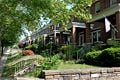
| − | [[Image:Parkside1.jpg|thumb|125px|[[Belair-Edison, Baltimore|Belair-Edison]]]]
| + | <center><gallery> |
| − | [[Image:1pondhomeland.jpg|thumb|125px|[[Homeland, Baltimore|Homeland]]]]
| + | Image:Parkside1.jpg|Belair-Edison |
| − | [[Image:Woodberry07.JPG|thumb|125px|[[Woodberry, Baltimore|Woodberry]]]]
| + | Image:Woodberry07.JPG|Woodberry |
| − | [[Image:STWPNTW.jpg|thumb|125px|[[Stonewood-Pentwood-Winston, Baltimore|Stonewood]]]]
| + | Image:Station North Arts District Baltimore Chas St.jpg|Station North |
| − | [[Image:Guilford.jpg|thumb|125px|[[Charles Village]]]]
| + | Image:Fells Point A.JPG|Fells Point |
| − | [[Image:DSCF1284.JPG|thumb|left|125px|[[Carrollton Ridge, Baltimore|Carrollton Ridge]]]]
| + | </gallery></center> |
| − | [[Image:Station North Arts District Baltimore Chas St.jpg|thumb|left|125px|[[Station North Arts District|Station North]]]]
| |
| − | [[Image:Fells Point A.JPG|thumb|left|125px|[[Fells Point]]]]
| |
| − | Baltimore is officially divided into nine geographical regions: Northern, Northwestern, Northeastern, Western, Central, Eastern, Southern, Southwestern, and Southeastern, with each patrolled by a respective [[Baltimore Police Department]] district. However, it is not uncommon for locals to divide the city simply by East or West Baltimore, using Charles Street or [[I-83]] as a dividing line, and/or into North and South using Baltimore Street as a dividing line. | |
| − | | |
| − | The Central region of the city includes the [[Downtown Baltimore|Downtown]] area which is the location of Baltimore's main commercial area. Home to [[Harborplace]], The Camden Yards Sports Complex ([[Oriole Park at Camden Yards]] and [[M&T Bank Stadium]]), the [[Baltimore Convention Center|Convention Center]], and the [[National Aquarium in Baltimore]], the area also includes many nightclubs, bars and restaurants, shopping centers and various other attractions. It is also serves as the home to many of Baltimore's key business such as [[Legg Mason]] and [[Constellation Energy]]. In addition, the [[University of Maryland, Baltimore]] campus is housed in this area, with the long-associated [[University of Maryland Medical System]] adjacent to the school. The downtown core has mainly served as a commercial district with limited residential opportunities. However since 2002 the population in the downtown has doubled to 10,000 residents with a projection of 7,400 additional housing units coming available by 2012.<ref>Mirabella, Lorraine. "[http://www.ubalt.edu/jfi/jfi/Media/Balto_Sun/sun013007.htm Downtown jobs, housing boom]," ''[[The Baltimore Sun]]'', January 30, 2007</ref> The Central region also includes the areas north of the downtown core stretching up to the edge of [[Druid Hill Park]]. Included in the more northern part of the Central region are the neighborhoods of [[Mount Vernon, Baltimore|Mount Vernon]], Charles North, [[Reservoir Hill]], [[Bolton Hill]], Druid Heights, as well as several other neighborhoods. These neighborhoods include many residential options and are home to many of the city's cultural opportunities. [[Maryland Institute College of Art]], the [[Peabody Institute]] of music, the [[Lyric Opera House]], The [[Walters Art Museum]], The [[Joseph Meyerhoff Symphony Hall]], as well as several galleries are all located in this region.
| |
| − | | |
| − | The Northern region of the city lies directly north of the Central region and is bounded on the East by The Alameda and on the West by Pimlico Road is a suburban residential area home to many of the city's upper class residents in neighborhoods such as the [[Roland Park, Baltimore|Roland Park]]-Homeland-[[Guilford, Baltimore|Guilford]]-Cedarcroft area. The Northern region is home to many of Baltimore's notable universities such as [[Loyola College in Maryland|Loyola College]], [[The Johns Hopkins University]] and [[College of Notre Dame of Maryland]].
| |
| − | | |
| − | The Southern Region of the city, a mixed industrial and residential area, consists of the area of the city below the Inner Harbor east of the B&O railroad tracks. It is a mixed socio-economic region consisting of working class ethnically mixed neighborhoods such as [[Locust Point, Baltimore|Locust Point]]; the recently gentrified [[Federal Hill, Baltimore|Federal Hill]] area, home to many working professionals, pubs and restaurants; and low-income residential areas such as [[Cherry Hill, Baltimore|Cherry Hill]].
| |
| − | | |
| − | The Eastern part of the city consists of the Northeastern, Eastern, and Southeastern regions of the city. Northeastern Baltimore is primarily a residential neighborhood home to [[Morgan State University]] bounded by the city line on its Northern and Eastern boundaries, Sinclair Lane, Erdman Avenue, and Pulaski Highway on its southern boundaries and The Alameda on its western boundaries. It has undergone demographic shifts over many years and remains a diverse but predominantly [[African American]] region of the city.<ref>{{cite web|title=Profile of General Demographic Charaterics: Hillen|publisher=Baltimore City Planning Department|url= http://censusprofile.bnia.org/Hillen%20Demographic%20Profile.pdf|format=PDF|accessdate=2007-10-27}}</ref><ref>{{cite web|title=Profile of General Demographic Characteristics: New Northwood|publisher=Baltimore City Planning Department|url=http://censusprofile.bnia.org/New%20Northwood%20Demographic%20Profile.pdf|format=PDF|accessdate=2007-10-27}}</ref><ref>{{cite web|title=Profile of General Demographic Characteristics: Stonewood-Pentwood-Winston|publisher=Baltimore City Planning Department|url= http://censusprofile.bnia.org/Stonewood-Pentwood-Winston%20Demographic%20Profile.pdf|format=PDF|accessdate=2007-10-27}}</ref>
| |
| − |
| |
| − | The Eastern region is the heart of what is considered "East Baltimore" and is home to [[Johns Hopkins Hospital]]. Located below Erdman Avenue and Sinclair Lane above Orleans Street, it is almost an exclusively [[African American]] area home to low-income residential neighborhoods, several of which constitute many of Baltimore's high crime areas.
| |
| − | | |
| − | The Southeastern region of the city is located below Orleans Street bordering the Inner Harbor on its western boundary,the city line on its eastern boundaries and the Baltimore harbor on its southern boundaries is a mixed industrial and residential area. Home to many young professionals and working class people, it is an ethnically rich section of Baltimore home to many [[Polish Americans]], [[Greek Americans]], [[African Americans]], and [[Italian Americans]]. [[Upper Fells Point]] is the center of the city's steadily growing [[Latino]] population.
| |
| − | | |
| − | The Western part of the city consists of the Northwestern, Western, and Southwestern regions of Baltimore. The Northwestern region of the city bounded by the county line on its northern and western boundaries, [[Gwynns Falls Parkway]] on the south and Pimlico Road on the East is a predominantly residential area home to [[Pimlico Race Course]], [[Sinai Hospital]] and several of Baltimore's Synagogues. Once the center of Baltimore's [[Jewish]] community, it has undergone [[white flight]] since the 1960s and has become an almost exclusively [[African American]] area. It is home to many suburban residential areas primarily located above Northern Parkway and several lower-income areas below Northern parkway.
| |
| − | | |
| − | The Western region of the city located west of downtown is the heart of "West Baltimore" bounded by Gwynns Falls Parkway, Fremont Avenue, and Baltimore Street. Home to [[Coppin State University]] and Pennsylvania Avenue, it has been the center of Baltimore's [[African American]] culture for years home to many of the city's historical African American neighborhoods and landmarks. Once home to many middle to upper class African Americans, over the years, the more affluent African American residents have since left migrating to other sections of the city in addition to areas such as [[Randallstown, Maryland|Randallstown]] and [[Owings Mills, Maryland|Owings Mills]] in [[Baltimore County]] and Columbia in [[Howard County, Maryland|Howard County]]. The area now constitutes a deprived socio-economic group of African American residents and like "East Baltimore," it is known for its high crime rates. Television series, such as ''[[The Wire (TV series)|The Wire]]'', that concern themselves with Baltimore's crime problems have been based on events that took place in West Baltimore.
| |
| − | | |
| − | The Southwestern region of the city is bounded by Baltimore County to the west, Baltimore Street to the north, and downtown and the B&O railroad to the east. A mixed industrial and residential area, it has gradually shifted from having a predominantly White to a predominantly [[African American]] majority.
| |
| | | | |
| | ==History== | | ==History== |
| − | [[Image:Balt. Battle Monument 1a.jpg|thumb|upright|right|Battle Monument commemorates the Battle of Baltimore.]] | + | [[Image:Harpers 8 11 1877 6th Regiment Fighting Baltimore.jpg|thumb|upright|Sixth Regiment fighting railroad strikers, July 20, 1877.]] |
| − | The Maryland colonial General Assembly created the Port of Baltimore at Locust Point in 1706 for the tobacco trade. The Town of Baltimore was founded on July 30, 1729, and is named after Lord Baltimore (Cecilius Calvert), who was the first Proprietary Governor of the Province of Maryland. The name "Baltimore" comes from the town of Baltimore, County Cork. Baltimore grew swiftly in the 18th century as a granary for sugar-producing colonies in the [[Caribbean]]. The profit from [[sugar]] encouraged the cultivation of cane and the importation of food. Baltimore's shorter distance from the Caribbean, compared to other large port cities such as [[New York City]] and [[Boston, Massachusetts|Boston]], reduced transportation time and minimized the spoilage of flour.
| + | [[Image:Baltimore Fire 1904 - West from Pratt and Gay Streets 3a.jpg|thumb|right|[[Great Baltimore Fire of 1904]], looking West from Pratt and Gay Streets.]] |
| | | | |
| − | Baltimore played a key part in events leading to and including the [[American Revolution]]. City leaders such as [[Jonathan Plowman Jr.]] moved the city to join the resistance to British taxes and merchants signed agreements to not trade with Britain.After the war, the Town of Baltimore, nearby Jonestown, and an area known as Fells Point were incorporated as the City of Baltimore in 1797. The city remained a part of Baltimore County until 1851 when it was made an independent city.<ref>{{cite web|url=http://www.msa.md.gov/msa/mdmanual/36loc/bcity/html/bcity.html|title=Baltimore, Maryland - Government|work=Maryland Manual On-Line: A Guide to Maryland Government|publisher=Maryland State Archives|date=2008-10-23|accessdate=2008-10-27}}</ref> | + | The [[Maryland]] colonial General Assembly created the Port of Baltimore at Locust Point in 1706 for the [[tobacco]] trade. The Town of Baltimore was founded on July 30, 1729. Baltimore grew swiftly in the eighteenth century as a granary for [[sugar]]-producing colonies in the [[Caribbean]]. The profit from sugar encouraged the cultivation of cane. Baltimore's shorter distance from the Caribbean, compared to other large port cities such as [[New York City]] and [[Boston, Massachusetts|Boston]], reduced transportation time and minimized the spoilage of [[flour]]. |
| | | | |
| − | The city was the site of the [[Battle of Baltimore]] during the [[War of 1812]]. After burning [[Washington, D.C.]], the British attacked Baltimore on the night of September 13, 1814. United States forces from [[Fort McHenry]] successfully defended the city's harbor from the British. [[Francis Scott Key]], a Maryland lawyer, was aboard a British ship where he had been negotiating for the release of an American prisoner, Dr. William Beanes. Key witnessed the bombardment from this ship and later wrote "[[The Star-Spangled Banner]]," a poem recounting the attack. Key's poem was set to a 1780 tune by British composer [[John Stafford Smith]], and the Star-Spangled Banner became the official [[National Anthem]] of the United States in 1931.
| + | Baltimore played a key role in events leading to and during the [[American Revolution]]. City leaders moved the city to join the resistance to British taxes and merchants signed agreements to not trade with Britain. After the war, the Town of Baltimore, nearby Jonestown, and an area known as Fells Point were incorporated as the City of Baltimore in 1797. The city remained a part of Baltimore County until 1851 when it was made an independent city. |
| | | | |
| − | [[Image:Harpers 8 11 1877 6th Regiment Fighting Baltimore.jpg|thumb|upright|left|Sixth Regiment fighting railroad strikers, July 20, 1877<ref>{{cite web |url=http://www.catskillarchive.com/rrextra/sk7711.Html |title=The Great Strike |accessdate=2008-10-26 |work=Catskill Archive |publisher=Timothy J. Mallery }}</ref>]] | + | The city was the site of the Battle of Baltimore during the [[War of 1812]]. After burning [[Washington, D.C.]], the British attacked Baltimore on the night of September 13, 1814. United State forces from [[Fort McHenry]] successfully defended the city's [[harbor]] from the British. [[Francis Scott Key]], a lawyer, was aboard a British ship where he had been negotiating for the release of an American prisoner. Key witnessed the bombardment from this ship and later wrote "[[The Star-Spangled Banner]]," a poem recounting the attack. Key's poem was set to a 1780 tune by British composer John Stafford Smith, and the "Star-Spangled Banner" became the official [[national anthem]] of the [[United States]] in 1931. |
| | | | |
| − | Following the Battle of Baltimore, the city's population grew rapidly. The construction of the Federally-funded [[National Road]] (presently [[U.S. Route 40]]) and the private [[Baltimore & Ohio Railroad]] (B&O) made Baltimore a major shipping and manufacturing center by linking the city with major markets in the [[Midwestern United States|Midwest]]. A distinctive local culture started to take shape, and unique skyline developed peppered with churches and monuments. Baltimore acquired its moniker , "Monument City" after an 1827 visit to Baltimore by President [[John Quincy Adams]]. At an evening function Adams gave the following toast: "Baltimore: the Monumental City- May the days of her safety be as prosperous and happy, as the days of her dangers have been trying and triumphant."<ref name="salgaz"/>
| + | In the years after the war, the city's population grew rapidly. The construction of the federally funded [[National Road]] (presently U.S. Route 40) and the private [[Baltimore & Ohio Railroad]] (B&O) made Baltimore a major [[shipping]] and [[manufacturing]] center by linking the city with major markets in the [[Midwestern United States|Midwest]]. |
| | | | |
| − | Maryland did not secede during the [[American Civil War]], but remained a part of the United States. However, when [[Union (American Civil War)|Union]] soldiers marched through the city at the start of the war, Confederate sympathizers attacked the troops, which led to the [[Baltimore riot of 1861]]. Four soldiers and 12 civilians were killed during the riot, which caused Union troops to occupy Baltimore. Maryland came under direct federal administration — in part, to prevent the state from seceding — until the end of the war in April 1865. | + | Maryland did not secede during the [[American Civil War|Civil War]]. When [[Union (American Civil War)|Union]] soldiers marched through the city at the start of the war, [[Confederacy|Confederate]] sympathizers attacked the troops, which led to the Baltimore riot of 1861. Four soldiers and 12 civilians were killed during the riot, which caused Union troops to occupy Baltimore. Maryland came under direct federal administration—in part, to prevent the state from seceding—until the end of the war in April 1865. |
| | | | |
| − | Following an economic depression known as the [[Panic of 1873]], the Baltimore & Ohio Railroad company attempted to reduce its workers wages, leading to the [[Great Railroad Strike of 1877]]. On July 20, Maryland Governor [[John Lee Carroll]] called up the 5th and 6th Regiments of the [[Maryland Army National Guard|National Guard]] to end the strikes, which had disrupted train service at [[Cumberland, Maryland|Cumberland]] in western Maryland. Citizens sympathetic to the railroad workers attacked the national guard troops as they marched from their armories in Baltimore to [[Camden Station]]. Soldiers from the 6th Regiment fired on the crowd, killing 10 and wounding 25. Rioters then damaged B&O trains and burned portions of the rail station. Order was restored in the city on July 21—22 when federal troops arrived to protect railroad property and end the strike.<ref>{{cite book|last=Scharf|first=J. Thomas|title=History of Maryland From the Earliest Period to the Present Day|publisher=Tradition Press|location=Hatboro, PA|year=1967|edition=2nd|volume=3|pages=733–42}}</ref>
| + | On February 7, 1904, the Great Baltimore Fire destroyed over 1,500 buildings in 30 hours and forced most of the city to rebuild. The city grew in area by annexing new suburbs from the surrounding counties. |
| − | [[Image:Baltimore Fire 1904 - West from Pratt and Gay Streets 3a.jpg|thumb|right|[[Great Baltimore Fire]] of 1904, looking West from Pratt and [[Gay Street (Baltimore)|Gay Streets]].]]
| |
| − | On February 7, 1904 the [[Great Baltimore Fire]] destroyed over 1,500 buildings in 30 hours and forced most of the city to rebuild. Two years later, on September 10, 1906, the [[Baltimore News-American|''Baltimore American'']] newspaper reported that the city had risen from the ashes and "one of the great disasters of modern time had been converted into a blessing."{{fact|date=September 2008}} The city grew in area by annexing new suburbs from the surrounding counties, the last being in 1918. A state constitutional amendment approved in 1948, requires a special vote of the citizens in any proposed annexation area, which effectively prevents the any future expansion of the city's boundaries.<ref>{{cite news|title=Baltimore seals its borders|last=Duffy|first=James|date=December 2007|work=Baltimore Magazine|pages=124-27}}</ref> | |
| | | | |
| − | The [[Baltimore riot of 1968]] occurred following the assassination of [[Martin Luther King, Jr.]] in [[Memphis, Tennessee]] on April 4, 1968. Coinciding with riots in other cities, public order was not restored until April 12, 1968. The Baltimore riot cost the city of Baltimore an estimated $10 million (about $63 million in 2008). Maryland National Guard troops and 1,900 federal troops were ordered into the city. Lasting effects of the riot can be seen on the streets of [[North Avenue (Baltimore)|North Avenue]], [[Howard Street (Baltimore)|Howard Street]], and [[Maryland Route 140|Pennsylvania Avenue]] where long stretches of the streets remain barren.<ref>{{cite web|url=http://www.ubalt.edu/template.cfm?page=1639|title=Baltimore Riots of 1968: A Timeline|publisher=University of Baltimore|accessdate=2008-09-11}}</ref>
| + | A [[riot]] occurred in the city following the assassination of [[Martin Luther King, Jr.]] in Memphis, [[Tennessee]], on April 4, 1968, coinciding with riots in other cities. The riot cost the city an estimated $10 million (about $63 million in 2008 dollars). Lasting effects of the riot can be seen on some streets, where long stretches remain barren. |
| | | | |
| − | During the 1970s, Baltimore's downtown area known as the [[Inner Harbor]], had been neglected and was only occupied by a collection of abandoned warehouses. Efforts to redevelop the downtown area started with the construction of the [[Baltimore Convention Center]], which opened 1979. [[Harborplace]], an urban retail and restaurant complex opened on the waterfront in 1980, followed by the [[National Aquarium in Baltimore]], Maryland's largest tourist destination, and the [[Baltimore Museum of Industry]] in 1981. In 1992, the [[Baltimore Orioles]] [[Major League Baseball|baseball team]] moved from [[Memorial Stadium (Baltimore)|Memorial Stadium]] to [[Oriole Park at Camden Yards]], located downtown near the harbor. Six years later the [[Baltimore Ravens]] [[National Football League|football team]] moved into [[M&T Bank Stadium]] next to Camden Yards.<ref>{{cite web|url=http://www.mdstad.com/index.php?option=com_content&task=view&id=12&Itemid=26|title=Who We Are|work=Maryland Stadium Authority|accessdate=2008-10-26}}</ref> On January 17, 2007, [[Sheila Dixon]] became the first female Mayor of Baltimore.<ref>{{cite news|title=Dixon Takes Oath|last=Fritze|first=John|date=2007-01-19|work=The Baltimore Sun|accessdate=2008-09-11}}</ref> | + | During the 1970s, Baltimore's downtown area, known as the Inner Harbor, had been neglected and was only occupied by a collection of abandoned warehouses. Efforts to redevelop the area began with the construction of the Baltimore Convention Center, which opened in 1979. Harborplace, an urban retail and restaurant complex, opened on the waterfront in 1980, followed by the [[National Aquarium in Baltimore|National Aquarium]]—Maryland's largest [[tourism|tourist]] destination—in 1981. In 1992, the Baltimore Orioles [[Major League Baseball|baseball team]] moved to [[Oriole Park]] at [[Camden Yards]], located downtown near the harbor. Six years later the Baltimore Ravens [[National Football League|football team]] moved into M&T Bank Stadium next to Camden Yards. |
| | | | |
| − | The city has a number of properties on the [[National Register of Historic Places listings in Baltimore (Independent City)|National Register of Historic Places]].<ref name="nris">{{cite web|url=http://www.nr.nps.gov/|title=National Register Information System|date=2008-04-15|work=National Register of Historic Places|publisher=National Park Service}}</ref>
| + | On January 17, 2007, Sheila Dixon became the first female mayor of Baltimore. |
| | | | |
| | ==Government and politics== | | ==Government and politics== |
| | + | [[Image:1city hall baltimore.jpg|thumb|right|250px|Baltimore City Hall]] |
| | + | Baltimore is an independent [[city]]—not part of any [[county]]. For most governmental purposes under Maryland law, Baltimore City is treated as a "county"-level entity. |
| | | | |
| − | Baltimore is an [[independent city]] — not part of any [[county]]. For most governmental purposes under Maryland law, Baltimore City is treated as a "county"-level entity. The [[United States Census Bureau]] uses counties as the basic unit for presentation of statistical information in the United States, and treats Baltimore as a county equivalent for those purposes. | + | Baltimore has been a [[Democratic Party (United States)|Democratic]] stronghold for over 150 years, with Democrats dominating every level of government. |
| | | | |
| − | Baltimore has been a [[United States Democratic Party|Democratic]] stronghold for over 150 years, with Democrats dominating every level of government.
| + | ;Mayor |
| | + | On November 6, 2007, incumbent Democratic Mayor Sheila Dixon was elected mayor. Dixon, as former City Council president, had assumed the office on January 17, 2007, when former Mayor Martin O'Malley took office as the governor of Maryland. |
| | | | |
| − | ===Mayor===
| + | ;Baltimore City Council |
| − | [[Image:1city hall baltimore.jpg|thumb|right|250px|Baltimore City Hall]]
| + | Grassroots pressure for reform restructured the city council in November 2002, against the will of the mayor, the council president, and the majority of the council. A coalition of union and community groups backed the effort. The council is now made up of 14 single-member districts and one elected at-large council president. |
| − | On November 6, 2007, incumbent Democratic Mayor Sheila Dixon was elected mayor. Dixon, as former City Council president, assumed the office of mayor on January 17, 2007, when former Mayor Martin O'Malley took office as the governor of Maryland.
| |
| | | | |
| − | ===Baltimore City Council===
| + | ;State government |
| | + | Prior to 1969, some considered Baltimore and its suburbs to be underrepresented in the Maryland General Assembly, while rural areas were heavily overrepresented. Since the court decision in ''Baker v. Carr'' in 1962, Baltimore and its suburbs account for a substantial majority of seats in the state legislature; this has caused some to argue that rural areas are now underrepresented. Baltimore's steady loss of population, however, has resulted in a loss of seats in the Maryland General Assembly. Since 1980, Baltimore has lost four senators from the 47-member Maryland State Senate and 12 delegates from the 141-member Maryland House of Delegates. |
| | | | |
| − | Grassroots pressure for reform, voiced as [[Question P]], restructured the city council in November 2002, against the will of the mayor, the council president, and the majority of the council. A coalition of union and community groups, organized by [[ACORN]], backed the effort.
| + | ;Federal government |
| | + | Three of the state's eight congressional districts include portions of Baltimore. All three seats are held by Democrats; a Republican has not represented a significant portion of Baltimore since 1931 and has not represented any of Baltimore since 2003. |
| | | | |
| − | The [[Baltimore City Council]] is now made up of 14 single member districts and one elected at-large council president. [[Stephanie Rawlings Blake]] is the council's president and Robert W. Curran is the Vice President.
| + | ==Economy== |
| | + | Once an industrial town, with an economic base focused on [[steel]] processing, shipping, [[automobile|auto]] [[manufacturing]], and [[transportation]], Baltimore now has a modern service economy. Although de-industrialization took its toll on the city, costing residents tens of thousands of low-skilled, high-wage jobs, the city is a growing financial, business, and health service base for the southern Mid-Atlantic region. The city is also home to [[Johns Hopkins Hospital]], which will serve as the center of a new [[biotechnology]] park, one of two such projects under construction in the city in 2008.. |
| | | | |
| − | ===State government=== | + | ===Port of Baltimore=== |
| − | Prior to 1969, some considered Baltimore and its suburbs to be particularly underrepresented in the Maryland General Assembly, while rural areas were heavily overrepresented. Since ''Baker v. Carr'' in 1962, Baltimore and its suburbs account for a substantial majority of seats in the state legislature; this has caused some to argue that rural areas are now underrepresented. Baltimore's steady loss of population, however, has resulted in a loss of seats in the Maryland General Assembly. Since 1980, Baltimore has lost four senators from the 47-member Maryland State Senate and twelve delegates from the 141-member Maryland House of Delegates.
| + | [[Image:Washington Monument, 1849, from Federal Hill 1a.jpg|thumb|right|Baltimore harbor in 1849 with the prominent Washington Monument in the background]] |
| | + | The port was founded in 1706, preceding the founding of the city. The Maryland colonial legislature made the area near Locust Point the port of entry for the [[tobacco]] trade with [[England]]. Fells Point, the deepest point in the natural harbor, soon became the colony's main ship building center and later became a leader in the construction of clipper ships. The [[California]] [[Gold Rush]] led to many orders for fast vessels; many overland pioneers relied upon canned goods from Baltimore. At the end of the nineteenth century, [[Europe]]an ship lines had terminals for immigrants. The [[Baltimore and Ohio Railroad]] made the port a major transshipment point. Currently the port has major [[roll-on roll-off]] facilities, as well as bulk facilities, especially for steel handling. |
| | | | |
| − | ===Federal government===
| + | In 2007, Duke Realty Corporation began a development near the Port of Baltimore, named the Chesapeake Commerce Center. This new industrial park is located on the site of a former [[General Motors]] plant. The total project comprises {{convert|184|acre|km2}} in eastern Baltimore City and the site will yield {{convert|2800000|sqft|m2}} of warehouse/distribution and office space. Chesapeake Commerce Center has direct access to two major Interstate Highways (I-95 and I-895) and is located adjacent to two of the major Port of Baltimore Terminals. |
| − | Three of the state's eight congressional districts include portions of Baltimore: the 2nd, represented by Dutch Ruppersberger; the 3rd, represented by John Sarbanes; and the 7th, represented by Elijah Cummings. All three are Democrats; a Republican has not represented a significant portion of Baltimore since 1931 and has not represented any of Baltimore since 2003. Both of Maryland's senators, Ben Cardin and Barbara Mikulski, are from Baltimore.
| |
| − | ==Economy==
| |
| − | Once an industrial town, with an economic base focused on steel processing, shipping, auto manufacturing, and transportation, Baltimore now has a modern [[service economy]]. Although deindustrialization took its toll on the city, costing residents tens of thousands of low-skill, high-wage jobs, the city is a growing financial, business, and health service base for the southern Mid-Atlantic region.
| |
| | | | |
| − | Greater Baltimore is home to six Fortune 1000 companies, Constellation Energy, Grace Chemicals (in Columbia), Black & Decker (in Towson), Legg Mason, T. Rowe Price, and McCormick & Company (in Hunt Valley). Other companies that call Baltimore home include, Brown Advisory, Alex Brown, a subsidiary of Deutsche Bank (of Baltimore origin, and at the time of its acquisition, the oldest continuously-running investment bank in the United States), FTI Consulting, Vertis, Thomson Prometric, Performax, Sylvan Learning/Laureate Education, Under Armour, DAP, 180°, Old Mutual Financial Network, and Advertising.com.
| |
| − |
| |
| − | The city is also home to the Johns Hopkins Hospital, which will serve as the center of a new biotechnology park. The park, one of two such projects currently under construction in the city, will provide room for medical/technology start-ups as well as industry giants to tap into the wealth of knowledge in Baltimore. Baltimore is widely regarded as one of the world's most important repositories of medical knowledge.
| |
| | ===Transportation=== | | ===Transportation=== |
| − | [[Image:Baltimore light rail at BWI.agr.jpg|thumb|right|The [[Baltimore Light Rail]] provides service to [[Baltimore-Washington International Thurgood Marshall Airport]].]] | + | [[Image:Kbwi.jpg|thumb|Interior of Baltimore-Washington International Thurgood Marshall Airport, Baltimore's major commercial airport]] |
| − | The [[Interstate Highway System|interstate highway]]s serving Baltimore are [[Interstate 70 in Maryland|I-70]], [[I-83]] (the [[Jones Falls Expressway]]), [[Interstate 95 in Baltimore, Maryland|I-95]] (the [[John F. Kennedy Memorial Highway|John F. Kennedy Memorial Highway)]], [[Interstate 395 (Maryland)|I-395]], [[I-695 (MD)|I-695]] (the [[Baltimore Beltway]]), [[Interstate 795 (Maryland)|I-795 (the Northwest Expressway)]], [[Interstate 895 (Maryland)|I-895 (the Harbor Tunnel Thruway)]], and [[Interstate 97|I-97]]. Several of the city's interstate highways, e.g. I-95, I-83, and I-70 are not directly connected to each other, and in the case of I-70 end just outside city limits at the Baltimore Beltway, because of [[freeway and expressway revolts|freeway revolts]] in the City of Baltimore. These revolts were led [[Barbara Mikulski]], now [[United States Senator]], which resulted in the abandonment of the original plan. [[United States Numbered Highways|U.S. highways]] and state routes that run to and through downtown Baltimore include [[U.S. Route 1 in Maryland|U.S. 1]], [[U.S. Route 40]] [[National Road]], and the [[Baltimore-Washington Parkway]]. There are two tunnels traversing the [[Inner Harbor|Baltimore harbor]] within the city limits: the four-bore [[Fort McHenry Tunnel]] (served by I-95) and the two-bore [[Baltimore Harbor Tunnel|Harbor Tunnel]] (served by I-895). The [[Interstate 695 (Maryland)|Baltimore Beltway]] crosses south of Baltimore harbor over the [[Francis Scott Key Bridge (Baltimore)|Francis Scott Key Bridge]].
| + | Two tunnels traverse the Baltimore harbor within the city limits: the four-bore Fort McHenry Tunnel (served by I-95) and the two-bore Harbor Tunnel (served by I-895). The Baltimore Beltway crosses south of Baltimore harbor over the Francis Scott Key Bridge. |
| | | | |
| − | Baltimore is a top destination for [[Amtrak]] along the [[Northeast Corridor]]. Baltimore's [[Pennsylvania Station (Baltimore)|Penn Station]] is one of the busiest in the country. In 2005, it ranked 8th in the United States with a total ridership of 910,523.<ref>[http://www.amtrak.com/servlet/ContentServer?pagename=Amtrak/am2Copy/Title_Image_Copy_Page&cid=1081442674300&c=am2Copy&ssid=424 25 Busiest stations in 2005]. Inside Amtrak. Government Affairs. Amtrak Information. ''URL retrieved April 1, 2007''.</ref> Just outside the city, [[BWI Rail Station|Baltimore/Washington International (BWI) Thurgood Marshall Airport Rail Station]] is another popular stop. Amtrak's [[Acela Express]], [[Palmetto (Amtrak)|Palmetto]], [[Carolinian]], [[Silver Star (Amtrak)|Silver Star]], [[Silver Meteor]], [[Vermonter]], [[Crescent (Amtrak)|Crescent]], and [[Regional (Amtrak)|Regional]] trains are the scheduled passenger train services that stop in the city. Additionally, [[MARC Train|MARC commuter rail service]] connects the city's two main intercity [[Rail transport|rail]] [[Train station|stations]], [[Camden Station]] and Penn Station, with [[Washington, D.C.]]'s [[Union Station (Washington, D.C.)|Union Station]] as well as stops in between. | + | Baltimore is a top destination for [[Amtrak]] along the [[Northeast Corridor]]. Baltimore's [[Pennsylvania Station (Baltimore)|Penn Station]] is one of the busiest in the country. Additionally, the MARC commuter rail service connects the city's two main intercity rail stations, Camden Station and Penn Station, with [[Washington, D.C.]]'s Union Station as well as stops in between. |
| − | | |
| − | [[Image:Kbwi.jpg|thumb|left|Interior of Baltimore-Washington International Thurgood Marshall Airport, Baltimore's major commercial airport]]
| |
| − | | |
| − | Public transit in Baltimore is provided by the [[Maryland Transit Administration]]. The city has a comprehensive [[MTA Maryland Local Bus|bus]] network, [[Baltimore Light Rail|a small light rail network]] connecting [[Hunt Valley, Maryland|Hunt Valley]] in the north to [[Baltimore-Washington International Thurgood Marshall Airport|BWI airport]] and Cromwell in the south, and a [[Baltimore Metro Subway|subway line]] between [[Owings Mills, Maryland|Owings Mills]] and Johns Hopkins Hospital.<ref>[http://www.mtamaryland.com/ Maryland Transit Administration]. ''URL retrieved April 5, 2007''.</ref> A proposed bus rapid transit or rail line, known as the [[Red Line (Baltimore)|Red Line]], which would link the Social Security Administration to [[Fells Point]] and perhaps the Canton and [[Dundalk, Maryland|Dundalk]] communities, is under study as of 2007; a proposal to extend Baltimore's existing subway line to [[Morgan State University]], known as the [[Green Line (Baltimore)|Green Line]], is in the planning stage.<ref>[http://www.baltimoreregiontransitplan.com/ Baltimore Region Rail System Plan]. ''URL retrieved April 5, 2007''.</ref>
| |
| − | | |
| − | Baltimore is served by [[Baltimore-Washington International Thurgood Marshall Airport]], generally known as "BWI," which lies to the south in neighboring [[Anne Arundel County, Maryland|Anne Arundel County]], and by [[Martin State Airport]], a [[general aviation]] facility, to the north in [[Baltimore County, Maryland|Baltimore County]]. BWI and Martin State airports are operated by the Maryland Aviation Administration which is part of the [[Maryland Department of Transportation]].<ref>[http://www.marylandaviation.com/ Maryland Aviation Administration]. ''URL retrieved April 5, 2007''.</ref> In terms of passengers, BWI airport is the top 26th airport in the United States.<ref>[http://www.bwiairport.com/about_bwi/general_statistics/ General Statistics]. Baltimore/Washington International Airport. ''URL retrieved April 5, 2007''.</ref> Downtown Baltimore is connected to BWI airport by two major highways ([[Interstate 95 in Baltimore, Maryland|I-95]] and the [[Baltimore-Washington Parkway]] via [[Interstate 195 (Maryland)|Interstate 195]]), the [[Baltimore Light Rail]], and [[Amtrak]] and [[MARC Train|MARC commuter rail service]] between Baltimore's Penn Station and [[BWI Rail Station]]. Martin State Airport is linked to downtown Baltimore by two major highways, I-95 and [[U.S. Route 40]], and MARC commuter rail service between Baltimore's Penn Station and its nearby Martin State Airport MARC Train stop.
| |
| − | | |
| − | ===Port of Baltimore===
| |
| − | [[Image:Washington Monument, 1849, from Federal Hill 1a.jpg|thumb|right|Baltimore harbor in 1849 with the prominent [[Washington Monument (Baltimore)|Washington monument]] in the background North of the city]]
| |
| − | The port was founded 1706, preceding the founding of Baltimore. The Maryland colonial legislature made the area near [[Locust Point, Baltimore|Locust Point]] as the [[port of entry]] for the [[tobacco]] trade with England. [[Fells Point]], the deepest point in the natural harbor, soon became the colony's main ship building center, later on becoming leader in the construction of clipper ships.<ref>[http://www.portofbaltimore300.org/history.htm History of the Port of Baltimore], Port of Baltimore Tricentennial Committee.</ref> After the founding of Baltimore, mills were built behind the wharves. The [[California Gold Rush]] led to many orders for fast vessels; many overland pioneers also relied upon canned goods from Baltimore. After the civil war, a coffee ship was designed here for trade with Brazil. At the end of the nineteenth century, European ship lines had terminals for immigrants. The [[Baltimore and Ohio Railroad]] made the port a major [[transshipment]] point.{{fact|date=September 2008}}
| |
| − | | |
| − | Currently the port has major [[roll-on roll-off]] facilities, as well as bulk facilities, especially steel handling.<ref>
| |
| − | [http://www.mpa.state.md.us/info/cargo.htm The Port of Baltimore's Cargo], Maryland Port Administration].</ref>
| |
| − | Water taxis also operate in the Inner Harbor. Governor Ehrlich participated in naming the port after [[Helen Delich Bentley]] during the 300th anniversary of the port.<ref>[http://www.teslasociety.com/bentley.htm Governor Ehrlich Names Port Of Baltimore After Helen Delich Bentley], Tesla Memorial Society of New York.</ref>
| |
| − | | |
| − | In 2007, Duke Realty Corporation began a new development near the Port of Baltimore, named the Chesapeake Commerce Center. This new industrial park is located on the site of a former General Motors plant. The total project comprises {{convert|184|acre|km2}} in eastern Baltimore City and the site will yield {{convert|2800000|sqft|m2}} of warehouse/distribution and office space. Chesapeake Commerce Center has direct access to two major Interstate Highways (I-95 and I-895) and is located adjacent to two of the major Port of Baltimore Terminals. The Port of Baltimore is the furthest inland port in the U.S. with a {{convert|50|ft|m|sing=on}} dredge to accommodate the largest shipping vessels.{{fact|date=September 2008}}
| |
| | | | |
| | + | Public transit in Baltimore is provided by the Maryland Transit Administration. The city has a comprehensive bus network, a small light rail network connecting Hunt Valley in the north to the [[airport]] in the south, and a subway line between Owings Mills and Johns Hopkins Hospital. |
| | | | |
| | + | Baltimore is served by [[Baltimore-Washington International Thurgood Marshall Airport]], generally known as "BWI," which lies to the south in neighboring Anne Arundel County. In terms of passengers, BWI airport is the twenty-sixth top airport in the [[United States]]. |
| | | | |
| | ==Demographics== | | ==Demographics== |
| | + | Baltimore was among the top 10 cities in population in the [[United State]]s in every census up to the 1980 census, and after [[World War II]] had a [[population]] of nearly a million. The [[city]] and metropolitan area currently rank in the top 20 in terms of population. In the 1990s, the Unites States census reported that Baltimore ranked as one of the largest population losers alongside [[Detroit, Michigan]] and [[Washington, D.C.]], losing over 84,000 residents between 1990 and 2000.<ref>''Pearson Education; Infoplease''. [http://www.infoplease.com/ipa/A0763098.html Top 50 Cities in the U.S. by Population and Rank]. Retrieved December 30, 2008.</ref> |
| | | | |
| − | After [[New York City]], Baltimore was the second city in the United States to reach a population of 100,000, (followed by [[New Orleans, Louisiana|New Orleans]], [[Philadelphia, Pennsylvania|Philadelphia]], [[Boston, Massachusetts|Boston]]).<ref>United States census data for [http://www.census.gov/population/documentation/twps0027/tab06.txt 1830], [http://www.census.gov/population/documentation/twps0027/tab07.txt 1840], and [http://www.census.gov/population/documentation/twps0027/tab08.txt 1850]</ref> In the 1830, 1840, and 1850 [[census]]es of the [[United States|United States of America]], Baltimore was the second-largest city in population, surpassed by Philadelphia in 1860. It was among the top 10 cities in population in the United States in every census up to the 1980 census, and after World War II had a population of nearly a million. The city and metropolitan area currently rank in the top 20 in terms of population. In the 1990s, the US Census reported that Baltimore ranked as one of the largest population losers alongside [[Detroit]] and [[Washington D.C.]], losing over 84,000 residents between 1990 and 2000.<ref>[http://www.infoplease.com/ipa/A0763098.html "Top 50 Cities in the U.S. by Population and Rank (2005 Census)"]. [http://infoplease.com infoplease.com]. 2005. Retrieved August 1, 2006</ref>
| + | As of 2006, the [[population]] was 637,455. The Baltimore–Towson metropolitan area, as of 2004, was estimated to have a population of 2.6 million. The [[population density]] was 8,058.4 people per square mile (3,111.5/km²). There were 300,477 housing units at an average density of 3,718.6/sq mi (1,435.8/km²). The racial makeup of the city was 64.85 percent [[African American]], 31.28 percent [[Caucasian]], 0.32 percent [[Native American]], 1.53 percent [[Asia]]n, 0.03 percent [[Pacific Islander]], 0.67 percent from other races, and 1.47 percent from two or more races. 1.70 percent of the population were [[Hispanics in the United States|Hispanic]] or [[Latino (U.S. Census)|Latino]] of any race. This census, however, does not accurately represent the city's Latino population, which has been steadily increasing in recent decades. <ref>''US Census Bureau''. [http://quickfacts.census.gov/qfd/states/24/24510.html Baltimore city, Maryland] Retrieved December 30, 2008.</ref> 6.2 percent of the population were of [[Germany|German]] ancestry, according to the 2000 census. About 18.8 percent of families and 22.9 percent of the population were below the [[poverty]] line, including 30.6 percent of those under age 18 and 18.0 percent of those ages 65 or over. |
| − | | |
| − | According to the 2007 American Community Survey, the city's population was 32.4% White (30.4% non-Hispanic-White alone), 64.6% Black or African American, 0.8% American Indian and Alaska Native, 2.2% Asian, 0.1% Native Hawaiian and Other Pacific Islander, 1.4% from some other race and 1.3% from two or more races. 2.4% of the total population were Hispanic or Latino of any race. [http://factfinder.census.gov/servlet/ADPTable?_bm=y&-context=adp&-qr_name=ACS_2007_3YR_G00_DP3YR5&-ds_name=ACS_2007_3YR_G00_&-tree_id=3307&-redoLog=true&-_caller=geoselect&-geo_id=16000US2404000&-format=&-_lang=en]
| |
| − |
| |
| − | As of 2006, the [[population]] was 637,455. The Baltimore–Towson metropolitan area, as of 2004, was estimated to have a population of 2.6 million.<ref>[http://www.census.gov/population/www/estimates/metropop/table01.xls Annual Estimates of the Population of Metropolitan and Micropolitan Statistical Areas: April 1, 2000 to July 1, 2004 (CBSA-EST2004-01)]</ref> The [[population density]] was 8,058.4 people per square mile (3,111.5/km²). There were 300,477 housing units at an average density of 3,718.6/sq mi (1,435.8/km²). The racial makeup of the city was 64.85% [[Race (United States Census)|African American]], 31.28% [[Caucasian (U.S. Census)|White]], 0.32% [[Native American (U.S. Census)|Native American]], 1.53% [[Asian (U.S. Census)|Asian]], 0.03% [[Pacific Islander (U.S. Census)|Pacific Islander]], 0.67% from other races, and 1.47% from two or more races. 1.70% of the population were [[Hispanics in the United States|Hispanic]] or [[Latino (U.S. Census)|Latino]] of any race. This census, however, does not accurately represent the city's Latino population, which, over the past few years, has been steadily increasing. This growth is mainly seen in the southeastern neighborhoods around Upper Fells Point, Patterson Park, and Highlandtown, and in the city's Northwestern neighborhoods such as Fallstaff, as well as various neighborhoods of Northeastern Baltimore.<ref>{{cite web|url=http://quickfacts.census.gov/qfd/states/24/24510.html|title=Baltimore city QuickFacts from the US Census Bureau|accessdate=2007-04-30}}</ref> 6.2% of the population were of [[german people|German]] ancestry according to [[Census 2000]]. | |
| − | | |
| − | There were 257,996 households, out of which 25.5% had children under the age of 18 living with them, 26.7% were [[Marriage|married couples]] living together, 25.0% had a female householder with no husband present, and 43.0% were non-families. 34.9% of all households are made up of individuals, and 11.3% had someone living alone who was 65 years of age or older. The average household size was 2.42, and the average family size was 3.16.
| |
| − | | |
| − | In the city, the population age spreads were 24.8% for persons under the age of 18, 10.9% for ages 18 to 24, 29.9% for ages 25 to 44, 21.2% for ages 45 to 64, and 13.2% were 65 years of age or older. The median age was 35 years. For every 100 females there were 87.4 males. For every 100 females age 18 and over, there were 82.9 males.
| |
| − | | |
| − | The median income for a household in the city was $30,078, and the median income for a family was $35,438. Males had a median income of $31,767 versus $26,832 for females. The [[per capita income]] for the city was $16,978. About 18.8% of families and 22.9% of the population were below the [[poverty line]], including 30.6% of those under age 18 and 18.0% of those age 65 or over.
| |
| | | | |
| | ===Crime=== | | ===Crime=== |
| − | According to crime statistics there were 276 homicides in Baltimore in 2006, the second-highest homicide rate per 100,000 of all U.S. cities of 250,000 or more population.<ref>{{cite web|url=http://www.fbi.gov/ucr/cius2006/data/table_08.html|title=Offenses Known to Law Enforcement by State by City, 2006|month=September | year=2007|work=Uniform Crime Report, 2006|accessdate=2008-09-12}}</ref> Though this is significantly lower than the record-high 353 homicides in 1993, the homicide rate in Baltimore is nearly seven times the national rate, six times the rate of [[New York City]], and three times the rate of [[Los Angeles, California|Los Angeles]]. | + | According to [[crime]] statistics there were 276 [[homicide]]s in Baltimore in 2006, the second-highest homicide rate per 100,000 of all United States cities of 250,000 or more population.<ref> |
| − | In addition, other categories of crime in Baltimore have also been declining, although overall crime rates are still high compared to the national average. The rate of forcible rapes has fallen below the national average in recent years; however, Baltimore still has much higher-than-average rates of aggravated assault, burglary, robbery, and theft.<ref>{{cite web | title="Baltimore Maryland Crime Statistics and Data Resources" | url=http://baltimore.areaconnect.com/crime1.htm}}</ref> Baltimore was ranked as the 12th most dangerous city in the United States in 2008.
| + | ''U.S. Department of Justice''. Offenses Known to Law Enforcement by State by City, 2006.</ref> Though this is significantly lower than the record-high 353 homicides in 1993, the homicide rate in Baltimore is nearly seven times the national rate, six times the rate of [[New York City]], and three times the rate of [[Los Angeles, California|Los Angeles]]. |
| | | | |
| − | City officials have, however, come under scrutiny from Maryland legislators regarding the veracity of crime statistics reported by the [[Baltimore City Police Department]].<ref>{{cite web | title="State Lawmaker Calls For Investigation Into Police" | url=http://www.thewbalchannel.com/news/7057074/detail.html}}, WBAL-TV (February 14, 2006) </ref> In 2003, the FBI identified irregularities in the number of rapes reported, which was confirmed by then-Mayor [[Martin O'Malley]]. The number of homicides in 2005 appeared to exhibit discrepancies as well.<ref>{{cite web | title="Homicide Rate, Police Procedures Questioned" | url=http://www.thewbalchannel.com/news/7056945/detail.html}}, WBAL-TV (February 14, 2006) </ref> The former police commissioner stated upon interview that the administration suppressed corrections to its crime reports;<ref>{{cite web | title="Ex-Commish Raised Questions During Tenure" | url=http://www.thewbalchannel.com/news/7341879/detail.html}}, WBAL-TV (February 22, 2006) </ref>
| + | Other categories of crime in Baltimore have also been declining, although overall crime rates are still high compared to the national average. The rate of forcible [[rape]]s has fallen below the national average in recent years; however, Baltimore still has much higher-than-average rates of aggravated assault, burglary, robbery, and theft.<ref>''Area Connect''. [http://baltimore.areaconnect.com/crime1.htm Baltimore Maryland Crime Statistics and Data Resources] Retrieved December 30, 2008.</ref> Baltimore was ranked as the twelfth most dangerous city in the United States in 2008. |
| − | however, many of the charges made by the police commission now appear to be politically motivated.<ref>John Wagner and Tim Craig, {{cite web | title="Duncan Rebukes O'Malley Over Crime" | url=http://www.washingtonpost.com/wp-dyn/content/article/2006/02/13/AR2006021301857.html}}, Washington Post (February 14, 2006) </ref> Under the administration of Mayor [[Sheila Dixon]] and a new police commissioner, crime rates have been reduced, including a 40% fall in the number of murders as of April 2008.<ref>{{cite web| title=Baltimore's Murder Rate| url=http://www.wbaltv.com/station/15574702/detail.html|publisher=WBAL-TV|accessdate=2008-04-02}}</ref> As of December 3, 2008 the city has had 216 homicides.{{Fact|date=December 2008}}
| |
| | | | |
| | + | City officials have, however, come under scrutiny from [[Maryland]] legislators regarding the veracity of crime statistics reported by the Baltimore City Police Department. In 2003, the [[FBI]] identified irregularities in the number of rapes reported. The number of homicides in 2005 appeared to exhibit discrepancies as well. However, many of the charges made by the police commission now appear to be politically motivated. Under the administration of Mayor Sheila Dixon and a new police commissioner, crime rates have been reduced, including a 40 percent fall in the number of murders as of April 2008.<ref>''WBAL-TV''. March 12, 2008. [http://www.wbaltv.com/station/15574702/detail.html Baltimore's Murder Rate] Retrieved December 30, 2008.</ref> As of December 3, 2008, the city had had 216 homicides. |
| | | | |
| | + | ==Education== |
| | + | [[Image:JHU-V.jpg|right|thumb|Undergraduates walk across Keyser Quadrangle in Spring at the Johns Hopkins University]] |
| | + | ===Elementary and secondary schools=== |
| | + | The Baltimore City Public School System in in charge of the [[education]] of approximately 90,000 children. It maintains about 173 schools, including Baltimore City College, the third oldest public high school in the country, and Western High School, the oldest public all-girls school in the nation. Partial control was ceded to the state in exchange for increased funding. The mayor and governor jointly appoint the school board that oversees the system. |
| | | | |
| − | ==Law Enforcement==
| |
| − | *The '''Baltimore City Police Department''' is the primary law enforcement agency servicing the citizens of Baltimore: see main article [[Baltimore City Police Department|here]].
| |
| − |
| |
| − | *The '''Baltimore City Sheriff's Office''' (BSO) is the enforcement arm of the Baltimore court system. Deputy Sheriffs are sworn law enforcement officials with full arrest authority as granted by the constitution of Maryland, the [[Maryland Police and Correctional Training Commission|MPCTC]] and the Sheriff of the City of Baltimore.<ref>http://www.baltimorecity.gov/government/sheriff/</ref>
| |
| − | **'''Organization'''-The current Sheriff is John W. Anderson. The BCSO is divided into several sections as follows:
| |
| − | ***Field Enforcement Section
| |
| − | ***District Court Section
| |
| − | ***Child Support (Civil) Section
| |
| − | ***Child Support (Warrant) Section
| |
| − | ***Transportation Unit
| |
| − | ***Warrant Unit
| |
| − | ***Special Response Team
| |
| − | ***[[K-9]] Team
| |
| − | ***Witness Protection Team
| |
| − |
| |
| − | **'''Duties'''-The Sheriff is responsible for the following: security of city courthouses and property, service of court-ordered writs, protective and peace orders, warrants, tax levies, as well as prisoner transportation and traffic enforcement.
| |
| − |
| |
| − | *The [[Maryland Transportation Authority Police]] is responsible for policing the tunnels and bridges under [[Maryland Transportation Authority|MTA]] jurisdiction and have concurrent jurisdiction with the Baltimore city police under a [[memorandum of understanding]] with the city police.
| |
| − |
| |
| − |
| |
| − |
| |
| − | ==Education==
| |
| | ===Colleges and universities=== | | ===Colleges and universities=== |
| − | Baltimore is the home of numerous places of higher learning, both public and private. Among them are: | + | Baltimore is the home of numerous places of higher learning, both public and private. Among the private schools are [[Johns Hopkins University]], [[College of Notre Dame of Maryland]], and [[Loyola College in Maryland]]. |
| − | ====Private====
| |
| − | [[Image:JHU-V.jpg|right|thumb|Undergraduates walk across Keyser Quadrangle in Spring at the [[Johns Hopkins University]]]]
| |
| − | *[[Baltimore Hebrew University]] (BHU)
| |
| − | *[[Baltimore International College]] (BIC)
| |
| − | *[[College of Notre Dame of Maryland]]
| |
| − | *[[The Johns Hopkins University]] (JHU)
| |
| − | *[[Loyola College in Maryland]] (LC)
| |
| − | *[[Maryland Institute College of Art]] (MICA)
| |
| − | *[[Peabody Institute]]
| |
| − | *[[Sojourner-Douglass College]]
| |
| − | | |
| − | ====Public====
| |
| − | *[[Baltimore City Community College]] (BCCC)
| |
| − | *[[Coppin State University]]
| |
| − | *[[Morgan State University]]
| |
| − | *[[University of Baltimore]] (UB)
| |
| − | *[[University of Maryland, Baltimore]] (UMB, formerly UMAB)
| |
| − | | |
| − | As well as those located within the city, several are located in the suburbs that surround the city. Major ones include:
| |
| − | *[[Community College of Baltimore County]] in [[Catonsville]], [[Essex, Maryland|Essex]], and [[Dundalk, Maryland|Dundalk]] (public)
| |
| − | *[[Anne Arundel Community College]] in [[Anne Arundel County]] (public)
| |
| − | *[[Goucher College]], in [[Towson, Maryland|Towson]] (private)
| |
| − | *[[Towson University]], in [[Towson, Maryland|Towson]] (public)
| |
| − | *[[University of Maryland, Baltimore County]] (UMBC), in [[Catonsville, Maryland|Catonsville]] (public)
| |
| − | *[[Stevenson University]], in [[Stevenson, Maryland|Stevenson]] and [[Owings Mills, Maryland|Owings Mills]] (private) (formerly Villa Julie College (2008))
| |
| − | *[[Ner Israel Rabbinical College]] in [[Pikesville, Maryland|Pikesville]] (private)
| |
| − | [[Image:Castle citycollege.JPG|thumb|right|[[Baltimore City College]], the third oldest public high school in the US, 2007]]
| |
| − | | |
| − | ===Primary and secondary schools===
| |
| − | <!-- This section should be kept short and simple—>
| |
| − | The city's public schools are operated by the [[Baltimore City Public School System]] and include [[Baltimore City College]], the third oldest public high school in the country, and [[Western High School (Baltimore, Maryland)|Western High School]], the oldest public all girls school in the nation. Baltimore City College ('City') and [[Baltimore Polytechnic Institute]] ('Poly') share the nation's second-oldest high school [[City–Poly football rivalry|football rivalry]]. Baltimore City College, Baltimore Polytechnic Institute, and Western High School constitute the hardest admissions policies of any public high school in Maryland.{{Fact|date=February 2008}}
| |
| − | ==== Private schools ====
| |
| | | | |
| − | These [[private school]]s are within the city:
| + | The public [[college]]s include Baltimore City Community College, Coppin State University, Morgan State University, University of Baltimore, and University of Maryland, Baltimore. |
| − | * [[Archbishop Curley High School]]
| |
| − | * [[Baltimore Junior Academy]]
| |
| − | * [[Bryn Mawr School|The Bryn Mawr School]]
| |
| − | * [[Boys' Latin School of Maryland]]
| |
| − | * [[Calvert School]]
| |
| − | * [[Cardinal Gibbons School]]
| |
| − | * [[School of the Cathedral of Mary our Queen]]
| |
| − | * [[Friends School of Baltimore]]
| |
| − | * [[Gilman School]]
| |
| − | * [[Institute of Notre Dame]]
| |
| − | * [[Mount Saint Joseph High School]]
| |
| − | * [[Roland Park Country School]]
| |
| − | * [[The Catholic High School of Baltimore]]
| |
| − | * [[Waldorf School of Baltimore]]
| |
| − | | |
| − | Some private schools are located in the nearby suburbs:
| |
| − | * [[Al-Rahmah School]]
| |
| − | * [[Arlington Baptist High School]]
| |
| − | * [[Baltimore Lutheran School]]
| |
| − | * [[Calvert Hall College High School]]
| |
| − | * [[Garrison Forest School]]
| |
| − | * [[Loyola Blakefield]]
| |
| − | * [[McDonogh School]]
| |
| − | * [[Oldfields School]]
| |
| − | * [[Park School of Baltimore|The Park School]]
| |
| − | * [[Ruxton Country Day school]]
| |
| − | * [[St. Paul's School (Brooklandville, Maryland)|St. Paul's School]]
| |
| − | * [[St. Paul's School for Girls]]
| |
| | | | |
| | ==Culture== | | ==Culture== |
| − | [[Image:Converted.png|thumb|right|The Washington Monument]] | + | [[Image:CamdenYards 2005-05-08.jpg|thumb|right|Oriole Park at Camden Yards]] |
| − | Historically a working-class port town, Baltimore has sometimes been dubbed a "city of neighborhoods," with over 300 identified districts traditionally occupied by distinct ethnic groups. Most notable today are three downtown areas along the port: the [[Inner Harbor]], frequented by tourists due to its hotels, shops, and museums; Fells Point, once a favorite entertainment spot for sailors but now refurbished and gentrified (and featured in the movie ''Sleepless in Seattle''); and Little Italy, located between the other two, where Baltimore's Italian-American community was based–and where current U.S. House Speaker Nancy Pelosi grew up. Further inland, Mt. Vernon is the traditional center of cultural and artistic life of the city; it is home to a distinctive Washington Monument, set atop a hill in a 19th century urban square, that predates the more well-known monument in Washington, D.C. by several decades. | + | Historically a working-class port town, Baltimore has sometimes been dubbed a "city of neighborhoods," with over 300 districts traditionally occupied by distinct ethnic groups. Most notable today are three downtown areas: the Inner Harbor, frequented by tourists due to its [[hotel]]s, shops, and [[museum]]s; Fells Point, once a favorite entertainment spot for sailors but now refurbished and gentrified; and Little Italy, located between the other two, where Baltimore's Italian-American community was based. Further inland, Mt. Vernon is the traditional center of cultural and artistic life of the city; it is home to a distinctive Washington Monument, set atop a hill in a nineteenth-century urban square, that predates the more well-known monument in [[Washington, D.C.]], by several decades. |
| − | | |
| − | [[Image:Bromo Seltzer tower.jpg|thumb|left|Bromo Seltzer Tower, erected in 1911]]
| |
| − | The traditional local accent has long been noted and celebrated as "[[Baltimorese]]" or "Bawlmorese." One thing outsiders quickly notice is that the locals refer to their city as "Bawlmer" or "Ballmer," dropping with the "t" for the most part. The dialect is similar to that of many Marylanders, Virginians and Pennsylvanians; it may reflect the region's roots in [[Cornwall]] and the English West Country, as many of the original settlers of the Chesapeake Bay area came from this area in colonial times (Traditionally, many Marylanders call their state "Merlin"—and likewise, many Pennsylvanians call their state "Pennsavania," dropping the "l"). However, Baltimore's local accent also reflects the rich mix of ethnic groups from Ireland, Germany, and southern and eastern Europe who immigrated to the city during the industrial era. More recently, local pronunciations of "Baldamore" or "Ballmore" have become common.
| |
| − | | |
| − | As Baltimore's demographics have changed since World War Two, its cultural flavor and accents have evolved as well. Today, after decades of out-migration to suburbs beyond its corporate limits and significant in-migration of black Americans from Georgia and the Carolinas, Baltimore has become a majority black city with a significantly changed, but still regionally distinctive, dialect and culture. Recently, neighborhoods such as Federal Hill and Canton have undergone extensive gentrification and have proven to be popular places for young professionals and college students to reside. In addition, Latinos are making their mark, notably in Upper Fells Point.
| |
| | | | |
| − | Much of Baltimore's black American culture has roots that long predate the 20th century [[Great Migration (African American)|"Great Migration"]] from the [[Deep South]]. Like [[Atlanta, Georgia]] and [[Washington, D.C.]], Baltimore has been home to a successful black middle class and professional community for centuries. Before the Civil War, Baltimore had one of the largest concentrations of free black Americans among American cities. In the twentieth century, Baltimore-born [[Thurgood Marshall]] became the first black American justice of the [[Supreme Court of the United States|U.S. Supreme Court]].
| + | As Baltimore's demographics have changed since [[World War II]], its cultural flavor and accents have evolved as well. Today, after decades of out-migration to suburbs beyond its corporate limits and significant in-migration of [[African American]]s from [[Georgia]] and the Carolinas, Baltimore has become a majority black city with a significantly changed, but still regionally distinctive, dialect and [[culture]]. Recently, neighborhoods such as Federal Hill and Canton have undergone extensive gentrification and have proven to be popular places for young professionals and college students to reside. In addition, Latinos are making their mark, notably in Upper Fells Point. |
| − | Baltimore's culture has been famously celebrated in the films of [[Barry Levinson]], who grew up in the city's Jewish neighborhoods. His movies [[Diner (film)|''Diner'']], ''[[Tin Men]]'', [[Avalon (1990 film)|''Avalon'']], and ''[[Liberty Heights]]'' are inspired to varying degrees by his life in the city.
| |
| | | | |
| − | Baltimore native [[John Waters (filmmaker)|John Waters]] parodies the city extensively in his films, including the 1972 cult classic ''[[Pink Flamingos]]''. His film ''[[Hairspray (1988 film)|Hairspray]]'' and its [[Hairspray (musical)|Broadway musical remake]] are also set in Baltimore. | + | Baltimore has been home to a successful black middle class and professional community for centuries. Before the [[American Civil War|Civil War]], Baltimore had one of the largest concentrations of free black Americans among American cities. In the twentieth century, Baltimore-born [[Thurgood Marshall]] became the first black American justice of the [[Supreme Court of the United States|U.S. Supreme Court]]. |
| | | | |
| | ===Performing arts=== | | ===Performing arts=== |
| − | The Baltimore Symphony Orchestra is an internationally renowned orchestra, founded in 1916 as a publicly-funded municipal organization. The current Music Director is [[Marin Alsop]], a protégé of [[Leonard Bernstein]]. Center Stage is the premier theater company in the city and a regionally well-respected group. The Baltimore Opera is an important regional [[opera]] company, and The Baltimore Consort has been a leading [[early music]] ensemble for over twenty-five years. The France-Merrick Performing Arts Center, home of the restored Thomas W. Lamb-designed Hippodrome Theatre, has afforded Baltimore the opportunity to become a major regional player in the area of touring Broadway and other performing arts presentations. | + | The Baltimore Symphony Orchestra is an internationally renowned [[orchestra]], founded in 1916. Center Stage is the premier [[theater]] company in the city and is regionally well respected. The Baltimore Opera is an important regional [[opera]] company, and The Baltimore Consort has been a leading [[early music]] ensemble for over 25 years. The France-Merrick Performing Arts Center, home of the restored Hippodrome Theatre, has afforded Baltimore the opportunity to become a major regional player in the area of touring [[Broadway]] and other performing arts presentations. |
| | | | |
| − | Baltimore also boasts a wide array of professional (non-touring) and community theater groups. Aside from Center Stage, resident troupes in the city include Everyman Theatre and Baltimore Theatre Festival. Community theaters in the city include Fells Point Community Theatre and the Arena Players, which is the nation's oldest continuously operating African American community theater. | + | ===Sports=== |
| | + | The [[Baltimore Orioles]] have represented [[Major League Baseball]] locally since 1954, when the St. Louis Browns moved to Baltimore. The Orioles won three [[World Series]] Championships in 1966, 1970, and 1983. In 1995, [[Cal Ripken, Jr.]] broke [[Lou Gehrig]]'s "unbreakable" streak of 2,130 consecutive games played. Six former Orioles players have been inducted into the [[National Baseball Hall of Fame and Museum|Baseball Hall of Fame]]. |
| | | | |
| − | Baltimore is home to the Pride of Baltimore Chorus, a 3-time International silver medalist women's chorus, affiliated with Sweet Adelines International. | + | The Baltimore Ravens have represented the [[National Football League]] since 1996. The team has had great success, including a [[Super Bowl]] Championship in 2001 and two [[American Football Conference North Division|division]] championships (2003 and 2006). |
| | + | <center> |
| | + | {| |
| | + | |+ |
| | + | |- |
| | + | | valign="top"| |
| | + | [[Image:Bromo Seltzer tower.jpg|thumb|170px|Bromo Seltzer Tower, erected in 1911.]] |
| | + | | valign="top"| |
| | + | [[Image:Castle citycollege.JPG|thumb|170px|Baltimore City College, a public college-preparatory magnet school in Baltimore, the third oldest public high school in the United States.]] |
| | + | |- |
| | + | |} |
| | + | </center> |
| | | | |
| | ==Looking to the future== | | ==Looking to the future== |
| | + | In late 2003, the [[public school]] system was discovered to be in a severe fiscal crisis, with a deficit estimated to be anywhere from $54 to $64 million. As a means of reducing the gap, extensive layoffs of teachers and staff took place and new controls were enacted to ensure that spending was more closely monitored. Funding is not the only criterion by which to measure the quality of [[education]] provided, but the Baltimore City Public School System is often cited as one of the most under-funded school systems in the state, ranked as twenty-first in overall spending, after falling from fourth approximately 20 years ago. Although economics in Maryland may be an obstacle, alternative approaches and similar initiatives may prove effective. |
| | | | |
| − | ==Media==
| + | Some neighborhoods were renovated in the late twentieth and twenty-first centuries and attracted new residents. Other parts of the city languished. East Baltimore contains some of the city's most impoverished neighborhoods. In 2008, the city had 30,000 abandoned properties. |
| − | {{main|Media in Baltimore, Maryland}}
| |
| − | Baltimore's main newspaper is ''[[The Baltimore Sun]]''. It was sold by its Baltimore owners in 1986 to the Times Mirror Company,<ref>{{cite web |url=http://www.fundinguniverse.com/company-histories/The-Times-Mirror-Company-Company-History.html |title=The Times Mirror Company – Company History |accessdate=2008-09-25 |work=fundinguniverse.com |publisher=Funding Universe }}</ref> which was bought by the [[Tribune Company]] in 2000.<ref>{{cite news |first=Terence |last=Smith |authorlink=Terence Smith |title=Tribune Buys Times Mirror |url=http://www.pbs.org/newshour/bb/media/jan-june00/tribune_3-21.html |work=pbs.org |publisher=MacNeil/Lehrer Productions |date=2000-03-21 |accessdate=2008-09-25 }} </ref> Baltimore is the 26th-largest [[television market]] and 21st-largest [[radio market]] in the country.{{fact|date=August 2008}}
| |
| − | | |
| − | ==Sports teams==
| |
| − | [[Image:CamdenYards 2005-05-08.jpg|thumb|right|[[Oriole Park at Camden Yards]]]]
| |
| − | {{main|Sports in Baltimore, Maryland}}
| |
| − | Baltimore has a long and storied sporting history encompassing many teams from many different eras. The [[Baltimore Orioles]], have represented [[Major League Baseball]] locally since 1954 when the St. Louis Browns moved to the city of Baltimore. The Orioles won three World Series Championships (1966, 1970, and 1983), advanced to the World Series in 1969, 1971, and 1979, and made the playoffs all but one year from 1969 through 1974. In 1995, local player (and future Hall of Famer) [[Cal Ripken, Jr.]] broke [[Lou Gehrig]]'s "unbreakable" streak of 2,130 consecutive games played (for which he was named the [[Sportsman of the Year]] by [[Sports Illustrated]] magazine). Six former Orioles players have been inducted into the [[National Baseball Hall of Fame and Museum|Baseball Hall of Fame]].
| |
| − | | |
| − | The [[Baltimore Ravens]] have represented the [[National Football League]] since 1996. The team has had great success, including a [[Super Bowl]] Championship in 2001 and two [[American Football Conference North Division|division]] championships (2003 and 2006).
| |
| | | | |
| − | Other current teams include: [[Baltimore Blast (current)|Baltimore Blast]], [[National Indoor Soccer League]] since 1998; [[Crystal Palace Baltimore]],
| + | The city's Comprehensive Master Plan aims to capture and encourage biotech job opportunities, create larger tracts of land for commercial or industrial development near [[transportation]] centers, and connect residents to available employment. Currently the health, medical, financial, and construction sectors are large and growing. [[Tourism]] has long been a strong industry. |
| − | [[USL Second Division]] since 2006; [[Baltimore Mariners]],
| |
| − | [[American Indoor Football Association]] since 2008; [[Baltimore Burn]], [[National Women's Football Association]] since 2004; [[Baltimore Nighthawks]], [[Independent Women's Football League]] since 2001; and the [[Charm City Roller Girls]] [[Women's Flat Track Derby Association]] since 2006. Area fans are known for their passion and reverence for historical sports figure who played in the city or were born there. [[Wild Bill Hagy]] is an example of a famous fan.
| |
| | | | |
| − | ==Sister cities==
| + | The City of Baltimore Development Corporation (BDC) is a 501(c)(3) corporation that contracted with the City of Baltimore to provide economic development services. BDC's goal is to keep existing employers and attract new opportunities. Their work with businesses aims at shepherding private development projects through public processes. BDC facilitates the reuse of publicly owned property for new and expanding businesses. |
| − | Baltimore has eleven [[town twinning|sister cities]],<ref>{{cite web|url=http://www.baltimorecity.gov/government/intl/sistercities.php|title=Baltimore City Mayor's Office of International and Immigrant Affairs - Sister Cities Program|accessdate=2008-10-16}}</ref> as designated by [http://www.sister-cities.org/ Sister Cities International, Inc. (SCI)]:
| |
| − | <div style="-moz-column-count:2; column-count:2;">
| |
| − | *{{flagicon|Egypt}} [[Alexandria]], [[Egypt]] (1995)
| |
| − | *{{flagicon|Israel}} [[Ashkelon]], [[Israel]] (2005)
| |
| − | *{{flagicon|Germany}} [[Bremerhaven]], [[Germany]] (2007)
| |
| − | *{{flagicon|Liberia}} [[Gbarnga]], [[Liberia]] (1973)
| |
| − | *{{flagicon|Italy}} [[Genoa]], [[Italy]] (1985)
| |
| − | *{{flagicon|Japan}} [[Kawasaki, Kanagawa|Kawasaki]], [[Japan]] (1978)
| |
| − | *{{flagicon|Egypt}} [[Luxor]], [[Egypt]] (1982)
| |
| − | *{{flagicon|Ukraine}} [[Odessa]], [[Ukraine]] (1974)
| |
| − | *{{flagicon|Greece}} [[Piraeus]], [[Greece]] (1982)
| |
| − | *{{flagicon|Netherlands}} [[Rotterdam]], [[Netherlands]] (1985)
| |
| − | *{{flagicon|China}} [[Xiamen]], [[People's Republic of China|China]] (1985)
| |
| − | </div>
| |
| | | | |
| − | ==Baltimore in fiction==
| + | The 2007 Homeless Census reported that on any given night, at least 3,000 Baltimore city residents sleep on the streets, in shelters, in cars, or other locations. The census found that 1,000 Baltimore citizens meet the federal definition of "chronically homeless," meaning they have been [[homelessness|homeless]] for more than one year or have had at least four episodes of homelessness in three years. To address some of the causes—such as lack of affordable [[housing]], and lack of affordable [[health care]], Baltimore Homeless Services is implemented a 10-year plan to end homelessness by 2018. |
| − | {{main|Baltimore in Fiction}}
| |
| | | | |
| − | ==See also==
| + | [[Image:Baltimore Inner Harbor Panorama.jpg|thumb|center|750px|<center>Baltimore's Inner Harbor, seen from Federal Hill.</center>]] |
| − | <div style="-moz-column-count:2; column-count:2;">
| + | [[Image:Bmore-Skyline1.jpg|thumb|center|750px|<center>A nighttime panorama of Baltimore's Inner Harbor.</center>]] |
| − | *[[Arabber]]s
| |
| − | *[[Baltimore Police Department]]
| |
| − | *[[Baltimorese]]
| |
| − | *[[Baltimore Steam Packet Company|Baltimore Steam Packet Company ("Old Bay Line")]]
| |
| − | *[[:Category:Cemeteries in Baltimore|Cemeteries in Baltimore]]
| |
| − | *[[Dickeyville Historic District]]
| |
| − | *[[Eliza Ridgely]]
| |
| − | *[[Enoch Pratt Free Library]]
| |
| − | *[[Formstone]]
| |
| − | *[[List of parks in the Baltimore-Washington metropolitan area]]
| |
| − | *[[List of people from Baltimore]]
| |
| − | *[[Music of Baltimore]]
| |
| − | *[[National Bohemian]]
| |
| − | *[[Plug Uglies]]
| |
| − | *[[Roads in Baltimore, Maryland]]
| |
| − | *[[Royal Blue (B&O train)]]
| |
| − | *[[Screen painting]]
| |
| − | *[[Streets in Baltimore, Maryland]]
| |
| − | </div> | |
| | | | |
| − | ==References== | + | ==Notes== |
| − | <!-- ---------------------------------------------------------- | + | <references/> |
| − | See http://en.wikipedia.org/wiki/Wikipedia:Footnotes for a
| |
| − | discussion of different citation methods and how to generate
| |
| − | footnotes using the <ref> </ref> and <reference /> tags
| |
| − | ----------------------------------------------------------- —>
| |
| − | {{reflist|2}}
| |
| | | | |
| | ==External links== | | ==External links== |
| | + | All links retrieved September 17, 2023. |
| | | | |
| − | {{cleanup-links}}
| |
| − | {{sisterlinks|Baltimore, Maryland}}
| |
| | *[http://www.baltimorecity.gov City of Baltimore Website] | | *[http://www.baltimorecity.gov City of Baltimore Website] |
| | + | *[http://www.baltimorecityschools.org/ Baltimore Public Schools Website] |
| | *[http://www.baltimore.org/ Baltimore Area Convention and Visitors Association] | | *[http://www.baltimore.org/ Baltimore Area Convention and Visitors Association] |
| − | *[http://blog.mghwom.com/?p=226 About Baltimore's Google Street View]
| |
| − | *[http://www.baltimore-maryland.org/history/baltimore-history.html Baltimore History Time Line]
| |
| − |
| |
| − | *[http://www.visitmybaltimore.com Visit My Baltimore]
| |
| − | *[http://BaltoCo.org The Baltimore Collective]—MediaWiki cultural archive project for Baltimore, Maryland US
| |
| | *[http://www.baltimoredevelopment.com/ Baltimore Development Corporation] | | *[http://www.baltimoredevelopment.com/ Baltimore Development Corporation] |
| − | *[http://www.walkbaltimore.com/ Baltimore Walking Tours]
| |
| − | *[http://www.baltimorestyle.com/index.php/style/savvy/ Savvy Shopping in Baltimore]
| |
| − | *[http://www.baltimorestyle.com/index.php/style/private_schools/C164/ Baltimore Private School Directory]
| |
| − |
| |
| − |
| |
| | *[http://www.emporis.com/en/wm/ci/bu/?id=101042 Buildings of Baltimore] | | *[http://www.emporis.com/en/wm/ci/bu/?id=101042 Buildings of Baltimore] |
| − | *[http://www.baltimore.to/ShotTower/index.html The Phoenix Shot Tower in Baltimore's Inner Harbor]
| |
| − | *[http://weather.umbc.edu/ Baltimore Weather] - Live weather, air quality, and archived weather from the [[UMBC]] weather station.
| |
| − | *[http://www.nps.gov/history/nr/travel/baltimore/ Baltimore, Maryland, a National Park Service ''Discover Our Shared Heritage'' Travel Itinerary]
| |
| − | * NOAA Charts(linked 4/2007)
| |
| − | :* Baltimore Harbor [http://205.156.4.52/cgi-bin/EyeSpy.dll?launchpad&D:/EyeSpy/images/Online_Chart_Viewer/12281.axs&wsx=750&wsy=550&bgcolor=ffffff&aligX=1&aligY=1 # 12281]
| |
| − | :* Chesapeake Bay Approaches to Baltimore Harbor [http://205.156.4.52/cgi-bin/EyeSpy.dll?launchpad&D:/EyeSpy/images/Online_Chart_Viewer/12278.axs&wsx=750&wsy=550&bgcolor=ffffff&aligX=1&aligY=1 # 12278]
| |
| − | * [http://chartmaker.ncd.noaa.gov/nsd/CP3/CP3-40ed-Ch15_3.pdf Chapter 15] Baltimore to Head of Chesapeake Bay, ''Coast Pilot 3'', 40th Edition, 2007, Office of Coastal Survey, [[NOAA]].
| |
| | | | |
| | | | |
| | [[Category:Geography]] | | [[Category:Geography]] |
| | [[Category:United States]] | | [[Category:United States]] |
| − | {{Credit|259192121}} | + | [[Category:Cities]] |
| | + | {{Credit|Baltimore,_Maryland|259192121}} |
| Baltimore |
| — Independent city — |
| City of Baltimore |
|
Washington Monument, in the Mt. Vernon neighborhood
|

Flag |
|
Nickname: Charm City
|
| Location of Baltimore in Maryland
|
|
Location of Baltimore in the United States
|
| Coordinates: 39°17′N 76°37′W |
| Country
| United States
|
| State
| Maryland
|
| Founded |
1729 |
| Incorporation |
1797 |
| Named for |
Cecilius Calvert, 2nd Baron Baltimore |
| Government |
| - Type |
Independent City |
| - Mayor
| Sheila Dixon (D) |
| - Baltimore City Council
|
Council members
Stephanie Rawlings Blake, President
James B. Kraft (1)
Nicholas D'Adamo, Jr. (2)
Robert W. Curran (3)
Bill Henry (4)
Rochelle "Rikki" Spector (5)
Sharon Green Middleton (6)
Belinda Conaway (7)
Helen L. Holton (8)
Agnes Welch (9)
Edward L. Reisinger (10)
William H. Cole IV (11)
Bernard C. Young (12)
Warren Branch (13)
Mary Pat Clarke (14)
|
| - Houses of Delegates
|
Delegates
Frank M. Conaway, Jr. (40) (D)
Barbara A. Robinson (40) (D)
Shawn Z. Tarrant (40) (D)
Jill P. Carter (41) (D)
Nathaniel T. Oaks (41) (D)
Samuel I. Rosenberg (41) (D)
Curt Anderson (43) (D)
Ann Marie Doory (43) (D)
Maggie McIntosh (43) (D)
Keith E. Haynes (44) (D)
Ruth M. Kirk (44) (D)
Melvin L. Stukes (44) (D)
Talmadge Branch (45) (D)
Cheryl Glenn (45) (D)
Hattie N. Harrison (45) (D)
Peter A. Hammen (46) (D)
Carolyn J. Krysiak (46) (D)
Brian K. McHale (46) (D)
|
| - State Senate
|
State senators
Catherine E. Pugh (40) (D)
Lisa A. Gladden (41) (D)
Joan Carter Conway (43) (D)
Verna L. Jones (44) (D)
Nathaniel J. McFadden (45) (D)
George W. Della, Jr. (46) (D)
|
| - U.S. House
|
Representatives
Dutch Ruppersberger (2) (D)
John Sarbanes (3) (D)
Elijah Cummings (7) (D)
|
| Area |
| - Independent city
|
92.07 sq mi (238.5 km²) |
| - Land |
80.8 sq mi (209.3 km²) |
| - Water |
11.27 sq mi (29.2 km²) 12.2% |
| - Urban |
3,104.46 sq mi (8,040.5 km²) |
| Elevation [1] |
33 ft (10 m) |
| Population (2007)[2][3] |
| - Independent city |
637,455(20th) |
| - Density |
7,889.3/sq mi (3,045.7/km²) |
| - Metro |
2,668,056(20th) |
| - Demonym |
Baltimorean |
| Time zone |
EST (UTC-5)
|
| - Summer (DST) |
EDT (UTC-4) |
| ZIP Code |
21201-21231, 21233-21237, 21239-21241, 21244, 21250-21252, 21263-21265, 21268, 21270, 21273-21275, 21278-21290, 21297-21298
|
| FIPS code |
24-04000 |
| GNIS feature ID |
0597040 |
| Website: www.baltimorecity.gov
|
Baltimore is an independent city and the largest city in the state of Maryland in the United States. Baltimore is located in central Maryland at the head of the tidal portion of the Patapsco River, an arm of the Chesapeake Bay, and is approximately 40 miles (64 km) northeast of Washington, D.C.. Founded in 1729, Baltimore is a major U.S. seaport and is situated closer to major Midwestern markets than any other major seaport on the East Coast.
Baltimore's harbor has always been a major asset. Once the second leading port of entry for immigrants to the United States and a major manufacturing center, today it is home to Harborplace and the National Aquarium in Baltimore and is a successful example of Baltimore's ambitious efforts at renewal. Following the fall of many of its largest manufacturing industries, Baltimore has shifted primarily to a service sector-oriented economy, with the largest employer no longer Bethlehem Steel but Johns Hopkins University and Johns Hopkins Hospital. Despite some successful revitalization, Baltimore is still posed with many big-city challenges such as concentrated poverty and crime, and inadequate public education.
As of 2007, the population of Baltimore City was 637,455. The Baltimore Metropolitan Area, which includes the city's surrounding suburbs, has approximately 2.6 million residents; it is the twentieth largest in the country. Baltimore is also the largest city in the Baltimore-Washington Metropolitan Area of approximately 8.1 million residents. Because there is also a Baltimore County nearly surrounding (but not including) the city, it is sometimes referred to as Baltimore City when a clear distinction is desired.
The city is named after Cecilius Calvert, 2nd Baron Baltimore, 2nd Lord Baltimore of the Irish House of Lords, the founding proprietor of the Maryland Colony. Lord Baltimore himself took his title from a place named Baltimore, Ireland.
Geography and cityscape
Baltimore is in north-central Maryland on the Patapsco River close to where it empties into the Chesapeake Bay. The city is also located on the fall line between the Piedmont Plateau and the Atlantic Coastal Plain. The city's elevation ranges from sea level at the harbor to 480 feet (150 m) in the northwest corner near Pimlico. The city has a total area of 92.1 square miles (238.5 km²).
Climate
Baltimore lies within the north temperate climate zone.
July is typically the hottest month of the year, with an average high temperature of 91°F (32°C). Summer is also a season of very high humidity in the Baltimore area, with afternoon thunderstorms occurring regularly. January is the coldest month, with an average high of 44°F (6°C) and an average low of 29°F (-1°C).
As is typical in most East Coast cities, precipitation is generous, and very evenly spread throughout the year. Every month usually brings 3-4 inches of precipitation, averaging around 43 inches (1,100 mm) annually. Some light to moderate snowfall can occur in the winter, with heavy snows relatively rare.
The city lies between two peculiar physical features that protect it from extreme weather and account for the relatively tempered seasons. The Appalachian Mountains protect central Maryland from much of the harsh northern winds and accompanying lake effect weather that bring subfreezing temperatures and heavy snows to the Great Lakes region, and the Delmarva Peninsula protects Baltimore from many of the tropical storms that affect the coast.
Cityscape
The streets are lined with tens of thousands of brick and Formstone faced rowhouses. Many consider the rowhouse the architectural form most closely associated to the city. Some rowhouses are dated as far back as the 1790s.
Oriole Park at Camden Yards is considered by many to be the most beautiful baseball park in Major League Baseball, and has inspired many other cities to build their own versions of this Retro-Style ballpark.
Camden Yards along with the National Aquarium have helped revive the Inner Harbor from what once was an industrial district full of dilapidated warehouses into a bustling commercial district full of bars, restaurants, and retail establishments.
Neighborhoods
Baltimore is officially divided into nine geographical regions: Northern, Northwestern, Northeastern, Western, Central, Eastern, Southern, Southwestern, and Southeastern. However, it is not uncommon for locals to divide the city simply as East or West Baltimore, using Charles Street or I-83 as a dividing line, and/or into North and South using Baltimore Street as a dividing line.
History
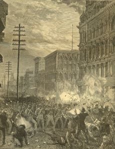
Sixth Regiment fighting railroad strikers, July 20, 1877.
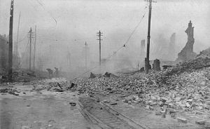
Great Baltimore Fire of 1904, looking West from Pratt and Gay Streets.
The Maryland colonial General Assembly created the Port of Baltimore at Locust Point in 1706 for the tobacco trade. The Town of Baltimore was founded on July 30, 1729. Baltimore grew swiftly in the eighteenth century as a granary for sugar-producing colonies in the Caribbean. The profit from sugar encouraged the cultivation of cane. Baltimore's shorter distance from the Caribbean, compared to other large port cities such as New York City and Boston, reduced transportation time and minimized the spoilage of flour.
Baltimore played a key role in events leading to and during the American Revolution. City leaders moved the city to join the resistance to British taxes and merchants signed agreements to not trade with Britain. After the war, the Town of Baltimore, nearby Jonestown, and an area known as Fells Point were incorporated as the City of Baltimore in 1797. The city remained a part of Baltimore County until 1851 when it was made an independent city.
The city was the site of the Battle of Baltimore during the War of 1812. After burning Washington, D.C., the British attacked Baltimore on the night of September 13, 1814. United State forces from Fort McHenry successfully defended the city's harbor from the British. Francis Scott Key, a lawyer, was aboard a British ship where he had been negotiating for the release of an American prisoner. Key witnessed the bombardment from this ship and later wrote "The Star-Spangled Banner," a poem recounting the attack. Key's poem was set to a 1780 tune by British composer John Stafford Smith, and the "Star-Spangled Banner" became the official national anthem of the United States in 1931.
In the years after the war, the city's population grew rapidly. The construction of the federally funded National Road (presently U.S. Route 40) and the private Baltimore & Ohio Railroad (B&O) made Baltimore a major shipping and manufacturing center by linking the city with major markets in the Midwest.
Maryland did not secede during the Civil War. When Union soldiers marched through the city at the start of the war, Confederate sympathizers attacked the troops, which led to the Baltimore riot of 1861. Four soldiers and 12 civilians were killed during the riot, which caused Union troops to occupy Baltimore. Maryland came under direct federal administration—in part, to prevent the state from seceding—until the end of the war in April 1865.
On February 7, 1904, the Great Baltimore Fire destroyed over 1,500 buildings in 30 hours and forced most of the city to rebuild. The city grew in area by annexing new suburbs from the surrounding counties.
A riot occurred in the city following the assassination of Martin Luther King, Jr. in Memphis, Tennessee, on April 4, 1968, coinciding with riots in other cities. The riot cost the city an estimated $10 million (about $63 million in 2008 dollars). Lasting effects of the riot can be seen on some streets, where long stretches remain barren.
During the 1970s, Baltimore's downtown area, known as the Inner Harbor, had been neglected and was only occupied by a collection of abandoned warehouses. Efforts to redevelop the area began with the construction of the Baltimore Convention Center, which opened in 1979. Harborplace, an urban retail and restaurant complex, opened on the waterfront in 1980, followed by the National Aquarium—Maryland's largest tourist destination—in 1981. In 1992, the Baltimore Orioles baseball team moved to Oriole Park at Camden Yards, located downtown near the harbor. Six years later the Baltimore Ravens football team moved into M&T Bank Stadium next to Camden Yards.
On January 17, 2007, Sheila Dixon became the first female mayor of Baltimore.
Government and politics
Baltimore is an independent city—not part of any county. For most governmental purposes under Maryland law, Baltimore City is treated as a "county"-level entity.
Baltimore has been a Democratic stronghold for over 150 years, with Democrats dominating every level of government.
- Mayor
On November 6, 2007, incumbent Democratic Mayor Sheila Dixon was elected mayor. Dixon, as former City Council president, had assumed the office on January 17, 2007, when former Mayor Martin O'Malley took office as the governor of Maryland.
- Baltimore City Council
Grassroots pressure for reform restructured the city council in November 2002, against the will of the mayor, the council president, and the majority of the council. A coalition of union and community groups backed the effort. The council is now made up of 14 single-member districts and one elected at-large council president.
- State government
Prior to 1969, some considered Baltimore and its suburbs to be underrepresented in the Maryland General Assembly, while rural areas were heavily overrepresented. Since the court decision in Baker v. Carr in 1962, Baltimore and its suburbs account for a substantial majority of seats in the state legislature; this has caused some to argue that rural areas are now underrepresented. Baltimore's steady loss of population, however, has resulted in a loss of seats in the Maryland General Assembly. Since 1980, Baltimore has lost four senators from the 47-member Maryland State Senate and 12 delegates from the 141-member Maryland House of Delegates.
- Federal government
Three of the state's eight congressional districts include portions of Baltimore. All three seats are held by Democrats; a Republican has not represented a significant portion of Baltimore since 1931 and has not represented any of Baltimore since 2003.
Economy
Once an industrial town, with an economic base focused on steel processing, shipping, auto manufacturing, and transportation, Baltimore now has a modern service economy. Although de-industrialization took its toll on the city, costing residents tens of thousands of low-skilled, high-wage jobs, the city is a growing financial, business, and health service base for the southern Mid-Atlantic region. The city is also home to Johns Hopkins Hospital, which will serve as the center of a new biotechnology park, one of two such projects under construction in the city in 2008..
Port of Baltimore

Baltimore harbor in 1849 with the prominent Washington Monument in the background
The port was founded in 1706, preceding the founding of the city. The Maryland colonial legislature made the area near Locust Point the port of entry for the tobacco trade with England. Fells Point, the deepest point in the natural harbor, soon became the colony's main ship building center and later became a leader in the construction of clipper ships. The California Gold Rush led to many orders for fast vessels; many overland pioneers relied upon canned goods from Baltimore. At the end of the nineteenth century, European ship lines had terminals for immigrants. The Baltimore and Ohio Railroad made the port a major transshipment point. Currently the port has major roll-on roll-off facilities, as well as bulk facilities, especially for steel handling.
In 2007, Duke Realty Corporation began a development near the Port of Baltimore, named the Chesapeake Commerce Center. This new industrial park is located on the site of a former General Motors plant. The total project comprises 184 acres (0.74 km²) in eastern Baltimore City and the site will yield 2,800,000 square feet (260,000 m²) of warehouse/distribution and office space. Chesapeake Commerce Center has direct access to two major Interstate Highways (I-95 and I-895) and is located adjacent to two of the major Port of Baltimore Terminals.
Transportation
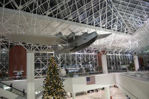
Interior of Baltimore-Washington International Thurgood Marshall Airport, Baltimore's major commercial airport
Two tunnels traverse the Baltimore harbor within the city limits: the four-bore Fort McHenry Tunnel (served by I-95) and the two-bore Harbor Tunnel (served by I-895). The Baltimore Beltway crosses south of Baltimore harbor over the Francis Scott Key Bridge.
Baltimore is a top destination for Amtrak along the Northeast Corridor. Baltimore's Penn Station is one of the busiest in the country. Additionally, the MARC commuter rail service connects the city's two main intercity rail stations, Camden Station and Penn Station, with Washington, D.C.'s Union Station as well as stops in between.
Public transit in Baltimore is provided by the Maryland Transit Administration. The city has a comprehensive bus network, a small light rail network connecting Hunt Valley in the north to the airport in the south, and a subway line between Owings Mills and Johns Hopkins Hospital.
Baltimore is served by Baltimore-Washington International Thurgood Marshall Airport, generally known as "BWI," which lies to the south in neighboring Anne Arundel County. In terms of passengers, BWI airport is the twenty-sixth top airport in the United States.
Demographics
Baltimore was among the top 10 cities in population in the United States in every census up to the 1980 census, and after World War II had a population of nearly a million. The city and metropolitan area currently rank in the top 20 in terms of population. In the 1990s, the Unites States census reported that Baltimore ranked as one of the largest population losers alongside Detroit, Michigan and Washington, D.C., losing over 84,000 residents between 1990 and 2000.[4]
As of 2006, the population was 637,455. The Baltimore–Towson metropolitan area, as of 2004, was estimated to have a population of 2.6 million. The population density was 8,058.4 people per square mile (3,111.5/km²). There were 300,477 housing units at an average density of 3,718.6/sq mi (1,435.8/km²). The racial makeup of the city was 64.85 percent African American, 31.28 percent Caucasian, 0.32 percent Native American, 1.53 percent Asian, 0.03 percent Pacific Islander, 0.67 percent from other races, and 1.47 percent from two or more races. 1.70 percent of the population were Hispanic or Latino of any race. This census, however, does not accurately represent the city's Latino population, which has been steadily increasing in recent decades. [5] 6.2 percent of the population were of German ancestry, according to the 2000 census. About 18.8 percent of families and 22.9 percent of the population were below the poverty line, including 30.6 percent of those under age 18 and 18.0 percent of those ages 65 or over.
Crime
According to crime statistics there were 276 homicides in Baltimore in 2006, the second-highest homicide rate per 100,000 of all United States cities of 250,000 or more population.[6] Though this is significantly lower than the record-high 353 homicides in 1993, the homicide rate in Baltimore is nearly seven times the national rate, six times the rate of New York City, and three times the rate of Los Angeles.
Other categories of crime in Baltimore have also been declining, although overall crime rates are still high compared to the national average. The rate of forcible rapes has fallen below the national average in recent years; however, Baltimore still has much higher-than-average rates of aggravated assault, burglary, robbery, and theft.[7] Baltimore was ranked as the twelfth most dangerous city in the United States in 2008.
City officials have, however, come under scrutiny from Maryland legislators regarding the veracity of crime statistics reported by the Baltimore City Police Department. In 2003, the FBI identified irregularities in the number of rapes reported. The number of homicides in 2005 appeared to exhibit discrepancies as well. However, many of the charges made by the police commission now appear to be politically motivated. Under the administration of Mayor Sheila Dixon and a new police commissioner, crime rates have been reduced, including a 40 percent fall in the number of murders as of April 2008.[8] As of December 3, 2008, the city had had 216 homicides.
Education
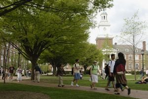
Undergraduates walk across Keyser Quadrangle in Spring at the Johns Hopkins University
Elementary and secondary schools
The Baltimore City Public School System in in charge of the education of approximately 90,000 children. It maintains about 173 schools, including Baltimore City College, the third oldest public high school in the country, and Western High School, the oldest public all-girls school in the nation. Partial control was ceded to the state in exchange for increased funding. The mayor and governor jointly appoint the school board that oversees the system.
Colleges and universities
Baltimore is the home of numerous places of higher learning, both public and private. Among the private schools are Johns Hopkins University, College of Notre Dame of Maryland, and Loyola College in Maryland.
The public colleges include Baltimore City Community College, Coppin State University, Morgan State University, University of Baltimore, and University of Maryland, Baltimore.
Culture
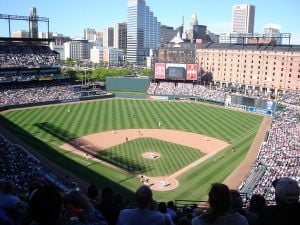
Oriole Park at Camden Yards
Historically a working-class port town, Baltimore has sometimes been dubbed a "city of neighborhoods," with over 300 districts traditionally occupied by distinct ethnic groups. Most notable today are three downtown areas: the Inner Harbor, frequented by tourists due to its hotels, shops, and museums; Fells Point, once a favorite entertainment spot for sailors but now refurbished and gentrified; and Little Italy, located between the other two, where Baltimore's Italian-American community was based. Further inland, Mt. Vernon is the traditional center of cultural and artistic life of the city; it is home to a distinctive Washington Monument, set atop a hill in a nineteenth-century urban square, that predates the more well-known monument in Washington, D.C., by several decades.
As Baltimore's demographics have changed since World War II, its cultural flavor and accents have evolved as well. Today, after decades of out-migration to suburbs beyond its corporate limits and significant in-migration of African Americans from Georgia and the Carolinas, Baltimore has become a majority black city with a significantly changed, but still regionally distinctive, dialect and culture. Recently, neighborhoods such as Federal Hill and Canton have undergone extensive gentrification and have proven to be popular places for young professionals and college students to reside. In addition, Latinos are making their mark, notably in Upper Fells Point.
Baltimore has been home to a successful black middle class and professional community for centuries. Before the Civil War, Baltimore had one of the largest concentrations of free black Americans among American cities. In the twentieth century, Baltimore-born Thurgood Marshall became the first black American justice of the U.S. Supreme Court.
Performing arts
The Baltimore Symphony Orchestra is an internationally renowned orchestra, founded in 1916. Center Stage is the premier theater company in the city and is regionally well respected. The Baltimore Opera is an important regional opera company, and The Baltimore Consort has been a leading early music ensemble for over 25 years. The France-Merrick Performing Arts Center, home of the restored Hippodrome Theatre, has afforded Baltimore the opportunity to become a major regional player in the area of touring Broadway and other performing arts presentations.
Sports
The Baltimore Orioles have represented Major League Baseball locally since 1954, when the St. Louis Browns moved to Baltimore. The Orioles won three World Series Championships in 1966, 1970, and 1983. In 1995, Cal Ripken, Jr. broke Lou Gehrig's "unbreakable" streak of 2,130 consecutive games played. Six former Orioles players have been inducted into the Baseball Hall of Fame.
The Baltimore Ravens have represented the National Football League since 1996. The team has had great success, including a Super Bowl Championship in 2001 and two division championships (2003 and 2006).
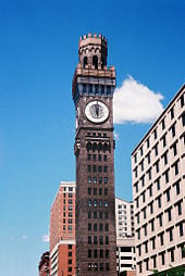 Bromo Seltzer Tower, erected in 1911. |
 Baltimore City College, a public college-preparatory magnet school in Baltimore, the third oldest public high school in the United States. |
Looking to the future
In late 2003, the public school system was discovered to be in a severe fiscal crisis, with a deficit estimated to be anywhere from $54 to $64 million. As a means of reducing the gap, extensive layoffs of teachers and staff took place and new controls were enacted to ensure that spending was more closely monitored. Funding is not the only criterion by which to measure the quality of education provided, but the Baltimore City Public School System is often cited as one of the most under-funded school systems in the state, ranked as twenty-first in overall spending, after falling from fourth approximately 20 years ago. Although economics in Maryland may be an obstacle, alternative approaches and similar initiatives may prove effective.
Some neighborhoods were renovated in the late twentieth and twenty-first centuries and attracted new residents. Other parts of the city languished. East Baltimore contains some of the city's most impoverished neighborhoods. In 2008, the city had 30,000 abandoned properties.
The city's Comprehensive Master Plan aims to capture and encourage biotech job opportunities, create larger tracts of land for commercial or industrial development near transportation centers, and connect residents to available employment. Currently the health, medical, financial, and construction sectors are large and growing. Tourism has long been a strong industry.
The City of Baltimore Development Corporation (BDC) is a 501(c)(3) corporation that contracted with the City of Baltimore to provide economic development services. BDC's goal is to keep existing employers and attract new opportunities. Their work with businesses aims at shepherding private development projects through public processes. BDC facilitates the reuse of publicly owned property for new and expanding businesses.
The 2007 Homeless Census reported that on any given night, at least 3,000 Baltimore city residents sleep on the streets, in shelters, in cars, or other locations. The census found that 1,000 Baltimore citizens meet the federal definition of "chronically homeless," meaning they have been homeless for more than one year or have had at least four episodes of homelessness in three years. To address some of the causes—such as lack of affordable housing, and lack of affordable health care, Baltimore Homeless Services is implemented a 10-year plan to end homelessness by 2018.
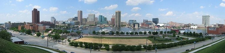
Baltimore's Inner Harbor, seen from Federal Hill. 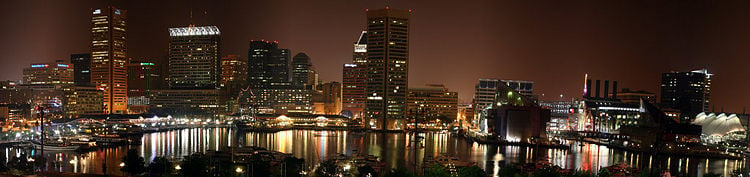
A nighttime panorama of Baltimore's Inner Harbor. Notes
- ↑ USGS detail on Baltimore. Retrieved 2008-12-30.
- ↑ US Census Bureau. Annual Estimates of the Population of Metropolitan and Micropolitan Statistical Areas: 2007.
- ↑ US Census Bureau, Population Finder Baltimore city, Maryland Retrieved December 30, 2008.
- ↑ Pearson Education; Infoplease. Top 50 Cities in the U.S. by Population and Rank. Retrieved December 30, 2008.
- ↑ US Census Bureau. Baltimore city, Maryland Retrieved December 30, 2008.
- ↑
U.S. Department of Justice. Offenses Known to Law Enforcement by State by City, 2006.
- ↑ Area Connect. Baltimore Maryland Crime Statistics and Data Resources Retrieved December 30, 2008.
- ↑ WBAL-TV. March 12, 2008. Baltimore's Murder Rate Retrieved December 30, 2008.
External links
All links retrieved September 17, 2023.
Credits
New World Encyclopedia writers and editors rewrote and completed the Wikipedia article
in accordance with New World Encyclopedia standards. This article abides by terms of the Creative Commons CC-by-sa 3.0 License (CC-by-sa), which may be used and disseminated with proper attribution. Credit is due under the terms of this license that can reference both the New World Encyclopedia contributors and the selfless volunteer contributors of the Wikimedia Foundation. To cite this article click here for a list of acceptable citing formats.The history of earlier contributions by wikipedians is accessible to researchers here:
The history of this article since it was imported to New World Encyclopedia:
Note: Some restrictions may apply to use of individual images which are separately licensed.