Tehran
| Tehran تهران |
|||
| — Capital city — | |||
 |
|||
|
|||
| Country |  Iran Iran
| ||
|---|---|---|---|
| Province | Tehran | ||
| County | Tehran Rey Shemiranat | ||
| District | Central | ||
| Government | |||
| - Mayor | Alireza Zakani | ||
| Area | |||
| - Urban | 750 km² (289.6 sq mi) | ||
| - Metro | 2,235 km² (862.9 sq mi) | ||
| Elevation | 1,040 to 2,040 m (3,412 to 6,692 ft) | ||
| Population (2016 census) | |||
| - Capital city | 8,693,706 | ||
| - Density | 12,052/km² (31,214.5/sq mi) | ||
| - Metro | 14,557,000 (province) | ||
| - Population rank in Iran | 1st | ||
| Time zone | IRST (UTC+03:30) | ||
| Area code(s) | +98 21 | ||
| Climate | BSk | ||
| Website: tehran.ir | |||


Tehran is the capital and largest city of Iran, the capital of Tehran province, and the administrative center for Tehran County and its Central District.
Tehran was first chosen as the capital of Iran in 1786 by Agha Mohammad Khan of the Qajar dynasty; the capital of Iran had been moved several times throughout its long history, with Tehran becoming the 51st. Large-scale construction works began in the 1920s, and Tehran became a destination for mass migrations from all over Iran. Unfortunately, Tehran was at the center of the Iranian Revolution, and experienced major bombing damage during the Iran–Iraq War, the Twelve-Day War, and the 2026 Iran war.
Tehran is home to many historical sites, including the World Heritage Site Golestan Palace of the Qajar dynasty and the Masoudieh, Sa'dabad, Niavaran and Marmar palace complexes of both the Qajar and Pahlavi dynasties. As well as these sites, Tehran also has several modern constructions, including the Azadi Tower, the Milad Tower, and the Tabiat Bridge. Thus, Tehran is a dynamic capital that brilliantly blends its rich imperial heritage with modern urban lifestyle and would attract tourists from around the world if it were returned to being a safe environment free from war.

|
This article contains special characters. Without proper rendering support, you may see question marks, boxes, or other symbols instead of the correct characters. |
Etymology
Various theories on the origin of the name Tehran have been put forward, but its etymology remains problematic. Ahmad Kasravi suggested that the twin terms Tahrān–Šemrān (the latter spelt Šamirān or Šemirān) reflect the contrast between a “warm place” for Tahrān and a “cool place” for Šemirān. He also provided evidence that cities named "Shemiran" were colder than those named "Tehran" or "Kehran." Other theories consider the ancient history of Iranian languages, such as the "Tirgan" and "Tahran" theories, all of which appear conjectural.[1]
History
Archaeological remains from the ancient city of Ray, the oldest existing city in Tehran province, now been absorbed into the metropolitan area of Greater Tehran, suggest that settlement in Tehran dates back over 6,000 years. Agricultural settlements were long established as part of the Central Plateau Culture on local foothills such as that of Cheshme-Ali in northern Ray, which dates back to around 6,000 B.C.E.[1] The establishment of Ray has been attributed to ancient mythological monarchs, and it is also believed that Ray was the seat of a dynasty of Zoroastrian leadership.
Ancient Persian inscriptions and the Avesta (Zoroastrian scriptures), among other sources, attest to the importance of ancient Ray.[2] Ray is also mentioned several times in the Apocrypha.[3] In the Avesta's Videvdat (i, 15), Rhages is mentioned as the 12th sacred place created by Ohrmazd.[2] In Old Persian inscriptions, Rhages appears as a province (Bistun 2, 10–18).
Classical era
Tehran is in the historical Media region in northwestern Iran. By the time of the Median Empire, part of present-day Tehran was a suburb of the prominent Median city of Rhages. From Rhages, Darius I sent reinforcements to his father Hystaspes, who was putting down a rebellion in Parthia (Bistun 3, 1–10).[2] Some Middle Persian texts give Rhages as the birthplace of Zoroaster,[4] although modern historians generally place the birth of Zoroaster in Khorasan province.
Medieval period
In 641, during the reign of the Sasanian Empire, Yazdgerd III issued his last appeal to the nation from Rhages, before fleeing to Khorasan. Rhages was dominated by the Parthian House of Mihran, and Siyavakhsh—the son of Mehran, the son of Bahram Chobin—who resisted the seventh-century Muslim invasion of Iran. Because of this resistance, when the Arabs captured Rhages, they ordered the town destroyed and rebuilt anew by the aristocrat Farrukhzad.
In the ninth century, Tehran was a well-known village, but less so than Rhages, flourishing nearby. Rhages was described in detail by tenth-century Muslim geographers.[2] Despite the interest that Arabian Baghdad displayed in Rhages, the number of Arabs in the city remained insignificant and the population mainly consisted of Iranians of all classes.
The Oghuz Turks invaded Rhages in 1035 and again in 1042, but the city was recovered under the Seljuks and the Khwarezmians. Medieval writer Najm od Din Razi declared the population of Rhages about 500,000 before the Mongol invasion. In the thirteenth century, the Mongols invaded Rhages, laid the city to ruins, and massacred many of its inhabitants. Others escaped to Tehran.
Early modern era

Italian traveler Pietro della Valle passed through Tehran overnight in 1618, and in his memoirs called the city Taheran. English traveler Thomas Herbert entered Tehran in 1627, and mentioned it as Tyroan.
In the early eighteenth century, Karim Khan of the Zand dynasty ordered a palace and a government office built in Tehran, possibly to declare the city his capital; but he later moved his government to Shiraz. The capital was moved several times throughout its long history, with Tehran becoming the 51st.
Tehran was first chosen as the capital of Iran in 1786 by Agha Mohammad Khan of the Qajar dynasty, because of its proximity to Iran's territories in the Caucasus—which were contested in the Russo-Iranian Wars—and to avoid the vying factions of prior ruling Iranian dynasties. He was aware of the loyalties of the inhabitants of former capitals Isfahan and Shiraz to the Safavid and Zand dynasties respectively, and was wary of the power of the local notables in these cities. Thus, he probably viewed Tehran's lack of a substantial urban structure as a blessing, because it minimized the chances of resistance to his rule by the notables and by the general public. After 50 years of Qajar rule, the city still barely had more than 80,000 inhabitants.[5] Up until the 1870s, Tehran consisted of a walled citadel, a roofed bazaar, and the three main neighborhoods of Udlajan, Chale-Meydan, and Sangelaj, where the majority resided.
During the long reign of Naser al-Din Shah (1848-1896), Tehran witnessed Iran's first institute of higher learning, bank, railway line and museum.[6] The Golestan Palace was significantly rebuilt and expanded in 1865 by Haji Ab ol Hasan Mimar Navai, including the Brilliant Hall, the Mirror Hall and the Edifice of the Sun. The city expanded rapidly through multiple development plans. The first development plan in 1855 emphasized traditional spatial structure. The second, under the supervision of Dar al-Fonun in 1878, included new city walls, in the form of a perfect octagon with an area of 19 square kilometers, mimicking the Renaissance cities of Europe.
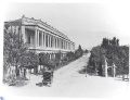
A modern street in Tehran at the end of the nineteenth century.
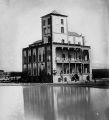
One of Mass'oud Mirza's mansions in Baharestan (district), the late nineteenth century.
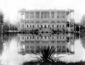
Atabak Park, late nineteenth century.
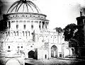
Takyeh Dowlat, a royal theatre near Golestan Palace.


Late modern era

Growing awareness of civil rights resulted in the Constitutional Revolution and the first constitution of Iran in 1906. On June 2, 1907, the parliament passed a law on local governance known as the Baladie (municipal law), providing a detailed outline of issues such as the role of councils within the city, the members' qualifications, the election process, and the requirements to be entitled to vote.
Mohammad Ali Shah abolished the constitution and bombarded the parliament with the help of the Russian-controlled Cossack Brigade on June 23, 1908. That was followed by the capture of the city by the revolutionary forces of Ali-Qoli Khan (Sardar Asad II) and Mohammad Vali Khan (Sepahsalar e Tonekaboni) on July 13, 1909. As a result, the monarch was exiled and replaced by his son Ahmad, and the parliament was re-established.
During the Persian campaign of World War I, Russian forces that were occupying the northwest of Iran marched around Qazvin and approached Tehran, causing a crisis and the dissolution of parliament. Ahmad Shah Qajar and his entourage decided to leave Tehran and move the capital to another place, sparking fears of rebellion in other cities. During the Battle of Robat Karim, Iranian forces led by Heydar Latifiyan prevented the Russians from taking Tehran, despite the latter winning the battle. This also allowed government functions to be moved to Qom and then to Isfahan, while the monarchy remained in Tehran.
Pahlavi era

After World War I, the constituent assembly elected Reza Shah of the Pahlavi dynasty as the new monarch, who immediately suspended the Baladie law of 1907, replacing the decentralized and autonomous city councils with centralist approaches to governance and planning. From the 1920s to the 1930s, under the rule of Reza Shah, the city was rebuilt. Several old buildings, including parts of the Golestan Palace, Takyeh Dowlat, and Toopkhaneh Square, were replaced with modern buildings influenced by classical Iranian architecture, particularly the buildings of the National Bank, the police headquarters, the telegraph office, and the military academy.

Changes to the urban fabric began with the street-widening act of 1933, which served as a framework for changes in all other cities. The Grand Bazaar was divided in half and many historic buildings were demolished and replaced by wide straight avenues,[7] and the traditional texture of the city was replaced with intersecting cruciform streets that created large roundabouts in major public spaces such as the bazaar. As an attempt to create a network for easy transportation within the city, the old citadel and city walls were demolished in 1937, replaced by wide streets cutting through the urban fabric.
During World War II, Tehran was occupied as a result of the Anglo-Soviet invasion of Iran. In 1943, Tehran was the site of the Tehran Conference, attended by U.S. President Franklin D. Roosevelt, Soviet premier Joseph Stalin, and British Prime Minister Winston Churchill.
The establishment of the planning organization of Iran in 1948 resulted in the first socioeconomic development plan covering the period from 1949 to 1955. These plans not only failed to slow the unbalanced growth of Tehran but, with the 1962 land reforms that Reza Shah's son and successor, Mohammad Reza Shah named the White Revolution, Tehran's chaotic growth was further accentuated.
In the 1960s and 1970s, Tehran developed rapidly under Mohammad Reza Shah. Modern buildings altered the face of Tehran, and ambitious projects were planned for the following decades. To resolve the problem of social exclusion, the first comprehensive plan was approved in 1968. The consortium of Iranian architect Abd-ol-Aziz Farmanfarmaian and the American firm of Victor Gruen Associates identified the main problems blighting the city as high-density suburbs, air and water pollution, inefficient infrastructure, unemployment, and rural-urban migration. Eventually, the whole plan was marginalized by the 1979 Revolution and the subsequent Iran–Iraq War.
.jpg)
Tehran's most famous landmark, the Azadi Tower, was built by the order of the Shah in 1971. It was designed by Hossein Amanat, an architect whose design won a competition, combining elements of classical Sasanian architecture with post-classical Iranian architecture. Formerly known as the Shahyad Tower, it was built to commemorate the 2,500th anniversary of the Imperial State of Iran.
Islamic Republic
Following the 1979 Iranian Revolution, Tehran underwent profound transformations in its urban landscape, political structure, and social dynamics. The revolution led to the establishment of the Islamic Republic of Iran, which brought about a shift from a pro-Western monarchy to a theocratic system based on Islamic principles. This change was reflected in various aspects of Tehran's development. Politically, the revolution resulted in the consolidation of power by forces loyal to Ayatollah Ruhollah Khomeini, the leader of the revolution, and the establishment of new governance structures aligned with Islamic ideologies.
During the Iran–Iraq War from 1980 to 1988 and as a part of the War of the cities, Tehran was repeatedly targeted by airstrikes and Scud missile attacks leading to substantial infrastructural damage.
In the Twelve-Day War of June 2025, Tehran was attacked by Israeli airstrikes and, in an unprecedented move, the people of Tehran committed mass evacuations.[8] The city was also under attack during the 2026 Iran war. Tehran suffered extensive destruction: buildings torn open, piles of rubble, and neighborhoods partially devastated.[9]
Geography
The city of Tehran is bounded in the north by the southern end and the highest point of Alborz Mountain Range (Tochal Peak, 3,963m), in the east by a hilly stretch of Alborz (namely, Sorkheh Hesar National Park, part of Khojir National Park and the northeastern badlands), in the southeast by Raga Mountain and in the west and southwest by fertile meadows and many villages, fed by numerous rivers and streams, mainly Karaj and Jajrud.
Topography
Northern Tehran is at the foot of Alborz, starting at an elevation of 1,800 meters (5,900 ft), with many houses and streets on steep slopes and hills. There is a stretch of hills in the middle of the city (which historically divided Tehran and Shemiran) with its highest point at 1,500 meters (4,900 ft). Southwards and westwards of those hills, Tehran is less steep. On the east, there are numerous hills, with the highest point at 1,950 meters (6,400 ft). The southern end of Tehran (Rey) is at 1,100 meters (3,600 ft), next to a single mountain (Raga) at 1,500 meters (4,900 ft).
Climate
Tehran lies at the southern foot of the Alborz Mountains and the northern edge of the Iranian Central Plateau, giving the city a complex climate. According to the Köppen climate classification system, the bulk of metropolitan Tehran is classified as a cold semi-arid (BSk), while lower elevation suburbs and plains (near Mehrābād Airport) verge on a hot semi-arid (BSh) classification. At the same time, the elevated northern districts (such as Shemiran) approach a Mediterranean climate (Csa) type.
The city’s wide elevation range—from approximately 1,100 m above sea level in the southern plains to over 1,800 m in the northern suburbs—yields pronounced topographic micro-climates. The elevation rises up to 2,000 meters (6,600 ft) at the end of Velenjak in northern Tehran.
Northern parts of Tehran tend to be cooler, receive slightly more precipitation (including more snow), and retain more greenery. In contrast, the more open, lower-lying southern sections of the city experience stronger daytime heating, less relief through breezes, and larger temperature differences between day and night. The difference between daily maximum and minimum temperatures (known as diurnal range) can be modest (≈ 10–12 °C) in built-up urban zones but may exceed 15–20 °C in suburbs or peripheral areas during clear, dry nights.
Urban expansion, the “heat-island” effect, and reduced vegetation have contributed to modest upward shifts in mean temperatures, particularly during summer nights. Summers in Tehran are long and dry. Daytime highs often soar to over 35 °C, and during peak heat waves they may approach or even exceed 40 °C. Nighttime minima during midsummer typically hover around 20–25 °C, though cooler nights are common in the northern districts. The dominance of dry summers means that water management and green-space planning carry particular significance for Tehran’s long-term habitability. Winters are cool in central areas but are notably colder in the higher elevations north of the city: daytime highs in January average around 7–9 °C, while overnight lows in the city center fall to near 0–2°C or slightly below and routinely dip below zero in the suburbs and mountain-adjacent zones.
Annual total rainfall for central Tehran averages roughly 230–300 mm. The wet season spans from late autumn through early spring (roughly November to May), while the summer months (June to September) are extremely dry and often see no measurable rainfall. Most precipitation falls from frontal systems moving in from the northwest and through the Alborz range, with occasional convective storms. Snowfall occurs almost every winter, though accumulation in central Tehran is usually brief, while the northern districts and Alborz foothills receive heavier and longer-lasting snow.
Air currents have a great effect on Tehran's weather. The prevailing wind blowing from the west causes the west of Tehran to always be exposed to fresh air. Although this wind brings smoke and pollution from the western industrial areas, its strong wind takes polluted air out of Tehran. The main direction of the prevailing wind is northwest to southeast. Other air currents that blow in the area are:
- Tochal breeze: With the rapid cooling of the Alborz mountain range at night, a local high-pressure center is formed on Mount Tochal. This cold current flows down the mountain because of high pressure. Thus, a gentle breeze blows into the city from the north at night.
- Southern and southeastern regional winds: These winds blow from the desert plains in the hot months of the year.<
- Western winds: these winds are the Westerlies that affect Tehran throughout the year and can be called the prevailing wind.
Demographics
Tehran has been described as a cultural "melting pot," home to diverse ethnic and linguistic groups from all over the country. The present-day dominant language is the Tehrani variety of the Persian language, and the majority of people identify themselves as Persians. Historically the native language of the Tehran–Ray region was not Persian, which is linguistically Southwest Iranian and originates in Fars, but an extinct Persian dialect and Northwestern Iranian language.[10]
Iranian Azeris are the second-largest ethnic group, comprising about 10–15 percent of the population.[11] Other ethnic communities include Mazanderanis, Kurds, Armenians, Georgians, Bakhtyaris, Talysh, Baloch, Assyrians, Arabs, Jews, and Circassians.
There was a drastic change in ethnic-social composition in the early 1980s. After the political, social, and economic consequences of the 1979 Revolution and the years that followed, many Iranian citizens, mostly Tehranis, left Iran. The majority of Iranian emigrations left for the United States, Germany, Sweden, and Canada. With the start of the Iran–Iraq War, a second wave of inhabitants fled the city, especially during the Iraqi air offensives on Tehran. With most major powers backing Iraq at the time, economic isolation gave yet more reason for many inhabitants to leave Tehran and the country. Having left all they had and having struggled to adapt to a new country and build a life, most of them never came back when the war was over. During the war, Tehran received a great number of migrants from the west and the southwest of Iran bordering Iraq.
Religion
The majority of religious Tehrani are officially Twelver Shia Muslims, which has been the main religion since the sixteenth-century Safavid conversion. Other religious communities include followers of the Sunni and Mystic branches of Islam, Christian denominations, Judaism, Zoroastrianism, and the Baháʼí Faith.
There are many religious centers scattered around Tehran, from old to newly built centers, including mosques, churches, synagogues, and Zoroastrian fire temples. Tehran has a very small third-generation Indian Sikh community with a local gurdwara.
Economy
Tehran is the economic center of Iran. A significant proportion of Iran's public-sector workforce and its large industrial firms are located in the city. Most of the remainder of workers are factory workers, shopkeepers, laborers, and transport workers.
Few foreign companies operate in Tehran, because of the government's complex international relations. But before the 1979 Revolution, many foreign companies were active in Iran.[7] Tehran's present-day modern industries include the manufacturing of automobiles, electronics and electrical equipment, weaponry, textiles, sugar, cement, and chemical products. It is also a leading center for the sale of carpets and furniture. The oil refining companies of Pars Oil, Speedy, and Behran are based in Tehran.
The Tehran Stock Exchange, is a full member of the World Federation of Exchanges and a founding member of the Federation of Euro-Asian Stock Exchanges.[12]
Fashion industry
During the Pahlavi era in the mid-1930s, Western fashion was introduced to Iran and greatly influenced women's style. Following the Iranian Revolution in 1979, the hijab became compulsory, impacting the creation of clothing style.
Design, manufacturing, distribution, marketing, retail, advertising, and other sectors of the fashion industry in Tehran have grown significantly. Despite the lack of adequate laws to support models, payments to female models have been considered high. Also, modeling of children is usually prohibited in Tehran. Clothing manufacturers are closely related to other fashion sectors in Tehran.
Ancient Persians used to wear leather high-heeled boots. Both Persian women and men wore varieties of "tall" boots. In the modern era, boots became a main and common footwear among Iranian women, and this influenced the Iranian fashion industry. Iran has become a significant exporter of footwear.
Exhibitions of clothing and related goods are major events in Tehran:
- Iran Mode exhibition (apparel): The first exhibition took place in 2008, marking the beginning of a yearly fashion trade fair in Tehran. The exhibition features around 60 domestic companies showcasing collections inspired by Iranian Islamic culture, in addition to international textile and fashion companies. The exhibition attracts dozens of brands from sectors including women’s, men’s, children’s apparel, accessories, and fabrics.[13]
- Iran MPEX exhibition (footwear, leather, bags).[14]
Shopping
The city has a number of commercial districts, including those located at Valiasr, Davudie, and Zaferanie. Most of the international branded stores and upper-class shops are in the northern and western parts of the city. Tehran's retail business is growing and has a wide range of shopping centers and is home to over 60 modern shopping malls.[15]
The largest old bazaars are the Grand Bazaar and the Bazaar of Tajrish.
Tourism

Tehran, as one of the main tourist destinations in Iran, has a wealth of cultural attractions. It is home to royal complexes of Golestan, Saadabad, and Niavaran, which were built under the reign of the country's last two monarchies. There are several historic, artistic, and scientific museums in Tehran, including:
- National Museum
- Malek Museum
- Cinema Museum at Ferdows Garden
- Abgineh Museum
- Museum of the Qasr Prison
- Carpet Museum
- Reverse Glass Painting Museum (vitray art)
- Safir Office Machines Museum
- Palestine Square Countdown Clock
The Museum of Contemporary Art hosts works of famous artists such as Van Gogh, Pablo Picasso, and Andy Warhol. The Iranian Imperial Crown Jewels, one of the largest jewel collections in the world, are on display at Tehran's National Jewelry Museum. Several cultural and trade exhibitions take place in Tehran, which are mainly operated by the country's International Exhibitions Company. The annual International Book Fair is known to the international publishing world as one of the most important publishing events in Asia and serves as the most significant cultural event in Iran..[16]
Infrastructure
Tehran is served by international and domestic airports, a central railway station, Tehran Metro, the Tehran Bus Rapid Transit system, trolleybuses, and a large network of highways.
Buses
.jpg)
Buses have served the city since the 1920s. Tehran's transport system includes conventional buses, trolleybuses, and bus rapid transit (BRT). The city's four major bus stations include the South Terminal, the East Terminal, the West Terminal, and the northcentral Beyhaghi Terminal.
The trolleybus system was opened in 1992, using a fleet of 65 articulated trolleybuses built by Czech Republic's Škoda. This was the first trolleybus system in Iran.[17]
Tehran's bus rapid transit (BRT) was officially inaugurated in 2008.
Railway and subway

Tehran has a central railway station that connects services round the clock to various cities in the country, along with a Tehran–Europe train line also running. The feasibility study and conceptual planning of the construction of Tehran's subway system were started in the 1970s.
Airports
Tehran is served by the international airports of Mehrabad and Imam Khomeini. Mehrabad Airport, an old airport in western Tehran that doubles as a military base, is mainly used for domestic and charter flights. Imam Khomeini Airport, located 50 kilometers (31 mi) south of the city, handles the main international flights.
Parks and green spaces
There are over 2,000 parks within the metropolis of Tehran, with one of the oldest being Jamshidie Park, which was first established as a private garden for Qajar prince Jamshid Davallu, and was then dedicated to the last empress of Iran, Farah Pahlavi. The total green space within Tehran stretches over 12,600 hectares, covering over 20 percent of the city's area.[18]
Tehran's Birds Garden is the largest bird park in Iran. There is also a zoo located on the Tehran–Karaj Expressway, housing over 290 species within an area of about five hectares.
Environmental issues
Tehran is located near two major fault lines. The city’s wide elevation range—from approximately 1,100 m above sea level in the southern plains to over 1,800 m in the northern suburbs—yields pronounced topographic micro-climates.
Tehran suffers from severe air pollution. City officials are engaged in a battle to reduce air pollution. They have, for instance, encouraged taxis and buses to convert from petrol engines to compressed natural gas. The government has set up a "Traffic Zone" covering the city center during peak traffic hours. Entering and driving inside this zone is only allowed with a special permit. There are efforts to raise people's awareness of the hazards of pollution. Pollution Indicator Boards have been installed all around the city to monitor the level of particulate matter (PM2.5/PM10), nitrogen dioxide (NO2), ozone (O3), sulfur dioxide (SO2), and carbon monoxide (CO).
Because of air pollution, earthquakes, and water scarcity, there have been plans to relocate the capital to another area, although none have been approved.
Education
Tehran is the largest and most important educational center in Iran. There are a total of nearly 50 major colleges and universities in Greater Tehran. Since the establishment of Dar ol Fonun by the order of Amir Kabir in the mid-nineteenth century, Tehran has amassed a large number of institutions of higher education. Some of these institutions have played crucial roles in the unfolding of Iranian political events. Samuel M. Jordan, whom Jordan Avenue in Tehran was named after, was one of the founding pioneers of the American College of Tehran, which was one of the first modern high schools in the Middle East. Tehran is home to Iran's largest military academy and several religious schools and seminaries.
Among major educational institutions located in Tehran, Amirkabir University of Technology (Tehran Polytechnic), University of Tehran, Sharif University of Technology, and Tehran University of Medical Sciences are the most prestigious. Other major universities located in Tehran include Tehran University of Art, Allameh Tabatabaei University, K. N. Toosi University of Technology, Shahid Beheshti University (Melli University), Kharazmi University, Iran University of Medical Sciences, Islamic Azad University, International Institute of Earthquake Engineering and Seismology, Iran's Polymer and Petrochemical Institute, Shahed University, and Tarbiat Modarres University. Sharif University of Technology, Amirkabir University of Technology, Iran University of Science and Technology and K. N. Toosi University of Technology also located in Tehran are nationally well known for taking in the top undergraduate Engineering and Science students; and internationally recognized for training competent undergraduate students. It has probably the highest percentage of graduates who seek higher education abroad.
Culture
Tehran is home to many historical sites, including the World Heritage Site Golestan Palace of the Qajar dynasty and the Masoudieh, Sa'dabad, Niavaran and Marmar palace complexes of both the Qajar and Pahlavi dynasties.
Tehran also has impressive modern structures, including the 435-meter-high Milad Tower, one of the proposed development projects of pre-revolutionary Iran, was completed in 2007 and has become a famous landmark of Tehran. Tabiat Bridge, a 270-meter pedestrian overpass that was designed by award-winning architect Leila Araghian, was completed in 2014.[19] The Azadi Tower is a memorial built in 1971 to mark the 2,500th anniversary of the Persian Empire[20]
Iranian festivals are held in Tehran along with regional and western festivals. Nowruz, Chaharshanbe Suri, Sizdah Be-dar, Yaldā Night, Valentine's Day and Halloween have been popular festivals in recent decades.
Architecture
Despite the regular occurrence of earthquakes during the Qajar period and after, some historic buildings remain from the Qajar and Pahlavi eras. In Greater Tehran, monuments dating back to the Seljuk era remain as well; notably the Toqrol Tower in Ray. Rashkan Castle dates back to the ancient Parthian Empire. Various war artifacts discovered at the site are now displayed in the National Museum of Iran.[21]
Tehran is Iran's primate city, and is considered to have the most modernized infrastructure in the country. However, the gentrification of old neighborhoods and the demolition of buildings of cultural significance have caused concerns.[22]
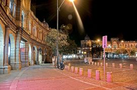
Hasanabad Square
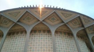
City Theater of Tehran
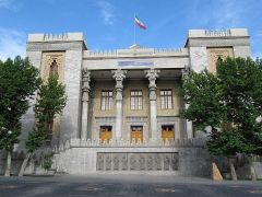
Iran's Ministry of Foreign Affairs
National Garden


Tehran was previously a low-rise city because of seismic activity in the region, but modern high-rise developments have been built in recent decades to service its growing population. There have been no major quakes in Tehran since 1830. Tehran International Tower is the tallest skyscraper in Iran. It is 54-stories tall and located in the northern district of Yusef Abad. The Azadi Tower, a memorial built under the reign of the Pahlavi dynasty, has long been the most famous symbol of Tehran. Originally constructed in commemoration of the 2,500th year of the foundation of the Imperial State of Iran, it combines elements of the architecture of the Achaemenid and Sassanid eras with post-classical Iranian architecture. The Milad Tower is the city's other famous landmark tower. Leila Araghian's Tabiat Bridge, the largest pedestrian overpass in Tehran, is also considered a landmark.[19]
Food

There are many restaurants and cafes in Tehran, both modern and classic, serving both Iranian and cosmopolitan cuisine. Pizzerias, sandwich bars, and kebab shops make up the majority of food shops in Tehran.[23]
Theater

Under the reign of the Qajars, Tehran was home to the royal theatre of Tekye Dowlat, located to the southeast of the Golestan Palace, in which traditional and religious performances were observed. It was eventually demolished and replaced with a bank building in 1947, following the reforms during the reign of Reza Shah.
Before the 1979 Revolution, the Iranian national stage had become the most famous performing scene for known international artists and troupes in the Middle East,[24] with the Vahdat Hall, formerly and still known as Rudaki Hall), constructed to function as the national stage for opera and ballet. The hall was inaugurated in October 1967 and named after prominent Persian poet Rudaki. It is home to the Tehran Symphony Orchestra, the Tehran Opera Orchestra, and the Iranian National Ballet Company.
The City Theater of Tehran, one of Iran's biggest theatre complexes, which contains several performance halls, was opened in 1972. It was built at the initiative and presidency of Empress Farah Pahlavi, and was designed by architect Ali Sardar Afkhami.
One of the gathering centers of cabarets in old Tehran was Laleh-Zar Street. Famous Persian cabarets were active in the city until 1979. They also introduced many domestic artists.
The annual events of Fajr Theater Festival and Tehran Puppet Theater Festival take place in Tehran.
Cinema
The first movie theater in Tehran was established by Mirza Ebrahim Khan in 1904.[25] The complexes of Kourosh Cinema, Mellat Gallery and Cineplex, Azadi Cinema, and Cinema Farhang are among the most popular cinema complexes in Tehran.
Several film festivals are held in Tehran, including Fajr Film Festival, Children and Youth Film Festival, House of Cinema Festival, Mobile Film and Photo Festival, Nahal Festival, Roshd Film Festival, Tehran Animation Festival, Tehran Short Film Festival, and Urban Film Festival.
Graffiti
Many styles of graffiti are seen in Tehran. Some are political and revolutionary slogans painted by governmental organizations,[26] and some are works of art by ordinary citizens, representing their views on both social and political issues. However, unsanctioned street art is forbidden in Iran, and such works are usually short-lived.[26]
Sports
Football and volleyball are the city's most popular sports, while wrestling, basketball, and futsal (a scaled-down variant of association football) are also major parts of the city's sporting culture. Ice hockey and rugby are also popular. A number of ski resorts operate in Iran, the most famous being Tochal, Dizin, and Shemshak, all within one to three hours from the city of Tehran.
Tehran is the site of the national stadium of Azadi, where many of the top matches of Iran's Premier League are held. The stadium is a part of the Azadi Sport Complex, which was originally built to host the 7th Asian Games in September 1974. This was the first time the Asian Games were hosted in West Asia. That followed hosting the 6th AFC Asian Cup in June 1976, and then the first West Asian Games in November 1997. The city also hosted the final of the 1968 AFC Asian Cup. Several FIVB Volleyball World League courses have also been hosted in Tehran. In 2014, the city hosted the FILA Wrestling World Cup event at the Azadi Indoor Stadium.

Iran's ice hockey league in Tehran
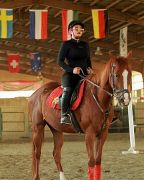
Horse riding in the west of the city
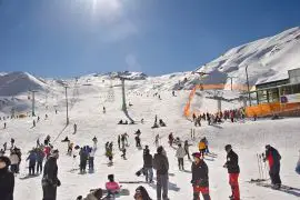
Dizin, Iran's largest ski resort, is located near Tehran.

_5.jpg)

Notes
- ↑ 1.0 1.1 Xavier De Planhol, Tehran: A Persian City at the Foot of the Alborz Encyclopedia Iranica, July 20, 2004. Retrieved June 23, 2026.
- ↑ 2.0 2.1 2.2 2.3 Vladimir Minorsky and Clifford E. Bosworth, The Encyclopaedia of Islam (Leiden: E. J. Brill, 1998, ISBN 978-9004081185).
- ↑ Judith 1:5, 15; Tobit 1:14, 5:5, 6:10.
- ↑ Vesta Sarkhosh Curtis and Sarah Stewart (eds.), Birth of the Persian Empire (I.B. Tauris, 2005, ISBN 978-1845110628), 37.
- ↑ Abbas Amanat, Pivot of the Universe: Nasir Al-Din Shah Qajar and the Iranian Monarchy, 1831–1896 (I.B. Tauris, 2008, ISBN 978-1845118280).
- ↑ John Scott-Keltie (ed.), The Statesman's Year-Book (Legare Street Press, 2023, ISBN 978-1021346292).
- ↑ 7.0 7.1 Mohammad A. Chaichian, Town and Country in the Middle East: Iran and Egypt in the Transition to Globalization (Lexington Books, 2008, ISBN 978-0739126776).
- ↑ Parisa Hafezi, Iranians flee capital for safety as Israeli airstrikes intensify Reuters, June 16, 2025. Retrieved June 23, 2026.
- ↑ Golnar Motevalli, Krishna Karra, Tom Fevrier, and Raeedah Wahid, Satellite Data Reveal Scope and Scale of US-Israeli Strikes on Iran Bloomberg, April 21, 2026. Retrieved June 23, 2026.
- ↑ Gernot L. Windfuhr, Central Dialects Encyclopædia Iranica, May 31, 2013. Retrieved June 24, 2026.
- ↑ International Business Publications, Iran: A Country Study Guide (International Business Publications, 2005, ISBN 978-0739714768)
- ↑ Iran blocks share price gains BBC, August 6, 2003. Retrieved June 24, 2026.
- ↑ The 11th International Iran Apparel Exhibition ExpoBook. Retrieved June 25, 2026.
- ↑ Surge in PU output helped Iran become shoe exporter Mehr News Agency, August 21, 2024. Retrieved June 25, 2026.
- ↑ Hopes for shopping revolution as malls sprout in Iran Gulf News, September 15, 2018. Retrieved June 24, 2026.
- ↑ About Tibf Tehran International Book Fair. Retrieved June 24, 2026.
- ↑ Alan Murray, World Trolleybus Encyclopaedia (British Trolleybus Society, 2000, ISBN 978-0904235180).
- ↑ Mokhtari: There are over 2,100 parks in Tehran Islamic Republic News Agency (IRNA), February 15, 2015. Retrieved June 25, 2026.
- ↑ 19.0 19.1 Tabiat Pedestrian Bridge / Diba Tensile Architecture ArchDaily, November 17, 2014. Retrieved June 26, 2026.
- ↑ Hossein Amanat, Azadi Tower BeGlobality. Retrieved June 26, 2026.
- ↑ Rashkan Castle Around Us. Retrieved June 26, 2026.
- ↑ Donna Urschel, The Style of Tehran Library of Congress Information Bulletin, August, 2004. Retrieved June 26, 2026.
- ↑ Tehran Food Guide The City Lane, July 27, 2015. Retrieved June 26, 2026.
- ↑ Nima Kiann, "The History of Ballet in Iran" in Dance in Iran: Past and Present edited by Saloumeh Gholami (Reichert Verlag, 2016, ISBN 978-3954901968).
- ↑ Massoud Mehrabi, The history of Iranian cinema. Retrieved June 26, 2026.
- ↑ 26.0 26.1 Cheragh Abadi, Mehrnoush. (10 February 2017). The fleeting freedom of street art in Tehran. Equal Times.
ReferencesISBN links support NWE through referral fees
- Amanat, Abbas. Pivot of the Universe: Nasir Al-Din Shah Qajar and the Iranian Monarchy, 1831–1896. I.B. Tauris, 2008. ISBN 978-1845118280
- Chaichian, Mohammad A. Town and Country in the Middle East: Iran and Egypt in the Transition to Globalization. Lexington Books, 2008. ISBN 978-0739126776
- Curtis, Vesta Sarkhosh, and Sarah Stewart (eds.). Birth of the Persian Empire. I.B. Tauris, 2005. ISBN 978-1845110628
- Gholami, Saloumeh (ed.). Dance in Iran: Past and Present. Reichert Verlag, 2016. ISBN 978-3954901968
- International Business Publications. Iran: A Country Study Guide. International Business Publications, 2005. ISBN 978-0739714768
- Minorsky, Vladimir, and Clifford E. Bosworth. The Encyclopaedia of Islam. Leiden: E. J. Brill, 1998. ISBN 978-9004081185
- Murray, Alan. World Trolleybus Encyclopaedia. British Trolleybus Society, 2000. ISBN 978-0904235180
- Scott-Keltie, John (ed.). The Statesman's Year-Book. Legare Street Press, 2023. ISBN 978-1021346292
- Zoka, Yahya. Karvand of Kasravi. Franklin, 1978.
External links
All links retrieved June 26, 2026.
- Google Map: Tehran
- Tehran Times
- General Information about Tehran Qatar Embassy in Tehran
- Tehran Lonely Planet
Credits
New World Encyclopedia writers and editors rewrote and completed the Wikipedia article in accordance with New World Encyclopedia standards. This article abides by terms of the Creative Commons CC-by-sa 3.0 License (CC-by-sa), which may be used and disseminated with proper attribution. Credit is due under the terms of this license that can reference both the New World Encyclopedia contributors and the selfless volunteer contributors of the Wikimedia Foundation. To cite this article click here for a list of acceptable citing formats.The history of earlier contributions by wikipedians is accessible to researchers here:
The history of this article since it was imported to New World Encyclopedia:
Note: Some restrictions may apply to use of individual images which are separately licensed.

