Zhejiang
| 浙江省 Zhèjiāng Shěng | |
| Abbreviations: 浙 (Pinyin: Zhè) | |

| |
| Origin of name | Old name of Qiantang River |
| Administration type | Province |
| Capital (and largest city) |
Hangzhou |
| CPC Ctte Secretary | Zhao Hongzhu |
| Governor | Lu Zushan |
| Area | 101,800 km² (25th) |
| Population (2004) - Density |
47,200,000 (11th) 464/km² (8th) |
| GDP (2006) - per capita |
CNY 1.56 trillion (4th) CNY 31,684 (4th) |
| HDI (2005) | 0.817 (high) (4th) |
| Major nationalities | Han - 99.2% She - 0.4% |
| Prefecture-level | 11 divisions |
| County-level | 90 divisions |
| Township-level† | 1570 divisions |
| ISO 3166-2 | CN-33 |
| Official website http://www.zhejiang.gov.cn (Simplified Chinese) | |
| Source for population and GDP data: 《中国统计年鉴—2005》 China Statistical Yearbook 2005 Source for nationalities data:ISBN 7503747382 《2000年人口普查中国民族人口资料》 Tabulation on nationalities of 2000 population census of China † As at December 31, 2004
ISBN 7105054255 | |
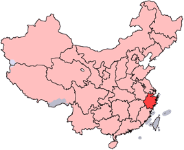
Zhejiang (Chinese: 浙江; pinyin: Zhèjiāng) is a province of the People's Republic of China located along the country's southeastern coast. It borders Jiangsu province and Shanghai municipality to the north, Anhui province to the northwest, Jiangxi province to the west, and Fujian province to the south. To its east is the East China Sea and even further east lies the Ryukyu Islands of Japan.
The word Zhejiang (meaning "crooked river") was the old name of the Qiantang River that passes through Hangzhou, the provincial capital. The name of the province is often abbreviated to "Zhe" (浙).
History
Zhejiang was outside the sphere of influence of early Chinese civilization during the Shang Dynasty, which lasted from the sixteenth century to the eleventh century B.C.E.. Instead, it was largely populated by peoples collectively known as the Yue, such as the Dongyue and the Ouyue. Starting from the Spring and Autumn Period, a state of Yue emerged in northern Zhejiang that was heavily influenced by the Chinese civilization further north. Under King Goujian of Yue it reached its zenith and was able to wipe out the state of Wu, a major power at the time in 473 B.C.E. In 333 B.C.E., this state was conquered by the state of Chu that controlled the area to the west of Zhejiang, and ultimately the state of Qin was able to subjugate all the states of China under its control in 221 B.C.E., thereby establishing the first unified Chinese empire.
Throughout the Qin Dynasty (221 to 206 B.C.E.) and Han Dynasty (206 B.C.E. to 220 C.E.), Zhejiang was under the control of the unified Chinese state, though it was mostly considered a frontier area. Southern Zhejiang was under minimal control of that state, since it was still inhabited by Yue peoples with their own political and social structures. Near the end of the Han Dynasty, Zhejiang became home to minor warlords such as Yan Baihu and Wang Lang, who fell in turn to Sun Ce and Sun Quan, the two leaders who eventually established the Kingdom of Wu (222-280), one of the Three Kingdoms.
From the fourth century onwards, China was subject to repeated invasions from the north by nomadic peoples, who conquered areas of North China and established the Sixteen Kingdoms and the Northern Dynasties. The result was a massive influx of refugees that arrived from the north and poured into South China, which hosted the refugee Eastern Jin Dynasty and Southern Dynasties. This large transfer of population accelerated the sinicization of South China, including Zhejiang.
The link between Zhejiang and the center of Chinese civilization was further enhanced when the Sui Dynasty reestablished unity and built the Grand Canal of China, which linked Hangzhou to the North China Plain. Later on, the Tang Dynasty (618-907) presided over a golden age of China, and Zhejiang was a part of their Jiangnandong Circuit, an area which began to appear experience increasing prosperity. As the Tang Dynasty disintegrated, Zhejiang constituted most of the territory of the regional kingdom of Wuyue, which grew in its place.
The Northern Song Dynasty re-established unity of all of China around 960. Under the Song Dynasty, the prosperity of South China began to overtake North China. After the north was lost to the Jurchens in 1127, Zhejiang began to experience tremendous economic growth. Its modern provincial capital, Hangzhou, was the capital of the Han Chinese Southern Song Dynasty which held on to most of the area of South China. Renowned for its prosperity and beauty, it may have been the largest city in the world at the time. [1] Ever since then, north Zhejiang together with neighboring south Jiangsu has been synonymous with luxury and opulence in Chinese culture. Mongol conquest and the establishment of the Yuan Dynasty in 1279 ended Hangzhou's reign as the most important city in China politically, but it still continued to prosper. At one point, Marco Polo visited the city, (which he called "Kinsay,"), and referred to it as the "finest and noblest city" in the world." [2]

The Ming Dynasty which eventually drove out the Mongols in 1368 were the first to establish Zhejiang as a full-fledged province, and its borders have not experienced drastic change since that time.
After the People's Republic of China took control of the Chinese mainland in 1949, the government of the Republic of China based in Taiwan continued to control the Dachen Islands off the coast of Zhejiang until 1955. They established a rival Zhejiang provincial government there, which has created a situation similar to Fujian province, whereby each of the governments (both the PRC and Taiwan) have established their own province with the same name.
Geography
Zhejiang consists mostly of hills, which account for about 70% of its total area. Altitudes tend to be highest to the south and west, and the highest peak of the province, Huangyajian Peak (1921 m), is found in the southwest. Mountain ranges include the Yandang Mountains, Tianmu Mountains, Tiantai Mountains, and Mogan Mountains, which traverse the province at altitudes of about 200 to 1000 m.
Valleys and plains are found along the coastline and rivers. The north of the province is just south of the Yangtze Delta, and consists of plains around the cities of Hangzhou, Jiaxing, and Huzhou, where the Grand Canal of China enters from the northern border to end at Hangzhou; another relatively flat area is found along the Qujiang River, around the cities of Quzhou and Jinhua. Major rivers include the Qiantang River and the Oujiang River. Most rivers carve out valleys in the highlands, with plenty of rapids and other features associated with such topography. Famous lakes include the West Lake of Hangzhou and the South Lake of Jiaxing.
There are over three thousand islands along the ragged coastline of Zhejiang. The largest, Zhoushan Island, is Mainland China's third largest island, after Hainan and Chongming. There are also many bays, Hangzhou Bay being the largest.
Zhejiang has a humid subtropical climate with four distinct seasons. Spring starts in March and is rainy and weather is changeable. Summer, from June to September is long, hot and humid. Fall is generally dry, warm and sunny. Winters are short but cold except in the far south. Average annual temperature is around 15 to 19°C, average January temperature is around 2 to 8°C, and average July temperature is around 27 to 30°C. Annual precipitation is about 1000 to 1900 mm. There is plenty of rainfall in early summer, and by late summer Zhejiang is directly threatened by typhoons forming in the Pacific.
Major cities:
- Hangzhou
- Haining
- Ningbo
- Jiaxing
- Huzhou
- Wenzhou
- Shaoxing
- Zhoushan
- Yiwu
- Taizhou
Administrative divisions
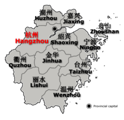
Zhejiang is divided into eleven prefecture-level divisions, all of them prefecture-level cities:
- Hangzhou (Simplified Chinese: 杭州市, Hanyu Pinyin: Hángzhōu Shì)
- Huzhou (湖州市 Húzhōu Shì)
- Jiaxing (嘉兴市 Jiāxīng Shì)
- Zhoushan (舟山市 Zhōushān Shì)
- Ningbo (宁波市 Níngbō Shì)
- Shaoxing (绍兴市 Shàoxīng Shì)
- Quzhou (衢州市 Qúzhōu Shì)
- Jinhua (金华市 Jīnhuá Shì)
- Taizhou (台州市 Tāizhōu Shì) not tái
- Wenzhou (温州市 Wēnzhōu Shì)
- Lishui (丽水市 Líshuǐ Shì) not lì
The eleven prefecture-level divisions of Zhejiang are subdivided into 90 county-level divisions (32 districts, 22 county-level cities, 35 counties, and one autonomous county). Those are in turn divided into 1570 township-level divisions (761 towns, 505 townships, 14 ethnic townships, and 290 subdistricts).
Economy
The province is traditionally known as the "Land of Fish and Rice." True to its name, rice is the main crop, followed by wheat; north Zhejiang is also a center of aquaculture in China, and the Zhoushan fishery is the largest fishery in the country. Main cash crops include jute and cotton, and the province also leads the provinces of China in tea production (the renowned Longjing tea is a product of Hangzhou). Zhejiang is also a producer of silk, for which it is ranked second among the provinces.
Zhejiang's manufacturing is centered upon electromechanical industries, textiles, chemical industries, food, and construction materials. In recent years Zhejiang has followed its own development model, dubbed the "Zhejiang model," which is based on prioritizing and encouraging entrepreneurship, an emphasis on small businesses responsive to the whims of the market, large public investments into infrastructure, and the production of low cost goods in bulk for both domestic consumption and export. As a result, Zhejiang has made itself one of the richest provinces, and the "Zhejiang spirit" has become something of a legend within China. However, some economists are now worrying that this model is not sustainable, in that it is inefficient and places unreasonable demands on raw materials and public utilities, and also a dead end, in that the myriad small businesses of Zhejiang producing cheap goods in bulk are unable to move to more sophisticated or technologically-oriented industries.
Ningbo, Wenzhou, Taizhou and Zhoushan are important commercial ports. The Hangzhou Bay Bridge is being constructed between Haiyan County and Cixi; once complete, it will be the longest sea-crossing bridge in the world.
The per capita disposable income of urbanites in Zhejiang reached 18,265 yuan (US$2,291) in 2006, an annual real growth of 10.4%. The per capita pure income of rural residents stood at 7,335 yuan, a real growth of 6.4% year-on-year [3]. Its nominal GDP for 2006 was 1.565 trillion yuan (US$196 billion) with a per capita of US$3,975 [4]. In 2005, Zhejiang's primary, secondary, and tertiary industries were worth 87.3 billion yuan (US$10.8 billion), 714.7 billion yuan (US$88.1 billion), and 534.5 billion yuan (US$65.9 billion) respectively. [5] [6] [7]
South Zhejiang is mountainous and ill-suited for farming, and has traditionally been poor and underdeveloped. The economic reforms of Deng Xiaoping, however, have brought change to that region unparalleled across the rest of China. Driven by hard work, an entrepreneuring spirit, low labour costs, and an eye for the world market, south Zhejiang (especially cities such as Wenzhou and Yiwu) has become a major center of export. This, together with the traditional prosperity of north Zhejiang, has allowed Zhejiang to leapfrog over several other provinces and become one of the richer provinces of China.
Demographics
Han Chinese make up the vast majority of the population. The She and Hui nationalities are the two largest minorities.
Education
Colleges and universities
- China Academy of Art (中国美术学院) (Hangzhou)
- Hangzhou Dianzi University (杭州电子科技大学) (Hangzhou)
- Hangzhou Normal University (杭州师范大学)(Hangzhou)
- Ningbo University (宁波大学) (Ningbo)
- University of Nottingham, Ningbo, China (诺丁汉大学宁波校区) (Ningbo)
- Zhejiang University (浙江大学) (Hangzhou)
- Zhejiang University of Technology (浙江工业大学) (Hangzhou)
- Zhejiang Normal University (浙江师范大学) (Jinhua)
- Zhejiang University of Finance and Economics (浙江财经学院) (Hangzhou)
- Zhejiang Gongshang University (浙江工商大学)(Hangzhou)
Culture
Zhejiang is mountainous and has therefore fostered the development of many individual localized cultures. Linguistically speaking, Zhejiang is extremely diverse. The inhabitants of Zhejiang speak Wu, a subdivision of spoken Chinese, but the Wu dialects are very diverse, especially in the south, where one valley may speak a dialect completely unintelligible to another valley a few kilometers away. Non-Wu dialects are spoken as well, mostly along the borders; Mandarin and Hui dialects are spoken on the border with Anhui, while Min dialects are spoken on the border with Fujian. (See Hangzhou dialect, Shaoxing dialect, Ningbo dialect, Wenzhou dialect, Taizhou (Zhejiang) dialect, Jinhua dialect, Quzhou dialect for more information). In addition, Standard Chinese (Putonghua/Mandarin) is also spoken by most people.
Zhejiang is the home of Yueju (越劇), one of the most prominent forms of Chinese opera. Yueju originated in Shengzhou and is traditionally performed by actresses only, in both male and female roles. Other important opera traditions include Yongju (of Ningbo), Shaoju (of Shaoxing), Ouju (of Wenzhou), Wuju (of Jinhua), Taizhou Luantan (of Taizhou) and Zhuji Luantan (of Zhuji).
Longjing tea (also called dragon well tea), originating in Hangzhou, is one of the most prestigious, if not the most prestigious Chinese tea. Hangzhou is also renowned for its silk umbrellas and folding fans. Zhejiang cuisine (itself subdivided into many traditions, including Hangzhou cuisine) is one of the eight great traditions of Chinese cuisine.
Since ancient times, north Zhejiang and neighbouring south Jiangsu have been famed for their prosperity and opulence, and simply inserting north Zhejiang place names (Hangzhou, Jiaxing, etc.) into poetry gave an effect of dreaminess, as was indeed done by many famous poets. In particular, the fame of Hangzhou (as well as Suzhou in neighbouring Jiangsu province) has led to the popular saying: 上有天堂,下有苏杭 (above there is heaven; below there is Suzhou and Hangzhou), a saying that continues to be a source of pride for the people of these two still prosperous cities.
Tourism
Tourist destinations in Zhejiang include:
- Baoguo Temple, the oldest intact wooden structure in Southern China, 15km north of Ningbo.
- Putuo Shan, one of the most famous Buddhist mountains of China. Chinese Buddhists associate it with Guan Yin.
- Qita Temple, Ningbo.
- Shaoxing, Wuzhen and other waterway towns.
- The ancient capital of Hangzhou.
- Tiantai Shan, a mountain important to Zen Buddhism.
- West Lake, in Hangzhou
- Yandang Shan, a mountainous scenic area north of Wenzhou.
- Qiandao Lake, lit. Thousand-island lake.
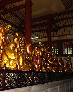
- Guoqing Temple - founded in the Sui Dynasty, the founding place of Tiantai Buddhism
Miscellaneous topics
Media
The Zhejiang Radio & Television, Hangzhou Radio & Television Group, Ningbo Radio & Television Group are the local broadcasters in Zhejiang Province. Programs are produced by Guinness of China Television and entertainment is produced by Wenzhou Television.
Sports
Professional sports teams based in Zhejiang include:
- Chinese Football Association Jia League
- Zhejiang Lücheng
- Chinese Basketball Association
- Zhejiang Cyclones
- Bayi Rockets (in Ningbo)
External links
- 中国浙江省人民政府门户网站 Zhejiang Provincial Government Retrieved November 24, 2007.
- Large map of Zhejiang Retrieved November 24, 2007.
- Overview of Zhejiang Retrieved November 24, 2007.
- UNESCAP Retrieved November 24, 2007.
- Zhejiang travel guide Retrieved November 24, 2007.
| Province-level divisions administered by the People's Republic of China (PRC) | |
|---|---|
| Provinces | Anhui · Fujian · Gansu · Guangdong · Guizhou · Hainan · Hebei · Heilongjiang · Henan · Hubei · Hunan · Jiangsu · Jiangxi · Jilin · Liaoning · Qinghai · Shaanxi · Shandong · Shanxi · Sichuan · Taiwan · Yunnan · Zhejiang |
| Autonomous regions | Guangxi · Inner Mongolia · Ningxia · Tibet (Xizang) · Xinjiang |
| Municipalities | Beijing · Chongqing · Shanghai · Tianjin |
| Special administrative regions | Hong Kong · Macau |
Prefecture-level divisions of Zhejiang
| ||||
| List of Zhejiang County-level divisions |
Credits
New World Encyclopedia writers and editors rewrote and completed the Wikipedia article in accordance with New World Encyclopedia standards. This article abides by terms of the Creative Commons CC-by-sa 3.0 License (CC-by-sa), which may be used and disseminated with proper attribution. Credit is due under the terms of this license that can reference both the New World Encyclopedia contributors and the selfless volunteer contributors of the Wikimedia Foundation. To cite this article click here for a list of acceptable citing formats.The history of earlier contributions by wikipedians is accessible to researchers here:
The history of this article since it was imported to New World Encyclopedia:
Note: Some restrictions may apply to use of individual images which are separately licensed.


