|
|
| (72 intermediate revisions by 5 users not shown) |
| Line 1: |
Line 1: |
| − | {{ready}}{{images OK}} | + | {{Submitted}}{{images OK}}{{Approved}}{{copyedited}} |
| − | {{US state | | + | {{Infobox U.S. state |
| − | Name = Delaware |
| + | | Name = Delaware |
| − | Fullname = State of Delaware |
| + | | Fullname = State of Delaware |
| − | Flag = Flag of Delaware.svg |
| + | | Flag = Flag of Delaware.svg |
| − | Flaglink = [[Flag of Delaware]] |
| + | | Flaglink = [[Flag of Delaware|Flag]] |
| − | Seal = Delaware state seal.png|
| + | | Seal = Delaware state seal.png |
| − | Map = Map of USA DE.svg |
| + | | Map = Map of USA DE.svg |
| − | Motto = Liberty and Independence |
| + | | Motto = Liberty and Independence |
| − | Nickname = The First State, The Small Wonder, Blue Hen State |
| + | | Demonym = Delawarean |
| − | Capital = [[Dover, Delaware|Dover]] |
| + | | Nickname = The First State; The Small Wonder;<br/>Blue Hen State; The Diamond State |
| − | LargestCity = [[Wilmington, Delaware|Wilmington]] |
| + | | Former = Delaware Colony |
| − | Governor = [[Ruth Ann Minner]] (D)| | + | | Capital = [[Dover, Delaware|Dover]] |
| − | Senators = [[Joe Biden|Joseph R. Biden, Jr.]] (D)<br />[[Thomas R. Carper]] (D) |
| + | | LargestCity = [[Wilmington, Delaware|Wilmington]] |
| − | US Representative = [[Michael Castle]](R)|
| + | | LargestMetroArea = [[Wilmington, Delaware|Wilmington]] |
| − | PostalAbbreviation = DE |
| + | | LargestCounty = [[Sussex County, Delaware|Sussex]] |
| − | TradAbbreviation = Del. |
| + | | Governor = [[Jack A. Markell]] ([[Democratic Party (United States)|D]]) |
| − | OfficialLang = English |
| + | | Lieutenant Governor = [[Matthew P. Denn]] (D) |
| − | AreaRank = 49<sup>th</sup> |
| + | | Legislature = [[Delaware General Assembly|General Assembly]] |
| − | TotalArea = 6,452 |
| + | | Upperhouse = [[Delaware Senate|Senate]] |
| − | TotalAreaUS = 2,490 |
| + | | Lowerhouse = [[Delaware House of Representatives|House of Representatives]] |
| − | LandArea = 5,068 |
| + | | Senators = [[Thomas R. Carper]] (D)<br />[[Chris Coons]] (D) |
| − | LandAreaUS = 1,954 |
| + | | Representative = [[John C. Carney, Jr.]] ([[Democratic Party (United States)|D]]) |
| − | Landmark = Holy Trinity Church
| + | | PostalAbbreviation = DE |
| − | WaterArea = 1,387 |
| + | | TradAbbreviation = Del. |
| − | WaterAreaUS = 536 |
| + | | AreaRank = 49th |
| − | PCWater = 21.5 |
| + | | TotalArea = 6,452 |
| − | PopRank = 45<sup>th</sup> |
| + | | TotalAreaUS = 2,490 |
| − | 2000Pop = 783,600 |
| + | | LandArea = 5,068 |
| − | DensityRank = 7<sup>th</sup> |
| + | | LandAreaUS = 1,954 |
| − | 2000Density = 154.87 |
| + | | Landmark = Holy Trinity Church |
| − | 2000DensityUS = 401.11 |
| + | | WaterArea = 1,387 |
| − | MedianHouseholdIncome = $50,152 |
| + | | WaterAreaUS = 536 |
| − | IncomeRank = 12<sup>th</sup> |
| + | | PCWater = 21.5 |
| − | AdmittanceOrder = 1<sup>st</sup> |
| + | | PopRank = 45th |
| − | AdmittanceDate = December 7, 1787 |
| + | | 2000Pop = 907,135 (2011 est)<ref name=PopEstUS>{{cite web|title=Annual Estimates of the Resident Population for the United States, Regions, States, and Puerto Rico: April 1, 2010 to July 1, 2011|format=[[comma-separated values|CSV]]|work=2011 Population Estimates|publisher=[[United States Census Bureau]], Population Division|date=December 2011}}</ref> |
| − | TimeZone = [[Eastern Standard Time Zone|Eastern]]: [[Coordinated Universal Time|UTC]]-5/[[Daylight saving time|-4]] |
| + | | DensityRank = 6th |
| − | Longitude = 75° 3′ W to 75° 47′ W |
| + | | 2000Density = 179 |
| − | Latitude = 38° 27′ N to 39° 50′ N |
| + | | 2000DensityUS = 464 |
| − | Width = 48 |
| + | | MedianHouseholdIncome = $50,152 |
| − | WidthUS = 30 |
| + | | IncomeRank = 12th |
| − | Length = 154 |
| + | | AdmittanceOrder = 1st |
| − | LengthUS = 96 |
| + | | AdmittanceDate = December 7, 1787 |
| − | HighestPoint = near [[Ebright Azimuth]]<ref name=udel>[http://www.udel.edu/dgs/Publications/pubsonline/info8.html Delaware Geological Survey] - Retrieved December 13, 2007.</ref> |
| + | | TimeZone = [[Eastern Standard Time Zone|Eastern]]: [[Coordinated Universal Time|UTC]]-5/[[Daylight saving time|-4]] |
| − | HighestElev = 136.5 |
| + | | Longitude = 75° 3′ W to 75° 47′ W |
| − | HighestElevUS = 447.85<ref name=udel/>|
| + | | Latitude = 38° 27′ N to 39° 50′ N |
| − | MeanElev = 18 |
| + | | Width = 48 |
| − | MeanElevUS = 59 |
| + | | WidthUS = 30 |
| − | LowestPoint = [[Atlantic Ocean]]<ref name=usgs>[http://erg.usgs.gov/isb/pubs/booklets/elvadist/elvadist.html#Highest Elevations and Distances in the United States] - Retrieved December 13, 2007.</ref>|
| + | | Length = 154 |
| − | LowestElev = 0 |
| + | | LengthUS = 96 |
| − | LowestElevUS = 0 |
| + | | HighestPoint = Near the<br/>[[Ebright Azimuth]]<ref name=USGS>{{cite web|url=http://egsc.usgs.gov/isb/pubs/booklets/elvadist/elvadist.html|title=Elevations and Distances in the United States|publisher=[[United States Geological Survey]]|year=2001|accessdate=October 21, 2011}}</ref><ref name=NAVD88>Elevation adjusted to [[North American Vertical Datum of 1988]].</ref> |
| − | ISOCode = US-DE |
| + | | HighestElev = 136.2 |
| − | Website = delaware.gov
| + | | HighestElevUS = 447 |
| | + | | MeanElev = 20 |
| | + | | MeanElevUS = 60 |
| | + | | LowestPoint = [[Atlantic Ocean]]<ref name=USGS/> |
| | + | | LowestElev = 0 |
| | + | | LowestElevUS = 0 |
| | + | | ISOCode = US-DE |
| | + | | Website = delaware.gov |
| | }} | | }} |
| | | | |
| − | '''Delaware''' ({{IPAEng|ˈdɛləwɛər}}) is a [[U.S. state|state]] located on the [[East Coast of the United States|Atlantic Coast]] in the [[Mid-Atlantic States|Mid-Atlantic]] region of the [[United States]].<ref>While the [http://www.census.gov/geo/www/reg_div.txt U.S. Census Bureau] designates Delaware as one of the [[South Atlantic States]], most consider it to be a part of the [[Mid-Atlantic States]] and/or [[Northeastern United States]]. Examples include other U.S. government agencies (such as the [http://memory.loc.gov/ammem/gmdhtml/rrhtml/regdef.html Library of Congress], [http://www.epa.gov/region03/index.htm Environmental Protection Agency], [http://www.nps.gov/nero/nero.htm National Park Service], and [http://www.eia.doe.gov/pub/oil_gas/natural_gas/analysis_publications/ngpipeline/northeast.html Department of Energy]), and public service organizations (such as [http://www.delawareaa.org/thenortheastregion.html Alcoholics Anonymous], [http://www.amtrak.com/servlet/ContentServer?pagename=Amtrak/Page/Browse_Routes_Page&c=Page&cid=1081256321410&ssid=134 Amtrak], and the [http://www.princetonreview.com/college/research/regional/region_northeast.asp Princeton Review]). [http://www.google.com/Top/Regional/North_America/United_States/Delaware/ Google's] categorization scheme includes it in both the Mid-Atlantic and Northeastern regions. - All retrieved December 13, 2007.</ref> The state is named after [[Delaware Bay]] and [[Delaware River|River]], which were named for [[Thomas West, 3rd Baron De La Warr]] (1577–1618).<ref>[http://www.etymonline.com/index.php?term=Delaware Delaware] - Retrieved December 13, 2007.</ref> Population estimates by the Census Bureau for 2005 place the population of Delaware at 843,524. Despite being the 45th most populous state, it is the seventh most densely populated state, with a population density of 320 more people per square mile than the national average, ranking ahead of states such as Florida, California, and Texas.<ref name=popest>[http://www.census.gov/popest/cities/files/SUB-EST2005-all.csv Annual Estimates of the Population for Incorporated Places over 100,000] - Retrieved December 13, 2007.</ref> | + | '''Delaware''' is a [[U.S. state|state]] located on the [[East Coast of the United States|Atlantic Coast]] in the [[Mid-Atlantic States|Mid-Atlantic]] region of the [[United States]]. While the U.S. Census Bureau designates Delaware as one of the [[South Atlantic States]], most consider it to be a part of the Mid-Atlantic States and/or [[Northeastern United States]]. |
| | | | |
| − | ==State symbols==
| + | The state is named after the [[Delaware Bay]] and [[Delaware River|River]], which were named for Thomas West, 3rd Baron De La Warr (1577–1618). Delaware was the first state to ratify the [[U.S. Constitution]] and is also distinguished as being a slave state that remained in the Union during the [[American Civil War]]. Delaware was the only slave state not to assemble [[Confederacy|Confederate]] regiments or militia groups on its own. |
| − | {{main|List of Delaware state symbols}}
| + | {{toc}} |
| − | The state's motto, ''"[[Liberty and Independence]]"'' is inscribed on the coat of arms, which is incorporated into both the [[Seal of Delaware|state seal]] and the [[Flag of Delaware|state flag]]. The state's official nickname, "The First State" commemorates the fact that on December 7, 1787, Delaware became the first of the 13 original states to [[Wiktionary:ratify|ratify]] the [[United States Constitution]].<ref>[http://www.state.de.us/gic/delfacts/gov.shtml Delaware Facts and Symbols - Delaware Government] - Retrieved December 13, 2007.<br/>Even though the states were already known as such prior to the Constitution, the motto itself is still historically accurate, as Delaware was indeed the first state to ratify the [[Articles of Confederation]], the first document legally naming the new American political entities as "states" (although the [[United States Declaration of Independence|Declaration of Independence]] also refers to them as "States"). Commemorating Delaware's ratification, Constitution Park (one block from where Dover's Golden Fleece Tavern once stood) features a four-foot cube upon which is inscribed the entire document as it has evolved.</ref> Delaware has also been called the "Blue Hen State," referring to the official state bird, the [[Blue Hen Chicken]], which was carried with the Delaware Revolutionary War soldiers for entertainment fighting, and the "Diamond State".<ref>[http://portal.delaware.gov/delfacts/gov.shtml#Nickname Delaware Facts and Symbols] - Retrieved December 13, 2007.</ref> | + | Despite being the 45th most populous state, it is the seventh most densely populated state, with a population density of 320 more people per square mile than the national average, ranking ahead of states such as [[Florida]], [[California]], and [[Texas]]. |
| − | Along with other traditional symbols such as an official state tree (the [[Ilex opaca|American holly]]) and flower (the [[Peach|peach blossom]]), legislature has adopted the [[Delaware Diamond]], the first star on the [[International Star Registry]] ever to be registered to an American State.
| |
| | | | |
| | ==Geography== | | ==Geography== |
| − | [[Image:datamil de map.jpg|thumb|left|Map of Delaware]] | + | The state of Delaware is 96 miles long and ranges from 9 to 35 miles across, totaling 1,954 square miles and making it the second-smallest state in the [[United States]], after [[Rhode Island]]. |
| | | | |
| − | Delaware is 96 miles long and ranges from 9 to 35 miles across, totaling 1,954 square miles and making it the second-smallest state in the United States after [[Rhode Island]].
| + | Delaware is bounded to the north by [[Pennsylvania]], to the east by the [[Delaware River]], Delaware Bay, [[New Jersey]] and the [[Atlantic Ocean]] and to the west and south by [[Maryland]]. Small portions of Delaware are also situated on the far, or eastern, side of the Delaware River [[Estuary]], and these small parcels share land boundaries with New Jersey. |
| − | | |
| − | Delaware is bounded to the north by [[Pennsylvania]], to the east by the Delaware River, Delaware Bay, [[New Jersey]] and the [[Atlantic Ocean]] and to the west and south by [[Maryland]]. Small portions of Delaware are also situated on the far, or eastern, side of the Delaware River [[Estuary]], and these small parcels share land boundaries with New Jersey. | |
| | | | |
| | The state of Delaware, together with the Eastern Shore counties of Maryland and two counties of [[Virginia]], form the [[Delmarva Peninsula]], a geographical unit stretching far down the Mid-Atlantic Coast. | | The state of Delaware, together with the Eastern Shore counties of Maryland and two counties of [[Virginia]], form the [[Delmarva Peninsula]], a geographical unit stretching far down the Mid-Atlantic Coast. |
| | | | |
| − | The definition of the northern boundary of the state is highly unusual. Most of the boundary between Delaware and Pennsylvania is defined by an arc extending 12 miles (19 km) from the [[cupola]] of the courthouse in [[New Castle, Delaware|New Castle]], and is referred to as the [[Twelve-Mile Circle]]. This is the only true-arc political boundary in the United States. This border extends all of the way to the low-tide mark on the New Jersey shore, which continues down the shoreline until it again reaches the twelve-mile arc in the south; then the boundary continues in a more conventional way in the middle of the main channel ([[thalweg]]) of the Delaware River Estuary. A portion of this arc extends into Maryland to the west, and the remaining western border is a tangent to this arc that runs a bit to the east. [[The Wedge (border)|The Wedge]] of land between the arc and the Maryland border was claimed by both Delaware and Pennsylvania until 1921, when Delaware's claim was confirmed. | + | The Chesapeake and Delaware Canal extends across the northern part of the state to link Delaware Bay and Chesapeake Bay. The canal forms part of the Intracoastal Waterway. |
| − | | |
| − | Delaware is subdivided into three counties: from north to south, [[New Castle County, Delaware|New Castle]], [[Kent County, Delaware|Kent County]] and [[Sussex County, Delaware|Sussex]].''See also: [[List of counties in Delaware]]''
| |
| | | | |
| − | :''Main articles: [[Twelve-Mile Circle]], [[The Wedge (border)|The Wedge]], [[Mason-Dixon line]], [[Transpeninsular Line]]''
| + | The definition of the northern boundary of the state is highly unusual. Most of the boundary between Delaware and Pennsylvania is defined by an arc extending 12 miles (19 km) from the cupola of the courthouse in New Castle, and is referred to as the Twelve-Mile Circle. |
| | | | |
| | + | Wilmington is the state's largest city and its economic hub. It is located within commuting distance of both [[Philadelphia]] and [[Baltimore]]. Despite Wilmington's size, all regions of Delaware have enjoyed phenomenal growth, with Dover and the beach resorts expanding immensely. Dover, in the center of the state, is the capital. |
| | + | [[Image:datamil de map.jpg|thumb|200px|Map of Delaware]] |
| | ===Topography=== | | ===Topography=== |
| − | Delaware is on a level plain; the highest elevation, located at [[Ebright Azimuth]], near Concord High School, Wilmington, does not even rise 450 feet above sea level. The northern part is associated with the Appalachian Piedmont and is full of hills with rolling surfaces. South of Newark and Wilmington, the state follows the Atlantic Coastal Plain with flat, sandy, and, in some parts, swampy ground. A ridge about 75 to 80 feet in altitude extends along the western boundary of the state and is the drainage divide between the two major water bodies of the Delaware River and several streams falling into Chesapeake Bay in the west. | + | Delaware is on a level plain; the highest elevation does not even rise 450 feet above sea level. The northern part is associated with the [[Appalachian Piedmont]] and is full of hills with rolling surfaces. South of Newark and Wilmington, the state follows the Atlantic Coastal Plain with flat, [[sand]]y, and, in some parts, [[swamp]]y ground. A ridge about 75 to 80 feet in altitude extends along the western boundary of the state and is the drainage divide between the two major water bodies of the [[Delaware River]] and several streams falling into [[Chesapeake Bay]] in the west. |
| | | | |
| | ===Climate=== | | ===Climate=== |
| − | Since almost all of Delaware is a part of the [[Atlantic Coastal Plain]], the climate is moderated by the effects of the ocean. The state is somewhat of a transitional zone between a [[humid subtropical climate]] and a [[continental climate]]. Despite its small size (roughly 100 miles from its northernmost to southernmost points), there is significant variation in mean temperature and amount of snowfall between Sussex County and New Castle County. The southern portion of the State has a somewhat milder climate and a longer growing season than the northern portion of the State. Furthermore, the transitional climate of Delaware supports a surprising variety of vegetation. At Trap Pond State Park in Sussex County, bald cypress grow—this is thought to be one of the northernmost stands of these trees. The vegetation in New Castle County, on the other hand, is more typical of that of the northeastern United States. All parts of Delaware have relatively hot, humid summers. While Sussex and Kent Counties are considered to fall in the humid subtropical climate zone, there is some debate about whether northern New Castle County falls in the humid subtropical climate zone or warm continental climate. | + | Since almost all of Delaware is a part of the [[Atlantic Coastal Plain]], the climate is moderated by the effects of the [[ocean]]. The state is somewhat of a transitional zone between a [[humid subtropical climate]] and a [[continental climate]]. Despite its small size (roughly 100 miles from its northernmost to southernmost points), there is significant variation in mean [[temperature]] and amount of [[snow]]fall. The southern portion of the state has a somewhat milder climate and a longer growing season than the northern portion. Furthermore, the transitional climate of Delaware supports a surprising variety of vegetation. At Trap Pond State Park in Sussex County, bald [[cypress]] grow; this is thought to be one of the northernmost stands of these trees. The vegetation in New Castle County, on the other hand, is more typical of that of the [[northeastern United States]]. All parts of Delaware have relatively hot, humid summers. |
| | | | |
| | ==History== | | ==History== |
| − | {{main|History of Delaware}}
| |
| − |
| |
| | ===Native Americans=== | | ===Native Americans=== |
| − | Before Delaware was settled by European colonists, the area was home to the Eastern [[Algonquian]] tribes known as the [[Unami]] [[Lenape]] or Delaware throughout the Delaware valley, and the [[Nanticoke]] along the rivers leading into the [[Chesapeake Bay]]. The Unami Lenape in the Delaware Valley were closely related to [[Munsee]] Lenape tribes along the [[Hudson River]]. They had a settled hunting and agricultural society, and they rapidly became middlemen in an increasingly frantic fur trade with their ancient enemy, the Minqua or [[Susquehannock]]. With the loss of their lands on the Delaware River and the destruction of the Minqua by the [[Iroquois]] of the [[Five Nations]] in the 1670s, the remnants of the Lenape left the region and moved over the [[Alleghany Mountains]] by the mid-18th century. | + | [[Image:Lapowinsa01.jpg|thumb|175px|[[Lapowinsa]], Chief of the [[Lenape]], one of the [[Native American]] tribes that lived in the area that became Delaware.]] |
| | + | Before Delaware was settled by [[Europe]]an colonists, the area was home to the Eastern [[Algonquian]] tribes known as the [[Unami]] [[Lenape]] or Delaware throughout the Delaware valley, and the [[Nanticoke]] along the rivers leading into the [[Chesapeake Bay]]. The Unami Lenape in the Delaware Valley were closely related to [[Munsee]] Lenape tribes along the [[Hudson River]]. They had a settled hunting and agricultural society, and they rapidly became middlemen in an increasingly frantic fur trade with their ancient enemy, the Minqua or [[Susquehannock]]. With the loss of their lands on the Delaware River and the destruction of the Minqua by the [[Iroquois]] of the [[Five Nations]] in the 1670s, the remnants of the Lenape had left the region and moved over the [[Alleghany Mountains]] by the mid-eighteenth century. A band of the Nanticoke tribe of Indians still remains in Sussex County. |
| | | | |
| | ===Colonial Delaware=== | | ===Colonial Delaware=== |
| − | The [[Dutch people|Dutch]] were the first Europeans to settle in present-day Delaware by establishing a trading post at [[Zwaanendael, Delaware|Zwaanendael]], near the site of [[Lewes, Delaware|Lewes]] in 1631. Within a year all the settlers were killed in a dispute with [[Native Americans in the United States|Native Americans]]. In 1638 a [[Swedish people|Swedish]] trading post and colony was established at [[Fort Christina]] (now in [[Wilmington, Delaware|Wilmington]]) by the Dutchman [[Peter Minuit]] at the head of a group of Swedes, [[Finnish people|Finns]] and Dutch. Thirteen years later the Dutch, reinvigorated by the leadership of [[Peter Stuyvesant]], established a new fort in 1651 at present-day [[New Castle, Delaware|New Castle]], and in 1655 they took over the entire Swedish colony, incorporating it into the Dutch [[New Netherland]]. | + | The [[Netherlands|Dutch]] were the first Europeans to settle in present-day Delaware by establishing a trading post at Zwaanendael, near the site of [[Lewes, Delaware|Lewes]] in 1631. Within a year all the settlers were killed in a dispute with [[Native Americans]]. In 1638, a [[Sweden|Swedish]] trading post and colony was established at Fort Christina (now in Wilmington) by the Dutchman [[Peter Minuit]] at the head of a group of Swedes, [[Finland|Finns]] and Dutch. Thirteen years later the Dutch, reinvigorated by the leadership of [[Peter Stuyvesant]], established a new fort in 1651, at present-day New Castle, and in 1655, they took over the entire Swedish colony, incorporating it into the Dutch [[New Netherland]]. |
| | + | |
| | + | Only nine years later, in 1664, the Dutch were themselves forcibly removed by a [[Britain|British]] expedition under the direction of [[James II of England|James, the Duke of York]]. Fighting off a prior claim by Cæcilius Calvert, 2nd Baron Baltimore, Proprietor of [[Maryland]], the Duke passed his somewhat dubious ownership on to [[William Penn]] in 1682. Penn strongly desired access to the sea for his [[Pennsylvania]] province and leased what then came to be known as the "Lower Counties on the Delaware" from the Duke. |
| | | | |
| − | Only nine years later, in 1664, the Dutch were themselves forcibly removed by a [[British people|British]] expedition under the direction of [[James II of England|James, the Duke of York]]. Fighting off a prior claim by [[Cæcilius Calvert, 2nd Baron Baltimore]], Proprietor of [[Maryland]], the Duke passed his somewhat dubious ownership on to [[William Penn]] in 1682. Penn strongly desired access to the sea for his Pennsylvania province and leased what then came to be known as the "Lower Counties on the Delaware" from the Duke.
| + | Penn established representative government and briefly combined his two possessions under one General Assembly in 1682. However, by 1704 the Province of Pennsylvania had grown so large that their representatives wanted to make decisions without the assent of the Lower Counties, and the two groups of representatives began meeting on their own, one at [[Philadelphia]], and the other at New Castle. Penn and his heirs remained proprietors of both and always appointed the same person as governor for their Province of Pennsylvania and their territory of the Lower Counties. (The fact that Delaware and Pennsylvania shared the same governor was not unique. During much of the colonial period [[New York]] and [[New Jersey]] shared the same governor, as did [[Massachusetts]] and [[New Hampshire]].) |
| | | | |
| − | Penn established representative government and briefly combined his two possessions under one General Assembly in 1682. However, by 1704 the Province of Pennsylvania had grown so large that their representatives wanted to make decisions without the assent of the Lower Counties and the two groups of representatives began meeting on their own, one at [[Philadelphia, Pennsylvania|Philadelphia]], and the other at New Castle. Penn and his heirs remained Proprietors of both and always appointed the same person Governor for their Province of Pennsylvania and their territory of the Lower Counties. The fact that Delaware and Pennsylvania shared the same governor was not unique. During much of the colonial period New York and New Jersey shared the same governor, as did Massachusetts and New Hampshire.
| + | ===American Revolution=== |
| | + | Like the other middle colonies, the Lower Counties on the Delaware initially showed little enthusiasm for a break with [[Kingdom of Great Britain|Britain]]. The citizenry had a good relationship with the Proprietary government and generally were allowed more independence of action in their Colonial Assembly than in other colonies. Nevertheless, there was strong objection to the seemingly arbitrary measures of [[Parliament]], and it was well understood that the territory's very existence as a separate entity depended upon its keeping step with its powerful neighbors, especially Pennsylvania. |
| | + | [[Image:CaesarRodney.jpeg|thumb|175px|left|Caesar Rodney successfully led a much divided Delaware population through the revolutionary era.]] |
| | + | So it was that New Castle lawyer [[Thomas McKean]] denounced the [[Stamp Act]] in the strongest terms, and [[John Dickinson (delegate)|John Dickinson]] became the "Penman of the Revolution." Anticipating the [[Declaration of Independence]], Patriot leaders McKean and Caesar Rodney convinced the Colonial Assembly to declare itself separated from British and Pennsylvania rule on June 15, 1776, but the person best representing Delaware's majority, [[George Read (signer)|George Read]], could not bring himself to vote for a Declaration of Independence. Only the dramatic overnight ride of Rodney gave the delegation the votes needed to cast Delaware's vote for Independence. Once the Declaration was adopted, however, Read signed the document. |
| | | | |
| − | ===American Revolution===
| + | Delaware provided one of the premier regiments in the [[Continental Army]], known as the "Delaware Blues" and nicknamed the "Blue Hen Chickens." In August 1777, [[William Howe|General Sir William Howe]] led a British army through Delaware on his way to a victory at the [[Battle of Brandywine]] and captured of the city of [[Philadelphia]]. The only real engagement on Delaware soil was fought on September 3, 1777, at Cooch's Bridge in New Castle County. It is believed to be the first time that the Stars and Stripes was flown in battle. |
| − | Like the other middle colonies, the Lower Counties on the Delaware initially showed little enthusiasm for a break with [[Kingdom of Great Britain|Britain]]. The citizenry had a good relationship with the Proprietary government, and generally were allowed more independence of action in their Colonial Assembly than in other colonies. Nevertheless, there was strong objection to the seemingly arbitrary measures of [[Parliament]], and it was well understood that the territory's very existence as a separate entity depended upon its keeping step with its powerful neighbors, especially Pennsylvania.
| |
| | | | |
| − | So it was that New Castle lawyer [[Thomas McKean]] denounced the [[Stamp Act]] in the strongest terms, and Kent County native [[John Dickinson (delegate)|John Dickinson]], became the "Penman of the Revolution." Anticipating the Declaration of Independence, [[Patriot (American Revolution)|Patriot]] leaders Thomas McKean and [[Caesar Rodney]] convinced the Colonial Assembly to declare itself separated from British and Pennsylvania rule on June 15, 1776, but the person best representing Delaware's majority, [[George Read (signer)|George Read]], could not bring himself to vote for a Declaration of Independence. Only the dramatic overnight ride of Caesar Rodney gave the delegation the votes needed to cast Delaware's vote for Independence. Once the Declaration was adopted, however, Read signed the document.
| + | Following the Battle of Brandywine, Wilmington was occupied by the British. The British remained in control of the Delaware River for much of the rest of the war, disrupting commerce and providing encouragement to an active [[Loyalist]] portion of the population, particularly in Sussex County. Only the repeated military activities of Caesar Rodney were able to control them. |
| | | | |
| − | Initially led by [[John Haslet (1727-1777)|John Haslet]], Delaware provided one of the premier regiments in the [[Continental Army]], known as the "Delaware Blues" and nicknamed the "[[Blue Hen Chicken]]s." In August 1777, [[William Howe|General Sir William Howe]] led a British army through Delaware on his way to a victory at the [[Battle of Brandywine]] and capture of the city of Philadelphia. The only real engagement on Delaware soil was fought on September 3, 1777, at Cooch's Bridge in New Castle County. It is believed to be the first time that the Stars and Stripes was flown in battle.
| + | Following the [[American Revolution]], statesmen from Delaware were among the leading proponents of a strong central [[United States]] government with equal representation for each state. Once the [[Connecticut Compromise]] was reached—creating a [[United States Senate|U.S. Senate]] and [[United States House of Representatives|U.S. House of Representatives]]—the leaders in Delaware were able to easily secure ratification of the [[U.S. Constitution]] on December 7, 1787, making Delaware the first state to do so. |
| | | | |
| − | Following the Battle of Brandywine, Wilmington was occupied by the British, and [[Governor of Delaware|State President]] [[John McKinly]] was taken prisoner. The British remained in control of the Delaware River for much of the rest of the war, disrupting commerce and providing encouragement to an active [[Loyalist]] portion of the population, particularly in Sussex County. Only the repeated military activities of State President Caesar Rodney were able to control them.
| + | ===Industrialization=== |
| | + | In the 1790s, the mills along Brandywine Creek near Wilmington were the new country’s leading source of [[flour]]. In 1795, Delaware’s first [[cotton]] mill was established near Wilmington, and in 1802, Eleuthère Irénée du Pont de Nemours, a French immigrant, established a [[gunpowder]] mill. His firm, E.I. du Pont de Nemours and Company, supplied nearly all the military explosives used by the United States in its wars and evolved into one of the world’s largest [[chemical]] manufacturing firms, providing about 8,000 jobs. |
| | | | |
| − | Following the [[American Revolution]], statesmen from Delaware were among the leading proponents of a strong central United States government with equal representation for each state. Once the [[Connecticut Compromise]] was reached—creating a [[United States Senate|U.S. Senate]] and [[United States House of Representatives|U.S. House of Representatives]]—the leaders in Delaware were able to easily secure ratification of the U.S. Constitution on December 7, 1787, making Delaware the first state to do so.
| + | New transportation links in the early nineteenth century encouraged trade. The completion in 1829 of the Chesapeake and Delaware Canal, between Delaware Bay and [[Chesapeake Bay]], stimulated shipping. Delaware’s first steam-driven railroad went into operation in 1832. |
| | | | |
| | ===Slavery and race=== | | ===Slavery and race=== |
| − | Many colonial settlers came from Maryland and Virginia which had been experiencing a population boom. The economies of these colonies were largely based on tobacco and were increasingly dependent on slave labor. At the end of the colonial period, slavery in Delaware began a precipitous decline. Shifts in the agriculture economy, the efforts of local Methodists and [[Quaker]]s, and greater governmental regulation were all factors. Attempts to abolish slavery failed by narrow margins. By the [[United States Census, 1860|1860 census]] there were only about 1,800 slaves in a state of 90,000 people, including nearly 20,000 free [[African Americans]]. When he freed his slaves in 1777, John Dickinson was Delaware's largest slave owner with 37 slaves. By 1860 the largest owner had 16 slaves. | + | [[Image:peter spencer.jpg|right|thumb|175px|Peter Spencer, born a slave in [[Maryland]] in 1782, founded the first independent black Christian Church in Delaware in 1813, the A.U.M.P. Church.]] |
| − | | + | Many colonial settlers came from [[Maryland]] and [[Virginia]], which had been experiencing a population boom. The economies of these colonies were largely based on [[tobacco]] and were increasingly dependent on [[slavery|slave]] labor. At the end of the colonial period, slavery in Delaware began a precipitous decline. Shifts in the [[agriculture]] economy, the efforts of local [[Methodist]]s and [[Quaker]]s, and greater governmental regulation were all factors. Attempts to abolish slavery failed by narrow margins. By the 1860 census there were only about 1,800 slaves in a state of 90,000 people, including nearly 20,000 free [[African-American]]s. When he freed his slaves in 1777, John Dickinson was Delaware's largest slave owner with 37 slaves. By 1860, the largest owner had 16 slaves. |
| − | The oldest black church in the country was chartered in Delaware by former slave [[Peter Spencer]] in 1813 as the "[[Spencer Churches|Union Church of Africans]]," which is now the [[A.U.M.P. Church]]. The [[Big August Quarterly]] began in 1814 and is the oldest such cultural festival in the country.
| |
| | | | |
| − | During the [[American Civil War]], Delaware was a slave state that remained in the Union (Delaware voted not to secede on January 3, 1861). Delaware had been the first state to embrace the Union by ratifying the constitution and would be the last to leave it, according to Delaware's governor at the time. While most Delaware citizens who fought in the war served in the regiments of the state, some served in companies on the Confederate side in Maryland and Virginia Regiments. Delaware is notable for being the only slave state not to assemble Confederate regiments or militia groups on its own.
| + | The oldest black church in the country was chartered in Delaware by former slave [[Peter Spencer]] in 1813, as the "[[Spencer Churches|Union Church of Africans]]," which is now the [[A.U.M.P. Church]]. |
| | | | |
| − | ==Demographics==
| + | During the [[American Civil War]], Delaware was a slave state that remained in the Union (Delaware voted not to secede on January 3, 1861). Delaware had been the first state to embrace the Union by ratifying the Constitution and would be the last to leave it, according to Delaware's governor at the time. While most Delaware citizens who fought in the war served in the regiments of the state, some served in companies on the Confederate side in Maryland and Virginia regiments. Delaware is notable for being the only slave state not to assemble Confederate regiments or militia groups on its own. |
| − | {{FixHTML|beg}}
| |
| − | {{USCensusPop
| |
| − | |1790 = 59096
| |
| − | |1800 = 64273
| |
| − | |1810 = 72674
| |
| − | |1820 = 72749
| |
| − | |1830 = 76748
| |
| − | |1840 = 78085
| |
| − | |1850 = 91532
| |
| − | |1860 = 112216
| |
| − | |1870 = 125015
| |
| − | |1880 = 146608
| |
| − | |1890 = 168493
| |
| − | |1900 = 184735
| |
| − | |1910 = 202322
| |
| − | |1920 = 223003
| |
| − | |1930 = 238380
| |
| − | |1940 = 266505
| |
| − | |1950 = 318085
| |
| − | |1960 = 446292
| |
| − | |1970 = 548104
| |
| − | |1980 = 594338
| |
| − | |1990 = 666168
| |
| − | |2000 = 783600
| |
| − | |estyear = 2006
| |
| − | |estimate = 853476
| |
| − | }}
| |
| − | {{FixHTML|end}}
| |
| | | | |
| − | [[Image:Delaware population map.png|thumb|left|200px|Delaware Population Density Map]]
| + | Nevertheless, race relations have remained difficult. The state’s public schools were [[segregation|segregated]] by race until the [[Supreme Court of the United States]] struck down racial segregation in its 1954 decision, [[Brown v. Board of Education]]. But de facto segregation—racial imbalance of schools caused by residence patterns—continued to be a problem into the 1970s and beyond. In 1978, a federal court mandated the busing of students to achieve racial balance, which was ended in 1995, when it was found that the goals of integration had been achieved. Segregated housing was also common throughout the state until the federal government banned it in 1968. |
| − | {{US Demographics}}
| |
| − | The five largest ancestries in Delaware are: [[African American]] (19.2%), [[Irish American|Irish]] (16.6%), [[German-American|German]] (14.3%), [[British-American|English]] (12.1%), [[Italian-American|Italian]] (9.3%). Delaware has the highest proportion of African American residents of any state north of Maryland, and had the largest population of [[free black]]s (17%) prior to the Civil War. | |
| | | | |
| − | The [[center of population]] of Delaware is located in New Castle County, in the town of [[Townsend, Delaware|Townsend]].<ref name="cenpopcenter">[http://www.census.gov/geo/www/cenpop/statecenters.txt Population and Population Centers by State: 2000] - Retrieved December 13, 2007.</ref>
| + | ===A modern economy=== |
| | + | In the 1970s, the state legislature drew out-of-state banks' credit card operations to locate in Delaware by relaxing regulations on interest rates they charge their customers. Delaware has also become the corporate home of hundreds of major and minor corporations that take advantage of the state's unrestrictive incorporation law. In 1988, when many American businesses faced hostile corporate takeovers, the legislature enacted a law that makes it difficult to take over a Delaware corporation. |
| | | | |
| − | ===Languages=== | + | ==Demographics== |
| − | As of 2000, 90.5% of Delaware residents age 5 and older speak only [[English language|English]] at home; 4.7% speak [[Spanish language|Spanish]]. [[French language|French]] is the third most spoken language at 0.7%, followed by [[Chinese language|Chinese]] at 0.5% and [[German language|German]] at 0.5%.
| + | [[Population]] estimates by the Census Bureau for 2005 place the population of Delaware at 843,524. |
| − | | |
| − | In 2006, legislation was proposed in Delaware that would designate English as the [[Languages in the United States|official language]].<ref>[http://64.233.161.104/search?q=cache:RXJrbZXAAboJ:www.delawareonline.com/apps/pbcs.dll/article%3FAID%3D/20060524/NEWS/605240357/1006+Del.+English+legislation+unnecessary&hl=en&gl=us&ct=clnk&cd=1&client=firefox-a
| |
| − | Del. English legislation unnecessary, critics say] ''Note: the URL directs to an archival [[Google]] cache page'' - Retrieved December 13, 2007.</ref><ref>[http://www.legis.state.de.us/LIS/lis143.nsf/vwLegislation/HB+436/$file/legis.html?open HOUSE BILL NO. 436: AN ACT TO AMEND TITLE 1 OF THE DELAWARE CODE RELATING TO STATE LANGUAGE] - Retrieved December 13, 2007.</ref>
| |
| | | | |
| − | ===Religion===
| + | The five largest ancestries in Delaware are: [[African-American]] (19.2 percent), Irish (16.6 percent), [[German-American|German]] (14.3 percent), [[British-American|English]] (12.1 percent), [[Italian-American|Italian]] (9.3 percent). Delaware has the highest proportion of African-American residents of any state north of [[Maryland]], and had the largest population of [[free black]]s (17 percent) prior to the [[American Civil War|Civil War]]. |
| − | The religious affiliations of the people of Delaware are: | |
| | | | |
| − | *[[Methodism|Methodist]] – 20%
| + | As of 2000, 90.5 percent of Delaware residents age 5 and older speak only [[English language|English]] at home; 4.7 percent speak [[Spanish language|Spanish]]. [[French language|French]] is the third most spoken [[language]] at 0.7 percent, followed by [[Chinese language|Chinese]] at 0.5 percent and [[German language|German]] at 0.5 percent. In 2006, legislation was proposed in Delaware that would designate English as the official language, though opponents deemed it unnecessary. |
| − | *[[Baptist]] – 19%
| |
| − | *[[Lutheranism|Lutheran]] – 4%
| |
| − | *[[Presbyterianism|Presbyterian]] – 3%
| |
| − | *[[Pentecostalism|Pentecostal]] – 3%
| |
| − | *[[Episcopal Church in the United States of America|Episcopalian/Anglican]] - 2%
| |
| − | *[[Seventh-day Adventist Church|Seventh-day Adventist]] - 2%
| |
| − | *[[Churches of Christ]] - 1%
| |
| − | *[[Christianity|Other Christian]] – 3%
| |
| − | *[[Roman Catholic Church|Roman Catholic]] – 9%
| |
| − | *[[Islam|Muslim]] - 2%
| |
| − | *[[Judaism|Jewish]] - 1%
| |
| − | *Other – 5%
| |
| − | *No Religion – 17%
| |
| − | *Refused - 9%
| |
| − | (source: [http://www.gc.cuny.edu/faculty/research_briefs/aris/key_findings.htm American Religious Identification Survey, City University of New York])
| |
| | | | |
| − | Delaware is home to the [[Roman Catholic Diocese of Wilmington]] and the [[Episcopal Diocese of Delaware]]. The A.U.M.P. Church, the oldest African-American denomination in the nation, was founded in Wilmington and still has a very substantial presence in the state. Delaware also hosts an [[Islamic]] [[mosque]] in the [[Ogletown, Delaware|Ogletown]] area, as well as a [[Hindu]] temple in [[Hockessin, Delaware|Hockessin]].
| + | The [[Religion|religious]] affiliations of the people of Delaware are<ref>''The Graduate Center, City University of New York,'' [http://www.gc.cuny.edu/faculty/research_briefs/aris/key_findings.htm American Religious Identification Survey.] Retrieved September 21, 2008.</ref>: |
| | + | [[Image:Delaware population map.png|thumb|250px|Delaware Population Density Map]] |
| | + | *[[Methodism|Methodist]]—20 percent |
| | + | *[[Baptist]]—19 percent |
| | + | *[[Lutheranism|Lutheran]]—4 percent |
| | + | *[[Presbyterianism|Presbyterian]]—3 percent |
| | + | *[[Pentecostalism|Pentecostal]]—3 percent |
| | + | *[[Episcopalian|Episcopalian/Anglican]]—2 percent |
| | + | *[[Seventh-day Adventist Church|Seventh-day Adventist]]—2 percent |
| | + | *[[Churches of Christ]]—1 percent |
| | + | *[[Christianity|Other Christian]]—3 percent |
| | + | *[[Roman Catholic Church|Roman Catholic]]—9 percent |
| | + | *[[Islam|Muslim]]—2 percent |
| | + | *[[Judaism|Jewish]]—1 percent |
| | + | *Other—5 percent |
| | + | *No religion—17 percent |
| | + | *Refused—9 percent |
| | | | |
| − | Delaware is home to approximately 20,000 [[Jews]], who are served by the [[Jewish Community Center]] in Brandywine (outside of Wilmington) and by a number of educational, social and cultural agencies supported by the [[Jewish Federation]] of Delaware. Synagogues include Congregation Beth Emeth (Reform) in Wilmington, Congregation Beth El (Reconstructionist) in Newark, and Congregation Beth Shalom (Conservative) in Wilmington, Congregation Beth Sholom (Conservative) in Dover, and Adas Kodesh Shel Emeth (Traditional) in Wilmington. There is also a [[Lubavitcher]] community center and synagogue in Brandywine.
| + | The A.U.M.P. Church, the oldest [[African-American]] denomination in the nation, was founded in [[Wilmington]] and still has a very substantial presence in the state. |
| | | | |
| | ==Economy== | | ==Economy== |
| − | [[Image:Peach delaware.jpg|250 px|thumb|right|"Picking Peaches in Delaware" from an 1878 issue of [[Harper's Weekly]]]] | + | [[Image:Peach delaware.jpg|250 px|thumb|right|"Picking Peaches in Delaware" from an 1878 issue of Harper's Weekly]] |
| − | The gross state product of Delaware in 2003 was $49 billion. The per capita personal income was $34,199, ranking 9<sup>th</sup> in the nation. In 2005, the average weekly wage was $937, ranking 7<sup>th</sup> in the nation.<ref>[http://www.delawareonline.com/apps/pbcs.dll/article?AID=/20060826/NEWS/608260340/1006/NEWS Del. workers earn 7th-highest salary in U.S.] ''Note: value of $937 per week was for the 4<sup>th</sup> quarter of 2005.'' - Retrieved December 13, 2007.</ref>
| + | Delaware's [[agriculture|agricultural]] output consists of [[poultry]], nursery stock, [[soybean]]s, [[dairy]] products and [[maize|corn]]. Its industrial outputs include [[chemical]] products, [[processed food]]s, [[paper]] products, and [[rubber]] and [[plastic]] products. Delaware's economy generally outperforms the national economy of the [[United States]]. |
| | | | |
| − | Delaware's agricultural output consists of [[poultry]], nursery stock, [[soybeans]], [[dairy]] products and [[maize|corn]]. Its industrial outputs include [[chemical]] products, [[processed food]]s, [[paper]] products, and [[rubber]] and [[plastic]] products. Delaware's economy generally outperforms the national economy of the United States. | + | The gross state product of Delaware in 2003 was $49 billion. The per capita personal income was $34,199, ranking 9<sup>th</sup> in the nation. In 2005, the average weekly wage was $937, ranking 7<sup>th</sup> in the nation. <ref> ''Delaware Online,'' [http://www.delawareonline.com/apps/pbcs.dll/article?AID=/20060826/NEWS/608260340/1006/NEWS Delaware workers earn 7th-highest salary in U.S.] ''Note: value of $937 per week was for the 4<sup>th</sup> quarter of 2005.'' Retrieved December 13, 2007.</ref> |
| | | | |
| | The state's largest employers are: | | The state's largest employers are: |
| | + | *[[Government]] (State of Delaware, New Castle County) |
| | + | *[[Education]] ([[University of Delaware]]) |
| | + | *Chemical and pharmaceutical companies |
| | + | :([[DuPont|E.I. du Pont de Nemours & Co.]]—DuPont is the second largest private employer in Delaware, providing more than 8,800 jobs.<ref> ''Delaware Online,'' [http://www.delawareonline.com/apps/pbcs.dll/article?AID=/20061212/NEWS/612120340/-1/NLETTER02 DuPont cuts jobs to grow seeds.] Retrieved December 13, 2007. </ref> Also, [[Syngenta]], [[AstraZeneca]], and [[Hercules, Inc.]]) |
| | + | *[[Banking]] ([[Bank of America]], [[Wilmington Trust]], [[First USA]] / [[Bank One]] / [[JPMorgan Chase]], [[AIG]], [[Citigroup]], [[Deutsche Bank]]) |
| | + | *[[Automotive]] manufacturing ([[General Motors Corporation|General Motors]], [[DaimlerChrysler]]) |
| | + | *[[Farming]], specifically chicken farming in Sussex County (Perdue Farms, Mountaire Farms) |
| | | | |
| − | *government (State of Delaware, New Castle County)
| + | [[Dover Air Force Base]], located in the capital city of Dover, is one of the largest Air Force bases in the country and is a major employer in Delaware. In addition to its other responsibilities, the base serves as the entry point and [[mortuary]] for American military persons (and some U.S. government civilians) who die overseas. |
| − | *education ([[University of Delaware]])
| |
| − | *chemical and pharmaceutical companies ([[DuPont|E.I. du Pont de Nemours & Co.]],<ref>DuPont is the second largest private employer in Delaware, providing >8,800 jobs. [http://www.delawareonline.com/apps/pbcs.dll/article?AID=/20061212/NEWS/612120340/-1/NLETTER02 DuPont cuts jobs to grow seeds] - Retrieved December 13, 2007.</ref> [[Syngenta]], [[AstraZeneca]], and [[Hercules, Inc.]])
| |
| − | *banking ([[Bank of America]], [[Wilmington Trust]], [[First USA]] / [[Bank One]] / [[JPMorgan Chase]], [[AIG]], [[Citigroup]], [[Deutsche Bank]])
| |
| − | *automotive manufacturing ([[General Motors Corporation|General Motors]], [[DaimlerChrysler]])
| |
| − | *farming, specifically chicken farming in Sussex County ([[Perdue Farms]], Mountaire Farms)
| |
| − | | |
| − | [[Dover Air Force Base]], located in the state capital of [[Dover, Delaware|Dover]], is one of the largest Air Force bases in the country and is a major employer in Delaware. In addition to its other responsibilities, the base serves as the entry point and [[mortuary]] for American military persons (and some U.S. government civilians) who die overseas. | |
| − | | |
| − | Delaware has 6 different [[income tax]] brackets, ranging from 2.2% to 5.95%. The state does not assess [[sales tax]] on consumers. The state does, however, impose a tax on the gross receipts of most businesses. Business and occupational license tax rates range from 0.096% to 1.92%, depending on the category of business activity.
| |
| − | | |
| − | Delaware does not assess a state-level tax on real or personal property. [[Real estate]] is subject to county [[property tax]]es, school district property taxes, vocational school district taxes, and, if located within an incorporated area, municipal property taxes.
| |
| − | | |
| − | Title 4, chapter 7 of the Delaware Code stipulates that alcoholic liquor only be sold in specifically licensed establishments, and only between 9:00 AM and 1:00 AM.<ref name="delcode4-8">[http://www.delcode.state.de.us/title4/c007/ CHAPTER 7. REGULATORY PROVISIONS] - Retrieved December 13, 2007.</ref>
| |
| − | | |
| − | ==Transportation==
| |
| − | The transportation system in Delaware is under the governance and supervision of the [[Delaware Department of Transportation]], also known as "DelDOT".<ref>[http://www.deldot.gov/index.shtml State of Delaware Department of Transportation] - Retrieved December 13, 2007.</ref><ref>[http://www.deldot.gov/static/pubs_forms/trans_facts/factbook_2004.pdf Delaware Transportation Facts 2004] - Retrieved December 13, 2007.</ref> DelDOT manages programs such as a Delaware [[Adopt-a-Highway]] program, major road route snow removal, traffic control infrastructure (signs and signals), toll road management, Delaware [[Division of Motor Vehicles]], the Delaware Transit Corporation (branded as "DART First State," the state government public transportation organization), among others. Almost ninety percent of the state's public roadway miles are under the direct maintenance of DelDOT which far exceeds the United States national average of twenty percent for state department of transportation maintenance responsibility; the remaining public road miles are under the supervision of individual municipalities.
| |
| − | | |
| − | One major branch of the U.S. [[Interstate Highway System]], [[Interstate 95 in Delaware|Interstate 95]], crosses Delaware southwest-to-northeast across New Castle County. In addition to I-95, there are six [[U.S. Highway System|U.S. highways]] that serve Delaware: [[U.S. Route 9]], [[U.S. Route 13]], [[U.S. Route 40]], [[U.S. Route 113]], [[U.S. Route 202]], and [[U.S. Route 301]]. There are also several [[List of numbered routes in Delaware|state highways]] that cross the state of Delaware; a few of them include [[Delaware Route 1]], [[Delaware Route 9]], and [[Delaware Route 404]]. U.S. 13 and DE Rt. 1 are primary north-south highways connecting Wilmington and Pennsylvania with Maryland, with DE 1 serving as the main route between Wilmington and the Delaware beaches. DE Rt. 9 is a north-south highway connecting Dover and Wilmington via a scenic route along the [[Delaware Bay]]. U.S. 40, is a primary east-west route, connecting Maryland with New Jersey. DE Rt. 404 is another primary east-west highway connecting the [[Chesapeake Bay Bridge]] in Maryland with the Delaware beaches. The state also operates two toll highways, the [[Delaware Turnpike]], which is Interstate 95 between Maryland and New Castle and the [[Korean War Veterans Memorial Highway]], which is DE Rt. 1 between Dover and Interstate 95 between Wilmington and [[Newark, Delaware|Newark]].
| |
| − | | |
| − | A bicycle route, [[Delaware Bicycle Route 1]], spans the north-south length of the state from the Maryland border in [[Fenwick Island, Delaware|Fenwick Island]] to the Pennsylvania border north of [[Montchanin, Delaware|Montchanin]]. It is the first of several signed bike routes planned in Delaware.<ref>[http://www.deldot.gov/information/projects/bike_and_ped/bike_facilities/ Delaware Bicycle Facility Master Plan] - Retrieved December 13, 2007.</ref>
| |
| − | | |
| − | Delaware has around 1,450 bridges, of which ninety-five percent are under the supervision of DelDOT. About thirty percent of all Delaware bridges were built prior to 1950 and about sixty percent of the number are included in the [[National Bridge Inventory]]. Some bridges not under DelDOT supervision includes the four bridges on the [[Chesapeake and Delaware Canal]], which is under the jurisdiction of the [[U.S. Army Corps of Engineers]], and the [[Delaware Memorial Bridge]], which is under the bi-state [[Delaware River and Bay Authority]].
| |
| − | | |
| − | The public transportation system, [[DART First State]], was named "Most Outstanding Public Transportation System" in 2003 by the [[American Public Transportation Association]]. Coverage of the system is broad within northern New Castle County with close association to major highways in Kent and Sussex Counties. The system includes bus, subsidized passenger rail operated by Philadelphia transit agency [[SEPTA]], subsidized taxi and paratransit modes, the latter consisting of a state-wide door-to-door bus service for the elderly and disabled. Passenger rail service on SEPTA's [[R2 (SEPTA)|R2]] [[SEPTA Regional Rail|Regional Rail]] line is limited to a single southwest-to-northeast line on the [[Northeast Corridor]] in New Castle County serving [[Claymont, Delaware|Claymont]], Wilmington, [[Churchmans Crossing, Delaware|Churchmans Crossing]], and Newark.
| |
| − | | |
| − | There are three ferries that operate in the state of Delaware:
| |
| − | * [[Cape May-Lewes Ferry]] crosses the mouth of the Delaware Bay between Lewes, Delaware and [[Cape May, New Jersey]].
| |
| − | * [[Woodland Ferry]] is a cable ferry that crosses the [[Nanticoke River]] southwest of [[Seaford, Delaware|Seaford]].
| |
| − | * [[Three Forts Ferry Crossing]] connects [[Delaware City]] with [[Fort Delaware]] and [[Fort Mott (New Jersey)|Fort Mott]] in [[New Jersey]]
| |
| − | | |
| − | [[Amtrak]] has two stations in Delaware along the Northeast Corridor; the relatively quiet [[Newark Rail Station (Delaware)|Newark Rail Station]] in Newark, and the busier [[Wilmington Rail Station]] in Wilmington. The major freight railroad in Delaware is the Class 1 [[Norfolk Southern]], which provides service to most of Delaware. It connects with two shortline railroads, the [[Delaware Coast Line Railway]] and the [[Maryland & Delaware Railroad]]. These two shortlines serve local customers in Sussex County. Another Class 1 railroad, [[CSX]], passes through northern New Castle County parallel to the Amtrak Northeast Corridor.
| |
| | | | |
| − | Delaware is the only state in the country without commercial air service. On June 29, 2006, Atlantic Southeast Airline, a subsidiary of [[Delta Air Lines]], began two-a-day flights between Atlanta's Hartsfield International to [[New Castle Airport]].<ref>[http://www.delawareonline.com/apps/pbcs.dll/article?AID=/20060629/BUSINESS/306290001/1003 Today, you can go anywhere Delta goes] - Retrieved December 13, 2007.</ref> However, the flights ended on September 6, 2007.
| + | The state does not assess [[sales tax]] on consumers. The state does, however, impose a tax on the gross receipts of most businesses. Delaware does not assess a state-level tax on real or personal property. [[Real estate]] is subject to county [[property tax]]es, school district property taxes, vocational school district taxes, and, if located within an incorporated area, municipal property taxes. |
| | | | |
| | ==Law and government== | | ==Law and government== |
| − | {| align="right" border="2" cellpadding="4" cellspacing="0" style="margin: 1em 1em 1em 0; border: 1px #aaa solid; border-collapse: collapse; font-size: 95%;"
| + | [[Image:Delaware State Capitol.jpg|thumb|State Capitol building in Dover.]] |
| − | |+ '''Presidential elections results'''
| + | The city of Dover is the capital and second largest city in Delaware. It is also the county seat of [[Kent County, Delaware|Kent County]], and the principal city of the Dover, Delaware Metropolitan Statistical Area which encompasses all of Kent County. |
| − | |- bgcolor=lightgrey
| |
| − | ! Year
| |
| − | ! [[Republican Party (United States)|Republican]]
| |
| − | ! [[Democratic Party (United States)|Democratic]]
| |
| − | |-
| |
| − | |align="center" bgcolor="#f0f0ff"|[[U.S. presidential election, 2004|2004]]
| |
| − | |align="center" bgcolor="#fff3f3"|45.75% ''171,660
| |
| − | |align="center" bgcolor="#f0f0ff"|'''53.35%''' ''200,152
| |
| − | |-
| |
| − | |align="center" bgcolor="#f0f0ff"|[[U.S. presidential election, 2000|2000]]
| |
| − | |align="center" bgcolor="#fff3f3"|41.90% ''137,288
| |
| − | |align="center" bgcolor="#f0f0ff"|'''54.96%''' ''180,068
| |
| − | |-
| |
| − | |align="center" bgcolor="#f0f0ff"|[[U.S. presidential election, 1996|1996]]
| |
| − | |align="center" bgcolor="#fff3f3"|36.58% ''99,062
| |
| − | |align="center" bgcolor="#f0f0ff"|'''51.82%''' ''140,955
| |
| − | |-
| |
| − | |align="center" bgcolor="#f0f0ff"|[[U.S. presidential election, 1992|1992]]
| |
| − | |align="center" bgcolor="#fff3f3"|35.33% ''102,313
| |
| − | |align="center" bgcolor="#f0f0ff"|'''43.52%''' ''126,054
| |
| − | |-
| |
| − | |align="center" bgcolor="#fff3f3"|[[U.S. presidential election, 1988|1988]]
| |
| − | |align="center" bgcolor="#fff3f3"|'''55.88%''' ''139,639
| |
| − | |align="center" bgcolor="#f0f0ff"|43.48% ''108,647
| |
| − | |-
| |
| − | |align="center" bgcolor="#fff3f3"|[[U.S. presidential election, 1984|1984]]
| |
| − | |align="center" bgcolor="#fff3f3"|'''59.78%''' ''152,190
| |
| − | |align="center" bgcolor="#f0f0ff"|39.93% ''101,656
| |
| − | |-
| |
| − | |align="center" bgcolor="#fff3f3"|[[U.S. presidential election, 1980|1980]] | |
| − | |align="center" bgcolor="#fff3f3"|'''47.21%''' ''111,252
| |
| − | |align="center" bgcolor="#f0f0ff"|44.87% ''105,754
| |
| − | |-
| |
| − | |align="center" bgcolor="#f0f0ff"|[[U.S. presidential election, 1976|1976]]
| |
| − | |align="center" bgcolor="#fff3f3"|46.57% ''109,831
| |
| − | |align="center" bgcolor="#f0f0ff"|'''51.98%''' ''122,596
| |
| − | |-
| |
| − | |align="center" bgcolor="#fff3f3"|[[U.S. presidential election, 1972|1972]]
| |
| − | |align="center" bgcolor="#fff3f3"|'''59.60%''' ''140,357
| |
| − | |align="center" bgcolor="#f0f0ff"|39.18% ''92,283
| |
| − | |-
| |
| − | |align="center" bgcolor="#fff3f3"|[[U.S. presidential election, 1968|1968]]
| |
| − | |align="center" bgcolor="#fff3f3"|'''45.12%''' ''96,714
| |
| − | |align="center" bgcolor="#f0f0ff"|41.61% ''89,194
| |
| − | |-
| |
| − | |align="center" bgcolor="#f0f0ff"|[[U.S. presidential election, 1964|1964]]
| |
| − | |align="center" bgcolor="#fff3f3"|38.78% ''78,078
| |
| − | |align="center" bgcolor="#f0f0ff"|'''60.95%''' ''122,704
| |
| − | |-
| |
| − | |align="center" bgcolor="#f0f0ff"|[[U.S. presidential election, 1960|1960]]
| |
| − | |align="center" bgcolor="#fff3f3"|49.00% ''96,373
| |
| − | |align="center" bgcolor="#f0f0ff"|'''50.63%''' ''99,590
| |
| − | |}
| |
| | | | |
| − | Delaware's fourth and current constitution, adopted in 1897, provides for executive, judicial and legislative branches. | + | It was founded as the court town for newly established [[Kent County, Delaware|Kent County]] in 1683 by [[William Penn]], the Proprietor of the territory generally known as the "[[Lower Counties]] on the Delaware." Later, in 1717, the city was officially laid out by a special commission of the [[Delaware General Assembly]]. The capital of the state of Delaware was moved to Dover from [[New Castle, Delaware|New Castle]] in 1777 due to its central location and relative safety from British raiders on the [[Delaware River]]. |
| | | | |
| − | ===Legislative branch===
| + | Dover is located on the St. Jones River in the [[Delaware River]] coastal plain and as of July 2006, had an estimated population of 34,735.<ref>''U.S. Census Bureau, Population Division,'' Population Estimates for All Places: 2000 to 2006.</ref> |
| − | [[Delaware General Assembly]] consists of a [[Delaware House of Representatives|House of Representatives]] with 41 members and a [[Delaware Senate|Senate]] with 21 members. It sits in Dover, the state capital. Representatives are elected to two-year terms, while senators are elected to four-year terms. The Senate confirms judicial and other nominees appointed by the governor. | |
| | | | |
| − | ===Judicial branch===
| + | Delaware's fourth and current [[constitution]], adopted in 1897, provides for executive, judicial and legislative branches. The General Assembly consists of a House of Representatives with 41 members and a Senate with 21 members. Representatives are elected to two-year terms, while senators are elected to four-year terms. The executive branch is headed by the governor of Delaware. |
| − | The Delaware Constitution establishes a number of courts:
| |
| − | *The [[Delaware Supreme Court]] is the state's highest court.
| |
| − | *The [[Superior Court of Delaware]] is the state's trial court of general jurisdiction.
| |
| − | *The [[Court of Chancery]] deals primarily in corporate disputes.
| |
| − | *The Family Court handles domestic and custody matters.
| |
| − | *The Court of Common Pleas has jurisdiction over a limited class of civil and criminal matters.
| |
| | | | |
| − | Minor non-constitutional courts include the [[Justice of the Peace]] Courts and Aldermen's Courts.
| + | Delaware has three counties: Kent County, New Castle County, and Sussex County. Each county elects its own legislative body. |
| | | | |
| − | Significantly, Delaware has one of the few remaining Courts of [[Court of equity|Chancery]] in the nation, which has jurisdiction over [[Equity (law)|equity]] cases, the vast majority of which are corporate disputes, many relating to [[mergers and acquisitions]]. The [[Delaware Court of Chancery|Court of Chancery]] and the Supreme Court have developed a worldwide reputation for rendering concise opinions concerning corporate law which generally (but not always) grant broad discretion to corporate boards of directors and officers. In addition, the [[Delaware General Corporation Law]], which forms the basis of the Courts' opinions, is widely regarded as giving great flexibility to corporations to manage their affairs. For these reasons, Delaware is considered to have the most business-friendly legal system in the United States; therefore a great number of companies are [[incorporated in Delaware]], including 60% of the companies listed on the [[New York Stock Exchange]].<ref name=divcorpabout>[http://www.state.de.us/corp/aboutagency.shtml Division of Corporations - About Agency] - Retrieved December 13, 2007.</ref>
| + | The Democratic Party holds a [[plurality]] of registrations in Delaware. Until the 2000 presidential election, the state tended to be a bellwether state, sending its three [[electoral votes]] to the winning candidate for over 50 years in a row. Bucking that trend, however, in 2000 and again in 2004 Delaware voted for the [[Democratic Party|Democratic]] candidate. |
| | | | |
| − | ===Executive branch===
| + | Historically, the [[Republican Party (United States)|Republican Party]] had an immense influence on Delaware politics, due in large part to the wealthy [[du Pont family]]. As the DuPonts' political influence has declined, so has that of the Delaware Republican Party. The Democrats have won the past four gubernatorial elections and currently hold seven of the nine statewide elected offices, while the Republicans hold the remaining two. The Democratic Party gains most of its votes from heavily developed New Castle County, whereas the less-populated Kent and Sussex Counties vote Republican. |
| − | The executive branch is headed by the [[Governor of Delaware]]. The present governor is [[Ruth Ann Minner]] (Democrat), who was elected as the state's first female governor in 2000. The lieutenant governor is [[John C. Carney, Jr.]]. Delaware's U.S. Senators are [[Joe Biden|Joseph R. Biden, Jr.]] (Democrat) and [[Thomas R. Carper]] (Democrat). Delaware's single US Representative is [[Michael N. Castle]] (Republican).
| |
| − | {{see|List of Governors of Delaware}}
| |
| | | | |
| − | Delaware has three counties: Kent County, New Castle County, and Sussex County. Each county elects its own legislative body (known in New Castle and Sussex counties as '''County Council''', and in Kent County as '''Levy Court'''), which deal primarily in zoning and development issues. Most functions which are handled on a county-by-county basis in other states—such as court and law enforcement—have been centralized in Delaware, leading to a significant concentration of power in the Delaware state government. The counties were historically divided into [[Hundred (country subdivision)|hundreds]], which were used as tax reporting and [[voting district]]s until the 1960s, but now serve no administrative role, their only current official legal use being in real-estate title descriptions.<ref>[http://history.delaware.gov/museums/vc/vc_hundreds.shtml The Hundreds of Delaware: 1700 - 1800, Delaware Department of State:Division of Historical and Cultural Affairs website] - Retrieved December 13, 2007.</ref>
| + | ==Notes== |
| | + | <references/> |
| | | | |
| − | The Democratic Party holds a [[plurality]] of registrations in Delaware. Until the [[U.S. presidential election, 2000|2000]] Presidential election, the state tended to be a Presidential [[bellwether]], sending its three [[electoral votes]] to the winning candidate for over 50 years in a row. Bucking that trend, however, in 2000 and again in 2004 Delaware voted for the Democratic candidate. In the 2000 election Delaware voted with the winner of the popular vote, [[Al Gore]], who subsequently lost the Electoral Vote to [[George W. Bush]] (see [[United States Presidential Election, 2000]] for more information.) [[John Kerry]] won Delaware by eight percentage points with 53.5% of the vote in 2004.
| + | ==References== |
| | + | * Heinegg, Paul. [http://www.freeafricanamericans.com/ Free African Americans of Maryland and Delaware.] Retrieved June 8, 2020. |
| | + | * Kolchin, Peter. ''American Slavery, 1619-1877''. New York: Hill and Wang, 1993. ISBN 978-0809025688 |
| | + | * Riordan, Liam. ''Many Identities, One Nation: The Revolution and its Legacy in the Mid-Atlantic.'' Philadelphia: University of Pennsylvania Press, 2007. ISBN 0812240014 |
| | + | * Schama, Simon. ''Rough Crossings: Britain, the Slaves, and the American Revolution''. New York: Ecco, 2006. ISBN 978-0060539160 |
| | | | |
| − | Historically, the Republican Party had an immense influence on Delaware politics, due in large part to the wealthy [[du Pont family]]. [[Ralph Nader]] assembled a [[working group]] to investigate ties between Delaware's politicians and industrialists, resulting in a book published in 1968 entitled ''The Company State''. As DuPont's political influence has declined, so has that of the Delaware Republican Party. The Democrats have won the past four gubernatorial elections and currently hold seven of the nine statewide elected offices (Governor, Lieutenant Governor, Treasurer, Insurance Commissioner, Attorney General, and two U.S. Senators), while the Republicans hold the remaining two (the state's at-large House seat and the office of Auditor). However, this belies the fact that the Democratic Party gains most of its votes from heavily-developed New Castle County, whereas the lesser-populated Kent and Sussex Counties vote Republican.
| + | ==External links== |
| − | | + | All links retrieved January 28, 2024. |
| − | :''See also: [[United States presidential election, 2004, in Delaware]]
| |
| − | | |
| − | ==Municipalities==
| |
| − | Wilmington is the state's largest city and its economic hub. It is located within commuting distance of both Philadelphia and Baltimore. Despite Wilmington's size, all regions of Delaware are enjoying phenomenal growth, with Dover and the beach resorts expanding immensely.
| |
| − | {{see|List of Delaware municipalities}}
| |
| − | | |
| − | {{col-begin}}
| |
| − | {{col-1-of-3}}
| |
| − | ===[[Counties in Delaware|Counties]]===
| |
| − | *[[Kent County, Delaware|Kent]]
| |
| − | *[[New Castle County, Delaware|New Castle]]
| |
| − | *[[Sussex County, Delaware|Sussex]]
| |
| − | | |
| − | ===[[:Category:Cities in Delaware|Cities]]===
| |
| − | *[[Delaware City, Delaware|Delaware City]]
| |
| − | *[[Dover, Delaware|Dover]]
| |
| − | *[[Harrington, Delaware|Harrington]]
| |
| − | *[[Lewes, Delaware|Lewes]]
| |
| − | *[[Milford, Delaware|Milford ]]
| |
| − | *[[New Castle, Delaware|New Castle]]
| |
| − | *[[Newark, Delaware|Newark]]
| |
| − | *[[Rehoboth Beach, Delaware|Rehoboth Beach]]
| |
| − | *[[Seaford, Delaware|Seaford]]
| |
| − | *[[Wilmington, Delaware|Wilmington]]
| |
| − | | |
| − | ===[[:Category:Towns in Delaware|Towns]]===
| |
| − | *[[Bellefonte, Delaware|Bellefonte]]
| |
| − | *[[Bethany Beach, Delaware|Bethany Beach]]
| |
| − | *[[Bethel, Delaware|Bethel]]
| |
| − | *[[Blades, Delaware|Blades]]
| |
| − | *[[Bowers, Delaware|Bowers]]
| |
| − | *[[Bridgeville, Delaware|Bridgeville]]
| |
| − | *[[Camden, Delaware|Camden]]
| |
| − | *[[Cheswold, Delaware|Cheswold]]
| |
| − | *[[Dagsboro, Delaware|Dagsboro]]
| |
| − | *[[Delmar, Delaware|Delmar]]
| |
| − | *[[Dewey Beach, Delaware|Dewey Beach]]
| |
| − | *[[Ellendale, Delaware|Ellendale]]
| |
| − | *[[Elsmere, Delaware|Elsmere]]
| |
| − | *[[Farmington, Delaware|Farmington]]
| |
| − | *[[Felton, Delaware|Felton]]
| |
| − | | |
| − | {{col-2-of-3}}
| |
| − | ===[[:Category:Towns in Delaware|Towns ''(cont.)'']]===
| |
| − | *[[Fenwick Island, Delaware|Fenwick Island]]
| |
| − | *[[Frankford, Delaware|Frankford]]
| |
| − | *[[Frederica, Delaware|Frederica]]
| |
| − | *[[Georgetown, Delaware|Georgetown]]
| |
| − | *[[Greenwood, Delaware|Greenwood]]
| |
| − | *[[Hartly, Delaware|Hartly]]
| |
| − | *[[Henlopen Acres, Delaware|Henlopen Acres]]
| |
| − | *[[Houston, Delaware|Houston]]
| |
| − | *[[Kenton, Delaware|Kenton]]
| |
| − | *[[Laurel, Delaware|Laurel]]
| |
| − | *[[Leipsic, Delaware|Leipsic]]
| |
| − | *[[Little Creek, Delaware|Little Creek]]
| |
| − | *[[Magnolia, Delaware|Magnolia]]
| |
| − | *[[Middletown, Delaware|Middletown]]
| |
| − | *[[Millsboro, Delaware|Millsboro]]
| |
| − | *[[Millville, Delaware|Millville]]
| |
| − | *[[Milton, Delaware|Milton]]
| |
| − | *[[Newport, Delaware|Newport]]
| |
| − | *[[Ocean View, Delaware|Ocean View]]
| |
| − | *[[Odessa, Delaware|Odessa]]
| |
| − | *[[Selbyville, Delaware|Selbyville]]
| |
| − | *[[Slaughter Beach, Delaware|Slaughter Beach]]
| |
| − | *[[Smyrna, Delaware|Smyrna ]]
| |
| − | *[[South Bethany, Delaware|South Bethany]]
| |
| − | *[[Townsend, Delaware|Townsend]]
| |
| − | *[[Viola, Delaware|Viola]]
| |
| − | *[[Woodside, Delaware|Woodside]]
| |
| − | *[[Wyoming, Delaware|Wyoming]]
| |
| − | | |
| − | ===[[:Category:Villages in Delaware|Villages]]===
| |
| − | *[[Arden, Delaware|Arden]]
| |
| − | *[[Ardencroft, Delaware|Ardencroft]]
| |
| − | *[[Ardentown, Delaware|Ardentown]]
| |
| − | | |
| − | {{col-3-of-3}}
| |
| − | [[Image:National-atlas-delaware.png|thumb|300 px|map of Delaware cities]]
| |
| − | ===[[:Category:Unincorporated communities in Delaware|Unincorporated]] [[census-designated place|places]]===
| |
| − | *[[Bear, Delaware|Bear]]
| |
| − | *[[Brookside, Delaware|Brookside]]
| |
| − | *[[Claymont, Delaware|Claymont]]
| |
| − | *[[Dover Base Housing, Delaware|Dover Base Housing]]
| |
| − | *[[Edgemoor, Delaware|Edgemoor]]
| |
| − | *[[Glasgow, Delaware|Glasgow]]
| |
| − | *[[Greenville, Delaware|Greenville]]
| |
| − | *[[Highland Acres, Delaware|Highland Acres]]
| |
| − | *[[Hockessin, Delaware|Hockessin]]
| |
| − | *[[Kent Acres, Delaware|Kent Acres]]
| |
| − | *[[Long Neck, Delaware|Long Neck]]
| |
| − | *[[North Star, Delaware|North Star]]
| |
| − | *[[Pike Creek, Delaware|Pike Creek]]
| |
| − | *[[Rising Sun-Lebanon, Delaware|Rising Sun-Lebanon]]
| |
| − | *[[Riverview, Delaware|Riverview]]
| |
| − | *[[Rodney Village, Delaware|Rodney village]]
| |
| − | *[[Wilmington Manor, Delaware|Wilmington Manor]]
| |
| − | *[[Woodside East, Delaware|Woodside East]]
| |
| − | {{col-end}}
| |
| − | | |
| − | ===Top 10 richest places in Delaware===
| |
| − | Ranked by [[per capita income]]
| |
| − | | |
| − | #[[Greenville, Delaware|Greenville]]: $83,223
| |
| − | #[[Henlopen Acres, Delaware|Henlopen Acres]]: $82,091
| |
| − | #[[South Bethany, Delaware|South Bethany]]: $53,624
| |
| − | #[[Dewey Beach, Delaware|Dewey Beach]]: $51,958
| |
| − | #[[Fenwick Island, Delaware|Fenwick Island]]: $44,415
| |
| − | #[[Bethany Beach, Delaware|Bethany Beach]]: $41,306
| |
| − | #[[Hockessin, Delaware|Hockessin]]: $40,516
| |
| − | #[[North Star, Delaware|North Star]]: $39,677
| |
| − | #[[Rehoboth Beach, Delaware|Rehoboth Beach]]: $38,494
| |
| − | #[[Ardentown, Delaware|Ardentown]]: $35,577
| |
| − | | |
| − | {{see|Delaware locations by per capita income}}
| |
| − | | |
| − | ==Education==
| |
| − | Delaware was the origin of ''[[Belton v. Gebhart]]'', one of the four cases which was combined into [[Brown v. Board of Education]], the [[Supreme Court of the United States]] decision that led to the end of [[racial segregation|segregated]] public schools. Significantly, ''Belton'' was the only case in which the state court found '''for''' the plaintiffs, thereby ruling that segregation was unconstitutional. Even more ironically, Delaware's segregated school system was substantially supported by donations from the wealthy du Pont family beginning with the Civil War, when the [[DuPont|DuPont Company]]'s profits grew thanks to a high demand for its gunpowder products.
| |
| − | | |
| − | Unlike many states, Delaware's educational system is centralized in a state Superintendent of Education, with local school boards retaining control over taxation and some curriculum decisions.
| |
| − | | |
| − | A "three-tiered diploma" system fostered by Governor Ruth Ann Minner, which awarded "basic," "standard," and "distinguished" high-school diplomas based on a student's performance in the Delaware Student Testing Program, was recently discontinued by the General Assembly after many Delawareans questioned its fairness.
| |
| − | | |
| − | ===Colleges and universities===
| |
| − | <table><tr><td valign=top>
| |
| − | *[[Delaware College of Art and Design]]
| |
| − | *[[Delaware State University]]
| |
| − | *[[Delaware Technical & Community College]]
| |
| − | *[[Drexel University]] at Wilmington
| |
| − | *[[Goldey-Beacom College]]
| |
| − | </td><td valign=top>
| |
| − | *[[University of Delaware]]
| |
| − | *[[Wesley College (Delaware)|Wesley College]]
| |
| − | *[[Widener University School of Law]]
| |
| − | *[[Wilmington University]]
| |
| − | </td></tr></table>
| |
| − | | |
| − | ==Miscellaneous topics==
| |
| − | ===Media===
| |
| − | There are no network broadcast-television stations operating solely in Delaware. A local [[PBS]] from Philadelphia (but licensed to Wilmington), [[WHYY-TV]], maintains a studio and broadcasting facility in Wilmington and Dover. Philadelphia's [[American Broadcasting Company|ABC]] affiliate, [[WPVI-TV]], maintains a news bureau in downtown Wilmington. The northern part of the state is served by network stations in Philadelphia and the southern part by network stations in [[Baltimore, Maryland|Baltimore]] and [[Salisbury, Maryland]]. Salisbury's [[CBS]] affiliate, [[WBOC-TV]], maintains bureaus in Dover and Milton.
| |
| − | | |
| − | ===Tourism===
| |
| − | While Delaware has no places designated as national parks, national seashores, national battlefields, national memorials, or national monuments, it does have several [[List of National Historic Landmarks by state#Delaware|National Historic Landmarks]]. In addition, there are a number of other places of interest such as [[:Category:Botanical gardens in Delaware|botanical gardens]], [[:Category:Museums in Delaware|museums]], [[:Category:National Wildlife Refuges in Delaware|wildlife refuges]], [[:Category:Parks in Delaware|parks]], [[:Category:Houses in Delaware|houses]], [[:Category:Lighthouses in Delaware|lighthouses]], and other [[:Category:Registered Historic Places in Delaware|historic places]]. Delaware also boasts the longest [[Delaware Memorial Bridge|twin span suspension bridge]] in the world.<ref>[http://www.drba.net/bridge/ The Delaware Memorial Bridge] - Retrieved December 13, 2007.</ref> The state was playfully mocked for its lack of renown as a vacation destination in the movie ''[[Wayne's World (film)|Wayne's World]]'' and the TV show, The Simpsons.
| |
| − | | |
| − | ===Festivals===
| |
| − | The [[Big August Quarterly]] is an annual religious festival held in Wilmington, Delaware, and is sometimes called "Big Quarterly" or "August Quarterly." The festival began in 1814 by [[Peter Spencer]] in connection with the "quarterly" meeting (or "conference") of the [[Spencer Churches|African Union Church]]. Out of the four meetings during the year, the one in August became the "annual conference" of the Church when ministers' assignments for the next year were announced, among other business—it was a time for free blacks and slaves alike to come together (from the multi-state area) and celebrate their faith with singing, dancing, testifying, and feasting. It is the oldest such celebration in the country. Senator Biden's remarks on the significance of the "Big Quarterly" were published in the ''Congressional Record for'' 30 July 1981 (Vol. 127, No. 117) and for 9 August 1984 (Vol 130, No. 106).
| |
| − | | |
| − | The Delaware State Fair (also known as the Harrington fair) is popular with families and the agriculture industries. It is Delaware's biggest and only state fair that comes in the last two weeks of July.<ref>[http://archives.delaware.gov/100/ourtraditions/See%20You%20at%20the%20Fair!.shtml See You at the Fair!] - Retrieved December 13, 2007.</ref>
| |
| − | People come from all over the Tri-State area to take part in a Delaware tradition. Along with the fair on the Delaware State Fair Grounds is the horse racing track, casiono, and the Grand Stand. Some of the shows that go on in the Grand Stand are concerts which Yellow Card has performed, Demolition Derbys, Circus performances, and even stand comedy by Bill Cosby.
| |
| − | | |
| − | Every year, the [[Delaware Sängerbund]] ([[German language|German]] for ''Singers Alliance'') holds a three day long [[Oktoberfest]]. Although the cultural significance of the Sängerbund has diminished over the years, the festival is extremely popular and attracts visitors from all over the East Coast.
| |
| − | | |
| − | The city of Wilmington is home to several ethnic festivals, including the Puerto Rican Festival, which includes a parade, the Polish Festival, the Greek Festival held at the Holy Trinity Greek Orthodox Church, and the Italian Festival held at St. Anthony of Padua Roman Catholic Church. Wilmington's substantial [[Polish-American]] population supports a yearly [[Casimir Pulaski Day|Pulaski Day]] Parade in March as well as a summer Polish Festival, hosted by [[Hedwig of Poland|Saint Hedwig]]'s Roman Catholic Church. The Italian Festival is held in an area of Wilmington known as Little Italy by Saint Anthony's Roman Catholic Church in Wilmington, and covers several blocks. It runs from sunup to sundown for a week, and features Italian food, merchandise, live music, bars, amusement park rides, and the All Saints parade on the closing night of the festival.
| |
| − | | |
| − | In [[Bethany Beach, Delaware|Bethany Beach]], the end of the summer season is honored each year with a traditional [[jazz funeral]] down the town's [[boardwalk]]. And at the end of October, [[Rehoboth Beach, Delaware|Rehoboth Beach]] holds its annual [[Sea Witch Halloween Festival|Sea Witch Halloween and Fiddlers' Festival]]. Rehoboth Beach also hosts the [[Polar Bear Plunge]] every February and the [[Rehoboth Beach Independent Film Festival]] in November.
| |
| − | | |
| − | The [[Clifford Brown Jazz Festival]] is a free jazz music festival held annually at Rodney Square in Wilmington, Delaware. The first festival was held in 1989 on the open lawn in the central area of the city and has remained free to the public. The event is held in honor of Clifford Brown who died in a traffic accident in 1956.
| |
| − | | |
| − | The [[Wilmington Flower Market]] is a carnival-style festival held each May in Wilmington's Rockford Park. The Flower Market is a three-day long festival which serves as a fundraiser for charitable organizations which benefit Delaware's children.
| |
| − | | |
| − | Another unique tradition is Sussex County's [[Punkin Chunkin]], where specially grown pumpkins are shot from devices such as air-powered cannons, trebuchets, catapults, and various other contraptions. The goal is to see which device can hurl a pumpkin the greatest distance, with some currently reaching distances of almost a mile. The carnival atmosphere is themed in pumpkins with more and more attractions added each year.
| |
| − | | |
| − | During the second weekend in October, [[Bridgeville, Delaware|Bridgeville]] hosts the annual [[Apple Scrapple Festival]]. The fun begins Friday night with a carnival, food court and street dance. Saturday morning starts out with an all you can eat scrapple breakfast. Other activities include kids' games, scrapple chunkin, scrapple carving, live entertainment, car show, tractor pull, trade show, and craft shows. When you get hungry the food court has apple fritters, scrapple sandwiches, crabcake sandwiches, oyster sandwiches, hamburgers and hotdogs, barbecue beef sandwiches, boardwalk fries, apple dumplings, ice cream and more. On the second Saturday in March each year the [[Rehoboth Beach Chocolate Festival|Chocolate Festival]] at the Rehoboth Beach Convention Center features chocolate made by professionals, amateurs, bakeries, and children.
| |
| − | | |
| − | Another unique Delaware rite is [[Return day|Return Day]], which occurs every two years on the Thursday following the November general election. Believed to be the only event of its kind in the United States, and recognized as such by Rep. Mike Castle, R-Del., and the U.S. Congress, it is a continuation of a tradition that dates back to Delaware's earliest days in the 18th century. Residents of Sussex County at that time would travel to Georgetown, the county seat, to cast their ballots and then wait, in the days following, to hear the results, or "returns." Today, the immediacy of television, newspapers, radio and the Internet would make such an event obsolete, but it has thrived as a matter of tradition and celebration. Festivities include the reading of election results from the [[Sussex County Courthouse]] balcony by the town crier, a parade in which winners and losers ride together, the roasting of an ox behind the courthouse, and the ceremonial burying of the hatchet in sand from Lewes Beach.
| |
| − | | |
| − | ===Sports===
| |
| − | {| class="wikitable"
| |
| − | !Club
| |
| − | !Sport
| |
| − | !League
| |
| − | |-
| |
| − | |[[Wilmington Blue Rocks]]
| |
| − | |[[Baseball]]
| |
| − | |[[Minor League Baseball]]
| |
| − | |-
| |
| − | |[[Delaware Griffins]]
| |
| − | |[[American football|Football]]
| |
| − | |[[Women's Professional Football League]]
| |
| − | |-
| |
| − | |[[Delaware Smash]]
| |
| − | |[[Tennis]]
| |
| − | |[[World Team Tennis]]
| |
| − | |-
| |
| − | |[[Central Delaware SA Future]]
| |
| − | |[[Soccer]]
| |
| − | |[[Women's Premier Soccer League]]
| |
| − | |-
| |
| − | |[[Delaware Dynasty]]
| |
| − | |Soccer
| |
| − | |[[USL Premier Development League]]
| |
| − | |-
| |
| − | |[[Wilmington City Ruff Rollers]]
| |
| − | |[[Roller Derby]]
| |
| − | |[[Women's Flat Track Derby Association]]
| |
| − | |}
| |
| − | | |
| − | In place of in-state professional sports teams, many Delawareans follow either Philadelphia or Baltimore teams, depending on their location within the state, with Philadelphia teams receiving the largest fan following, though before the [[Baltimore Ravens]] entered the NFL, the [[Washington Redskins]] had a significant fan base in Sussex County and the Baltimore Colts had a significant fan base in northern counties. In addition, the University of Delaware's football team has a loyal following throughout the state, with Delaware State University's team enjoying popularity on a much lesser scale.
| |
| − | | |
| − | Delaware is home to [[Dover International Speedway]] and [[Dover Downs]]. DIS, also known as the ''Monster Mile'', hosts two [[NASCAR]] races each year. Dover Downs is a popular [[harness racing]] facility. In what may be the only co-located horse and car-racing facility in the nation, the Dover Downs track is located inside the DIS track.
| |
| − | | |
| − | Delaware has been home to professional wrestling outfit [[CZW]], particularly the annual Tournament of Death, and [[ECWA]], particularly the annual [[ECWA Super 8 Tournament|Super 8 Tournament]].
| |
| − | | |
| − | Delaware is home to the Diamond State Games, an amateur Olympic-style sports festival. The event is open to athletes of all ages and is also open to residents beyond the borders of Delaware. The Diamond State Games were created in 2001 and participation levels average roughly 2500 per year in 12 contested sports.
| |
| − | | |
| − | ===Delaware Native Americans===
| |
| − | '''Delaware''' is also the name of a [[Native Americans in the United States|Native American]] group (called in their own name [[Lenni Lenape]]) that was very influential in the dawning days of the United States. A band of the Nanticoke tribe of Indians still remains in Sussex County.
| |
| − | | |
| − | ===Namesakes===
| |
| − | * The [[USS Delaware|USS ''Delaware'']] was named in honor of this state.
| |
| − | | |
| − | ==See also==
| |
| − | {{portal|Delaware|BlueHenChicken.jpg}}
| |
| − | *[[Committee of 100 (Delaware)]]
| |
| − | *[[Delaware Academy of Medicine]]
| |
| − | *[[Delaware census statistical areas]]
| |
| − | *[[Delaware Colony]]
| |
| − | *[[Delaware corporation]]
| |
| − | *[[Delaware State Police]]
| |
| − | *[[Delaware state symbols]]
| |
| − | *[[Kalmar Nyckel]]
| |
| − | *[[List of bands from Delaware]]
| |
| − | *[[List of Delaware Hundreds]]
| |
| − | *[[Delaware Colony|Lower Counties on the Delaware]]
| |
| − | *[[Music of Delaware]]
| |
| − | *[[:Category:People from Delaware|Notable people from Delaware]]
| |
| − | *[[Scouting in Delaware]]
| |
| − | *[[Winterthur Museum]]
| |
| − | *Some neighboring states contain locations named [[Delaware Township]] or [[Delaware County]].
| |
| − | | |
| − | ==Notes==
| |
| − | {{reflist|2}}
| |
| | | | |
| − | ==External links==
| |
| − | All links retrieved December 13, 2007.
| |
| − | {{sisterlinks|Delaware}}
| |
| | *[http://www.delaware.gov/ State of Delaware homepage] | | *[http://www.delaware.gov/ State of Delaware homepage] |
| | *[http://www.visitdelaware.com/ Delaware Tourism homepage] | | *[http://www.visitdelaware.com/ Delaware Tourism homepage] |
| − | *[http://datamil.delaware.gov/ Delaware Map Data]
| |
| − | *[http://www.state.de.us/planning/information/dpc.shtml Delaware Population Projections]
| |
| | *[http://www.kalmarnyckel.org The Kalmar Nyckel Foundation & Tall Ship Kalmar Nyckel.] | | *[http://www.kalmarnyckel.org The Kalmar Nyckel Foundation & Tall Ship Kalmar Nyckel.] |
| − | *[http://www.access.gpo.gov/congress/senate/constitution/amdt13.html U.S. Senate site with the full U.S. Constitution and the Thirteenth Amendment] "Slavery and Involuntary Servitude"
| |
| − | *[http://www.usgs.gov/state/state.asp?State=DE USGS real-time, geographic, and other scientific resources of Delaware]
| |
| − | *[http://quickfacts.census.gov/qfd/states/10000.html U.S. Census Bureau]
| |
| − | *[http://www.usnewspapers.org/state/delaware Delaware Newspapers]
| |
| − | *[http://www.ers.usda.gov/StateFacts/DE.htm Delaware State Facts]
| |
| | *[http://www.delamed.org/ Delaware Academy of Medicine] | | *[http://www.delamed.org/ Delaware Academy of Medicine] |
| − | *[http://www.healthyde.org/ HealthyDE.org]
| |
| | | | |
| − | {{Delaware|expand}}
| + | |
| | {{United States}} | | {{United States}} |
| − | {{succession | + | {{US South}} |
| − | | preceded = First state
| |
| − | | office = [[List of U.S. states by date of statehood]]
| |
| − | | years = Ratified [[Constitution of the United States of America|Constitution]] on December 7, 1787 (1st)
| |
| − | | succeeded = [[Pennsylvania]]
| |
| − | }} | |
| − | | |
| | {{coor title d|39|N|75.5|W|region:US-DE_type:state}} | | {{coor title d|39|N|75.5|W|region:US-DE_type:state}} |
| | | | |
| | [[Category:Geography]] | | [[Category:Geography]] |
| | [[Category:United States]] | | [[Category:United States]] |
| − | {{credits|177597079}} | + | |
| | + | {{credits|Delaware|177597079|Dover,_Delaware|238312510}} |
| State of Delaware
|
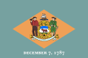
|
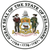
|
| Flag
|
Seal
|
Nickname(s): The First State; The Small Wonder;
Blue Hen State; The Diamond State
|
| Motto(s): Liberty and Independence
|
|
|
|
| Capital |
Dover
|
| Largest city |
Wilmington
|
| Area |
Ranked 49th
|
| - Total |
2,490 sq mi
(6,452 km²)
|
| - Width |
30 miles (48 km)
|
| - Length |
96 miles (154 km)
|
| - % water |
21.5
|
| - Latitude |
38° 27′ N to 39° 50′ N
|
| - Longitude |
75° 3′ W to 75° 47′ W
|
| Population |
Ranked 45th in the U.S.
|
| - Total |
907,135 (2011 est)[1]
|
| - Density |
464/sq mi (179/km2)
Ranked 6th in the U.S.
|
| - Median income |
$50,152 (12th)
|
| Elevation |
|
| - Highest point
|
Near the
Ebright Azimuth[2][3]
447 ft (136.2 m)
|
| - Mean |
60 ft (20 m)
|
| - Lowest point |
Atlantic Ocean[2]
0 ft (0 m)
|
| Admission to Union
|
December 7, 1787 (1st)
|
| Governor |
Jack A. Markell (D)
|
| Lieutenant Governor |
Matthew P. Denn (D)
|
| U.S. Senators |
Thomas R. Carper (D)
Chris Coons (D)
|
| Time zone
|
Eastern: UTC-5/-4
|
| Abbreviations
|
DE Del. US-DE
|
| Web site
|
delaware.gov
|
Delaware is a state located on the Atlantic Coast in the Mid-Atlantic region of the United States. While the U.S. Census Bureau designates Delaware as one of the South Atlantic States, most consider it to be a part of the Mid-Atlantic States and/or Northeastern United States.
The state is named after the Delaware Bay and River, which were named for Thomas West, 3rd Baron De La Warr (1577–1618). Delaware was the first state to ratify the U.S. Constitution and is also distinguished as being a slave state that remained in the Union during the American Civil War. Delaware was the only slave state not to assemble Confederate regiments or militia groups on its own.
Despite being the 45th most populous state, it is the seventh most densely populated state, with a population density of 320 more people per square mile than the national average, ranking ahead of states such as Florida, California, and Texas.
Geography
The state of Delaware is 96 miles long and ranges from 9 to 35 miles across, totaling 1,954 square miles and making it the second-smallest state in the United States, after Rhode Island.
Delaware is bounded to the north by Pennsylvania, to the east by the Delaware River, Delaware Bay, New Jersey and the Atlantic Ocean and to the west and south by Maryland. Small portions of Delaware are also situated on the far, or eastern, side of the Delaware River Estuary, and these small parcels share land boundaries with New Jersey.
The state of Delaware, together with the Eastern Shore counties of Maryland and two counties of Virginia, form the Delmarva Peninsula, a geographical unit stretching far down the Mid-Atlantic Coast.
The Chesapeake and Delaware Canal extends across the northern part of the state to link Delaware Bay and Chesapeake Bay. The canal forms part of the Intracoastal Waterway.
The definition of the northern boundary of the state is highly unusual. Most of the boundary between Delaware and Pennsylvania is defined by an arc extending 12 miles (19 km) from the cupola of the courthouse in New Castle, and is referred to as the Twelve-Mile Circle.
Wilmington is the state's largest city and its economic hub. It is located within commuting distance of both Philadelphia and Baltimore. Despite Wilmington's size, all regions of Delaware have enjoyed phenomenal growth, with Dover and the beach resorts expanding immensely. Dover, in the center of the state, is the capital.
Topography
Delaware is on a level plain; the highest elevation does not even rise 450 feet above sea level. The northern part is associated with the Appalachian Piedmont and is full of hills with rolling surfaces. South of Newark and Wilmington, the state follows the Atlantic Coastal Plain with flat, sandy, and, in some parts, swampy ground. A ridge about 75 to 80 feet in altitude extends along the western boundary of the state and is the drainage divide between the two major water bodies of the Delaware River and several streams falling into Chesapeake Bay in the west.
Climate
Since almost all of Delaware is a part of the Atlantic Coastal Plain, the climate is moderated by the effects of the ocean. The state is somewhat of a transitional zone between a humid subtropical climate and a continental climate. Despite its small size (roughly 100 miles from its northernmost to southernmost points), there is significant variation in mean temperature and amount of snowfall. The southern portion of the state has a somewhat milder climate and a longer growing season than the northern portion. Furthermore, the transitional climate of Delaware supports a surprising variety of vegetation. At Trap Pond State Park in Sussex County, bald cypress grow; this is thought to be one of the northernmost stands of these trees. The vegetation in New Castle County, on the other hand, is more typical of that of the northeastern United States. All parts of Delaware have relatively hot, humid summers.
History
Native Americans

Lapowinsa, Chief of the Lenape, one of the
Native American tribes that lived in the area that became Delaware.
Before Delaware was settled by European colonists, the area was home to the Eastern Algonquian tribes known as the Unami Lenape or Delaware throughout the Delaware valley, and the Nanticoke along the rivers leading into the Chesapeake Bay. The Unami Lenape in the Delaware Valley were closely related to Munsee Lenape tribes along the Hudson River. They had a settled hunting and agricultural society, and they rapidly became middlemen in an increasingly frantic fur trade with their ancient enemy, the Minqua or Susquehannock. With the loss of their lands on the Delaware River and the destruction of the Minqua by the Iroquois of the Five Nations in the 1670s, the remnants of the Lenape had left the region and moved over the Alleghany Mountains by the mid-eighteenth century. A band of the Nanticoke tribe of Indians still remains in Sussex County.
Colonial Delaware
The Dutch were the first Europeans to settle in present-day Delaware by establishing a trading post at Zwaanendael, near the site of Lewes in 1631. Within a year all the settlers were killed in a dispute with Native Americans. In 1638, a Swedish trading post and colony was established at Fort Christina (now in Wilmington) by the Dutchman Peter Minuit at the head of a group of Swedes, Finns and Dutch. Thirteen years later the Dutch, reinvigorated by the leadership of Peter Stuyvesant, established a new fort in 1651, at present-day New Castle, and in 1655, they took over the entire Swedish colony, incorporating it into the Dutch New Netherland.
Only nine years later, in 1664, the Dutch were themselves forcibly removed by a British expedition under the direction of James, the Duke of York. Fighting off a prior claim by Cæcilius Calvert, 2nd Baron Baltimore, Proprietor of Maryland, the Duke passed his somewhat dubious ownership on to William Penn in 1682. Penn strongly desired access to the sea for his Pennsylvania province and leased what then came to be known as the "Lower Counties on the Delaware" from the Duke.
Penn established representative government and briefly combined his two possessions under one General Assembly in 1682. However, by 1704 the Province of Pennsylvania had grown so large that their representatives wanted to make decisions without the assent of the Lower Counties, and the two groups of representatives began meeting on their own, one at Philadelphia, and the other at New Castle. Penn and his heirs remained proprietors of both and always appointed the same person as governor for their Province of Pennsylvania and their territory of the Lower Counties. (The fact that Delaware and Pennsylvania shared the same governor was not unique. During much of the colonial period New York and New Jersey shared the same governor, as did Massachusetts and New Hampshire.)
American Revolution
Like the other middle colonies, the Lower Counties on the Delaware initially showed little enthusiasm for a break with Britain. The citizenry had a good relationship with the Proprietary government and generally were allowed more independence of action in their Colonial Assembly than in other colonies. Nevertheless, there was strong objection to the seemingly arbitrary measures of Parliament, and it was well understood that the territory's very existence as a separate entity depended upon its keeping step with its powerful neighbors, especially Pennsylvania.

Caesar Rodney successfully led a much divided Delaware population through the revolutionary era.
So it was that New Castle lawyer Thomas McKean denounced the Stamp Act in the strongest terms, and John Dickinson became the "Penman of the Revolution." Anticipating the Declaration of Independence, Patriot leaders McKean and Caesar Rodney convinced the Colonial Assembly to declare itself separated from British and Pennsylvania rule on June 15, 1776, but the person best representing Delaware's majority, George Read, could not bring himself to vote for a Declaration of Independence. Only the dramatic overnight ride of Rodney gave the delegation the votes needed to cast Delaware's vote for Independence. Once the Declaration was adopted, however, Read signed the document.
Delaware provided one of the premier regiments in the Continental Army, known as the "Delaware Blues" and nicknamed the "Blue Hen Chickens." In August 1777, General Sir William Howe led a British army through Delaware on his way to a victory at the Battle of Brandywine and captured of the city of Philadelphia. The only real engagement on Delaware soil was fought on September 3, 1777, at Cooch's Bridge in New Castle County. It is believed to be the first time that the Stars and Stripes was flown in battle.
Following the Battle of Brandywine, Wilmington was occupied by the British. The British remained in control of the Delaware River for much of the rest of the war, disrupting commerce and providing encouragement to an active Loyalist portion of the population, particularly in Sussex County. Only the repeated military activities of Caesar Rodney were able to control them.
Following the American Revolution, statesmen from Delaware were among the leading proponents of a strong central United States government with equal representation for each state. Once the Connecticut Compromise was reached—creating a U.S. Senate and U.S. House of Representatives—the leaders in Delaware were able to easily secure ratification of the U.S. Constitution on December 7, 1787, making Delaware the first state to do so.
Industrialization
In the 1790s, the mills along Brandywine Creek near Wilmington were the new country’s leading source of flour. In 1795, Delaware’s first cotton mill was established near Wilmington, and in 1802, Eleuthère Irénée du Pont de Nemours, a French immigrant, established a gunpowder mill. His firm, E.I. du Pont de Nemours and Company, supplied nearly all the military explosives used by the United States in its wars and evolved into one of the world’s largest chemical manufacturing firms, providing about 8,000 jobs.
New transportation links in the early nineteenth century encouraged trade. The completion in 1829 of the Chesapeake and Delaware Canal, between Delaware Bay and Chesapeake Bay, stimulated shipping. Delaware’s first steam-driven railroad went into operation in 1832.
Slavery and race

Peter Spencer, born a slave in
Maryland in 1782, founded the first independent black Christian Church in Delaware in 1813, the A.U.M.P. Church.
Many colonial settlers came from Maryland and Virginia, which had been experiencing a population boom. The economies of these colonies were largely based on tobacco and were increasingly dependent on slave labor. At the end of the colonial period, slavery in Delaware began a precipitous decline. Shifts in the agriculture economy, the efforts of local Methodists and Quakers, and greater governmental regulation were all factors. Attempts to abolish slavery failed by narrow margins. By the 1860 census there were only about 1,800 slaves in a state of 90,000 people, including nearly 20,000 free African-Americans. When he freed his slaves in 1777, John Dickinson was Delaware's largest slave owner with 37 slaves. By 1860, the largest owner had 16 slaves.
The oldest black church in the country was chartered in Delaware by former slave Peter Spencer in 1813, as the "Union Church of Africans," which is now the A.U.M.P. Church.
During the American Civil War, Delaware was a slave state that remained in the Union (Delaware voted not to secede on January 3, 1861). Delaware had been the first state to embrace the Union by ratifying the Constitution and would be the last to leave it, according to Delaware's governor at the time. While most Delaware citizens who fought in the war served in the regiments of the state, some served in companies on the Confederate side in Maryland and Virginia regiments. Delaware is notable for being the only slave state not to assemble Confederate regiments or militia groups on its own.
Nevertheless, race relations have remained difficult. The state’s public schools were segregated by race until the Supreme Court of the United States struck down racial segregation in its 1954 decision, Brown v. Board of Education. But de facto segregation—racial imbalance of schools caused by residence patterns—continued to be a problem into the 1970s and beyond. In 1978, a federal court mandated the busing of students to achieve racial balance, which was ended in 1995, when it was found that the goals of integration had been achieved. Segregated housing was also common throughout the state until the federal government banned it in 1968.
A modern economy
In the 1970s, the state legislature drew out-of-state banks' credit card operations to locate in Delaware by relaxing regulations on interest rates they charge their customers. Delaware has also become the corporate home of hundreds of major and minor corporations that take advantage of the state's unrestrictive incorporation law. In 1988, when many American businesses faced hostile corporate takeovers, the legislature enacted a law that makes it difficult to take over a Delaware corporation.
Demographics
Population estimates by the Census Bureau for 2005 place the population of Delaware at 843,524.
The five largest ancestries in Delaware are: African-American (19.2 percent), Irish (16.6 percent), German (14.3 percent), English (12.1 percent), Italian (9.3 percent). Delaware has the highest proportion of African-American residents of any state north of Maryland, and had the largest population of free blacks (17 percent) prior to the Civil War.
As of 2000, 90.5 percent of Delaware residents age 5 and older speak only English at home; 4.7 percent speak Spanish. French is the third most spoken language at 0.7 percent, followed by Chinese at 0.5 percent and German at 0.5 percent. In 2006, legislation was proposed in Delaware that would designate English as the official language, though opponents deemed it unnecessary.
The religious affiliations of the people of Delaware are[4]:
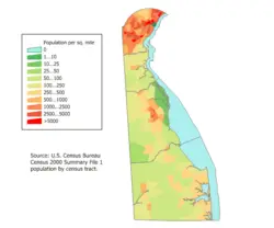
Delaware Population Density Map
The A.U.M.P. Church, the oldest African-American denomination in the nation, was founded in Wilmington and still has a very substantial presence in the state.
Economy

"Picking Peaches in Delaware" from an 1878 issue of Harper's Weekly
Delaware's agricultural output consists of poultry, nursery stock, soybeans, dairy products and corn. Its industrial outputs include chemical products, processed foods, paper products, and rubber and plastic products. Delaware's economy generally outperforms the national economy of the United States.
The gross state product of Delaware in 2003 was $49 billion. The per capita personal income was $34,199, ranking 9th in the nation. In 2005, the average weekly wage was $937, ranking 7th in the nation. [5]
The state's largest employers are:
- Government (State of Delaware, New Castle County)
- Education (University of Delaware)
- Chemical and pharmaceutical companies
- (E.I. du Pont de Nemours & Co.—DuPont is the second largest private employer in Delaware, providing more than 8,800 jobs.[6] Also, Syngenta, AstraZeneca, and Hercules, Inc.)
- Banking (Bank of America, Wilmington Trust, First USA / Bank One / JPMorgan Chase, AIG, Citigroup, Deutsche Bank)
- Automotive manufacturing (General Motors, DaimlerChrysler)
- Farming, specifically chicken farming in Sussex County (Perdue Farms, Mountaire Farms)
Dover Air Force Base, located in the capital city of Dover, is one of the largest Air Force bases in the country and is a major employer in Delaware. In addition to its other responsibilities, the base serves as the entry point and mortuary for American military persons (and some U.S. government civilians) who die overseas.
The state does not assess sales tax on consumers. The state does, however, impose a tax on the gross receipts of most businesses. Delaware does not assess a state-level tax on real or personal property. Real estate is subject to county property taxes, school district property taxes, vocational school district taxes, and, if located within an incorporated area, municipal property taxes.
Law and government

State Capitol building in Dover.
The city of Dover is the capital and second largest city in Delaware. It is also the county seat of Kent County, and the principal city of the Dover, Delaware Metropolitan Statistical Area which encompasses all of Kent County.
It was founded as the court town for newly established Kent County in 1683 by William Penn, the Proprietor of the territory generally known as the "Lower Counties on the Delaware." Later, in 1717, the city was officially laid out by a special commission of the Delaware General Assembly. The capital of the state of Delaware was moved to Dover from New Castle in 1777 due to its central location and relative safety from British raiders on the Delaware River.
Dover is located on the St. Jones River in the Delaware River coastal plain and as of July 2006, had an estimated population of 34,735.[7]
Delaware's fourth and current constitution, adopted in 1897, provides for executive, judicial and legislative branches. The General Assembly consists of a House of Representatives with 41 members and a Senate with 21 members. Representatives are elected to two-year terms, while senators are elected to four-year terms. The executive branch is headed by the governor of Delaware.
Delaware has three counties: Kent County, New Castle County, and Sussex County. Each county elects its own legislative body.
The Democratic Party holds a plurality of registrations in Delaware. Until the 2000 presidential election, the state tended to be a bellwether state, sending its three electoral votes to the winning candidate for over 50 years in a row. Bucking that trend, however, in 2000 and again in 2004 Delaware voted for the Democratic candidate.
Historically, the Republican Party had an immense influence on Delaware politics, due in large part to the wealthy du Pont family. As the DuPonts' political influence has declined, so has that of the Delaware Republican Party. The Democrats have won the past four gubernatorial elections and currently hold seven of the nine statewide elected offices, while the Republicans hold the remaining two. The Democratic Party gains most of its votes from heavily developed New Castle County, whereas the less-populated Kent and Sussex Counties vote Republican.
Notes
- ↑ Error on call to template:cite web: Parameters url and title must be specified (CSV). 2011 Population Estimates. United States Census Bureau, Population Division (December 2011).
- ↑ 2.0 2.1 Elevations and Distances in the United States. United States Geological Survey (2001). Retrieved October 21, 2011.
- ↑ Elevation adjusted to North American Vertical Datum of 1988.
- ↑ The Graduate Center, City University of New York, American Religious Identification Survey. Retrieved September 21, 2008.
- ↑ Delaware Online, Delaware workers earn 7th-highest salary in U.S. Note: value of $937 per week was for the 4th quarter of 2005. Retrieved December 13, 2007.
- ↑ Delaware Online, DuPont cuts jobs to grow seeds. Retrieved December 13, 2007.
- ↑ U.S. Census Bureau, Population Division, Population Estimates for All Places: 2000 to 2006.
References
ISBN links support NWE through referral fees
- Heinegg, Paul. Free African Americans of Maryland and Delaware. Retrieved June 8, 2020.
- Kolchin, Peter. American Slavery, 1619-1877. New York: Hill and Wang, 1993. ISBN 978-0809025688
- Riordan, Liam. Many Identities, One Nation: The Revolution and its Legacy in the Mid-Atlantic. Philadelphia: University of Pennsylvania Press, 2007. ISBN 0812240014
- Schama, Simon. Rough Crossings: Britain, the Slaves, and the American Revolution. New York: Ecco, 2006. ISBN 978-0060539160
External links
All links retrieved January 28, 2024.
| US South (as defined by the United States Census Bureau) |
|---|
| |
|
Coordinates: 39° N 75.5° W
Credits
New World Encyclopedia writers and editors rewrote and completed the Wikipedia article
in accordance with New World Encyclopedia standards. This article abides by terms of the Creative Commons CC-by-sa 3.0 License (CC-by-sa), which may be used and disseminated with proper attribution. Credit is due under the terms of this license that can reference both the New World Encyclopedia contributors and the selfless volunteer contributors of the Wikimedia Foundation. To cite this article click here for a list of acceptable citing formats.The history of earlier contributions by wikipedians is accessible to researchers here:
The history of this article since it was imported to New World Encyclopedia:
Note: Some restrictions may apply to use of individual images which are separately licensed.


