La Paz
| Nuestra Señora de La Paz La Paz (Spanish) Chuquiago Marka or Chuqiyapu (Aymara) La Paz (English) |
|||
 with the Illimani mountain in the background. |
|||
|
|||
| Motto: "Los discordes en concordia, en paz y amor se juntaron y pueblo de paz fundaron para perpetua memoria" | |||
 Nuestra Señora de La Paz |
|||
| Coordinates: 16°30′S 68°09′W | |||
|---|---|---|---|
| Country | |||
| Departament | La Paz | ||
| Province | Pedro Domingo Murillo | ||
| Founded | October 20, 1548 by Alonso de Mendoza | ||
| Independence | July 16, 1809 | ||
| Government | |||
| - Mayor | Luis Antonio Revilla Herrero | ||
| Area | |||
| - City | 472 km² (182.2 sq mi) | ||
| - Urban | 3,240 km² (1,251 sq mi) | ||
| Elevation | 3,640 m (11,942 ft) | ||
| Population (2008) | |||
| - City | 877,363 | ||
| - Density | 1,861.2/km² (4,820.6/sq mi) | ||
| - Metro | 2,364,235 | ||
| Time zone | BOT (UTC−4) | ||
| Area code(s) | 2 | ||
| HDI (2010) | 0.672 – high | ||
| Website: www.lapaz.bo | |||


La Paz, also known by the full name Nuestra Señora de La Paz (“Our Lady of Peace”), is the administrative capital of Bolivia. La Paz, which lies between 10,650 and 13,250 feet (3,250 and 4,100 meters) above sea level, is the highest capital city in the world, and is home to the world's highest golf course, football stadium, velodrome, and airplane landing strip. Located 42 miles (68 km) southeast of Lake Titicaca, the city lies in a deep, broad canyon formed by the La Paz River.
The Spanish Viceroy of Peru had La Paz founded in 1548, in an area where a major native aboriginal civilization, the Tiwanaku culture, had existed for almost 1500 years. La Paz grew as the Spanish Empire extracted silver from the area.
Since the Bolivian revolution in 1952, La Paz has been the center of political turmoil, in which the government changed hands repeatedly, after revolts by rival military officers, and as a result of coups, counter-coups, and caretaker governments.
La Paz is renowned for its unique markets, unusual topography, and rich traditional culture.
Geography
The full name of the city, Nuestra Señora de La Paz, means "Our Lady of Peace," and commemorates the restoration of peace following the end of the civil wars in Peru and after an insurrection in 1544. The city is also known as Chuquiago Marka, or Chuqiyapu from Aymara. "Chuqi" means "gold," and "yapu" means "farm."
Located in west-central Bolivia, 42 miles (68km) southeast of Lake Titicaca, La Paz, which is at an elevation of between 10,650 and 13,250 feet (3250 and 4100 meters) above sea level, is the world’s highest national capital.
La Paz is near the famous mountains including the Illimani (guardian of La Paz), Huayna Potosi, Mururata, and Illampu. On the western side of the Altiplano divide, about an hour to the west of the La Paz, is the site of the tallest mountain in Bolivia and ninth tallest mountain in the Andes, the Sajama Volcano.
La Paz was built in a canyon created by the Choqueyapu River (now mostly built over), which runs northwest to southeast. The city's main thoroughfare, which roughly follows the river, changes names over its length, but the central tree-lined section running through the downtown core is called the Prado.
The weather in La Paz is usually bright and sunny all year. The high altitude means temperatures are consistently cool throughout the year, though the diurnal temperature variation is typically large. The average maximum daytime temperature in January is 77°F (25°C), dropping to an average maximum of around 71.6°F (22°C) in July. The city has a relatively dry climate, with rainfall occurring mainly (in showers most afternoons) in the slightly warmer months of November to March. Average annual precipitation is 22.6 inches (575 mm).
The industrial pollution of water supplies used for drinking and irrigation is an environmental issue.
While many middle-class residents live in high-rise condos near the center of the city, the houses of the truly affluent are located in the lower neighborhoods southwest of the Prado. The surrounding hills are plastered with makeshift brick houses of the less affluent.
The satellite city of El Alto, in which the airport is located, is spread over a broad area to the west of the canyon, on the Altiplano.
History
.jpg)
While there is evidence that the Andean region was inhabited 10,000 years ago, from about 100 C.E., a major Indian civilization called the Tiwanaku culture developed at the southern end of Lake Titicaca, built gigantic monuments and carved statues out of stone. However, their civilization declined rapidly during the thirteenth century.
By the late fourteenth century, a warlike tribe called the Aymara controlled much of western Bolivia. The Inca Indians of Peru defeated the Aymara during the fifteenth century and made Bolivia part of their huge empire until the Spanish conquest in 1538. The Incas forced their religion, customs, and language, Quechua, on their defeated rivals. But the Aymara resisted full assimilation, and maintained their separate language and many customs.
On behalf of the Spanish king, Pedro de la Gasca (1485-1567), the second viceroy of Peru, commanded Captain Alonso de Mendoza to found a new city commemorating the end of the civil wars in Peru. The city of La Paz was founded on October 20, 1548, as a commercial city, lying on the main gold and silver route to the coast. The Spaniards, who came for the gold found in the Choqueapu River that runs through La Paz, enslaved the former owners, the Aymara people. The primarily male Spanish population soon mixed with the indigenous people, creating a largely mestizo, or mixed, population.
In 1549, Juan Gutierrez Paniagua was commanded to design an urban plan for La Paz that would designate sites for public areas, plazas, official buildings, and a cathedral. La Plaza de los Españoles, which is known today as the Plaza Murillo, was chosen as the location for government buildings as well as the Metropolitan Cathedral.
During most of the Spanish colonial period, Bolivia was a territory called "Upper Peru" or "Charcas" and was under the authority of the viceroy of Peru. Local government came from the Audiencia de Charcas located in Chuquisaca (modern Sucre). Bolivian silver mines produced much of the Spanish empire's wealth, so Spain controlled La Paz with a firm grip.
In 1781, for six months, a group of Aymara people under the leadership of Tupac Katari (1750–1781), besieged La Paz, destroyed churches, and destroyed government property. The siege was broken by colonial troops from Lima and Buenos Aires, and Tupac Katari was executed.
By 1800, La Paz had become the largest city of Upper Peru, acting as the center of population growth and agricultural production. Many large estate land holders, known as haciendados, lived in La Paz for most of the year while they maintained a small community of indigenous people to live and work on their haciendas (landed estates). Fine examples of old Spanish colonial architecture in houses close to the central plazas remain from this period.
As Spanish royal authority weakened during the Napoleonic wars from 1803 to 1815, resentment towards colonial rule grew. Independence was proclaimed in 1809, but 16 years of struggle followed before the establishment of the republic, on August 6, 1825. The republic was named after the Venezuelan general who led South American independence, Simón Bolívar (1783-1830).
In 1825, after a decisive victory of republicans at Ayacucho over the Spanish army, the city's full name was changed to La Paz de Ayacucho or The Peace of Ayacucho.
Simon Bolivar was the first president of the republic, and the country was divided into five departments: La Paz, Cochabamba, Potosi, Charkas, and Santa Cruz de la Sierra.


By 1840, Bolivia exported more than it imported, allowing the government to invest in infrastructure. La Paz grew as the financial, commercial, and political capital, but was isolated by poor roads and the lack of rail lines leading over the harsh Altiplano to ports in Peru and Chile.
During the War of the Pacific (1879–1883), Bolivia lost its seacoast and the adjoining rich nitrate fields to Chile.
In 1898, La Paz was made the de facto seat of the national government, with Sucre remaining the historical and judiciary capital. By then, the Bolivian economy moved away from the largely exhausted silver mines of Potosí to exploitation of tin near Oruro.
Construction began, in 1900, on the international railroad network linking La Paz to the Pacific and Atlantic coasts, thus solidifying the role of La Paz as the main city of Bolivia.
The first oil company came to Bolivia in 1921, when Bolivia was found to have great reserves of oil, in addition to it's precious minerals.
A succession of governments, espousing laissez-faire capitalist policies, which seek to allow events to take their own course, was controlled by an economic and social elite that did little to create an economy based on genuine production of goods and services. Rather, they acquired wealth by controlling and selling natural resources. The living conditions of the indigenous people, who constituted most of the population, remained deplorable. Forced to work in primitive conditions in the mines almost like slaves, they were denied access to education, economic opportunity, or political participation.
In 1932, Bolivia and Paraguay fought over ownership of the Gran Chaco, a large lowland plain bordering the two countries thought to be rich in oil. Bolivia was defeated in 1935 and eventually gave up most of the disputed land, which was later found to lack oil.
The Chaco War led to growing dissatisfaction with the ruling elite, resulting in the emergence of the Nationalist Revolutionary Movement, a broadly based left-wing party.
The party initiated a brief but bloody civil war in October 1949, but was defeated and exiled. The Nationalist Revolutionary Movement won the 1951 elections, but the results were called fraudulent by the opposition, and its right to the presidency was denied. On April 9, 1952, the Nationalist Revolutionary Movement led a revolt and set into motion the Bolivian National Revolution.
Under President Víctor Paz Estenssoro and later, Hernan Siles, the Nationalist Revolutionary Movement introduced universal adult suffrage, carried out a sweeping land reform, promoted rural education, and nationalized the country's largest tin mines. This in turn sparked a great growth spurt in La Paz, as many working-class and poor migrated to urban areas.
In the mid-1960s, Che Guevara (1928–1967), an Argentine-born physician, Marxist, politician, and a colleague of Cuba's Fidel Castro, tried to mount another revolution in Bolivia, but was betrayed by the Bolivian peasantry he had come to liberate to Bolivian troops, who killed him on October 9, 1967.
From 1964 through to the 1970s, control of the Bolivian government changed hands repeatedly, mostly after revolts by rival military officers. Alarmed by public disorder, the military, the Nationalist Revolutionary Movement, and others installed Colonel (later General) Hugo Banzer Suárez (1926–2002) as president in 1971. Banzer ruled with Nationalist Revolutionary Movement support from 1971 to 1978. The economy expanded during most of Banzer's presidency, but human rights violations and eventual fiscal crises undercut his support.
Successive elections in the 1970s led to coups, counter-coups, and caretaker governments. In the 1985, 1989, 1993, 1997, and 2002 presidential elections, no candidate won a majority of the popular vote.
Hugo Banzer was chosen to serve as president again in 1997. Banzer used special police units to eradicate Bolivia's illegal coca, producing a dramatic four-year decline in Bolivia's illegal coca crop. Those left unemployed by coca eradication streamed into the cities, especially El Alto, the slum neighbor of La Paz, exacerbating social tensions and giving rise to a new indigenous political movement.
In 2002, Gonzalo Sánchez de Lozada (born 1930) again became president. In October 2003, Sánchez resigned after two months of rioting and strikes over a gas-exporting project that protesters believed would benefit foreign companies more than Bolivians.
On December 18, 2005, Evo Morales (born 1959), the indigenous leader of the Movement Towards Socialism party, was elected to the presidency by 54 percent of the voters, an unprecedented absolute majority in Bolivian elections.
Morales is also president of Bolivia's cocalero movement—a loose federation of coca growers' unions, made up of campesinos who are resisting the efforts of the United States government to eradicate coca.
Government
Bolivia is a republic. The president, who is both chief of state and head of government, is elected by popular vote for a single five-year term. The bicameral National Congress, or Congreso Nacional, consists of Chamber of Senators of 27 members elected by proportional representation from party lists to serve five-year terms, and a Chamber of Deputies of 130 members, 70 of whom are directly elected from their districts and 60 are elected by proportional representation from party lists, all to serve five-year terms.
Bolivia is divided into nine departments, which are further divided into 100 provinces. The provinces are each divided into municipalities and cantons, which handle local affairs. In addition to being the nation's administrative capital, the city of La Paz is also capital of the La Paz department.
Economy

Bolivia is one of the poorest and least developed countries in Latin America. In 2005, the government passed a controversial hydrocarbons law that imposed higher royalties and required foreign firms to surrender all production to the state energy company, which was made the sole exporter of natural gas. Per capita GDP was estimated at $4400 in 2007. During a long period of high inflation and economic struggle in the 1980s and early 1990s, a large informal economy developed. Almost every street in the downtown area of La Paz and surrounding neighborhoods has at least one vendor on it.
About two-thirds of Bolivia's manufacturing is located in and around La Paz. Food stuffs, tobacco products, clothing, various consumer goods, building materials, and agricultural tools are produced, mostly in small factories.
Railways and highways connect La Paz with Peruvian and Chilean seaports and with Argentina and Brazil. La Paz Bus Station, previously bus and train station, is the main gateway for intercity bus travel in La Paz, and connects the city with Santiago, Chile, and Lima, Peru. El Alto International Airport is located eight miles (14km) southwest of La Paz, above the city on the plateau.
Demographics
The city of La Paz had a population of 877,363 in 2008, and together with the neighboring cities of El Alto and Viacha, make the largest urban area of Bolivia, with a population of over 1.6 million inhabitants. Quechua made up 30 percent of Bolivia's population in 2001, mestizo (mixed white and Amerindian ancestry) 30 percent, Aymara 25 percent, and white 15 percent.
Spanish, spoken by 60.7 percent of Bolivia's population in 2001, was an official language of Bolivia, along with Quechua 21.2 percent, and Aymara 14.6 percent. Foreign languages were spoken by 2.4 percent, other 1.2 percent. Roman Catholics made up 95 percent of Bolivia's population, and Protestants (Evangelical Methodist) five percent.
The University of San Andrés, founded in 1830, and the Bolivian Catholic University, founded in 1966, are located in La Paz.
Society and culture


La Paz, which is Bolivia's cultural capital, is located near numerous ancient ruins, especially the Tiwanaku (Tiahuanacu) ruins, a World Heritage Site which is thousands of years older than Macchu Picchu in Peru. Tiwanaku is recognized as one of the most important precursors to the Inca Empire, flourishing as the ritual and administrative capital of a major state power for approximately 500 years. The ruins of the ancient city state are near the southeastern shore of Lake Titicaca, about 44 miles (72 km) west of La Paz.
Another day trip visit tourists usually include is the Lake Titicaca and the lakeside city of Copacabana (its Cathedral is visited by many Bolivians to see the Virgen de Copacabana figure, Deity of the Lake).
The city has hundreds of museums, the Palacio Quemado (executive building), the Congress, the Valley of the Moon, the Cine-Teatro Municipal (built in the nineteenth century), the Cementerio General (where many of Bolivia's presidents are buried), the house of Simon Bolivar, the Devil's Tooth (geological formation, hiking site), and many more. Other sites of interest include:
- The Cathedral of San Francisco, named after the founder Francisco de los Angeles Morales, whose remains are interred there. The Franciscans arrived in the Chuquiago valley before the founder of La Paz, Alonzo de Mendoza. Generous Cacique (chief) of Quirquincha gave them the land for construction of the monastery that remains the main attraction of La Paz.
- The San Francisco square, which is the busiest place of La Paz, with bus and taxi stops, souvenir street Sagarnaga, inexpensive snack-bars, and hundreds of little shops.
- The Metropolitan Cathedral, built in neoclassical style between 1835 and 1987, which is the location of the remains of the revolutionary leader Antonio José de Sucre (1795–1830).
- Calle Jaén, near the city center and Plaza Murrllo, is a charming colonial street where the buildings and cobblestoned street have been preserved, without traffic, is the location of 10 museums, including Museo Murillo, once owned by Pedro Domingo Murillo, a hero of the Bolivian republic, and the Museo de Litoral, which displays items from the War of the Pacific (1879-1884).
La Paz is the home field of some of the biggest football teams in Bolivia, including Club Bolivar, The Strongest, and La Paz F.C. All teams play most of their games in the city stadium, Estadio Hernando Siles, which hosts several other teams that play in the first and second divisions. La Paz also hosts the national soccer team and a plethora of international games.

Looking to the future
As Bolivia's cultural capital, La Paz has hundreds of museums, cathedrals, the charming Calle Jaén colonial street, and is close to the Tiwanaku World Heritage Site. But as Bolivia's administrative capital city, La Paz has gone through extended periods of administrative instability, including a series of nearly 200 coups and countercoups, deep-seated poverty, social unrest, and illegal drug production.
Since 2005, the government of Evo Morales, which sought to empower the nation's poor majority, has worsened racial and economic tensions between the Amerindian populations of the Andean west and the non-indigenous communities of the eastern lowlands. In addition, a controversial hydrocarbons law that imposed significantly higher royalties and required foreign firms to surrender all production to the state energy company is likely to impede Bolivia's ability to profit from newly discovered natural gas reserves.[1]
Gallery
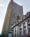
Bolivian Central Bank
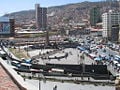
Center of La Paz
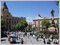
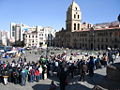
Plaza Murillo with Government and Legislative Palaces in the background
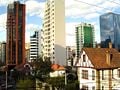
San Jorge, La Paz
Plaza San Francisco
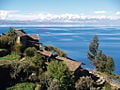
Titicaca Lake near La Paz with the Andes in the background
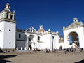
Copacabana Church


Notes
- ↑ CIA World Factbook,.
ReferencesISBN links support NWE through referral fees
- Gill, Lesley. 2000. Teetering on the Rim: Global Restructuring, Daily Life, and the Armed Retreat of the Bolivian State. New York: Columbia University Press. ISBN 9780231118057.
- Hudson, Rex A., and Dennis Michael Hanratty. 1991. Bolivia: A Country Study. Area handbook series. Washington, D.C.: Federal Research Division, Library of Congress. ISBN 9780160321276.
- Klein, Herbert S., and Herbert S. Klein. 2003. A Concise History of Bolivia. Cambridge Concise Histories. Cambridge, U.K.: Cambridge University Press. ISBN 9780521002943.
- Klein, Herbert S. 1982. Bolivia, the Evolution of a Multi-Ethnic Society. Latin American histories. New York: Oxford University Press. ISBN 9780195030129.
- World Factbook. 2009. Bolivia. Retrieved January 11, 2009.
External links
All links retrieved March 7, 2025.
-
- Mapping from Multimap or GlobalGuide or Google Maps
- Satellite image from WikiMapia
- Mapping from OpenStreetMap
Asunción, Paraguay · Bogotá, Colombia · Brasília, Brasil · Buenos Aires, Argentina · Caracas, Venezuela · Cayenne, French Guiana · Georgetown, Guyana · Grytviken, South Georgia and the South Sandwich Islands · La Paz, Bolivia · Lima, Peru · Montevideo, Uruguay · Paramaribo, Suriname · Quito, Ecuador · Santiago, Chile · Sucre, Bolivia · Stanley, Falkland Islands
Credits
New World Encyclopedia writers and editors rewrote and completed the Wikipedia article in accordance with New World Encyclopedia standards. This article abides by terms of the Creative Commons CC-by-sa 3.0 License (CC-by-sa), which may be used and disseminated with proper attribution. Credit is due under the terms of this license that can reference both the New World Encyclopedia contributors and the selfless volunteer contributors of the Wikimedia Foundation. To cite this article click here for a list of acceptable citing formats.The history of earlier contributions by wikipedians is accessible to researchers here:
The history of this article since it was imported to New World Encyclopedia:
Note: Some restrictions may apply to use of individual images which are separately licensed.