- "Anasazi" redirects here.

Ancient Pueblo People or Ancestral Pueblo peoples were an ancient Native American culture centered on the present-day Four Corners area of the United States, comprising southern Utah, northern Arizona, northwest New Mexico, and southern Colorado. They are one of four major prehistoric traditions from the American Southwest. This cultural group has often been referred to in archaeology as the Anasazi, although the term is not preferred by contemporary Pueblo peoples who are believed to be their descendants. The name pueblo derives from the Spanish word meaning "village," which the Spanish explorers called the communities of apartment-like dwellings they encountered in the early seventeenth century.
The origin and exact size and location of this group of people is not clear; nor is the reason for their sudden abandonment of their communities in the twelfth century. The modern Pueblo people generally claim them as their ancestors. However, this is still a matter of speculation, albeit supported by available archaeological evidence.
While many details of this culture's origin, lifestyle, and apparent collapse are unclear, the record of their history stands in the incredible architecture found in numerous sites in the Southwestern states. Thousands of ancient stone structures including cliff dwellings, kivas, "great houses," granaries, and much more remind us of the creative accomplishments of these people who lived so long ago.
Names
The name pueblo was given by the Spanish explorers who arrived in the Southwestern part of what is now the United States in the early sixteenth century to describe Native Americans communities that consisted of apartment-like structures. The word means "village" in the Spanish language. In general, modern Pueblo people claim the "Ancient Pueblo Peoples" as their ancestors.
This cultural group has often been referred to in archaeology as the Anasazi, although the term is not preferred by contemporary Pueblo peoples. Archaeologist Linda Cordell discussed the word's etymology and use:
The name "Anasazi" has come to mean "ancient people," although the word itself is Navajo, meaning "enemy ancestors." [The Navajo word is anaasází (anaa- "enemy," sází "ancestor").] The term was first applied to ruins of the Mesa Verde by Richard Wetherill, a rancher and trader who, in 1888–1889, was the first Anglo-American to explore the sites in that area. Wetherill knew and worked with Navajos and understood what the word meant. The name was further sanctioned in archaeology when it was adopted by Alfred V. Kidder, the acknowledged dean of Southwestern Archaeology. Kidder felt that it was less cumbersome than a more technical term he might have used. Subsequently some archaeologists who would try to change the term have worried that because the Pueblos speak different languages, there are different words for "ancestor," and using one might be offensive to people speaking other languages.[1]
David Roberts, explained his reason for using the term "Anasazi" over a term using "Puebloan," noting that the latter term "derives from the language of an oppressor who treated the indigenes of the Southwest far more brutally than the Navajo ever did."[2]
Some modern Pueblo peoples object to the use of the term Anasazi, although there is still controversy among them on a native alternative. The Hopi use the term Hisatsinom meaning the "ancient people"; another alternative is the Tewa language Se'da, meaning the "ancient ones."[3]
History
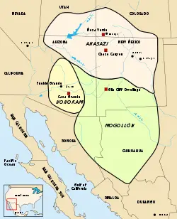
The Ancient Pueblo Peoples (Anasazi) were one of four major prehistoric archaeological traditions recognized in the American Southwest. The others are the Mogollon, Hohokam, and Patayan. Archaeologists use these cultural units to define material culture similarities and differences identified in prehistoric socio-cultural units. Since the names and divisions are classification devices based on theoretical perspectives, analytical methods, and data available at the time of analysis and publication they are subject to change. Therefore, it should not be assumed that these archaeological divisions or culture units necessarily correspond to a particular language group or to a socio-political entity such as a tribe.
These prehistoric groups were not separated by clear-cut boundaries. Prehistoric people traded, worshiped, collaborated, and fought with other nearby groups. In the Southwest, mountain ranges, rivers and, most obviously, the Grand Canyon were significant barriers for human communities, likely reducing the frequency of contact with other groups.
The Ancient Pueblo Peoples occupied the area known as the "Four Corners," a region consisting of the southwestern corner of Colorado, northwestern corner of New Mexico, northeastern corner of Arizona, and southeastern corner of Utah. Their homeland centers on the Colorado Plateau, but extends from central New Mexico on the east to southern Nevada on the west. Areas of southern Nevada, Utah and Colorado form a loose northern boundary, while the southern edge is defined by the Colorado and Little Colorado rivers in Arizona and the Rio Puerco and Rio Grande in New Mexico. However, structures and other evidence of Ancient Pueblo culture has been found extending east onto the American Great Plains, in areas near the Cimarron and Pecos rivers and in the Galisteo Basin.
Origins
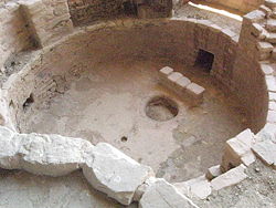
Modern Pueblo oral traditions hold that the Ancient Pueblo People originated to the north of their current settlements, from Shibapu (sipapu a Hopi word), where they emerged from the underworld.
According to Hopi mythology, the ancient ancestors first emerged through a hollow reed (or bamboo) that grew into the sky, and it emerged in the Fourth World at the sipapu. The people then climbed up the reed into this world where they were guided through several migrations until they reached their homeland.
Kivas used by the Ancient Pueblo Peoples and modern-day Puebloans have a small hole or indentation in the floor, symbolizing the sipapu.
Pecos Classification
The Pecos Classification is a division of all known Ancient Pueblo Peoples cultures into chronological phases, based on changes in architecture, art, pottery, and cultural remains. The original classification dates back to a 1927 archæological conference held in Pecos, New Mexico organized by American archaeologist Alfred V. Kidder. This original Pecos Classification contained eight stages of Southwestern prehistory but did not specify dates.
- Basketmaker I, or Early Basketmaker
- Basketmaker II, or Basketmaker
- Basketmaker III, or Post-Basketmaker
- Pueblo I, or Proto-Pueblo
- Pueblo II
- Pueblo III, or Great Pueblo
- Pueblo IV, or Proto-Historic
- Pueblo V, or Historic
Although the original has been significantly debated and sometimes modified over the years, the split into Basketmaker and Pueblo eras still serves as a basis for discussing the culture of the Ancient Puebloans. The following phases are generally accepted:
- Archaic Era - 8th millennium B.C.E. to 12th century B.C.E.
(The original classification postulated a Basketmaker I Era which was subsequently discredited due to lack of physical evidence, and rolled into the Archaic Era).
The pre-Anasazi culture that moved into the modern-day Southwestern United States after the big game hunters departed is called Archaic. Little evidence for extensive habitation before 8000 B.C.E. exists. From evidence near Navajo Mountain, they were nomadic people, hunter-gatherers traveling in small bands. They gathered wild foods when in season, and hunted with stone-tipped spears, atlatls, and darts. Game included rabbits, deer, antelope, and bighorn sheep. A trend toward a sedentary lifestyle, with small scale cultivation, began around 1000 B.C.E.
- Early Basketmaker II Era - 1200 B.C.E. to 50 C.E.
Early Anasazi camped in the open or lived in caves seasonally. During this period, they began to cultivate gardens of maize (flint corn in particular) and squash, but no beans. They used manos and metates to grind corn, made baskets, but had no pottery.
- Late Basketmaker II Era - 50 to 500
Primitive storage bins, cists, and shallow pithouses were constructed. At this stage, evidence suggests that the beginning of a religious and decision-making structure had already developed. Shamanistic cults existed and petroglyphs and other rock art seem to indicate a ceremonial structure as well.
- Basketmaker III Era - 500 to 750
Deep pit-houses were developed, along with some above-ground rooms. The bow and arrow replaced the atlatl and spear. Cultivation of beans, available due to trade from central America, and edible due to cooking in pottery vessels, developed. Wild amaranth and pinyon pine were also staples. People of this era may have domesticated turkeys. Prototype Kivas were large, round, and subterranean.
- Pueblo I Era - 750 to 900
Increasing populations, growing village size, social integration, and more complicated and complex agricultural systems typified this era. Year round occupation in pueblos begans; reservoirs and canals were used. Large villages and great kivas appeared, though pit-houses still remained in use. Above-ground construction is of jacal or crude masonry. Plain gray bisque pottery predominated, though some red bisque and pottery decorated in black and white appeared.
- Pueblo II Era - 900 to 1150
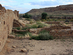
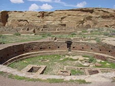
This was the "Golden Age" of the Ancient Pueblo Peoples. By 1050, Chaco Canyon (in present-day New Mexico) was a major regional center of 1,500–5,000 people. It was surrounded by standardized planned towns, or great houses, built from the wood of over 200,000 trees. Roads 30 feet (9.1 m) wide, flanked by berms, radiate from Chaco in various directions. Small blocks of above-ground masonry rooms and a kiva made up a typical pueblo. Great kivas grew to 50–70 feet (15–21 m) in diameter. Pottery consisted of corrugated gray bisque and decorated black-on-white in addition to some decorated red and orange vessels. Shells and turquoise were imported. More intense agriculture was characteristic, with terracing and irrigation common. During the twelfth century, populations began to grow after a decline at the end of the Pueblo II era.
- Pueblo III Era - 1150 to 1300
Settlements consist of large pueblos, cliff dwellings, towers, and turkey pens. Most villages in the Four Corners area were abandoned by 1300. The distinction between Hohokam and Ancient Pueblo became blurred.
- Pueblo IV Era - 1300 to 1600
Typically, large pueblos are centered around a plaza. Socially, a period of more conflict than cooperation. Kachinas appeared. Plain pottery supplanted corrugated. Red, orange and yellow pottery was on the rise as black-on-white declined. Cotton was introduced and grown as a commodity.
The Puebloans were joined by other cultures. As early as the fifteenth century, the Navajo were in the process of migrating into the region from the north as the Spanish first came from the south in the 1540s.
- Pueblo V Era - 1600 to present
The history of the modern Pueblo Peoples dates from approximately 1600, the time of the Spanish colonial occupation of their homelands.
Migration from the homeland
It is not entirely clear why the Ancestral Puebloans migrated from their established homes in the twelfth and thirteenth centuries. Possible factors include global or regional climate change, prolonged periods of drought, cyclical periods of topsoil erosion, environmental degradation, de-forestation, hostility from new arrivals, religious or cultural change, and even influence from Mesoamerican cultures. Many of these possibilities are supported by archaeological evidence.
The archaeological record indicates that it was not unusual for ancient Pueblo peoples to adapt to climate change by changing residences and locations.[4] Early Pueblo I sites may have housed up to 600 individuals in a few separate but closely spaced settlement clusters. However, they were generally occupied for a mere 30 years or less. Archaeologist Timothy A. Kohler excavated large Pueblo I sites near Dolores, Colorado, and discovered that they were established during periods of above-average rainfall. This would allow crops to be grown without benefit of irrigation. At the same time, nearby areas experiencing significantly drier patterns were abandoned.
The ancient Pueblos attained a cultural "Golden Age" between about 900 and 1130. During this time, generally classed as Pueblo II, the climate was relatively warm and rainfall mostly adequate. After approximately 1150, North America experienced significant climatic change in the form of a 300-year drought called the Great Drought.
Stress on the environment may have been reflected in the social structure, leading to conflict and warfare. Evidence suggests there was also a profound change in religion in this period. Chacoan and other structures constructed originally along astronomical alignments, and thought to have served important ceremonial purposes to the culture, were systematically dismantled. Doorways were sealed with rock and mortar. Kiva walls show marks from great fires set within them, which probably required removal of the massive roof—a task which would require significant effort. This evidence suggests that the religious structures were deliberately abandoned slowly over time.
Changes in pottery composition, structure, and decoration are signals of social change in the archaeological record. This is particularly true as the peoples of the American Southwest began to leave their traditional homes and migrate south. According to archaeologists Patricia Crown and Steadman Upham, the appearance of the bright colors on Salada Polychromes in the fourteenth century may reflect religious or political alliances on a regional level. Late fourteenth and fifteenth century pottery from central Arizona, widely traded in the region, has colors and designs which may derive from earlier ware by both Anasazi and Mogollon peoples.[5]
Thus it appears that a number of factors came together to cause the Ancient Puebloans to abandon their their magnificent stone villages at Mesa Verde and elsewhere on the Colorado Plateau and make the move to Hopi mesas in northeastern Arizona, to the Zuni lands in western New Mexico, and to dozens of adobe villages in the watershed of the Rio Grande. Most probably these factors were both "push factors" (forcing them to leave) and "pull factors" (attracting them to new locations).[6]
Culture
Lifestyle
The Ancient Pueblo culture developed from the hunter-gatherer lifestyle to fully agricultural during the Bastketmaker periods. As the name reflects, basket making was evident during these phases, and, as the lifestyle became increasingly sedentary, pottery developed. In these early times their homes were pit-houses or caves; in the Bastketmaker III period they lived in semi-subterranean houses constructed in caves or on the top of mesas.
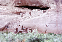
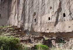
In the Pueblo phases, beginning in Pueblo I (750-950), they built houses above ground with kivas, circular underground chambers, constructed for ceremonial purposes. The Ancient Pueblo culture is perhaps best-known for the stone and adobe cliff dwellings built along cliff walls, particularly during the Pueblo II and Pueblo III eras. These villages were often only accessible by rope or through rock climbing.
By around 1300 C.E. (beginning of Pueblo IV period) the Ancient Pueblo communities were abandoned, probably due to a convergence of factors, and the people moved south and east. They created new communities, using adobe to a greater extent, and their culture continued to flourish until the Spanish explorers arrived. It was the Spanish who called their communities pueblos.
Art
Ancestral Puebloans are known for their pottery. In general, pottery was used for cooking or storage and was unpainted gray, either smooth or textured. From about 500 to 1300 C.E. in the northern part of the region, the most common decorated pottery had black painted designs on white or light gray backgrounds. Decoration was characterized by fine hatching, and contrasting colors were produced by the use of mineral-based paint on a chalky background. Tall cylinders are considered to have been ceremonial vessels, while narrow-necked jars may have been used for liquids. Ware in the southern portion of the region, particularly after 1150 C.E., was characterized by heavier black-line decoration and the use of carbon-based colorants.[7] In northern New Mexico, the local "black on white" tradition, the Rio Grande white wares, continued well after 1300 C.E.
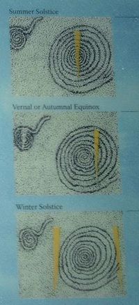
The Ancestral Puebloans also created many petroglyphs and pictographs. The best known petroglyph is the "Sun Dagger" on the Fajada Butte at which a glint of sunlight passes over a spiral petroglyph.[8] The location of the dagger on the petroglyph varies throughout the year. At the summer solstice a dagger-shaped light form pierces through the heart of the spiral; similar sun daggers mark the winter solstice and the equinoxes. It has been proposed that this petroglyph was created to mark these events.[8]
At two other sites on Fajada Butte, located a short distance below the Sun Dagger site, five petroglyphs are also marked by visually compelling patterns of shadow and light that indicate solar noon distinctively at the solstices and equinoxes.[8]
Architecture
The Ancestral Puebloan People crafted a unique architecture with planned community spaces. The ancient population centers for which the Ancestral Puebloans are renowned consisted of apartment-like complexes and structures (called pueblos by the Spanish explorers) made from stone, adobe mud, and other local material, or carved into the sides of canyon walls (cliff dwellings). These ancient towns and cities were usually multi-storied and multi-purposed buildings surrounding open plazas and were occupied by hundreds to thousands of Ancestral Puebloan People. These population complexes hosted cultural and civic events and infrastructure that supported a vast outlying region hundreds of miles away linked by roadways.
Constructed well before 1492 C.E., these Ancestral Puebloan towns and villages in the Southwestern U.S. were located in various defensive positions, for example, on high steep mesas such as at Mesa Verde or present-day Acoma "Sky City" Pueblo, in New Mexico. From before 900 C.E. and progressing past the thirteenth century, the population complexes were a major center of culture for the Ancient Pueblo Peoples. In Chaco Canyon, Chacoan developers quarried sandstone blocks and hauled timber from great distances, assembling fifteen major complexes which remained the largest buildings in North America until the nineteenth century.[9]
The best-preserved examples of the stone and adobe dwellings are in National Parks, such as Chaco Canyon or Chaco Culture National Historical Park, Mesa Verde National Park, Aztec Ruins National Monument, Bandelier National Monument, Hovenweep National Monument, and Canyon de Chelly National Monument.
- Cliff Dwellings
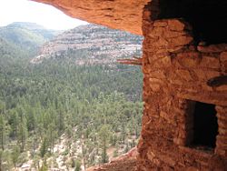
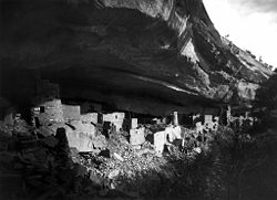
Throughout the southwest Ancient Puebloan region cliff dwellings, housing, defensive, and storage complexes were built in shallow caves and under rock overhangs along canyon walls. The structures contained within these alcoves were mostly blocks of hard sandstone, held together and plastered with adobe mortar. Adobe structures are constructed with bricks created from sand, clay, and water, with some fibrous or organic material, shaped using frames and dried in the sun. Specific constructions had many similarities, but were generally unique in form due to the individual topography of different alcoves along the canyon walls. In marked contrast to earlier constructions and villages on top of the mesas, the cliff dwellings at Mesa Verde reflected a region-wide trend towards the aggregation of growing regional populations into close, highly defensible quarters during the thirteenth century.
While much of the construction in these sites conforms to common Pueblo architectural forms, including Kivas, towers, and pit-houses, the space constrictions of these alcoves necessitated what seems to have been a far denser concentration of their populations. Mug House, a typical cliff dwelling of the period, was home to around 100 people who shared 94 small rooms and eight kivas built right up against each other and sharing many of their walls; builders in these areas maximized space in any way they could and no areas were considered off-limits to construction.[10]
Not all of the people in the region lived in cliff dwellings; many colonized the canyon rims and slopes in multi-family structures that grew to unprecedented size as populations swelled.[10] Decorative motifs for these sandstone/mortar constructions included T-shaped windows and doors. This has been taken by some archaeologists as evidence of the continuing reach of the Chaco Canyon elite system, which had seemingly collapsed around a century before.[11] Other researchers see these motifs as part of a more generalized Puebloan style and/or spiritual significance, rather than evidence of a continuing specific elite socioeconomic system.[12]
- Great Houses

Immense complexes known as "Great Houses" embodied worship at Chaco Canyon. As architectural forms evolved and centuries passed, the houses kept several core traits. Most apparent is their sheer bulk; complexes averaged more than 200 rooms each, and some enclosed up to 700 rooms.[13] Individual rooms were substantial in size, with higher ceilings than works of preceding Ancient Puebloan periods. They were well-planned: vast sections or wings erected were finished in a single stage, rather than in increments. Houses generally faced the south, and plaza areas were almost always girt with edifices of sealed-off rooms or high walls. Houses often stood four or five stories tall, with single-story rooms facing the plaza; room blocks were terraced to allow the tallest sections to compose the pueblo's rear edifice. Rooms were often organized into suites, with front rooms larger than rear, interior, and storage rooms or areas.
Ceremonial structures known as kivas were built in proportion to the number of rooms in a pueblo. One small kiva was built for roughly every 29 rooms. Nine complexes each hosted an oversized Great Kiva, each up to 63 feet (19 m) in diameter. T-shaped doorways and stone lintels marked all Chacoan kivas. Though simple and compound walls were often used, Great Houses were primarily constructed of core-and-veneer walls: two parallel load-bearing walls comprising dressed, flat sandstone blocks bound in clay mortar were erected. Gaps between walls were packed with rubble, forming the wall's core. Walls were then covered in a veneer of small sandstone pieces, which were pressed into a layer of binding mud.[9] These surfacing stones were often placed in distinctive patterns. The Chacoan structures altogether required the wood of 200,000 coniferous trees, mostly hauled—on foot—from mountain ranges up to 70 miles (110 km) away.[8][10]
Roads
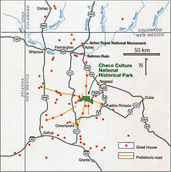
One of the most fascinating and intriguing aspects of Ancestral Puebloan infrastructure is the Chaco Road system. This is a system of roads radiating out from many great house sites such as Pueblo Bonito, Chetro Ketl and Una Vida, and leading towards small outlier sites and natural features within and beyond the canyon limits.
Through satellite images and ground investigations, archaeologists have detected at least eight main roads that together run for more than 180 miles (ca 300 km), and are more than 30 feet (10 m) wide. These were excavated into a smooth leveled surface in the bedrock or created through the removal of vegetation and soil. The Ancestral Puebloan residents of Chaco Canyon cut large ramps and stairways into the cliff rock to connect the roadways on the ridgetops of the canyon to the sites on the valley bottoms. The longest and most famous of these roads is the Great North Road, which originates from different routes close to Pueblo Bonito and Chetro Ketl. These roads converge at Pueblo Alto and from there lead north beyond the Canyon limits. There are no communities along the road's course, apart from small, isolated structures.
The economic purpose of the Chaco road system is shown by the presence of luxury items at Pueblo Bonito and elsewhere in the canyon. Items such as macaws, turquoise, marine shells, and imported vessels reveal the long-distance commercial relations Chaco had with other regions. The widespread use of timber in Chacoan constructions—a resource not locally available—also needed a large and easy transportation system. Through analysis of various strontium isotopes, archaeologists have realized that much of the timber that composes Chacoan construction came from a number of distant mountain ranges.
The Chaco road system may also have played a symbolic, ideological role linked to ancestral Puebloan beliefs. In fact, some archaeologists have suggested that the main purpose of the road system was a religious one, providing pathways for periodic pilgrimages and facilitating regional gatherings for seasonal ceremonies.
A religious explanation is supported by modern Pueblo beliefs about a North Road leading to their place of origin and along which the spirits of the dead travel. According to modern pueblo people, this road represents the connection to the shipapu, the place of emergence of the ancestors or a dimensional doorway. During their journey from the shipapu to the world of the living, the spirits stop along the road and eat the food left for them by the living.
Sparse concentrations of ceramic fragments along the North Road have been related to some sort of ritual activities carried out along the roadway. Isolated structures located on the roadsides as well as on top of the canyon cliffs and ridge crests have been interpreted as shrines related to these activities. Features such as long linear grooves were cut into the bedrock along certain roads which do not seem to point to a specific direction. It has been proposed that these were part of pilgrimage paths followed during ritual ceremonies.
Considering that some of these roads seem to go nowhere, it has been suggested that they can be linked—especially the Great North Road—to astronomical observations, solstice marking, and agricultural cycles.
Astronomy certainly played an important role in Chaco culture, as it is visible in the north-south axis alignment of many ceremonial structures. Many Chacoan buildings may have been aligned to capture the solar and lunar cycles,[14] requiring generations of astronomical observations and centuries of skillfully coordinated construction.[13] The main buildings at Pueblo Bonito, for example, are arranged according to this direction and probably served as central places for ceremonial journeys across the landscape. Other archaeoastronomical evidence has been found at Chaco, such as the Sun Dagger petroglyph at Fajada Butte.
Archaeologists agree that the purpose of this road system may have changed through time and that the Chaco Road system probably functioned for both economic and ideological reasons. Its significance for archaeology lies in the possibility to understand the rich and sophisticated cultural expression of ancestral Puebloan societies.
Notable Puebloan sites
- Anasazi State Park Museum
This state park and museum in Southern Utah features the reconstructed ruins of an ancient Anasazi village, referred to as the Coombs Village Site. It is the site of one of the largest Anasazi communities known to have existed west of the Colorado River and is believed to have been occupied from 1160 to 1235 C.E. As many as 250 people lived there.
- Aztec Ruins National Monument
Ancestral Pueblo structures in north-western New Mexico, close to the town of Aztec and northeast of Farmington, near the Animas River. The buildings date back to the eleventh to thirteenth centuries, and the misnomer attributing them to the Aztec civilization can be traced back to early American settlers in the mid-nineteenth century.
- Bandelier National Monument
A 33,677 acres (13,629 ha) National Monument preserving the homes of the Ancestral Pueblo People. It is named after Swiss anthropologist Adolph Bandelier, who researched the cultures of the area. The main attraction of the monument Frijoles Canyon, containing a number of ancestral pueblo homes, kivas, rock paintings, and petroglyphs. Some of the dwellings were rock structures built on the canyon floor; others were "cavates" produced by voids in the volcanic tuff of the canyon wall and carved out further by humans. These sites date from the Pueblo III (1150 to 1350) and Pueblo IV (1350 to 1600) periods. A visitor center features exhibits about the site's inhabitants, including Ancestral Pueblo pottery, tools, and artifacts of daily life.
- Canyon de Chelly National Monument
Located in northeastern Arizona within the boundaries of the Navajo Nation, this site preserves ruins of the early indigenous tribes that lived in the area, including the Ancient Pueblo Peoples and Navajo.
This National Historical Park, located in northwestern New Mexico between Albuquerque and Farmington, hosts the densest and most exceptional concentration of pueblos in the American Southwest. Between 900 and 1150 C.E., Chaco Canyon was a major center of culture for the Ancient Pueblo Peoples. There is significant archaeoastronomical evidence, such as the "Sun Dagger" petroglyph, at this site.
- Hovenweep National Monument
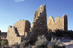
Straddling the Colorado-Utah border Northeast of Bluff, Utah, the Monument consists of six clusters of ruins. Between 1150 and 1200 C.E. the Hovenweep inhabitants, who are generally considered part of the Mesa Verde branch of the Ancient Pueblo Peoples, began building larger pueblos around fortress-like towers at the heads of box canyons. The people built dams and reservoirs and moved their fields into areas where water could be controlled. They also built large stone towers, living quarters, and other shelters to safeguard springs. Their stone course pueblos and towers exhibit expert masonry and engineering sjukks. The towers were built in a variety of shapes; D-shapes, squares, ovals, and circles. These stone pueblos were understandably referred to as "castles" by nineteenth-century explorers.
This National Park and UNESCO World Heritage Site is located in Montezuma County, Colorado; it was created in 1906 to protect some of the best preserved cliff dwellings in the world, including Cliff Palace, which is thought to be the largest cliff dwelling in North America. The Anasazi inhabited Mesa Verde between 550 to 1300 C.E. By 750 C.E., the people were building mesa-top villages made of adobe. By the late twelfth century they began to build the cliff dwellings for which Mesa Verde is famous.
Notes
- ↑ Linda S. Cordell, Ancient Pueblo Peoples (Washington DC: Smithsonian Books, 1994, ISBN 978-0895990389), 18-19.
- ↑ David D. Roberts, In Search of the Old Ones: Exploring the Anasazi World of the Southwest (New York, NY: Simon & Schuster, 1996, ISBN 978-0684810782).
- ↑ L. Michael Smith, Anasazi Hisatsinom: Sky Scraper Builders, 1998. Retrieved June 20, 2011.
- ↑ The first to surmise this was John Wesley Powell, Canyons of the Colorado (Flood & Vincent, 1985).
- ↑ Cordell, 142-143.
- ↑ George Johnson, "Social Strife May Have Exiled Ancient Indians", The New York Times (August 20, 1996). Retrieved June 23, 2011.
- ↑ Cordell, 98.
- ↑ 8.0 8.1 8.2 8.3 Anna Sofaer, Chaco Astronomy: An Ancient American Cosmology (Santa Fe, NM: Ocean Tree Books, 2007, ISBN 978-0943734460).
- ↑ 9.0 9.1 Brian M. Fagan, Chaco Canyon: Archaeologists Explore the Lives of an Ancient Society (New York, NY: Oxford University Press, 2005, ISBN 978-0195170436), 35.
- ↑ 10.0 10.1 10.2 John Kantner, Ancient Puebloan Southwest (Cambridge, England: Cambridge University Press, 2004, ISBN 978-0521788809), 161-166.
- ↑ Stephen H. Lekson, The Chaco Meridian: Centers of Political Power in the Ancient Southwest (Lanham, MD: AltaMira Press, 1999, ISBN 978-0761991816).
- ↑ David A. Phillips, Jr., "The Chaco Meridian: A skeptical analysis". In Mogollon Archaeology: Collected Papers from the Eleventh Mogollon Conference edited by Patrick H. Beckett, (Las Cruces, NM: COAS Publishing and Research, 2002), 189–214. Retrieved June 26, 2011.
- ↑ 13.0 13.1 Anna Sofaer, "The Primary Architecture of the Chacoan Culture: A Cosmological Expression." In Anasazi Architecture and American Design, edited by Baker H. Morrow and V. B. Price (Albuquerque, NM: University of New Mexico Press, 1997, ISBN 978-0826317797)
- ↑ Brian M. Fagan, From Black Land to Fifth Sun: The Science of Sacred Sites (New York, NY: Basic Books, 1998, ISBN 978-0201959918).
ReferencesISBN links support NWE through referral fees
- Childs, Craig. House of Rain: Tracking a Vanished Civilization Across the American Southwest. New York, NY: Little, Brown and Company, 2007. ISBN 978-0316608176
- Cordell, Linda S. Ancient Pueblo Peoples. Washington DC: Smithsonian Books, 1994. ISBN 978-0895990389
- Fagan, Brian M. Ancient North America: The Archaeology of a Continent. New York, NY: Thames and Hudson, Inc., 1995. ISBN 978-0500050750
- Fagan, Brian M. Chaco Canyon: Archaeologists Explore the Lives of an Ancient Society. New York, NY: Oxford University Press, 2005. ISBN 978-0195170436
- Fagan, Brian M. From Black Land to Fifth Sun: The Science of Sacred Sites. New York, NY: Basic Books, 1998. ISBN 978-0201959918
- Jennings, Jesse D. Glen Canyon: An Archaeological Summary. Salt Lake City, UT: University of Utah Press, 1998. ISBN 978-0874805840
- Kantner, John. Ancient Puebloan Southwest. Cambridge, England: Cambridge University Press, 2004. ISBN 978-0521788809
- Kidder, Alfred V. An Introduction to the study of Southwestern Archaeology. New Haven, CT: Yale University Press, 2000. ISBN 978-0300082975
- LeBlanc, Steven A. Prehistoric Warfare in the American Southwest. Salt Lake City, UT: University of Utah Press, 1999. ISBN 978-0874805819
- Lekson, Stephen H. The Chaco Meridian: Centers of Political Power in the Ancient Southwest. Lanham, MD: AltaMira Press, 1999. ISBN 978-0761991816
- Plog, Stephen. Ancient Peoples of the American Southwest. London: Thames and Hudson, 1997. ISBN 978-0500279397
- Pritzker, Barry M. A Native American Encyclopedia. New York, NY: Oxford University Press, 2000. ISBN 978-0195138771
- Roberts, David D. In Search of the Old Ones: Exploring the Anasazi World of the Southwest. New York, NY: Simon & Schuster, 1996. ISBN 978-0684810782
- Sofaer, Anna. "The Primary Architecture of the Chacoan Culture: A Cosmological Expression." In Anasazi Architecture and American Design, edited by Baker H. Morrow and V. B. Price. Albuquerque, NM: University of New Mexico Press, 1997. ISBN 978-0826317797
- Sofaer, Anna. Chaco Astronomy: An Ancient American Cosmology. Santa Fe, NM: Ocean Tree Books, 2007. ISBN 978-0943734460
- Toll, Catherine M., and H. Wolcott Toll. "Deciphering the Organization of Production in Chaco Canyon (Organization of Production at Chaco Canyon conference papers)." American Antiquity 66 (1) (Jan 2001): 5.
- Waldman, Carl. Encyclopedia of Native American Tribes. New York, NY: Checkmark Books, 2006. ISBN 978-0816062744
- Waldman, Carl. Atlas of the North American Indian. New York, NY: Checkmark Books, 2009. ISBN 978-0816068593
External links
All links retrieved July 26, 2023.
- Bandelier National Monument Museum Collections, from National Park Service
- Chaco Culture National Historic Park, from National Park Service
- Chaco Culture World Heritage Convention
- The Anasazi: The People of the Mountains, Mesas and Grasslands
- The Chaco Meridian
- Oral Tradition and History of the Ancient People
- In the Cliffs of Mesa Verde
- Aztec Ruins National Monument
- Hovenweep National Monument
- Anasazi State Park Museum
- Canyon de Chelly National Monument
Credits
New World Encyclopedia writers and editors rewrote and completed the Wikipedia article in accordance with New World Encyclopedia standards. This article abides by terms of the Creative Commons CC-by-sa 3.0 License (CC-by-sa), which may be used and disseminated with proper attribution. Credit is due under the terms of this license that can reference both the New World Encyclopedia contributors and the selfless volunteer contributors of the Wikimedia Foundation. To cite this article click here for a list of acceptable citing formats.The history of earlier contributions by wikipedians is accessible to researchers here:
The history of this article since it was imported to New World Encyclopedia:
Note: Some restrictions may apply to use of individual images which are separately licensed.
