Difference between revisions of "British Virgin Islands" - New World Encyclopedia
Mary Anglin (talk | contribs) m (→Culture) |
Mary Anglin (talk | contribs) m (→Geography) |
||
| Line 68: | Line 68: | ||
In addition to the four main islands other, smaller islands include: Beef Island, Cooper Island, Ginger Island, Great Camanoe, Great Thatch, Guana Island, Moskito Island, Necker Island, Norman Island, Peter Island and Salt Island. Of the 36 islands in the group, 20 are uninhabited. | In addition to the four main islands other, smaller islands include: Beef Island, Cooper Island, Ginger Island, Great Camanoe, Great Thatch, Guana Island, Moskito Island, Necker Island, Norman Island, Peter Island and Salt Island. Of the 36 islands in the group, 20 are uninhabited. | ||
| − | An extension of the central mountains of [[Puerto Rico]], the islands form a geological unit with Puerto Rico and the [[Greater Antilles]]. Of volcanic origin overlaid with [[limestone]], they have a variety of physical features. Most of them have a hilly, rugged terrain, except for Anegada | + | An extension of the central mountains of [[Puerto Rico]], the islands form a geological unit with Puerto Rico and the [[Greater Antilles]]. Of volcanic origin overlaid with [[limestone]], they have a variety of physical features. Most of them have a hilly, rugged terrain, except for Anegada - the only coral atoll in the group - which is fairly flat. There are low–lying mountains, lagoons with [[coral]] reefs and barrier beaches. Harbors tend to be landlocked. The islands have strong ties with the nearby [[U.S. Virgin Islands]] as well as with [[Puerto Rico]]. |
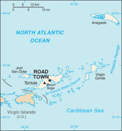
[[Image:BritishVirginIsland map.png|thumb|left|250px|Map of British Virgin Islands]] | [[Image:BritishVirginIsland map.png|thumb|left|250px|Map of British Virgin Islands]] | ||
Revision as of 23:01, 24 October 2007
| British Virgin Islands | |||||
| |||||
| Motto: "Vigilate" (Latin) "Be Watchful" | |||||
| Anthem: God Save the Queen | |||||
| Capital | Road Town | ||||
|---|---|---|---|---|---|
| Official languages | English | ||||
| Government | Overseas territory | ||||
| - Head of State | Queen Elizabeth II | ||||
| - Governor | David Pearey | ||||
| - Chief Minister | Orlando Smith | ||||
| UK overseas territory | |||||
| - Separate colony | 1960 | ||||
| - Autonomous territory | 1967 | ||||
| Area | |||||
| - Total | 153 km² (216th) 59 sq mi | ||||
| - Water (%) | 1.6 | ||||
| Population | |||||
| - 2005 census | 22,016 | ||||
| - Density | 260/km² 673/sq mi | ||||
| Currency | U.S. dollar (USD)
| ||||
| Time zone | Q (UTC-4) | ||||
| - Summer (DST) | not observed (UTC-4) | ||||
| Internet TLD | .vg | ||||
| Calling code | +1 (284) | ||||
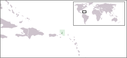
The British Virgin Islands (BVI) is a British overseas territory, located in the Caribbean to the east of Central America. The islands make up half of the Virgin Islands archipelago, the other half consists the U.S. Virgin Islands. With a total land mass of 95 miles² with 49.7 miles of coastline and a maritime claim of 3 nautical miles, but 200 nautical miles of exclusive fishing zones, the archipelago makes for a relaxing secluded get-away. Most of the islands are made of volcanic origin, the others are made from limestone and coral.
The British Virgin Islands consist of the main islands of Tortola, Virgin Gorda, Anegada and Jost Van Dyke, along with over fifty other smaller islands and cays. Around fifteen of the islands are inhabited. On the largest island of Tortola, the capitol of Road Town sits as the main stay and tourist area, although some tourists to venture to see other islands, but always return. The islands have a total population of about 22,000.
The islands extend from west to east for about 60 miles and are located west of the Anegada Passage, a major channel connecting the Atlantic Ocean and the Caribbean Sea.
Geography
The British Virgin Islands are comprised of 36 semi-tropical Caribbean islands, ranging in size from the largest, Tortola, approximately 12 miles by 3 miles, to tiny uninhabited islets. The four main islands are Tortola, Virgin Gorda, Anegada, and Jost Van Dyke. They are located in the Virgin Islands archipelago which forms the northeastern extremity of the Greater Antilles, and are to the immediate northeast of the U.S. Virgin Islands. The Atlantic Ocean surrounds the islands on the north and east, while the Caribbean Sea lies to the south and west, with the island of Puerto Rico also to its west.
In addition to the four main islands other, smaller islands include: Beef Island, Cooper Island, Ginger Island, Great Camanoe, Great Thatch, Guana Island, Moskito Island, Necker Island, Norman Island, Peter Island and Salt Island. Of the 36 islands in the group, 20 are uninhabited.
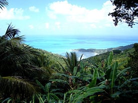
An extension of the central mountains of Puerto Rico, the islands form a geological unit with Puerto Rico and the Greater Antilles. Of volcanic origin overlaid with limestone, they have a variety of physical features. Most of them have a hilly, rugged terrain, except for Anegada - the only coral atoll in the group - which is fairly flat. There are low–lying mountains, lagoons with coral reefs and barrier beaches. Harbors tend to be landlocked. The islands have strong ties with the nearby U.S. Virgin Islands as well as with Puerto Rico.
The British Virgin Islands comprise an area slightly smaller that the U.S. District of Colombia. The total area of the colony is 59 square miles (153 square km), with 48 miles of coastline and a maritime claim of 3 nautical miles, and 200 nautical miles of exclusive fishing zones. Its highest point is Mount Sage on the island of Tortola, at 1,709.3 ft above sea level.
There are no rivers on the islands and natural resources are negligable. Twenty percent of the land is considered arable. Agriculture consists of various fruits, vegetables, livestock, and poultry.
Climate
The British Virgin Islands enjoy a tropical climate, moderated by trade winds. Temperatures vary little throughout the year. In the capital, Road Town, typical daily maxima are around 90°F in the summer and 84°F in the winter. Typical daily minima are around 75°F in the summer and 70°F in the winter.
Rainfall averages 45 inches per year, and is higher in the hills and lower on the coast. Rainfall can be quite variable, but the wettest months on average are from September to November and the driest months tend to be February and March. Hurricanes occasionally hit the islands, with the hurricane season running from June to October, and are seen as the only natural hazard to the area.
History
The Virgin Islands were first settled by Arawak Indians from South America around 100 B.C.E. (though there is some evidence of American Indian presence on the islands as far back as 1,500 B.C.E.). [1] The Arawaks inhabited the islands until the fifteenth century when they were displaced by the more aggressive Caribs, a tribe from the Lesser Antilles islands, after whom the Caribbean Sea is named. (Some historians, however, believe that this popular account of warlike Caribs chasing peaceful Arawaks out of the Caribbean islands is rooted in simplistic European stereotypes, and that the true story is more complex.)
The first European sighting of the Virgin Islands was by Christopher Columbus in 1493 on his second voyage to the Americas. Columbus gave them the fanciful name Santa Ursula y las Once Mil Vírgenes (Saint Ursula and her 11,000 Virgins), shortened to Las Vírgenes (The Virgins), after the legend of Saint Ursula.
The Spanish Empire acquired the islands in the early sixteenth century, mining copper on Virgin Gorda. Subsequent years saw the English, Dutch, French, Spanish and Danish all jostling for control of the region, which became a notorious haunt for pirates. During the process of colonization the native American Indian population was decimated through disease and mistreatment.
The Dutch established a permanent settlement on the island of Tortola in 1648. In 1672, the English captured Tortola from the Dutch, and the British annexation of Anegada and Virgin Gorda followed in 1680. Meanwhile, over the period 1672–1733, the Danish gained control of the nearby islands of St. Thomas, St. John and St. Croix.
The islands were considered principally a strategic possession, but were planted when economic conditions were particularly favorable. The British introduced sugar cane which was to become the main crop and source of foreign trade, and slaves were brought from Africa to work on the plantations. The islands prospered economically until the growth in the sugar beet crop in Europe and the United States significantly reduced sugar cane production.
In 1917, the United States purchased St. John, St. Thomas and St. Croix from Denmark for US$25 million, renaming them the U.S. Virgin Islands. Subsequently, the British renamed the islands they controlled as the British Virgin Islands.
The British Virgin Islands were administered variously as part of the Leeward Islands Colony or with St. Kitts and Nevis, with an Administrator representing the British Government on the Islands. Separate colony status was gained for the Islands in 1960 and the Islands became autonomous in 1967. Since the 1960s, the Islands have diversified away from their traditionally agriculture-based economy towards tourism and financial services, becoming one of the richest areas in the Caribbean.
Politics
Executive authority in the British Virgin Islands is vested in the royal monarch of United Kingdom and is exercised by the Governor of the British Virgin Islands. The Governor is appointed by the Monarch on the advice of the British Government. The Defense and Foreign Affairs remain the responsibility of the United Kingdom.
The Constitution of the Islands was introduced in 1971 and made by an Order in Council under powers granted by the West Indies Act of 1962. Ratified in 1971, it has been amended many times, first in 1979 then in 1982, 1991, 1994 and 2000. A new constitution was made in 2007 (the Virgin Islands Constitution Order 2007) and will come into force on the next date when the Legislative Council is dissolved for a general election.
The Head of Government is the Chief Minister, who is elected in a general election along with the other members of the ruling government as well as the members of the opposition, much like the United States presidential elections. An Executive Council is nominated by the Chief Minister and appointed by the Governor. There is a unicameral Legislative Council made up of 13 elected members who serve four-year terms.
Economy
The British Virgin Islands enjoys one of the more prosperous economies of the Caribbean region, with a per capita Gross Domestic Product (GDP) of around $38,500 in a 2004 estimate. [2] The 1995 unemployment was 3 percent, one of the lowest in the world.
The economy consists mainly of what is termed the "twin pillars" – tourism and financial services, though light industry is also important. Politically, tourism is the more important of the two pillars, as it employs a greater number of people within the Territory, and a larger proportion of the businesses in the tourist industry are locally owned, as are a number of the highly tourism-dependent sole traders such as taxi drivers and street vendors. The islands are a popular destination for U.S. citizens, with around 350,000 tourists visiting annually. Tourists frequent the numerous white sand beaches, visit The Baths on Virgin Gorda, snorkel the coral reefs near Anegada, experience the well-known bars of Jost Van Dyke, or charter yachts to explore the less accessible islands.
Economically, however, financial services is by far the more important. Nearly 50 percent of the Government's revenue comes directly from license fees for offshore companies, and considerable further sums are raised directly or indirectly from payroll taxes relating to salaries paid within the trust industry sector (which tend to be higher on average than those paid in the tourism sector). Substantial revenues are also generated by the registration of offshore companies. As of 2004, over 550,000 companies were registered. In 2000 KPMG reported in its survey of offshore jurisdictions for the UK government that over 41 percent of the world's offshore companies were formed in the British Virgin Islands. Since 2001, the Islands' financial services have been regulated by the independent Financial Services Commission.
Agriculture, once the backbone of the islands' economy, accounts for only a small proportion of the GDP. Agricultural produce includes fruit, vegetables, sugar cane, livestock and poultry. Some crops are exported, but most are grown for local consumption.
Commercial fishing is a growing industry and fresh fish have become a significant export. Industries include rum distillation, construction and boat building. Cottage industries produce woven baskets and other items that appeal to the tourist trade.
Since 1959, the official currency of the British Virgin Islands has been the US dollar, also used by the U.S. Virgin Islands.
The British Virgin Islands are a major target for drugs traffickers, who use the area as a gateway to the United States. According to the Foreign & Commonwealth Office, drugs trafficking is "potentially the most serious threat to stability in the BVI". [3]
Transport
Being a small group of islands, transportation is limited, with only 70 miles of roads (in comparison there are more than 100 miles of park trails in New York City). The main airport, Terrance B. Lettsome International Airport also known as Beef Island Airport, is located on Beef Island, which lies off the eastern tip of Tortola. Virgin Gorda and Anegada have their own smaller airports. The main harbor is in Road Town.
Demographics
The 2005 census showed a population of just over 22,000. The majority of the population (83 percent) are African-Caribbean, descended from the slaves brought to the islands by the British. Other large ethnic groups include those of British and other European origin. As of a 1999 census report 7.3 percent of the population was white, originating from Great Britain, Portugal and Syria/Lebanon. Also living on the Islands are mixed heritage peoples (5.4 percent), East Indian (3.14 percent), and less than one percent of other ancestry.
The islands are predominantly Protestant Christian at 86 percent. The largest individual denominations are Methodist with 33 percent, Anglican at 17 percent and Catholic with 10 percent.
Culture
Virgin Islander culture is syncretic, based primarily on African and European cultural influences. Though the Danish controlled the present-day U.S. Virgin Islands for many years, the dominant language has been an English-based Creole since the 19th century, and the islands remain much more receptive to English language popular culture than any other.
The Dutch, the French and the Danish also contributed elements to the island's culture, as have immigrants from the Arab world, India and other Caribbean islands. The single largest influence on modern Virgin Islander culture, however, comes from the Africans enslaved to work in canefields from the 17th to the mid-19th century. These African slaves brought with them traditions from across a wide swathe of Africa, including what is now Nigeria, Senegal, both Congos, Gambia and Ghana. [4]
Music
The music of the Virgin Islands reflects long-standing cultural ties to the island nations to the south as well as to various European colonialists. Though the U.S. Virgin Islands and British Virgin Islands are politically separate, they maintain close cultural ties. From its neighbors, the Virgin Islands has imported various pan-Caribbean genres of music, including calypso from Trinidad and reggae from Jamaica.
The traditional music of the British Virgin Islands is called fungi after the local cornmeal dish with the same name, often made with okra. The special sound of fungi is due to a unique local fusion between African and European music. It functions as a medium of local history and folklore and is therefore a cherished cultural form of expression that is part of the curriculum in British Virgin Island (BVI) schools. The fungi bands, also called "scratch bands", use instruments ranging from the calabash, washboard, bongos and the ukulele, to more traditional western instruments like the keyboard, banjo, guitar, bass, triangle and saxophone. Apart from being a form of festive dance music, fungi often contains humorous social commentaries, as well as oral history.
There are Virgin Islander institutions that support and promote the islands' folk heritage. Bradley Christian's St. Croix Heritage Dancers, for example, are folkloric group, one of several quadrille ensembles that offer a "compact, staged rendition" of folk traditions, along with educational narration.
Music education in the Virgin Islands is primarily based around the Western classical tradition, particularly orchestral and concert band music. Local folk music is also a part of the music curriculum; quadrilles are taught in schools in St. Croix, and Charlotte Amalie High School on St. Thomas is home to a well-known student scratch band.
Notes
- ↑ Wilson, Samuel M. ed. 1997.The Indigenous People of the Caribbean. Gainesville: University Press of Florida. ISBN 0813016924
- ↑ The World Factbook, CIA publications. Economy: British Virgin Islands. Retrieved October 24, 2007.
- ↑ UK Foreign & Commonwealth Office. September 5, 2007. British Virgin Islands Country Profile Retrieved October 24, 2007.
- ↑ Olsen, Dale A., and Daniel Edward Sheehy. 1998. The Garland encyclopedia of world music. Volume 2, South America, Mexico, Central America, and the Caribbean. (New York: Garland Pub.) pp 968-974
ReferencesISBN links support NWE through referral fees
- United Nations Decolonization Unit, Department of Politcal Affairs. Non-Self-Governing Territories listed by General Assembly in 2002 Retrieved October 24, 2007.
- Pearson Education, publishing as Infoplease. British Virgin Islands Retrieved October 24, 2007.
- Olsen, Dale A., and Daniel Edward Sheehy. 1998. The Garland encyclopedia of world music. Volume 2, South America, Mexico, Central America, and the Caribbean. New York: Garland Pub. ISBN 9780824049478
- Wilson, Samuel M. ed. The Indigenous People of the Caribbean. Gainesville: University Press of Florida, 1997. ISBN 0813016924
- The U.S. & British Virgin Islands 2007. 2006. Fodor's. New York: Fodor's. ISBN 9781400017140
- Maurer, Bill. 1997. Recharting the Caribbean land, law, and citizenship in the British Virgin Islands. Ann Arbor: University of Michigan Press. ISBN 0472108115
- Farnsworth, Paul. 2001. Island lives historical archaeologies of the Caribbean. Tuscaloosa: University of Alabama Press. ISBN 0817310932
External links
Official sites
- Government Site. Government of the Virgin Islands (U.K.). Retrieved October 11, 2007.
- Official Tourist Website. The British Virgin Islands Nature's Little Secrets. Retrieved October 11, 2007.
- Online Tourist Guide. The British Virgin Islands Welcome Tourist Guide On-line. Retrieved October 11, 2007.
- Sea Transportation of BVI. The British Virgin Islands Ports Authority. Retrieved October 11, 2007.
- Mission: To Preserve and Manage Natural and Cultural Areas in BVI. National Parks Trust of the British Virgin Islands. Retrieved October 11, 2007.
- Regulatory Financial and Business Services. British Virgin Islands Financial Services Commission. Retrieved October 11, 2007.
News and media
- News Page. B.V.I. Platinum News. Retrieved October 11, 2007.
- News Page. BVI News Online. Retrieved October 11, 2007
- Local Newspaper. The Island Sun. Retrieved October 11, 2007.
- Online News Source. The BVI Beacon. Retrieved October 11, 2007.
- News Site Online. The Virgin Islands Stand Point Online. Retrieved October 11, 2007.
- British Virgin Islands Vacation Guide. Trip Travel Guide. Retrieved October 11, 2007.
Directories
- British Virgin Islands dmoz open directory project. Retrieved October 11, 2007.
- British Virgin Islands Paradise Islands. Retrieved October 11, 2007.
Credits
New World Encyclopedia writers and editors rewrote and completed the Wikipedia article in accordance with New World Encyclopedia standards. This article abides by terms of the Creative Commons CC-by-sa 3.0 License (CC-by-sa), which may be used and disseminated with proper attribution. Credit is due under the terms of this license that can reference both the New World Encyclopedia contributors and the selfless volunteer contributors of the Wikimedia Foundation. To cite this article click here for a list of acceptable citing formats.The history of earlier contributions by wikipedians is accessible to researchers here:
- British_Virgin_Islands history
- Geography_of_the_British_Virgin_Islands history
- Music_of_the_Virgin_Islands history
The history of this article since it was imported to New World Encyclopedia:
Note: Some restrictions may apply to use of individual images which are separately licensed.


