|
|
| (80 intermediate revisions by 5 users not shown) |
| Line 1: |
Line 1: |
| | + | {{Images OK}}{{Submitted}}{{Approved}}{{Copyedited}} |
| | {{Infobox Settlement | | {{Infobox Settlement |
| | |official_name = City of Phoenix | | |official_name = City of Phoenix |
| | |settlement_type = City | | |settlement_type = City |
| − | |nickname = Valley of the Sun ''(official)'', The Valley, Phoenix Valley, PHX, The 602 | + | |nickname = Valley of the Sun ''(official),'' The Valley, Phoenix Valley, PHX, The 602 |
| | |website = http://www.phoenix.gov/ | | |website = http://www.phoenix.gov/ |
| | |image_skyline = Phoenix skyline.jpg | | |image_skyline = Phoenix skyline.jpg |
| Line 34: |
Line 35: |
| | |area_water_km2 = 0.6 | | |area_water_km2 = 0.6 |
| | |population_as_of = 2007 | | |population_as_of = 2007 |
| − | |population_footnotes =<ref name="popest">"[http://phoenix.gov/CITYGOV/stats.html]." ''United States Census Bureau.'' 2005. Retrieved on June 27, 2007.</ref><ref name="06EST">{{cite web|url=http://www.census.gov/Press-Release/www/2007/cb07-91table1.pdf|format=PDF|title=Population Estimates for the 25 Largest U.S. Cities based on July 1, 2006 Population Estimates}}</ref><ref name="2007popest">{{cite web|url=http://www.census.gov/popest/cities/tables/SUB-EST2007-04-04.csv|title=Annual Estimates of the Population for Incorporated Places in Arizona|publisher=United States Census Bureau|date=2008-07-10|accessdate=2008-07-14}}</ref> | + | |population_footnotes =<ref name="popest">''City of Phoenix.'' November 10, 2008. [http://phoenix.gov/CITYGOV/stats.html Community Trends and Profile] Retrieved November 19, 2008.</ref><ref name="06EST">''US Census Bureau''. June 28, 2007. Population Estimates for the 25 Largest U.S. Cities based on July 1, 2006 Population Estimates.</ref> |
| | |population_total = 1552259 (US rank : 5th) | | |population_total = 1552259 (US rank : 5th) |
| | |population_urban = 3,393,000 | | |population_urban = 3,393,000 |
| Line 50: |
Line 51: |
| | |area_code = 602, 480, 623 | | |area_code = 602, 480, 623 |
| | |GNIS_id = 44784 | | |GNIS_id = 44784 |
| − | |latd = 33 |latm = 26 |lats = 54 |latNS = N | + | |latd = 33 |latm = 27 |latNS = N |
| − | |longd = 112 |longm = 04 |longs = 26 |longEW = W | + | |longd = 112 |longm = 04 |longEW = W |
| | |elevation_m = 340 | | |elevation_m = 340 |
| | |elevation_ft = 1117 | | |elevation_ft = 1117 |
| Line 62: |
Line 63: |
| | |footnotes = | | |footnotes = |
| | }} | | }} |
| − | '''Phoenix''' is the largest and most populous city in the state of Arizona. It is also the state capital and the largest state capital in the United States in terms of population. Phoenix is the only state capital with a population of more than a million people. It is also the county seat of Maricopa County.{{GR|6}} It is the largest city in the Mountain Time Zone as well as the second largest city in the [[Western United States]] after [[Los Angeles, California]]. It is the region's primary cultural, economic, and financial center. It is also major national transportation hub. Phoenix is located on the banks of what is now the normally dry Salt River (with the exception of Tempe Town Lake). The city was incorporated on February 25 1881. The city's metropolitan area is also known by its nickname, "The Valley of the Sun" or the shortened "The Valley," because the city is surrounded by mountains on all sides. Residents of the city are known as Phoenicians. | + | '''Phoenix''' is the largest and most populous [[city]] in the state of [[Arizona]], and is the only state capital with a population of more than a million people. It is also the county seat of Maricopa County and the second largest city in the [[Western United States]] after [[Los Angeles, California]]. It is the fifth largest city in the United States in terms of population (2008), and the tenth largest for land area in the [[United States]] at {{convert|517|sqmi|km2}}. It is the region's primary [[culture|cultural]], [[economics|economic]], and [[finance|financial]] center and a major [[transportation]] hub. |
| | | | |
| − | The city is currently the fifth largest city in the United States<ref name="06EST"/> in terms of population with a 2007 estimated population of 1,552,259. Its city proper is the tenth largest for land area in the [[United States]] at {{convert|517|sqmi|km2}}. As of 2008, the Phoenix Metropolitan Statistical Area (MSA) was the thirteenth largest in the United States, with an estimated population of 4,579,427.
| + | Phoenix, incorporated in 1881, is located on the banks of what is now the normally dry Salt River. The city's metropolitan area is also known by its nickname, "The Valley of the Sun" or simply "The Valley," because the city is surrounded by [[mountain]]s on all sides. Its location among the mountains, combined with [[desert]] weather patterns, however, contributes to a cloud of [[pollution]] that hangs over the city, trapped by the air currents that prevail. The city that was once a haven for those suffering from respiratory ailments is today forced to take active measures in reducing [[pollution]]. |
| − | | + | {{toc}} |
| − | ==History==
| + | The [[Hohokam]] peoples occupied the land that became Phoenix for more than 1000 years. They created roughly 135 miles of [[irrigation]] [[canal]]s, making the [[desert]] land arable before finally leaving the area following long periods of [[drought]] and severe [[flood]]s. The modern city's founder had a series of canals built that followed those of the ancient [[Native American]] system and the city grew up around them. This gave rise to the city's name: "Phoenix" was decided upon because it describes a city born from the ruins of a former [[civilization]]. Paths of the original Hohokam canals were later used for the modern Arizona Canal, Central Arizona Project Canal, and the Hayden-Rhodes Aqueduct. |
| − | ===Native American Period===
| |
| − | For more than 1,000 years, the [[Hohokam]] peoples occupied the land that would become Phoenix.<ref name="EARLY">"[http://phoenix.gov/CITYGOV/history.html#EARLY Out of the Ashes, Early Life along the Salt River]." ''[http://www.phoenix.gov/ City of Phoenix].'' Retrieved on November 26, 2006.</ref> The Hohokam created roughly 135 miles (217 km) of irrigation canals, making the desert land arable. Paths of these canals would later become used for the modern Arizona Canal, Central Arizona Project Canal, and the Hayden-Rhodes Aqueduct. The Hohokam also carried out extensive trade with nearby [[Anasazi]], Mogollon, and other Mesoamerican tribes.
| |
| − | | |
| − | It is believed that, between 1300 and 1450, periods of drought and severe floods led to the Hohokam's abandonment of the area.<ref name="EARLY"/> Local Akimel O'odham settlements, thought to be the descendants of the formerly urbanized Hohokam, concentrated on the Gila River alongside those of the [[Tohono O'odham]] and Maricopa peoples. Some family groups did continue to live near the Salt River, but no large villages existed.
| |
| − | | |
| − | ===Hispanic Period===
| |
| − | | |
| − | Father Eusebio Kino, an [[Italy|Italian]] [[Jesuit]] in the service of the [[Spanish Empire]], was among the first Europeans to travel here in the 1600s and 1700s. By this time, the valley was within the territory of New Spain, which was controlled by Spain and later independent [[Mexico]]. Father Kino named the river "Rio Salado" (Salt River) due to the water's high mineral content. He interacted with the few native peoples who remained in the valley but focused mostly on the [[Pima]] missions established in southern Arizona as well as exploring other parts of the Southwest and California. Only southern Arizona experienced the full influence of Hispanic cultures – the Salt River Valley itself remained almost depopulated for several centuries.
| |
| − | | |
| − | ===Early United States period===
| |
| − | American and European "Mountain Men" likely came through the area while exploring what is now central Arizona during the early 19th century. They obtained valuable [[beaver]] and [[otter]] pelts; these animals, as well as [[deer]] and [[wolf|wolves]], often lived in the Salt River Valley when water supplies and temperatures allowed.
| |
| − | | |
| − | When the [[Mexican-American War]] ended in 1848, most of Mexico's northern zone passed to [[United States]] control and a portion of it was made the New Mexico Territory (this included what is now Phoenix) shortly afterward. The [[Gadsden Purchase]] was completed in 1853. The land was contested ground during the [[American Civil War]]. Both the Confederate Arizona Territory, organized by Southern sympathizers in 1861 and with its capital in [[Tucson]], and the United States Arizona Territory, formed by the [[U.S. Congress]] in 1863, with its capital at Fort Whipple (now Prescott, Arizona) included the Salt River Valley within their borders. The valley was not militarily important, however, and did not witness conflict.
| |
| − | | |
| − | In 1863, the mining town of Wickenburg was the first to be established in what is now Maricopa County. At the time this county did not exist, as the land was within Yavapai County along with the other major town of Prescott.
| |
| − | | |
| − | The [[U.S. Army]] created Fort McDowell on the Verde River in 1865 to quell Native American uprisings. Hispanic workers serving the fort established a camp on the south side of the Salt River by 1866 that was the first permanent settlement in the valley after the decline of the Hohokam. In later years, other nearby settlements would form and merge to become the city of Tempe,<ref>[http://www.tempe.gov/museum/Tempe_history/basics/timeline.htm#FIRST Tempe history timeline]." 1866 entry discussing early farm camp. ''[http://www.tempe.gov/museum Tempe Historical Museum].'' Retrieved on January 20, 2008.</ref> but this community was incorporated after Phoenix.
| |
| − | | |
| − | ===Founding of Phoenix===
| |
| − | The history of Phoenix as a city begins with Jack Swilling, an [[American Civil War]] veteran who had come west to seek wealth in the 1850s and worked primarily in Wickenburg. On an outing in 1867, he stopped to rest at the foot of the White Tank Mountains. Swilling observed the abandoned river valley and considered its potential for farming, much like that already cultivated by the military further east near Fort McDowell. The [[terrain]] and [[climate]] were optimal; only a regular source of water was necessary. The existence of the old [[Hohokam]] ruins, showing clear paths for canals, made Swilling imagine new possibilities.
| |
| − | | |
| − | Swilling had a series of [[canal]]s built which followed those of the ancient [[Native Americans in the United States|Native American]] system. A small community formed that same year about 4 miles (6 km) east of the present city. It was first called Pumpkinville due to the large [[pumpkin]]s that flourished in fields along the canals, then Swilling's Mill in his honor, though later renamed to Helling Mill, Mill City, and finally, East Phoenix. Swilling, a former [[Confederate States Army|Confederate]] soldier, wanted to name the city "Stonewall," after [[Stonewall Jackson|General Stonewall Jackson]]. Others suggested the name of "Salina." However, neither name was supported by the community.
| |
| − | | |
| − | Finally, Lord Darrell Duppa suggested the name "Phoenix," as it described a city born from the ruins of a former civilization.<ref>"[http://phoenix.gov/CITYGOV/history.html#BORN Out of the Ashes, Phoenix is Born]." ''[http://www.phoenix.gov/ City of Phoenix].'' Retrieved on November 26, 2006.</ref>
| |
| − | | |
| − | The Yavapai County Board of Supervisors, which at the time encompassed Phoenix, officially recognized the new town on May 4, 1868, and formed an election precinct. The first post office was established on June 15, 1868, with Jack Swilling serving as the postmaster. With the number of residents growing (the 1870 U.S. census reported about a total Salt River Valley population of 240), a townsite needed to be selected. On October 20 1870, the residents held a meeting to decide where to locate it. A 320-acre (1.3 km²) plot of land was purchased in what is now the downtown business section.<ref>"[http://phoenix.gov/CITYGOV/history.html#SELECT Out of the Ashes, Selecting a Townsite]." ''[http://www.phoenix.gov/ City of Phoenix].'' Retrieved on November 26, 2006.</ref>
| |
| − | | |
| − | On February 12 1871, the territorial legislature created Maricopa County, the sixth one formed, by dividing Yavapai County. The first election for county office was held in 1871, when Tom Barnum was elected the first sheriff. Barnum ran unopposed as the other two candidates, John A. Chenowth and Jim Favorite, had a shootout that ended in Favorite's death and Chenowth withdrawing from the race.<ref name="SALE">"[http://phoenix.gov/CITYGOV/history.html#SALE Out of the Ashes, The Great Sale]." ''[http://www.phoenix.gov/ City of Phoenix].'' Retrieved on November 26, 2006.</ref>
| |
| − | | |
| − | Several lots of land were sold in 1870 at an average price of $48. The first church opened in 1871, as did the first store. Public school had its first class on September 5, 1872, in the courtroom of the county building. By October 1873, a small school was completed on Center Street (now Central Avenue).<ref name="SALE" /> Land entry was recorded by the Florence Land Office on November 19 1873, and a declaratory statement filed in the Prescott Land Office on February 15 1872. President [[Ulysses S. Grant]] issued a land patent for the present site of Phoenix on April 10 1874. The total value of the Phoenix Townsite was $550, with downtown lots selling for between $7 and $11 each. A short time later, a [[telegraphy|telegraph]] office, 16 [[bar (establishment)|saloons]], four dance halls and two banks were open.<ref>"[http://phoenix.gov/CITYGOV/history.html#WORTH Out of the Ashes, Whole Town Worth $550]."
| |
| − | ''[http://www.phoenix.gov/ City of Phoenix].'' Retrieved on November 26, 2006.</ref>
| |
| − | | |
| − | [[Image:Phoenix1885-AerialMap HiRes.jpg|thumb|left|Aerial lithograph of Phoenix from 1885]] | |
| − | | |
| − | ===Incorporation===
| |
| − | By 1881, Phoenix had outgrown its original townsite-commissioner form of government. The 11th Territorial Legislature passed "The Phoenix Charter Bill," incorporating Phoenix and providing for a mayor-council government. The bill was signed by Governor [[John C. Fremont]] on February 25 1881. Phoenix was incorporated with a population of approximately 2,500, and on May 3 1881, Phoenix held its first city election. Judge John T. Alsap defeated James D. Monihon, 127 to 107, to become the city's first mayor.<ref>"[http://phoenix.gov/CITYGOV/history.html#INC Out of the Ashes, Incorporation in 1881]." ''[http://www.phoenix.gov/ City of Phoenix].'' Retrieved on November 26, 2006.</ref> In early 1888, the city offices were moved into the new City Hall, at Washington and Central (later the site of the city bus terminal, until Central Station was built in the 1990s). This building also provided temporary offices for the territorial government when it moved to Phoenix in 1889.<ref
| |
| − | name="TRANS">"[http://phoenix.gov/CITYGOV/history.html#TRANS Out of the Ashes, Transportation: Horses and Rails]." ''[http://www.phoenix.gov/ City of Phoenix].'' Retrieved on November 26, 2006.</ref>
| |
| − | | |
| − | The coming of the railroad in the 1880s was the first of several important events that revolutionized the economy of Phoenix. Merchandise now flowed into the city by rail instead of wagon. Phoenix became a trade center with its products reaching eastern and western markets. In response, the Phoenix Chamber of Commerce was organized on November 4 1888.<ref name="TRANS" />
| |
| − | | |
| − | Phoenix also inaugurated an [[Phoenix Street Railway|electric streetcar system]], built off earlier stagecoach lines, in 1891.
| |
| − | | |
| − | ===Modern Phoenix (1900-Present)===
| |
| − | [[Image:Phoenix1908.jpg|thumb|320px|left|Central Avenue, Phoenix, Arizona, 1908]]
| |
| − | In 1902, President [[Theodore Roosevelt]] signed the [[Newlands Reclamation Act|National Reclamation Act]] allowing for dams to be built on western streams for reclamation purposes. Residents were quick to enhance this by organizing the Salt River Valley Water Users' Association on February 7, 1903, to manage the water and power supply. The agency still exists as part of the [[Salt River Project]].<ref>"[http://www.srpnet.com/about/history/timeline.aspx SRP: Historical timeline]." ''[http://www.srpnet.com/ Salt River Project].'' Retrieved on November 30, 2006.</ref> The Roosevelt Dam east of the valley was completed in 1911. Several new lakes were formed in the surrounding mountain ranges. In the Phoenix area, the river dried out, taking with it the large populations of migrating birds, beaver dams, and [[cottonwood]] trees that had lived on its waters.
| |
| − | | |
| − | On February 14 1912, under President [[William Howard Taft]], Phoenix became the capital of the newly formed [[United States state|state]] of Arizona.<ref>"[http://phoenix.gov/CITYGOV/history.html#ROOS Out of the Ashes, Roosevelt and Reclamation]." ''[http://www.phoenix.gov/ City of Phoenix].'' Retrieved on November 26, 2006.</ref>
| |
| − | | |
| − | Phoenix was considered preferable as both territorial and state capital due to its more central location as compared to Tucson or Prescott. It was smaller than Tucson but outgrew that city within the next few decades to become the state's largest.
| |
| − | | |
| − | In 1913, Phoenix adopted a new form of government from [[Mayor-Council government|mayor-council]] to [[Council-Manager government|council-manager]], making it one of the first cities in the United States with this form of city government.<ref>"[http://phoenix.gov/CITYGOV/history.html#ESTABLISH Out of the Ashes, Establishing a Council-Manager Government]." ''[http://www.phoenix.gov/ City of Phoenix].'' Retrieved on November 26, 2006.</ref>
| |
| − | | |
| − | [[Image:Phoenix in 1900.jpg|thumb|right|Phoenix in the early 20th century]]
| |
| − | During [[World War II]], Phoenix's economy shifted to that of a distribution center, rapidly turning into an embryonic industrial city with mass production of military supplies. [[Luke Air Force Base|Luke Field]], [[Williams Air Force Base|Williams Field]], and [[Falcon Field (Arizona)|Falcon Field]], coupled with the giant ground-training center at [[Hyder, Arizona|Hyder]], west of Phoenix, brought thousands of new people into Phoenix.<ref name="GROW">"[http://phoenix.gov/CITYGOV/history.html#GROW Out of the Ashes, Growing into a Metropolis]." ''[http://www.phoenix.gov/ City of Phoenix].'' Retrieved on November 26, 2006.</ref>
| |
| − | | |
| − | The Papago Park [[Prisoner of War]] Camp was established for internment of Japanese-Americans. Only a few of its former buildings remain today. In 1944, dozens of prisoners had devised a plan to escape from the camp and use boats to go down the Salt and Gila Rivers to reach Mexico. They were apparently unaware that the Salt River had been dry for decades and were thus easily apprehended near the camp.
| |
| − | | |
| − | Another notorious incident took place on [[Thanksgiving]] night of 1942, when a large number of U.S. troops stationed near Phoenix rioted while resisting arrest by military police due to engaging in a fight. The military police surrounded and blocked off a predominantly [[African American]] part of the city that the troops had escaped to in order to hide. They then dispersed armored personnel carriers{{Fact|date=March 2008}} and used 50-caliber machine guns on civilian homes. Several fatalities resulted. The Colonel of Luke Field soon declared Army personnel banned from Phoenix, which pressured civic leaders to reform local government by firing a number of corrupt officials, in turn getting the ban lifted. This same bipartisan effort also successfully convinced the city council to give more power to the city manager to run the government and spend public funds.
| |
| − | | |
| − | A fire in October 1947 destroyed most of the [[Phoenix Street Railway|streetcar]] fleet, making the city choose between implementing a new street railway system or using buses. The latter were selected, and automobiles remained the city's preferred method of transportation.
| |
| − | | |
| − | By 1950, over 100,000 people lived within the city and thousands more in surrounding communities. There were 148 miles (238 km) of paved streets and 163 miles (262 km) of unpaved streets.<ref name="GROW"/>
| |
| − | | |
| − | Over the next several decades, the city and metropolitan area attracted more growth. Nightlife and civic events concentrated along Central Avenue. By the 1970s, however, there was rising crime and a decline in business within the downtown core.
| |
| − | | |
| − | [[Image:Phoenix.skyline.750pix.jpg|thumb|left|250px|The Phoenix skyline.]]
| |
| − | [[Arizona Republic]] writer [[Don Bolles]] was murdered by a car bomb in the city in 1976. It was believed that his investigative reporting on [[organized crime]] in Phoenix made him a target. Bolles' last words referred to Phoenix land and cattle magnate Kemper Marley, who was widely regarded to have ordered Bolles' murder, as well as John Harvey Adamson, who pleaded guilty to second-degree murder in 1977 in return for testimony against contractors Max Dunlap and James Robison. Dunlap was convicted of first degree murder in the case in 1990 and remains in prison, while Robison was acquitted, but pleaded guilty to charges of soliciting violence against Adamson. [[Street gangs]] and the [[drug trade]] had turned into public safety issues by the 1980s. Van Buren Street, East of downtown (near 24th St), became associated with [[prostitution]]. The city's crime rates in many categories have improved since that time, but still exceed state and national averages.
| |
| − | | |
| − | After the Salt River flooded in 1980 and damaged many bridges, the [[Arizona Department of Transportation]] and [[Amtrak]] worked together and temporarily operated a train service, the "Hattie B." line, between central Phoenix and the southeast suburbs. It was discontinued because of high operating costs and a lack of interest from local authorities in maintaining funding.<ref>"[http://archive.azrail.org/azrail/hattieb/index.htm#SALTTRAIN The 1980 "Hattie B." Flood Relief Train]." Retrieved on January 19, 2008.</ref>
| |
| − | | |
| − | The "[[Phoenix Lights]]" sightings took place in March 1997. The [[Baseline Killer]] and [[Serial Shooter]] crime sprees occurred in Phoenix, Tempe, and Mesa. Steele Indian School Park was the site of a [[2007 Phoenix news helicopter collision|mid-air collision between two news helicopters]] in July 2007.
| |
| − | | |
| − | Phoenix has maintained a massive growth streak in recent years, growing by 24.2% since 2000. This makes it the second-fastest-growing [[metropolitan area]] in the [[United States]] following only [[Las Vegas metropolitan area|Las Vegas]], whose population has grown by 29.2% since 2000.<ref>In Pictures: America's Fastest-Growing Cities from [http://www.forbes.com/2007/10/31/property-cities-growth-forbeslife-cx_mw_1031realestate_slide_3.html?thisSpeed=15000]</ref>
| |
| | | | |
| | ==Geography== | | ==Geography== |
| − | [[Image:Phoenix.landsat.750pix.jpg|thumb|left|[[Landsat 7]] Satellite image of the Phoenix Metro Area in 2002.]] | + | [[Image:Phoenix.landsat.750pix.jpg|thumb|left|200px|[[Landsat 7]] Satellite image of the Phoenix Metro Area in 2002.]] |
| − | Phoenix is located at 33°26'54" North, 112°4'26" West (33.448457°, -112.073844°){{GR|1}} in the Salt River Valley, or "Valley of the Sun," in central Arizona. It lies at a mean elevation of 1,117 feet (340 m), in the northern reaches of the [[Sonoran Desert]]. | + | Phoenix is located in the [[Salt River Valley]], or "Valley of the Sun," in central [[Arizona]]. It lies at a mean elevation of 1,117 feet (340 m), in the northern reaches of the [[Sonoran Desert]]. According to the United States Census Bureau, the city has a total area of 475.1 square miles (1,230.5 km²). |
| − | | |
| − | The [[Salt River (Arizona)|Salt River]] course runs westward through the city of Phoenix; the riverbed is normally dry except when excess runoff forces the release of water from the six dams upriver. The city of Tempe has built two inflatable dams in the Salt River bed to create a year-round recreational lake, called [[Tempe Town Lake]]. The dams are deflated to allow the river to flow unimpeded during releases. [[Lake Pleasant Regional Park]] is located in Northwest Phoenix.
| |
| | | | |
| − | The Phoenix area is surrounded by the [[McDowell Mountains]] to the northeast, the [[White Tank Mountain Regional Park|White Tank Mountains]] to the west, the [[Superstition Mountains]] far to the east, and the [[Sierra Estrella]] to the southwest. Within the city are the [[Phoenix Mountains]] and [[South Mountains (Arizona)|South Mountains]]. Current development (as of 2005) is pushing beyond the geographic boundaries to the north and west, and south through Pinal County. According to the [[United States Census Bureau]], the city has a total area of 475.1 square miles (1,230.5 km²); 474.9 square miles (1,229.9 km²) of it is land and 0.2 square miles (0.6 km², or 0.05%) of it is water. | + | The [[Salt River]] course runs westward through the city of Phoenix; the riverbed is normally dry except when excess runoff forces the release of [[water]] from the six [[dam]]s upriver. The city of [[Tempe, Arizona|Tempe]] has built two inflatable dams in the Salt River bed to create a year-round recreational lake, called Tempe Town Lake. The dams are deflated to allow the river to flow unimpeded during releases. Lake Pleasant Regional Park is located in Northwest Phoenix. |
| | | | |
| − | The Phoenix [[Metropolitan Statistical Area|Metropolitan Statistical Area (MSA)]] (officially known as the Phoenix-[[Mesa, Arizona|Mesa]]-[[Scottsdale, Arizona|Scottsdale]] MSA), is the [[List of United States metropolitan areas|13th largest]] in the United States, with a total population of 4,039,182 as of the June 2006 update of the 2000 [[U.S. Census]]. It includes the Arizona counties of [[Maricopa County, Arizona|Maricopa]] and [[Pinal County, Arizona|Pinal]]. Other cities in the MSA include Mesa, Scottsdale, [[Glendale, Arizona|Glendale]], [[Tempe, Arizona|Tempe]], [[Chandler, Arizona|Chandler]], [[Gilbert, Arizona|Gilbert]], and [[Peoria, Arizona|Peoria]]. Several smaller communities are also included, such as [[Cave Creek, Arizona|Cave Creek]], [[Queen Creek, Arizona|Queen Creek]], [[Buckeye, Arizona|Buckeye]], [[Goodyear, Arizona|Goodyear]], [[Fountain Hills, Arizona|Fountain Hills]], [[Litchfield Park, Arizona|Litchfield Park]], [[Anthem, Arizona|Anthem]], | + | The Phoenix area is surrounded by the McDowell Mountains to the northeast, the White Tank Mountains to the west, the Superstition Mountains far to the east, and the Sierra Estrella to the southwest. Within the city are the Phoenix Mountains and South Mountains. Development is pushing beyond the geographic boundaries to the north and west, and south through Pinal County. |
| − | [[Sun Lakes, Arizona|Sun Lakes]], [[Sun City, Arizona|Sun City]], [[Sun City West, Arizona|Sun City West]], [[Avondale, Arizona|Avondale]], [[Surprise, Arizona|Surprise]], [[El Mirage, Arizona|El Mirage]], [[Paradise Valley, Arizona|Paradise Valley]], and [[Tolleson, Arizona|Tolleson]]. The communities of [[Ahwatukee]], [[Arcadia Neighborhood|Arcadia]], Deer Valley, [[Laveen, Arizona|Laveen]], Maryvale and others are part of the city of Phoenix, Ahwatukee being separated from the rest of the city by South Mountain.
| |
| | | | |
| − | As with most of Arizona, Phoenix does not observe [[daylight saving time]]. In 1973, Gov. Jack Williams argued to [[United States Congress|Congress]] that energy use would increase in the evening, as refrigeration units were not used as often in the morning on standard time. He went on to say that energy use would rise "because there would be more lights on in the early morning." He was also concerned about children going to school in the dark, which indeed they were.<ref>"[http://www.azstarnet.com/sn/printDS/75798 Arizona does not need daylight saving time]." ''[http://www.azstarnet.com/ Arizona Daily Star].'' Published on May 19, 2005. Retrieved on December 15, 2006.</ref> The exception to this are lands of the Navajo Nation in Northeastern Arizona, which observe daylight saving time in conjunction with the rest of their tribal lands in other states.
| + | However, its location among the [[mountain]]s and the weather patterns of the [[desert]] have combined to create what is known as the "Brown Cloud." Particles of [[carbon]] and [[nitrogen dioxide]] gas are trapped by the air currents that prevail, creating a cloud of [[pollution]]. While Phoenix at one time was known as a haven for those suffering from ailments such as [[allergy|allergies]], [[asthma]], and [[tuberculosis]], in 2005 the American Lung Association gave Maricopa County its lowest grade for air quality in both [[ozone]] and particulates.<ref>Steve Eastwood. January 2006. Brown Air in the Valley ''About.com''.</ref> |
| | | | |
| | ===Climate=== | | ===Climate=== |
| − | {{climate chart
| + | [[Image:Phoenix from North Mt Preserve.jpg|thumb|right|250px|Phoenix from North Mt. Preserve]] |
| − | |[[Phoenix]]
| + | [[Image:Papago Buttes 3.jpg|right|thumb|Hole-in-the-Rock, a natural geological formation in Papago Park]] |
| − | |45|67|.83
| + | Phoenix has an [[arid]] climate, with very hot summers and temperate winters. The average summer high [[temperature]] is among the hottest of any populated area in the United States and approaches those of cities such as [[Riyadh]] and [[Baghdad]]. The temperature reaches or exceeds 100°F (38°C) on an average of 89 days during the year, including most days from early June through early September. On June 26, 1990, the temperature reached an all-time recorded high of 122°F (50°C).<ref>''National Oceanic and Atmospheric Administration''. [http://www.wrh.noaa.gov/psr/general/history/index.php?page=100deg Facts about 100 Degree Temperatures at Phoenix] Retrieved November 19, 2008.</ref> |
| − | |48|71|.77 | |
| − | |51|76|1.07 | |
| − | |58|85|.25
| |
| − | |67|94|.16 | |
| − | |75|104|.09
| |
| − | |81|107|.99
| |
| − | |80|105|.94
| |
| − | |75|99|.75
| |
| − | |63|88|.79
| |
| − | |50|75|.73
| |
| − | |44|70|.92
| |
| − | |source=Weather.com / NWS
| |
| − | |float=left
| |
| − | |clear=left
| |
| − | |units=imperial
| |
| − | }}
| |
| − | Phoenix has an [[arid]] climate, with very hot summers and temperate winters. The average summer high temperature is among the hottest of any populated area in the United States and approaches those of cities such as [[Riyadh]] and [[Baghdad]]. The temperature reaches or exceeds 100 °[[Fahrenheit|F]] (38 °[[Celsius|C]]) on an average of 89 days during the year, including most days from early June through early September. On June 26 1990, the temperature reached an all-time recorded high of 122°F (50°C).<ref>"[http://www.wrh.noaa.gov/psr/general/history/index.php?page=100deg Phoenix 100 Degree Temperature Facts]." ''[http://www.wrh.noaa.gov/psr/ National Weather Service - Phoenix].'' Retrieved on December 15, 2006.</ref> | |
| | | | |
| − | Overnight lows greater than {{convert|80|°F|°C|abbr=on}} occur frequently each summer, with the average July low being {{convert|83|°F|°C|abbr=on}} and the average August low being {{convert|82|°F|°C|abbr=on}}. The all-time highest low temperature ever recorded was 96°F (36°C), which occurred on July 15 2003.
| + | Precipitation is sparse during a large part of the summer, but the influx of [[monsoon]]al moisture, which generally begins in early July and lasts until mid-September, raises humidity levels and can cause heavy localized precipitation and flooding. Winter months are mild to warm, with daily high temperatures ranging from the mid-60s to low 70s, and low temperatures rarely dipping below 40. |
| | | | |
| − | Precipitation is sparse during a large part of the summer, but the influx of [[monsoon]]al moisture, which generally begins in early July and lasts until mid-September, raises humidity levels and can cause heavy localized precipitation and flooding. Winter months are mild to warm, with daily high temperatures ranging from the mid-60's to low 70's, and low temperatures rarely dipping below 40.
| + | Phoenix averages 85 percent of possible sunshine and receives scant rainfall, the average annual total being 8.3 inches (210 mm). March is the wettest month of the year (1.07 inches or 27 mm) with June being the driest (0.09 inches or 2 mm). Although [[thunderstorm]]s are possible at any time of the year, they are most common during the monsoon from July to mid-September as humid air surges in from the [[Gulf of California]]. Winter storms moving inland from the [[Pacific Ocean]] occasionally produce significant [[rain]]s but occur infrequently. On average, Phoenix has only 5 days per year where the temperature drops to or below freezing.<ref>''National Climatic Data Center''. June 4, 2004. [http://lwf.ncdc.noaa.gov/oa/climate/online/ccd/min32temp.html Mean Number of Days With Minimum Temperature {{convert|32|°F|°C|abbr=on}} or Less] Retrieved November 19, 2008.</ref> The all-time lowest recorded temperature in Phoenix was 16°F (-8.8°C) on January 7, 1913. [[Snow]] is extremely rare in the area. |
| − | [[Image:Phoenix from North Mt Preserve.jpg|thumb|right|250px|Phoenix from North Mt Preserve.]]
| |
| − | Phoenix averages 85% of possible sunshine<ref>[http://geography.asu.edu/cerveny/wxpart4.htm#sun2 WXPART4<!-- Bot generated title —>]</ref> and receives scant rainfall, the average annual total at [[Phoenix Sky Harbor International Airport]] being 8.3 [[inch]]es (210 mm). March is the wettest month of the year (1.07 inches or 27 mm) with June being the driest (0.09 inches or 2 mm). Although thunderstorms are possible at any time of the year, they are most common during the monsoon from July to mid-September as humid air surges in from the [[Gulf of California]]. These can bring strong winds, large [[hail]], or rarely, [[tornado]]es. Winter storms moving inland from the [[Pacific Ocean]] occasionally produce significant rains but occur infrequently. Fog is rare but can be observed from time to time during the winter months. | |
| | | | |
| − | On average, Phoenix has only 5 days per year where the temperature drops to or below freezing.<ref>[http://lwf.ncdc.noaa.gov/oa/climate/online/ccd/min32temp.html Mean Number of Days With Minimum Temperature {{convert|32|°F|°C|abbr=on}} or Less]. ''[[National Climatic Data Center]]''. June 23, 2004. Last Retrieved February 16, 2006.</ref> The long-term mean date of the first frost is December 15 and the last is February 1; however, these dates do not represent the city as a whole because the frequency of freezes increases the further one moves outward from the urban heat island. Frequently, outlying areas of Phoenix see frost, but the airport does not. The earliest frost on record occurred on November 3 1946, and the latest occurred on April 4, 1945. The all-time lowest recorded temperature in Phoenix was 16°F (-8.8°C) on January 7 1913.
| + | ===City parks === |
| | + | Many [[park]]s have been established to preserve the [[desert]] landscape in areas that would otherwise quickly be developed with commercial and residential zoning. The most noteworthy park is [[South Mountain Park]], the world's largest municipal park with {{convert|16500|acre|km2}}. The Desert Botanical Garden displays desert [[plant]]life from deserts all over the world. Encanto Park is the city's largest and primary urban park, and lies just northwest of downtown Phoenix. [[Papago Park]], named for the [[Papago]] Indians, in east Phoenix is home to both the [[Desert Botanical Garden]] and the Phoenix Zoo, as well as a few golf courses. |
| | | | |
| − | [[Snow]] is extremely rare in the area. Snowfall was first officially recorded in 1896, and since then, accumulations of 0.1 inches (0.25 cm) or greater have occurred only seven times. The heaviest snowstorm on record dates to January 20 1937 – January 21 1937, when 1 to {{convert|4|in|mm}} fell (2 to 10 cm) in parts of the city and did not melt entirely for four days. Before that, 1 inch (2.5 cm) had fallen on January 20, 1933. On February 2 1939, 0.5 inches (1 cm) fell. | + | ==History== |
| | + | ===Native American period=== |
| | + | For more than 1000 years, the [[Hohokam]] peoples occupied the land that would become Phoenix. The Hohokam created roughly 135 miles (217 km) of irrigation [[canal]]s, making the [[desert]] land arable. Paths of these canals would later be used for the modern Arizona Canal, Central Arizona Project Canal, and the Hayden-Rhodes Aqueduct. The Hohokam also carried out extensive [[trade]] with nearby [[Anasazi]], [[Mogollon]], and other [[Mesoamerican]] tribes. |
| | | | |
| − | Most recently, 0.4 inches (1 cm) fell on December 21 1990 – December 22 1990. Snow also fell on March 12 1917<nowiki>,</nowiki> November 28 1919, and December 11 1985.<ref>"[http://www.wrh.noaa.gov/psr/general/history/index.php?page=snow Phoenix Snowfall History]." ''[http://www.wrh.noaa.gov/psr/ National Weather Service - Phoenix].'' Retrieved on December 15 2006.</ref><ref>Source: U.S. National Climatic Data Center, Asheville, N.C.; a division of the National Oceanic and Atmospheric Administration</ref>
| + | It is believed that between 1300 and 1450 periods of [[drought]] and severe [[flood]]s led to the Hohokam's abandonment of the area. |
| | | | |
| − | ===Cityscape=== | + | ===Hispanic period=== |
| − | [[Image:Phoenix Urban Villages.svg|thumb|right|200px|Map of the [[urban village]]s of Phoenix]]
| |
| − | The city of Phoenix is divided up into 15 [[urban village]]s.<ref name="urbanvillages">"[http://phoenix.gov/PLANNING/vpcommtt.html Village Planning Committees]." ''[http://www.phoenix.gov/ Phoenix City Government].'' January 9, 2007. Retrieved on February 22, 2007.</ref> Inside some of the Villages are well-known neighborhoods, or districts, which are listed as subpoints. These urban villages are: [[Ahwatukee|Ahwatukee Foothills]], [[Alhambra, Phoenix, Arizona|Alhambra]], [[Camelback East, Phoenix, Arizona|Camelback East]], [[Central City, Phoenix, Arizona|Central City]], [[Deer Valley, Phoenix, Arizona|Deer Valley]] , [[Desert View, Phoenix, Arizona|Desert View]], [[Encanto, Phoenix, Arizona|Encanto]], [[Estrella, Phoenix, Arizona|Estrella]], [[Laveen, Phoenix, Arizona|Laveen]], [[Maryvale, Phoenix, Arizona|Maryvale]], [[North Gateway, Phoenix, Arizona|North Gateway]], [[North Mountain, Phoenix, Arizona|North Mountain]], [[Paradise Valley, Phoenix, Arizona|Paradise Valley]] (not to be confused with the town of [[Paradise Valley, Arizona|Paradise Valley]]), [[South Mountain, Phoenix, Arizona|South Mountain]] and [[Rio Vista, Phoenix, Arizona|Rio Vista]]. Rio Vista was created as New Village in 2004 and is currently very sparsely populated, with no large amount of
| |
| − | development expected in the near future.<ref name="urbanvillages2">"[http://phoenix.gov/PLANNING/vpriovista.html Village Planning Committees]." ''[http://www.phoenix.gov/ Phoenix City Government].'' March 21, 2008. Retrieved on April 15, 2008.</ref>
| |
| | | | |
| − | Commonly referred-to Phoenix regions and districts include [[Downtown Phoenix|Downtown]], [[Midtown, Phoenix, Arizona|Midtown]], [[West Phoenix]], [[North/Northwest Phoenix|North Phoenix]], [[South Phoenix]], [[Biltmore, Phoenix, Arizona|Biltmore Area]], [[Arcadia, Phoenix, Arizona|Arcadia]], [[Sunnyslope, Phoenix, Arizona|Sunnyslope]], [[Ahwatukee, Phoenix, Arizona|Ahwatukee]].
| + | Father [[Eusebio Kino]], an [[Italy|Italian]] [[Jesuit]] in the service of the [[Spanish Empire]], was among the first [[Europe]]ans to travel to the area in the 1600s and 1700s. By this time, the valley was within the territory of New Spain, which was controlled by [[Spain]] and later independent [[Mexico]]. Father Kino named the river "Rio Salado" (Salt River) due to the water's high mineral content. He interacted with the few native peoples who remained in the valley but focused mostly on the [[Pima]] missions established in southern [[Arizona]] as well as exploring other parts of the [[Southwestern United States|Southwest]] and [[California]]. Only southern Arizona experienced the full influence of Hispanic cultures; the Salt River Valley itself remained almost depopulated for several centuries. |
| | | | |
| − | ==Demographics== | + | ===Early United States period=== |
| | + | American and European "mountain men" likely came through the area while exploring what is now central Arizona during the early nineteenth century. They obtained valuable [[beaver]] and [[otter]] pelts; these animals, as well as [[deer]] and [[wolf|wolves]], often lived in the Salt River Valley when water supplies and temperatures allowed. |
| | | | |
| − | According to the 2000 [[census]], there were 1,321,045 people, 865,834 households, and 407,450 families residing in the city. The [[population density]] was 2,782 people per square mile (1,074/km²). There were 895,832 housing units at an average density of 1,044 per square mile (403/km²).
| + | When the [[Mexican-American War]] ended in 1848, most of Mexico's northern zone passed to [[United States]] control and a portion of it was made the [[New Mexico Territory]] (this included what is now Phoenix) shortly afterward. The [[Gadsden Purchase]] was completed in 1853. The land was contested ground during the [[American Civil War]]. Both the Confederate Arizona Territory, organized by Southern sympathizers in 1861 and with its capital in Tucson, and the United States Arizona Territory, formed by the [[U.S. Congress]] in 1863, with its capital at Fort Whipple (now Prescott, Arizona) included the Salt River Valley within their borders. The valley was not militarily important, however, and did not witness conflict. |
| | | | |
| − | There were 865,834 households out of which 35.7% had children under the age of 18 living with them, 46.9% were [[Marriage|married couples]] living together, 12.9% had a female householder with no husband present, and 34.0% were non-traditional families. 25.4% of all households were made up of individuals and 6.3% had someone living alone who was 65 years of age or older. The average household size was 2.79 and the average family size was 3.39.
| + | In 1863, the mining town of Wickenburg was the first to be established in what is now Maricopa County. |
| | | | |
| − | In the city the population age distribution was 28.9% under the age of 18, 10.9% from 18 to 24, 33.2% from 25 to 44, 18.8% from 45 to 64, and 8.1% who were 65 years of age or older. The median age was 31 years. For every 100 females there were 103.5 males. For every 100 females age 18 and over, there were 102.7 males.
| + | The [[U.S. Army]] created Fort McDowell on the Verde River in 1865 to quell [[Native American]] uprisings. Hispanic workers serving the fort established a camp on the south side of the Salt River by 1866 that was the first permanent settlement in the valley after the decline of the Hohokam. |
| | | | |
| − | The median income for a household in the city was $41,207, and the median income for a family was $46,467. Males had a median income of $32,820 versus $27,466 for females. The [[per capita income]] for the city was $19,833. 15.8% of the population and 11.5% of families were below the [[poverty line]]. Out of the total population, 21.0% of those under the age of 18 and 10.3% of those 65 and older were living below the poverty line. | + | ===Founding of Phoenix=== |
| | + | The history of Phoenix as a city begins with Jack Swilling, an [[American Civil War]] veteran who had come west to seek wealth in the 1850s and worked primarily in Wickenburg. On an outing in 1867, he stopped to rest at the foot of the White Tank Mountains. Swilling observed the abandoned river valley and considered its potential for farming. The [[terrain]] and [[climate]] were optimal; only a regular source of water was necessary. The existence of the old [[Hohokam]] ruins, showing clear paths for canals, made Swilling imagine new possibilities. |
| | + | [[Image:Phoenix1885-AerialMap HiRes.jpg|thumb|Aerial lithograph of Phoenix from 1885]] |
| | + | Swilling had a series of canals built that followed those of the ancient [[Native American]] system. A small community formed that same year about 4 miles (6 km) east of the present city. It was first called Pumpkinville due to the large [[pumpkin]]s that flourished in fields along the canals, then Swilling's Mill in his honor, though it was later renamed Helling Mill, Mill City, and finally, East Phoenix. Finally, the name "Phoenix" was suggested, as it describes a city born from the ruins of a former [[civilization]].<ref>''City of Phoenix''. [http://phoenix.gov/CITYGOV/history.html#BORN Out of the Ashes, Phoenix is Born]. Retrieved November 19, 2008.</ref> |
| | | | |
| − | As of 2000, the [[Race and ethnicity in the United States Census|racial]] makeup of the Phoenix was 71.1% [[White (U.S. Census)|White]], 5.1% [[African American (U.S. Census)|African American]], 2.0% [[Native American (U.S. Census)|Native American]], 2.0% [[Asian (U.S. Census)|Asian]], 0.13% [[Pacific Islander (U.S. Census)|Pacific Islander]], 16.4% from [[Race (U.S. Census)|other races]], and 3.3% from two or more races. 34.1% of the population were [[Hispanic (U.S. Census)|Hispanic]] or [[Latino (U.S. Census)|Latino]] of any race.<ref>[http://www.fedstats.gov/qf/states/04/0455000.html Phoenix (city) MapStats from FedStats]</ref> Since the 2000 census, the [[White American|non-Hispanic White]] population in Phoenix dropped below 50%, according to William Frey, a demographer with the [[Brookings Institution]].<ref>[http://www.washingtonpost.com/wp-dyn/content/article/2006/08/20/AR2006082000629.html Changing Face of Western Cities]</ref>
| + | The first [[post office]] was established in 1868. With the number of residents growing (the 1870 U.S. census reported about a total Salt River Valley population of 240), a town site needed to be selected. On October 20, 1870, the residents held a meeting to decide where to locate it. A 320-acre (1.3 km²) plot of land was purchased in what is now the downtown business section. |
| − |
| |
| − | In 2000, the Phoenix metro area's [[religion|religious]] composition was reported as 45% [[Catholic]], 13% [[The Church of Jesus Christ of Latter-day Saints|LDS]] (concentrated heavily in the suburb of [[Mesa, Arizona|Mesa]]) and 5% [[Jewish]]. The remaining 37% are largely members of [[Protestant]] denominations or are unaffiliated.<ref>Religion demographic data from [http://www.thearda.com/ The Association of Religion Data Archives].</ref>
| |
| − | {{USCensusPop
| |
| − | | 1890= 3152
| |
| − | | 1900= 5544
| |
| − | | 1910= 11314
| |
| − | | 1920= 29053
| |
| − | | 1930= 48118
| |
| − | | 1940= 65414
| |
| − | | 1950= 106818
| |
| − | | 1960= 439170
| |
| − | | 1970= 581572
| |
| − | | 1980= 789704
| |
| − | | 1990= 983403
| |
| − | | 2000= 1321045
| |
| − | | 2006= 1512986
| |
| − | | estimate=1552259
| |
| − | | estyear=2007
| |
| − | | estref=
| |
| − | | footnote=source:<ref>Gibson, Campbell. "[http://www.census.gov/popest/cities/tables/SUB-EST2007-01.csv]." ''[[Census Bureau]].'' July, 2007. Retrieved on July 1 2007.</ref>
| |
| − | }}
| |
| | | | |
| − | ==Economy==
| + | On February 12, 1871, the territorial legislature created Maricopa County. The first election for county office was held in 1871. The first [[church]] opened in 1871, as did the first store. Public [[school]] had its first class on September 5, 1872, in the courtroom of the county building. By October 1873, a small school was completed on Center Street (now Central Avenue). A short time later, a [[telegraphy|telegraph]] office, 16 saloons, four dance halls, and two banks were open. |
| − | [[Image:Phoenix AZ USA DownTown 001 2005 09 20.jpg|thumb|left|<center>Downtown Phoenix south of Jefferson Street </center>]] | |
| | | | |
| − | The early economy of Phoenix was primarily agricultural, dependent mainly on [[cotton]] and [[citrus]] farming. In the last two decades, the economy has diversified as swiftly as the population has grown. As the state capital of [[Arizona]], many residents in the area are employed by the government. [[Arizona State University]] has also enhanced the area's population through education and its growing research capabilities. Numerous high-tech and telecommunications companies have also recently relocated to the area. Due to the warm climate in winter, Phoenix benefits greatly from seasonal [[tourism]] and recreation, and has a particularly vibrant [[golf]] industry. | + | ===Incorporation=== |
| | + | By 1881, Phoenix had outgrown its original townsite-commissioner form of government. The 11th Territorial Legislature passed the Phoenix Charter Bill, incorporating Phoenix and providing for a mayor-council government. The bill was signed by Governor [[John C. Fremont]] on February 25, 1881. Phoenix was incorporated with a population of approximately 2500, and on May 3, 1881, Phoenix held its first city election. |
| | | | |
| − | Phoenix is currently home to seven major [[Fortune 1000]] companies: waste management company [[Allied Waste]], electronics corporation [[Avnet]], [[Apollo Group]] (which operates the [[University of Phoenix]]), mining company [[Freeport-McMoRan]] (recently merged with Phoenix based [[Phelps Dodge]]), retailer [[PetSmart]], energy supplier [http://www.pinnaclewest.com/main/pnw/home Pinnacle West] and retailer [[CSK Auto]]. [[Honeywell]]'s Aerospace division is headquartered in Phoenix, and the valley hosts many of their avionics and mechanical facilities. [[Intel]] has one of their largest sites here, employing about 10,000 employees and 3 chip manufacturing fabs, including the $3 billion state-of-the-art 300 mm and 45nm Fab 32. [[American Express]] hosts their financial transactions, customer information, and their entire website in Phoenix. The area is also home to [[US Airways Group]], a Fortune 500 company located in [[Tempe, Arizona|Tempe]] also home to [http://www.insight.com Insight Enterprises]
| + | The coming of the [[railway|railroad]] in the 1880s was the first of several important events that revolutionized the economy of Phoenix. Merchandise now flowed into the city by rail instead of wagon. Phoenix became a [[trade]] center, with its products reaching eastern and western markets. |
| − | (also listed on the Fortune 500). Phoenix is also home to the headquarters of [[U-HAUL]] International, a rental company and moving supply store, as well [[Best Western]], a [[hotel]] chain, is also headquartered in the city.
| |
| | | | |
| − | In recent years many Internet companies have found a home in Phoenix. Internet companies like eBay,Google, AOL, GoDaddy.com, IPowerWeb and Easynews all have major offices located in Phoenix.
| + | ===Modern Phoenix (1900-present)=== |
| | + | [[Image:Phoenix1908.jpg|thumb|320px|left|Central Avenue, Phoenix, Arizona, 1908]] |
| | + | In 1902, President [[Theodore Roosevelt]] signed the [[National Reclamation Act]] allowing for [[dam]]s to be built on western [[stream]]s for reclamation purposes. Residents were quick to enhance this by organizing the Salt River Valley Water Users' Association to manage the water and power supply. The agency still exists as part of the Salt River Project. The [[Roosevelt Dam]] east of the valley was completed in 1911. Several new [[lake]]s were formed in the surrounding [[mountain]] ranges. In the Phoenix area, the [[river]] dried out, taking with it the large populations of migrating [[bird]]s, [[beaver]]s, and [[cottonwood]] trees. |
| | | | |
| − | The military has a significant presence in Phoenix with [[Luke Air Force Base]] located in the western suburbs. At its height, in the 1940s, the Phoenix area had 3 military bases: Luke Field (still in use), [[Falcon Field (Arizona)|Falcon Field]], and [[Williams Air Force Base]] (now [[Phoenix-Mesa Gateway Airport]]), with numerous auxiliary air fields located throughout the region.
| + | In 1912, Phoenix became the capital of the newly formed state of Arizona. Phoenix was considered preferable as both territorial and state capital due to its more central location compared to Tucson or Prescott. It was initially smaller than Tucson but outgrew that city within the next few decades to become the state's largest. In 1913, Phoenix switched from mayor-council to [[council-manager]], making it one of the first cities in the United States with this form of city government. |
| | | | |
| − | :''See also: [[List of major corporations in Phoenix]]'' | + | [[Image:Phoenix in 1900.jpg|thumb|240px|Phoenix in the early twentieth century.]] |
| | + | [[Image:Phoenix.skyline.750pix.jpg|thumb|240px|The Phoenix skyline, 2001.]] |
| | + | During [[World War II]], Phoenix's economy shifted to that of a distribution center, rapidly turning into an embryonic industrial city with mass production of military supplies. Luke Field, Williams Field, and Falcon Field, coupled with the giant ground-training center at Hyder, west of Phoenix, brought thousands of new people into Phoenix. The Papago Park [[Prisoner of War]] Camp was established for [[Japanese Internment|internment]] of Japanese-Americans. Only a few of its former buildings remain today. |
| | | | |
| − | ==Culture==
| + | By 1950, over 100,000 people lived within the city and thousands more in surrounding communities. There were 148 miles (238 km) of paved streets and 163 miles (262 km) of unpaved streets. |
| − | Phoenix and the surrounding area is home to a broad range of cultural activities including the [[performing arts]], museums, and events.
| |
| | | | |
| − | ===Performing Arts===
| + | Over the next several decades, the city and metropolitan area attracted more growth. Nightlife and civic events concentrated along Central Avenue. By the 1970s, however, there was rising [[crime]] and a decline in business within the downtown core. |
| − | Several music venues take place around Arizona, but primarily in and around [[downtown Phoenix]] and in [[Scottsdale, Arizona|Scottsdale]]. One such venue is the [[Phoenix Symphony Hall]], where performances from groups such as [[Arizona Opera]] and [[Ballet Arizona]] often occur. Another venue is the [[Orpheum Theatre (Phoenix)]] which is home to the [[Phoenix Metropolitan Opera]]. [[Concert]]s also regularly make stops in the area. Venues for concerts include the [[US Airways Center]] in downtown Phoenix, [[Jobing.com Arena]] in [[Glendale, Arizona|Glendale]], and the Dodge theater (also in downtown Phoenix).
| |
| − | Since 2002, Phoenix has also seen a rapid growth in local arts through The Artlink Program. Several Smaller theatres including [[Trunk Space]], [[Space 55]] and [[Modified Arts]] support regular independent musical and theatre performances.
| |
| | | | |
| − | ===Museums===
| + | ''Arizona Republic'' writer [[Don Bolles]] was murdered by a car bomb in 1976. It was believed that his investigative reporting on [[organized crime]] in Phoenix made him a target. Bolles' last words referred to Phoenix land and cattle magnate Kemper Marley, who was widely regarded to have ordered Bolles' murder, as well as John Harvey Adamson, who pleaded guilty to second-degree murder in 1977 in return for testimony against contractors Max Dunlap and James Robison. Dunlap was convicted of first degree murder in the case in 1990 and remains in prison, while Robison was acquitted but pleaded guilty to charges of soliciting violence against Adamson. |
| − | Several [[museum]]s are scattered around the valley. One of the most well-known museums in the area is the [[Heard Museum]] just north of [[downtown Phoenix|downtown]]. It has over 130,000 square feet (12,000 m²) of gallery, classroom and performance space. Some of the signature exhibits include a full [[Navajo]] [[hogan]], the Mareen Allen Nichols Collection containing 260 pieces of contemporary jewelry, the [[Barry Goldwater]] Collection of 437 historic [[Hopi]] [[kachina]] dolls, and an exhibit on the 19th century boarding school experiences of Native Americans. The Heard Museum attracts about 250,000 visitors a year.
| |
| | | | |
| − | Other notable museums include the [[Arizona Science Center]], Fleischer Museum, Hall of Flame Firefighting Museum, Arizona Historical Society Museum, Phoenix Museum of History, the [[Phoenix Zoo]], and the Pueblo Grande Museum and Cultural Park.
| + | Street [[gang]]s and the [[drug trafficking|drug trade]] had turned into public safety issues by the 1980s. Van Buren Street, east of downtown, became associated with [[prostitution]]. The city's [[crime]] rates in many categories have improved since that time but still exceed state and national averages. |
| | | | |
| − | ===Fine Arts===
| + | Phoenix has maintained a massive growth streak in recent years, growing by 24.2 percent since 2000. This makes it the second-fastest-growing metropolitan area in the [[United States]] following only [[Las Vegas]], whose population has grown by 29.2 percent since 2000.<ref>Matt Woolsey. [http://www.forbes.com/2007/10/31/property-cities-growth-forbeslife-cx_mw_1031realestate_slide_3.html?thisSpeed=15000 In Pictures: America's Fastest-Growing Cities] ''Forbes''. Retrieved November 19, 2008.</ref> |
| − | The [[downtown Phoenix]] art scene has also developed significantly in the past decade. The Artlink organization and the multitude of galleries downtown have successfully launched a [[First Friday]] cross-Phoenix gallery opening.
| |
| | | | |
| − | ===Cuisine=== | + | ==Government== |
| − | Phoenix has long been renowned for authentic [[Mexican cuisine|Mexican food]], thanks to both the large [[hispanic]] population and proximity to [[Mexico]]. But the recent population boom has brought people from all over the nation, and to a lesser extent from other countries, and has since influenced the local cuisine. International food, such as [[Korean cuisine|Korean]], [[Cuisine of Brazil|Brazilian]], and [[French cuisine|French]], have become more common throughout the valley in recent years. However, Mexican food is arguably still the most popular food, with Mexican restaurants found all over the area.
| + | [[Image:Azcap.jpg|thumb|250px|The [[Arizona State Capitol]], which once housed the state legislature is now a museum.]] |
| | + | [[Image:Phoenix AZ USA DownTown 001 2005 09 20.jpg|thumb|Downtown Phoenix south of Jefferson Street]] |
| | + | Being the capital of [[Arizona]], Phoenix houses the state legislature. The city of Phoenix is served by a city council consisting of a mayor and eight city council members. The mayor is elected ''at large,'' to a four-year term. Phoenix City Council members are elected to four-year terms by voters in each of the eight separate districts that they represent. The mayor and city council members have equal voting power to adopt ordinances and set the policies that govern the city. |
| | | | |
| − | ==Sports==
| + | Phoenix operates under a council-manager form of government, with a strong city manager supervising all city departments and executing policies adopted by the council. |
| − | {| class="wikitable"
| |
| − | |-
| |
| − | !Club
| |
| − | !Sport
| |
| − | !League
| |
| − | !Venue
| |
| − | !Championships
| |
| − | |-
| |
| − | |[[Arizona Cardinals]]
| |
| − | |[[American Football|Football]]
| |
| − | |[[National Football League]] – [[National Football Conference|NFC]]
| |
| − | |[[University of Phoenix Stadium]]
| |
| − | |0
| |
| − | |-
| |
| − | |[[Arizona Diamondbacks]]
| |
| − | |[[Baseball]]
| |
| − | |[[Major League Baseball]] – [[National League]]
| |
| − | |[[Chase Field]]
| |
| − | |1
| |
| − | |-
| |
| − | |[[Phoenix Suns]]
| |
| − | |[[Basketball]]
| |
| − | |[[National Basketball Association]] – [[Western Conference (NBA)|Western Conference]]
| |
| − | |[[US Airways Center]]
| |
| − | |0
| |
| − | |-
| |
| − | |[[Phoenix Coyotes]]
| |
| − | |[[Ice Hockey]]
| |
| − | |[[National Hockey League]] – [[Western Conference (NHL)|Western Conference]]
| |
| − | |[[Jobing.com Arena]]
| |
| − | |0
| |
| − | |-
| |
| − | |[[Phoenix Mercury]]
| |
| − | |[[Basketball]]
| |
| − | |[[Women's National Basketball Association]]
| |
| − | |[[US Airways Center]]
| |
| − | |1
| |
| − | |-
| |
| − | |[[Arizona Rattlers]]
| |
| − | |[[Arena Football]]
| |
| − | |[[Arena Football League]]
| |
| − | |[[US Airways Center]]
| |
| − | |2
| |
| − | |-
| |
| − | |[[Phoenix RoadRunners]]
| |
| − | |[[Ice Hockey]]
| |
| − | |[[ECHL]]
| |
| − | |[[US Airways Center]]
| |
| − | |0
| |
| − | |-
| |
| − | |[[Tucson Scorpions]]
| |
| − | |[[MMA]]
| |
| − | |[[International Fight League]]
| |
| − | |[[Jobing.com Arena]]
| |
| − | |0
| |
| − | |-
| |
| − | |[[Phoenix Flame]]
| |
| − | |[[Basketball]]
| |
| − | |[[International Basketball League (2005-)|International Basketball League]]
| |
| − | |[[Arizona Veterans Memorial Coliseum]]
| |
| − | |0
| |
| − | |-
| |
| − | |[[Arizona Sting]]
| |
| − | |[[Lacrosse]]
| |
| − | |[[National Lacrosse League]]
| |
| − | |[[Jobing.com Arena]]
| |
| − | |0
| |
| − | |}
| |
| − | [[Image:AmericaWestArena.jpg|thumb|right|[[US Airways Center]] in [[downtown Phoenix]].]]
| |
| − | Phoenix is home to several professional sports franchises, including representatives of all four [[major professional sports league|major professional sports leagues in the U.S.]] The first major franchise was the [[Phoenix Suns]] of the [[National Basketball Association]] (NBA), which started play in 1968. In 1997, the [[Phoenix Mercury]] was one of the original eight teams to launch the [[Women's National Basketball Association]] (WNBA). Both teams play at U.S. Airways Center. The [[Phoenix Flame]] of the [[International Basketball League]] began play in the spring of 2007.
| |
| | | | |
| − | [[Image:Super Bowl XLII University of Phoenix Stadium.JPG|thumb|left|300px|[[University of Phoenix Stadium]] on the game day of [[Super Bowl XLII]] on February 3, 2008.]]
| + | ==Economy== |
| − | The [[Arizona Cardinals]] moved to Phoenix from [[St. Louis, Missouri]] in 1988 and currently play in the [[National Football League|NFL's]] [[National Football Conference]] – [[NFC West|West Division]]. The team, however, has never played in the city itself; they played at [[Sun Devil Stadium]] on the campus of [[Arizona State University]] in nearby [[Tempe, Arizona|Tempe]] until 2006. Sun Devil Stadium held [[Super Bowl XXX]] in 1996 when the [[Dallas Cowboys]] defeated the [[Pittsburgh Steelers]]. The Cardinals now play at [[University of Phoenix Stadium]] in west suburban [[Glendale, Arizona|Glendale]]. University of Phoenix Stadium hosted [[Super Bowl XLII]] on February 3, 2008, in which the [[New York Giants]] defeated the [[New England Patriots]]. It is also the home of the annual [[Fiesta Bowl|Tostitos Fiesta Bowl]], a college football bowl game that is part of the [[Bowl Championship Series]] (BCS). | + | The early economy of Phoenix was primarily [[agriculture|agricultural]], dependent mainly on [[cotton]] and [[citrus]] farming. In the last two decades, the economy has diversified as swiftly as the population has grown. As the state capital of [[Arizona]], many residents in the area are employed by the government. [[Arizona State University]] has also enhanced the area's population through [[education]] and its growing research capabilities. Numerous high-tech and telecommunications companies have also recently relocated to the area. Due to the warm climate in winter, Phoenix benefits greatly from seasonal [[tourism]] and recreation, and has a particularly vibrant [[golf]] industry. |
| − | | |
| − | Phoenix also has an [[arena football]] team, the [[Arizona Rattlers]] of the [[Arena Football League]]. Games are played at [[US Airways Center]] downtown.
| |
| − | | |
| − | The [[Phoenix Coyotes]] of the [[National Hockey League]] moved to the area in 1996, and play at [[Jobing.com Arena]], adjacent to University of Phoenix Stadium in Glendale. The city also boasts a [[minor league]] [[hockey]] team, the [[Phoenix Roadrunners]] of the [[ECHL]], who play at the U.S. Airways Center. This makes Phoenix one of the few cities where minor and major league teams in the same sport coexist.
| |
| − | | |
| − | The [[Arizona Diamondbacks]] of [[Major League Baseball]] ([[National League]] [[National League West|West Division]]) began play as an expansion team in 1998. The team plays at [[Chase Field]] (downtown). In 2001, the Diamondbacks defeated the New York Yankees 4 games to 3 in the World Series, becoming not only the city's first professional sports franchise to win a national championship, but also the youngest expansion franchise in U.S. professional sports to ever do so.
| |
| − | | |
| − | Additionally, due to the favorable climate, nine [[Major League Baseball]] teams conduct [[spring training]] in the metro area, as well as nearby [[Tucson, Arizona|Tucson]]. These teams are collectively known as the [[Spring training#Cactus League (held in Arizona)|Cactus League]].
| |
| − | | |
| − | The [[Phoenix International Raceway]] is a major venue for two [[NASCAR]] auto racing events per season. [[Boat racing]], [[drag racing]], and [[road course]] racing are also held at Firebird International Raceway. [[Sprint car racing]] is held at [[Manzanita Speedway]].
| |
| − | | |
| − | Phoenix has also hosted the [[United States Grand Prix]] from 1989-1991. The race was discontinued after poor crowd numbers.{{Fact|date=November 2008}}
| |
| − | | |
| − | Phoenix has also hosted the [[Insight Bowl]] at [[Chase Field]] until 2005, after which it moved to nearby [[Tempe, Arizona|Tempe]], as well as several major professional [[golf]] events, including the [[LPGA]]'s [[Safeway International]] and [[The Tradition]] of the [[Champions Tour]]. Phoenix was originally scheduled to host the 2006 [[NHL]] All-Star Game, but it was canceled due to the [[2006 Winter Olympics]] (the recently adopted NHL [[collective bargaining agreement]] prohibits the All-Star Game to be held during Olympic years). Instead, Phoenix will host the 2009 All-Star Game.
| |
| − | | |
| − | Phoenix's Ahwatukee American Little League reached the 2006 [[Little League]] [[Little League World Series|World Series]] as the representative from the U.S. West region. Phoenix is one of the three cities that hosts the annual [[Rock 'n' Roll Arizona Marathon]] in January.
| |
| − | | |
| − | As of 2007 Phoenix is the largest North American city not to contain a team in any of the four tiers of professional soccer. There is a plan to try and bring [[Major League Soccer]] to the city in the shape of the proposed team [[Phoenix Rising]]. Phoenix is currently one of thirteen cities across the United States and Canada that are aiming to claim one of two places scheduled to be made available through expansion before 2011. The plan currently includes a suggested $150 million 25,000-seat [[Soccer-specific stadium|soccer specific stadium]] with a retractable roof.
| |
| − | :''See also:'' [[U.S. cities with teams from four major sports]].
| |
| − | | |
| − | ==Parks and recreation==
| |
| − | Phoenix is home to a large number of parks and recreation areas. Many [[waterpark]]s are scattered around the valley to help residents cope with the harsh [[desert]] heat during the summer months. Some of the notable parks include '''Big Surf''' in [[Tempe, Arizona|Tempe]], '''Waterworld Safari''' in [[Glendale, Arizona|Glendale]], '''Golfland SunSplash''' in [[Mesa, Arizona|Mesa]], and the '''Oasis Water Park at the Arizona Grand Resort; formerly known as Pointe South Mountain Resort''' in Phoenix. The area also has one [[amusement park]] in north Phoenix called [[Castles N' Coasters]], next to the Metrocenter Mall.
| |
| − | | |
| − | [[Image:Papago Buttes 3.jpg|right|thumb|[[Hole-in-the-Rock (Papago Park)|Hole-in-the-Rock]], a natural geological formation in [[Papago Park]].</center>]]
| |
| − | | |
| − | Many parks have been established to preserve the desert landscape in areas that would otherwise quickly be developed with commercial and residential zoning. The most noteworthy park is [[South Mountain Park]], the world's largest [[municipal park]] with {{convert|16500|acre|km2}}; others include [[Camelback Mountain]], [[Boyce Thompson Arboretum State Park]] and [[Sunnyslope Mountain]], also known as "S" Mountain. The [[Desert Botanical Garden]] displays desert plantlife from deserts all over the world. [[Encanto Park]] is the city's largest and primary urban park, and lies just northwest of downtown Phoenix. [[Papago Park]] in east Phoenix is home to both the Desert Botanical Garden and the [[Phoenix Zoo]], as well as a few [[golf courses]].
| |
| − | | |
| − | ==Media==
| |
| − | :''See also: [[List of radio stations in Arizona]], [[List of films shot in Arizona#Phoenix|List of films shot in Phoenix]].''
| |
| − | The first newspaper in Phoenix was the weekly ''Salt River Valley Herald,'' which later changed its name to the ''Phoenix Herald'' in 1880.
| |
| − | | |
| − | Today, the city is served by two major daily newspapers: ''[[The Arizona Republic]]'' (serving the greater metropolitan area) and the ''[[East Valley Tribune]]'' (serving primarily the cities of the East Valley). In addition, the city is also served by numerous free neighborhood papers and weeklies such as the ''[[Phoenix New Times]]'', [[Arizona State University|Arizona State University's]] ''[[State Press|The State Press]]'', and the ''College Times''. For 40 years, ''[[The Bachelor's Beat]]'', a paid weekly newspaper, has covered local politics while selling ads for area strip clubs and escort services.
| |
| − | | |
| − | The Phoenix metro area is served by many local television stations and is the 12th largest [[designated market area]] (DMA) in the U.S. with 1,802,550 homes (1.6% of the total U.S.).<ref name="nielsen"> "[http://www.marketingcharts.com/television/us-television-households-increase-13-for-2007-2008-season-1385/nielsen-us-tv-2007-2008-top-50-dmajpg/ Nielsen Reports 1.3% increase in U.S. Television Households for the 2007-2008 Season]." ''[[Nielsen Media Research]].'' (September 22 2007) Retrieved on March 3 2008.</ref> The major network television affiliates are [[KPNX]] 12 ([[NBC]]), [[KNXV-TV|KNXV]] 15 ([[American Broadcasting Company|ABC]]), [[KPHO-TV|KPHO]] 5 ([[CBS]]), [[KSAZ-TV|KSAZ]] 10 ([[Fox Broadcasting Company|FOX]]), [[KUTP]] 45 ([[MNTV]]), [[KASW]] 61 ([[The CW Television Network|CW]]) and [[KAET]] 8 ([[PBS]], operated by [[Arizona State University|ASU]]). Other network television affiliates operating in the area include [[KPAZ-TV|KPAZ]] 21 ([[Trinity Broadcasting Network|TBN]]),
| |
| − | [[KTVW-TV|KTVW]] 33 ([[Univision]]), [[KTAZ]] 39 ([[Telemundo]]), [[KDPH-LP|KDPH]] 48 ([[Daystar Television Network|Daystar]]), and [[KPPX]] 51 ([[ION Television|ION]]). [[KTVK]] 3 (3TV) and [[KAZT-TV|KAZT]] 7 (AZ-TV) are independent television stations operating in the metro area. KAZT broadcasts in [[ATSC|digital]] format only.
| |
| − | | |
| − | The radio airwaves in Phoenix cater to a wide variety of musical and talk radio interests.
| |
| | | | |
| − | Several major [[feature film]]s have been filmed in the city, including ''[[Waiting to Exhale]]'', ''[[Song of the South]]'', ''[[The Gauntlet]]'', ''[[Psycho (1960 film)|Psycho]]'', ''[[Raising Arizona]]'', ''[[Jerry Maguire]]'', ''[[The Prophecy]]'', ''[[Used Cars]]'', ''[[Bill & Ted's Excellent Adventure]]'' (used as a stand-in for [[San Dimas, California]]), ''[[U Turn]]'', ''[[Eight Legged Freaks]]'', ''[[Private Lessons (1981 film)|Private Lessons]]'', ''[[Blue Collar Comedy Tour: The Movie]]'', ''[[Never Been Thawed]],'' ''[[Just One of the Guys]]'', ''[[Terminal Velocity (film)|Terminal Velocity]]'', ''[[Taxi (2004 movie)|Taxi]]'', and ''[[The Banger Sisters]]''.<ref name="phx_films">"[http://www.imdb.com/List?endings=on&&locations=Phoenix,%20Arizona,%20USA&&heading=18;with+locations+including;Phoenix,%20Arizona,%20USA Titles with locations including Phoenix, Arizona, USA]." ''[[IMDb]].'' Retrieved on May 3, 2007.</ref>
| + | Phoenix is currently home to seven major Fortune 1000 companies: waste management company Allied Waste, electronics corporation Avnet, Apollo Group (which operates the University of Phoenix), mining company Freeport-McMoRan (recently merged with Phoenix based Phelps Dodge), retailer PetSmart, energy supplier [http://www.pinnaclewest.com/main/pnw/home Pinnacle West] and retailer CSK Auto. Honeywell's Aerospace division is headquartered in Phoenix, and the valley hosts many of their avionics and mechanical facilities. Intel has one of their largest sites here, employing about 10,000 employees and 3 chip manufacturing fabs, including the $3 billion state-of-the-art 300 mm and 45nm Fab 32. American Express hosts their financial transactions, customer information, and their entire website in Phoenix. The area is also home to US Airways Group, a Fortune 500 company located in Tempe also home to [http://www.insight.com Insight Enterprises] |
| | + | (also listed on the Fortune 500). Phoenix is also home to the headquarters of U-HAUL International, a rental company and moving supply store, as well Best Western, a [[hotel]] chain, is also headquartered in the city. |
| | | | |
| − | ==Government==
| + | In recent years many [[Internet]] companies have found a home in Phoenix. Internet companies like eBay, Google, AOL, GoDaddy.com, IPowerWeb, and Easynews all have major offices located in Phoenix. |
| − | [[Image:Azcap.jpg|thumb|left|The [[Arizona State Capitol]], which used to house the state legislature, is now a museum.]]
| |
| − | Being the capital of Arizona, Phoenix houses the [[Arizona Legislature|state legislature]]. In 1913, the commission form of government was adopted. The city of Phoenix is served by a [[city council]] consisting of a [[List of mayors of Phoenix, Arizona|mayor]] and eight city council members. The mayor is elected ''At Large'', to a four-year term. [[Phoenix City Council]] members are elected to four-year terms by voters in each of the eight separate districts that they represent. The current mayor of Phoenix is [[Phil Gordon (politician)|Phil Gordon]], who was elected to a four-year term in 2003 and re-elected to an additional four-year term in 2007. The mayor and city council members have equal voting power to adopt ordinances and set the policies that govern the city.
| |
| | | | |
| − | Phoenix operates under a [[council-manager]] form of government, with a strong [[City Manager]] supervising all City departments and executing policies adopted by the Council. | + | The military has a significant presence in Phoenix with Luke Air Force Base, located in the western suburbs. |
| | | | |
| − | {{see also | List of mayors of Phoenix, Arizona}}
| + | ===Transportation=== |
| | + | ;Air |
| | + | [[Image:Skyharbortowerarial.jpg|thumb|225px|An aerial view of the new control tower at Phoenix Sky Harbor that began operations on January 17, 2007.]] |
| | + | Phoenix is served by Sky Harbor International Airport, the ninth-busiest airport in the U.S. and 18th in the world<ref>''Airports Council International.'' [http://www.airports.org/cda/aci_common/display/main/aci_content07_c.jsp?zn=aci&cp=1-5-54-55-4777_666_2__ Passenger Traffic 2006 FINAL] Retrieved November 19, 2008.</ref> for passenger traffic, handling more than 41 million travelers in 2006. |
| | | | |
| − | ===Corporate subsidies controversy===
| + | ;Public transportation |
| | + | Public transportation throughout the metropolitan area is provided by Valley Metro, which operates a system of buses and a rideshare program. Only 3.38 percent of work commutes are made by [[public transit]]. Valley Metro began construction on a [[light rail]] project in March 2005, with a projected completion date of December 2008. Interest has also been expressed in Phoenix and several neighboring cities for the creation of a [[commuter rail]] system operating on existing railroad lines. |
| | | | |
| − | In February 2007 the city of Phoenix voted to give Klutznick Co., the developer of the [[CityNorth]] mall, a $97.4 million [[sales tax]] subsidy.<ref>[http://www.azcentral.com/news/columns/articles/0224phx-roberts0224.html Cities backtracking on no-incentives pledges<!-- Bot generated title —>]</ref> The subsidy was the largest, at the time, in the history of Arizona. The CityNorth subsidy created enough public outrage that the Arizona State Legislature voted to ban sales tax subsidies in Pinal and Maricopa county (although there is an unenforced constitutional ban already) <ref>[http://www.azcentral.com/community/northvalley/articles/0703incentives0704-ON.html Tax-incentive bill draws praise, criticism<!-- Bot generated title —>]</ref>
| + | Phoenix is the largest city in the [[United States]] without intercity passenger rail service. |
| | | | |
| − | The City of Phoenix was [[lawsuit|sued]] by the [[Goldwater Institute]], which is trying to eliminate corporate subsidies statewide by enforcing the constitutional ban on corporate subsidies. The Goldwater Institute lost its case against the CityNorth development and the City of Phoenix. Currently, both the city and the developer are seeking recovery of legal fees from the suit.<ref>Michael Clancy, [http://www.azcentral.com/news/articles/2008/04/23/20080423phx-citynorth0425.html Legal fees latest twist in CityNorth battle], ''[[The Arizona Republic]]'', April 23, 2008</ref>
| + | Phoenix is served by a growing network of freeways, many of which were initiated by a ½ cent general sales tax measure approved by voters in 1985. Before this network, Interstate 10 and Interstate 17 handled almost all freeway traffic in Phoenix, placing a large burden on surface arterial streets, leading to increased traffic congestion as the area grew in size. |
| | | | |
| | ==Education== | | ==Education== |
| − | Public education in the Phoenix area is provided by over 30 school districts.<ref>"[http://phoenix.gov/EDUCATN/schdist.html Schools in Phoenix]." ''[http://www.phoenix.gov/ Phoenix.gov].''</ref> The [[Phoenix Union High School District]] operates most of the public high schools in the city of Phoenix. Charter schools such as North Pointe Preparatory School also exist. | + | Public [[education]] in the Phoenix area is provided by over 30 school districts. The Phoenix Union High School District operates most of the public high schools in the city of Phoenix. |
| | | | |
| − | ===Post-secondary education===
| + | [[Arizona State University]] is the main institution of higher education in the area. It is currently one of the largest public universities in the United States, with a 2007 student enrollment of 64,394. |
| − | '''[[Arizona State University]]''' is the main institution of higher education in the area, with campuses located in [[Tempe, Arizona|Tempe]], Northwest Phoenix ([[Arizona State University at the West campus|ASU West Campus]]), Downtown Phoenix ([[Arizona State University at the Downtown Phoenix campus|ASU Downtown Campus]]) and [[Mesa, Arizona|Mesa]] ([[Arizona State University at the Polytechnic campus|ASU Polytechnic Campus]]). A branch of the [[University of Arizona College of Medicine]] is located at the Downtown Phoenix campus. ASU is currently one of the largest public universities in the U.S., with a 2007 student enrollment of 64,394.
| |
| − | There are also small satellite offices for [[The University of Arizona]] (based in [[Tucson, Arizona|Tucson]]) and [[Northern Arizona University]] (based in [[Flagstaff, Arizona|Flagstaff]]) located in Phoenix.
| |
| | | | |
| − | '''[[Grand Canyon University]]''' is the nation's only private, for profit, Christian University. Initially a non-profit school started in 1949, it was purchased by three investors who brought it out of bankruptcy. Since the takeover in 2004, enrollment has increased each year. It currently has over 10,000 students; almost 85% attend the school online.
| + | The [[University of Phoenix]] is also headquartered in the city. This is the nation's largest for-profit university with over 130,000 students at campuses throughout the [[United States]] (including [[Puerto Rico]]), [[Canada]], [[Mexico]], and the [[Netherlands]], as well as online. |
| | | | |
| − | '''[[Midwestern University|Midwestern University-Glendale]]''' is located in [[Glendale, AZ|Glendale]], northwest of Phoenix proper. Founded as a sister school to the original campus in [[Downer's Grove, IL|Downer's Grove]], it is home to a number of professional health care education programs at the doctorate and master's level. The degrees offered include the Doctor of Osteopathic Medicine ([[Doctor of Osteopathic Medicine|DO]]), Master of Medical Science (MMS) in [[Physician Assistant]] Studies, Doctor of Pharmacy ([[Doctor of Pharmacy|Pharm D.]]), Doctor of Clinical Psychology ([[Doctor of Psychology|Psy.D)]], Master of Occupational Therapy ([[Occupational Therapy|MOT]]), Doctor of Dental Medicine ([[Doctor of Dental Surgery|DMD]]), and Doctor of Podiatric Medicine ([[Doctor of Podiatric Medicine|DPM]]).
| + | There are also ten [[community college]]s and two skills centers throughout Maricopa County, providing [[adult education]] and [[job training]]. |
| | | | |
| − | '''[[Thunderbird School of Global Management]]''' is regarded as a leading institution in the education of global managers and has operations in the United States (Glendale), Switzerland, Czech Republic, Russia, Mexico, Central and South America and China, and was ranked No. 1 in international business by The Wall Street Journal's poll of corporate recruiters, U.S. News and World Report, and the Financial Times.<ref>[http://search.ft.com/ftArticle?queryText=Thunderbird&aje=true&id=070129000926 FT REPORT - BUSINESS EDUCATION: A LEAGUE OF THEIR OWN: THE TOP TEN SCHOOLS IN SELECTED CATEGORIES] "Best in international business: 1.- Thunderbird"</ref>
| + | ==Demographics and culture== |
| | + | [[Image:AmericaWestArena.jpg|thumb|right|The [[US Airways Center]] in [[downtown Phoenix]] is a sports and entertainment arena. It opened in 1992, and is the home of the Phoenix Suns of the National Basketball Association, the Phoenix Mercury of the Women's National Basketball Association, the Arizona Rattlers of the Arena Football League, and the Phoenix Roadrunners of the East Coast Hockey League.]] |
| | + | [[Image:Super Bowl XLII University of Phoenix Stadium.JPG|thumb|University of Phoenix Stadium on the game day of Super Bowl XLII on February 3, 2008.]] |
| | + | According to the 2000 census, there were 1,321,045 people, 865,834 households, and 407,450 families residing in the city. The population density was 2,782 people per square mile (1,074/km²). There were 895,832 housing units at an average density of 1,044 per square mile (403/km²). The percentage of people living below the [[poverty]] line was 15.8 percent. By 2007 the estimated population had risen to over 1.5 million. The Phoenix Metropolitan Statistical Area (MSA) (officially known as the Phoenix-Mesa-Scottsdale MSA), is the 13th largest in the [[United States]], with a total [[population]] of 4,039,182 as of the June 2006 update of the 2000 U.S. census. |
| | | | |
| − | '''[[American Indian College]]''' is a private, Christian college located in the northwestern section of Phoenix.
| + | As of 2000, the racial makeup of the Phoenix was 71.1 percent white, 34.1 percent Hispanic or Latino of any race, 5.1 percent [[African American]], 2.0 percent [[Native American]], 2.0 percent [[Asia]]n, 0.13 percent [[Pacific Islander]], 16.4 percent from other races, and 3.3 percent from two or more races. <ref>''FedStats.'' August 7, 2008. [http://www.fedstats.gov/qf/states/04/0455000.html Phoenix (city), Arizona] Retrieved November 19, 2008.</ref> Since the 2000 census, the non-Hispanic white population in Phoenix dropped below 50 percent.<ref>Anushka Asthana. August 21, 2006. [http://www.washingtonpost.com/wp-dyn/content/article/2006/08/20/AR2006082000629.html Changing Face of Western Cities] ''Washington Post''. Retrieved November 19, 2008.</ref> |
| − | | + | |
| − | '''[[The Art Institute of Phoenix]]''' is a small, private undergraduate college which offers various majors in the areas of design, fashion, media, and culinary arts. It admitted its first class in 1996. | + | In 2000, the Phoenix metro area's [[religion|religious]] composition was reported as 45 percent [[Catholic]], 13 percent [[Church of Jesus Christ of Latter-day Saints|Mormon]] (concentrated heavily in the suburb of Mesa), and 5 percent [[Jewish]]. The remaining 37 percent are largely members of [[Protestant]] denominations, or are unaffiliated. |
| | | | |
| − | '''[[Western Governors University]]''' opened a business office in Phoenix in 2006. WGU is an online [[non-profit]] university. Governor Napolitano was on the WGU board until 2008. Former NAU President Clara Lovett was very active in the creation of WGU during its early days. WGU has employees and students in Phoenix and throughout Arizona. In early June 2008, WGU passed current enrollment of 10,000 students spread throughout the U.S.
| + | Phoenix and the surrounding area is home to a broad range of cultural activities including the [[performing arts]], [[museum]]s, and events. One music venue is the Phoenix Symphony Hall, where performances from groups such as Arizona Opera and Ballet Arizona often occur. Another is the Orpheum Theatre, which is home to the Phoenix Metropolitan Opera. Concerts also regularly make stops in the area. Several smaller theaters support regular independent musical and theater performances. The downtown Phoenix [[art]] scene has also developed significantly in the past decade. |
| | | | |
| − | The '''[[University of Phoenix]]''' is also headquartered in Phoenix. This is the nation's largest [[for-profit]] [[university]] with over 130,000 students at campuses throughout the [[United States]] (including [[Puerto Rico]]), [[Canada]], [[Mexico]], and the [[Netherlands]], as well as online.
| + | One of the most well-known museums in the area is the [[Heard Museum]] just north of downtown. Some of the signature exhibits include a full [[Navajo]] [[hogan]], historic [[Hopi]] [[kachina]] dolls, and an exhibit on the nineteen-century boarding school experiences of [[Native American]]s. The Heard Museum attracts about 250,000 visitors a year. |
| | | | |
| − | '''[[University of Advancing Technology]]''' is a small, for-profit university, notable for being a technology-oriented school. Their newly expanded campus is located in Tempe, bordering Phoenix. The university is composed of four colleges, along with an online program for continuing adult education. Currently about 1200 undergraduates and 50 postgraduates enroll at UAT.
| + | Other notable museums include the Arizona Science Center, Fleischer Museum, Hall of Flame Firefighting Museum, Arizona Historical Society Museum, Phoenix Museum of History, the Phoenix Zoo, and the [[Pueblo]] Grande Museum and Cultural Park. |
| | | | |
| − | '''[[Collins College]]''' is a for-profit career college focusing on visual arts. It has two campuses, one in Tempe and one in Phoenix. Both campuses are very small and do not include student housing; instead Collins students must rent apartments in the area. In 2007, the [[Phoenix Business Journal]] ranked Collins Arizona's top computer training school. Like many for-profit institutions, Collins is nationally accredited and its credits are not accepted by most regionally accredited institutions. In the past Collins has drawn controversy for abuse of the federal financial aid program.
| + | Phoenix has long been renowned for authentic Mexican food, thanks to both the large [[Hispanic]] population and proximity to [[Mexico]]. But the recent population boom has brought people from all over the nation and from other countries. International cuisines, such as [[Korea]]n, [[Brazil]]ian, and [[France|French]], have become more common throughout the valley in recent years. |
| | | | |
| − | '''[[DeVry University]]''' and '''[[Argosy University]]''' are [[for-profit]] institutions with small campuses across the country and a large online presence. Both operate post-secondary schools on the west side of Phoenix.
| + | Phoenix is home to several professional [[sports]] franchises, including representatives of all four major professional sports leagues in the U.S. The first major franchise was the Phoenix Suns of the [[National Basketball Association]] (NBA), which started play in 1968. The Arizona Cardinals moved to Phoenix from St. Louis, Missouri, in 1988 and play in the NFL's [[National Football Conference]] – West Division. The Arizona Diamondbacks of [[Major League Baseball]] (National League West Division) began play as an expansion team in 1998. The team plays at Chase Field (downtown). In 2001, the Diamondbacks defeated the New York Yankees 4 games to 3 in the World Series, becoming not only the city's first professional sports franchise to win a national championship, but also the youngest expansion franchise in U.S. professional sports to ever do so. Additionally, due to the favorable climate, nine Major League Baseball teams conduct spring training in the metro area, as well as in nearby Tucson. |
| | | | |
| − | There are also ten [[Maricopa County Community College District|community colleges]] and two skills centers throughout [[Maricopa County, Arizona|Maricopa County]], providing adult education and job training.
| + | ==Notes== |
| − | | + | <references/> |
| − | {{seealso|List of school districts in Phoenix, Arizona}}
| |
| − | | |
| − | ==Transportation==
| |
| − | ===Air===
| |
| − | [[Image:Skyharbortowerarial.jpg|thumb|225px|An aerial view of the new [[control tower]] at Phoenix Sky Harbor that began operations on January 17, 2007.]]
| |
| − | Phoenix is served by [[Phoenix Sky Harbor International Airport|Sky Harbor International Airport]] {{airport codes|PHX|KPHX}}, which is centrally located in the metro area near several major freeway interchanges east of downtown Phoenix. Sky Harbor is the ninth-busiest airport in the U.S. and 18th in the world<ref>"[http://www.airports.org/cda/aci_common/display/main/aci_content07_c.jsp?zn=aci&cp=1-5-54-55-4777_666_2__ Airports Council International Passenger Traffic, 2006 Final]." ''[http://www.airports.org/ Airports Council International].'' Retrieved on August 8, 2007.</ref> for passenger traffic, handling more than 41 million travelers in 2006. The airport serves more than 100 cities with non-stop flights.<ref>"[http://phoenix.gov/skyharborairport/airlines_flights/domesticdest.html Sky Harbor International Airport Domestic Destinations]." ''[http://www.phxskyharbor.com/ Sky Harbor International Airport].'' Retrieved on August 8, 2007.</ref> [[Aeromexico]], [[Air Canada]], [[British Airways]], and [[WestJet]] are among several international carriers as well as American carrier [[US Airways]] providing flights to destinations such as [[Canada]], [[Costa Rica]], [[Mexico]], and the [[United Kingdom]].<ref>"[http://phoenix.gov/skyharborairport/airlines_flights/intdest.html Sky Harbor International Airport International Destinations]." ''[http://www.phxskyharbor.com/ Sky Harbor International Airport].'' Retrieved on August 8, 2007.</ref>
| |
| − | | |
| − | The [[Phoenix-Mesa Gateway Airport]] {{Airport codes|AZA|KIWA}} in neighboring [[Mesa, Arizona|Mesa]] also serves the area's commercial air traffic. It was converted from [[Williams Air Force Base]], which closed in 1993. The airport has recently received substantial commercial service with Allegiant Air opening a focus city operation at the airport with non-stop service to over a dozen destinations.
| |
| − | | |
| − | Smaller airports that primarily handle private and corporate jets include [[Phoenix Deer Valley Airport]] {{Airport codes|DVT|KDVT}}, located in the Deer Valley district of northwest Phoenix, as well as municipal airports in several area suburbs.
| |
| − | | |
| − | ===Public transportation===
| |
| − | Public transportation throughout the metropolitan area is provided by [[Valley Metro (Phoenix)|Valley Metro]], which operates a system of buses and a rideshare program. 3.38% of work commutes are made by public transit.<ref name=transit>{{cite web|url=http://www.bikesatwork.com/carfree/census-lookup.php?state_select=ALL_STATES&sort_num=2&lower_pop=250000&upper_pop=999999999&first_row=25&show_rows=25|title=Most bicycle commuters|accessdate=2008-07-01|publisher=Bikes At Work Inc.}}</ref> Valley Metro is currently building [[Valley Metro Rail (Phoenix)#Light rail|METRO Rail]], a [[light rail]] project, which is scheduled for completion in 2008. As of 2004 (when [[Houston, Texas]] started running its [[Metropolitan Transit Authority of Harris County, Texas|METRO]] light rail), Phoenix has been the largest U.S. city devoid of a rail transit system. Interest has also been expressed in Phoenix and several neighboring cities for the creation of a [[commuter rail]] system operating on existing railroad
| |
| − | lines.<ref>Staff Writer. "[http://www.azrail.org/trains/transit/transit-history/ A Brief History of Public Transportation in Metro Phoenix]." ''[http://www.azrail.org/ Arizona Rail Passenger Association].'' Retrieved on January 2, 2007.</ref>
| |
| − | | |
| − | [[Amtrak]] no longer serves [[Union Station (Phoenix)|Phoenix Union Station]]; Phoenix is the largest city in the United States without intercity passenger rail service. The [[Sunset Limited]] and [[Texas Eagle]] stop three times a week at [[Maricopa, Arizona|Maricopa]], thirty miles south of downtown Phoenix. (For shuttle and other travel information, see [http://www.texaseagle.com/stations/MRC.htm the Texas Eagle site]). Amtrak Thruway buses connect Sky Harbor to [[Flagstaff, Arizona|Flagstaff]] for connection with the daily [[Southwest Chief]] service to [[Los Angeles]] and [[Chicago]]. Phoenix is served by [[Greyhound Lines|Greyhound]] bus service, with the station at 24th Street located near the airport.
| |
| − | | |
| − | ===Bicycle transportation=== | |
| − | Bicycle transportation is a mode that 0.89% of Phoenix commuters utilize, down from 1.12% a decade ago.<ref name=transit/>
| |
| − | | |
| − | The [[Maricopa Association of Governments]] has a bicycle advisory committee working to improve conditions for bicycling on city streets and off-road paths.<ref>"[http://www.mag.maricopa.gov/detail.cms?item=4643 MAG Regional Bike Map 2005]." ''[http://www.mag.maricopa.gov/ Maricopa Association of Governments].'' Retrieved on April 21, 2006.</ref>
| |
| − | | |
| − | ===Major streets===
| |
| − | [[Image:PhoenixdowntownArizonaUSA.jpg|thumb|225px|right|Midtown Phoenix skyline, looking north up Central Avenue.]]
| |
| − | The street system in Phoenix is laid out in a traditional grid system, with most roads oriented either [[North]]-[[South]] or [[East]]-[[West]]. The zero point is the intersection of Central Avenue and Washington Street. Numbered Avenues run north–south west of Central; numbered Streets run north–south east of Central. Major arterial streets are spaced one mile (1.6 km) apart. The one-mile (1.6 km) blocks are divided into approximately 800 house numbers, although this varies. Scottsdale Road, being 7200 East, is approximately 7200 / 800 = {{convert|9|mi|km|0}} east of Central. The Valley Metro bus numbers are also based on this numbering system, with the Central Avenue bus being Route Zero, and Scottsdale Road being Route 72.
| |
| − | | |
| − | ===Freeways and expressways===
| |
| − | <!-- Unsourced image removed: [[Image:Phxfreeways.JPG|thumb|right|<center>Phoenix Area Freeway System </center>]] —>
| |
| − | {{main|Metropolitan Phoenix Freeways}}
| |
| − | | |
| − | Phoenix is served by a growing network of freeways, many of which were initiated by a ½ cent general sales tax measure approved by voters in 1985. Before this network, [[Interstate 10 in Arizona|Interstate 10]] and [[Interstate 17]] handled almost all freeway traffic in Phoenix, placing a large burden on surface arterial streets, leading to increased traffic congestion as the area grew in size.
| |
| − | | |
| − | The current freeway system comprises two interstate routes (I-10 and I-17), the nearly transcontinental [[US 60 in Arizona|US 60]], and several state highways as well – including [[Arizona State Route 51|SR 51]], [[Arizona State Route 85|SR 85]], [[Arizona State Route 101|Loop 101]], [[Arizona State Route 143|SR 143]], and [[Arizona State Route 202|Loop 202]].
| |
| − | | |
| − | Eventually, several other state highways ([[Arizona State Route 303|Loop 303]], [[Arizona State Route 801|SR 801]], and [[Arizona State Route 802|SR 802]]) will make their way into the system as they are needed.
| |
| − | | |
| − | ==Sister cities==
| |
| − | [[Image:PhoenixSisterCities gobeirne.jpg|thumb|160px|right|Sign showing Phoenix's sister cities]]
| |
| − | Phoenix, Arizona has ten [[town twinning|sister cities]], as designated by the Phoenix Sister Cities Commission:<ref>Sister Cities information obtained from the [http://www.phoenixsistercities.org/ Phoenix Sister Cities Commission]." Retrieved on April 21, 2006.</ref>
| |
| − | | |
| − | {|
| |
| − | | valign="top" |
| |
| − | * {{flagicon|Canada}} – [[Calgary]] ([[Alberta]], [[Canada]])
| |
| − | * {{flagicon|Italy}} – [[Catania]] ([[Sicily]], [[Italy]])
| |
| − | * {{flagicon|People's Republic of China}} – [[Chengdu]] ([[People's Republic of China|China]])
| |
| − | * {{flagicon|Republic of Ireland}} – [[Ennis]] ([[Republic of Ireland|Ireland]])
| |
| − | * {{flagicon|France}} – [[Grenoble]] ([[Rhone-Alpes]], [[France]])
| |
| − | | valign="top" |
| |
| − | * {{flagicon|Mexico}} – [[Hermosillo]] ([[Sonora]], [[Mexico]])
| |
| − | * {{flagicon|Japan}} – [[Himeji, Hyōgo|Himeji]] ([[Hyōgo Prefecture|Hyōgo]], [[Japan]])
| |
| − | * {{flagicon|Czech Republic}} – [[Prague]] ([[Czech Republic]])
| |
| − | * {{flagicon|Israel}} – [[Ramat-Gan]] ([[Israel]])
| |
| − | * {{flagicon|Taiwan}} – [[Taipei]] ([[Republic of China|Taiwan]])
| |
| − | |}
| |
| − | | |
| − | ==See also==
| |
| − | * [[List of famous people from the Phoenix metropolitan area]]
| |
| − | * [[Phoenix Lights]]
| |
| − | * [[List of tallest buildings in Phoenix]]
| |
| | | | |
| | ==References== | | ==References== |
| − | {{reflist|2}}
| + | *Abbott, David R. 2000. ''Ceramics and community organization among the Hohokam.'' Tucson: University of Arizona Press. ISBN 9780816519361 |
| | + | *Chavez, Cesar, Richard J. Jensen, and John C. Hammerback. 2002. ''The words of César Chávez.'' College Station: Texas A & M University Press. ISBN 9781585449620 |
| | + | *Logan, Michael F. 2006. ''Desert cities: the environmental history of Phoenix and Tucson.'' History of the urban environment. Pittsburgh, Pa: University of Pittsburgh Press. ISBN 9780822942948 |
| | + | *Reynolds, Kate. ''Insiders' Guide to Phoenix,'' 6th ed. (Insiders' Guide Series) 2008, ISBN 0762748680. |
| | | | |
| | ==External links== | | ==External links== |
| − | {{sisterlinks|Phoenix, Arizona}}
| + | All links retrieved November 23, 2022. |
| − | *[http://www.phoenix.gov Official Government Website] | + | |
| | + | *[http://www.phoenix.gov City of Phoenix Website] |
| | *[http://www.phoenixchamber.com/ Greater Phoenix Chamber of Commerce] | | *[http://www.phoenixchamber.com/ Greater Phoenix Chamber of Commerce] |
| | *[http://www.phoenixcvb.com/ Greater Phoenix Convention & Visitors Bureau] | | *[http://www.phoenixcvb.com/ Greater Phoenix Convention & Visitors Bureau] |
| | *[http://www.phoenixpubliclibrary.org/ Phoenix Public Library] | | *[http://www.phoenixpubliclibrary.org/ Phoenix Public Library] |
| | *[http://www.azcentral.com/ The Arizona Republic—daily newspaper serving Phoenix area] | | *[http://www.azcentral.com/ The Arizona Republic—daily newspaper serving Phoenix area] |
| − | *[{{Gnis3|44784}} USGS—Phoenix Elevation]
| |
| | | | |
| − | {{Mapit-US-cityscale|33.448457|-112.073844}}
| |
| − | {{Maricopa County, Arizona}}
| |
| − | {{Phoenix Metropolitan Area}}
| |
| − | {{PhxPoP}}
| |
| − | {{Arizona}}
| |
| − | {{United States state capitals}}
| |
| − | {{USLargestCities}}
| |
| − | {{USLargestMetros}}
| |
| − | {{AllAmericanCity}}
| |
| | | | |
| | [[Category:Geography]] | | [[Category:Geography]] |
| | [[Category:United States]] | | [[Category:United States]] |
| − | {{Credit|252347230}} | + | {{Credit|Phoenix,_Arizona|252347230}} |
| City of Phoenix |
|
Downtown Phoenix
|

Flag |

Seal |
|
| Nickname: Valley of the Sun (official), The Valley, Phoenix Valley, PHX, The 602 |
| Location in Maricopa County and the state of Arizona
|
| Coordinates: 33°27′N 112°04′W |
| Country
| United States
|
| State
| Arizona
|
| County
| Maricopa
|
| Incorporated |
February 25, 1881 |
| Government |
| - Type |
Council-Manager |
| - Mayor
| Phil Gordon (D) |
| Area |
| - City
|
517.17 sq mi (1,334.1 km²) |
| - Land |
517.126 sq mi (1,334.1 km²) |
| - Water |
0.2 sq mi (0.6 km²) |
| Elevation |
1,117 ft (340 m) |
| Population (2007)[1][2] |
| - City |
1,552,259 (US rank : 5th) |
| - Density |
2,937.8/sq mi (1,188.4/km²) |
| - Urban |
3,393,000 |
| - Metro |
4,579,427 |
| - Demonym |
Phoenician |
| Time zone |
MST (UTC-7)
|
| - Summer (DST) |
no DST (UTC-7) |
| Area code(s) |
602, 480, 623 |
| FIPS code |
04-55000 |
| Website: http://www.phoenix.gov/
|
Phoenix is the largest and most populous city in the state of Arizona, and is the only state capital with a population of more than a million people. It is also the county seat of Maricopa County and the second largest city in the Western United States after Los Angeles, California. It is the fifth largest city in the United States in terms of population (2008), and the tenth largest for land area in the United States at 517 square miles (1,340 km²). It is the region's primary cultural, economic, and financial center and a major transportation hub.
Phoenix, incorporated in 1881, is located on the banks of what is now the normally dry Salt River. The city's metropolitan area is also known by its nickname, "The Valley of the Sun" or simply "The Valley," because the city is surrounded by mountains on all sides. Its location among the mountains, combined with desert weather patterns, however, contributes to a cloud of pollution that hangs over the city, trapped by the air currents that prevail. The city that was once a haven for those suffering from respiratory ailments is today forced to take active measures in reducing pollution.
The Hohokam peoples occupied the land that became Phoenix for more than 1000 years. They created roughly 135 miles of irrigation canals, making the desert land arable before finally leaving the area following long periods of drought and severe floods. The modern city's founder had a series of canals built that followed those of the ancient Native American system and the city grew up around them. This gave rise to the city's name: "Phoenix" was decided upon because it describes a city born from the ruins of a former civilization. Paths of the original Hohokam canals were later used for the modern Arizona Canal, Central Arizona Project Canal, and the Hayden-Rhodes Aqueduct.
Geography

Landsat 7 Satellite image of the Phoenix Metro Area in 2002.
Phoenix is located in the Salt River Valley, or "Valley of the Sun," in central Arizona. It lies at a mean elevation of 1,117 feet (340 m), in the northern reaches of the Sonoran Desert. According to the United States Census Bureau, the city has a total area of 475.1 square miles (1,230.5 km²).
The Salt River course runs westward through the city of Phoenix; the riverbed is normally dry except when excess runoff forces the release of water from the six dams upriver. The city of Tempe has built two inflatable dams in the Salt River bed to create a year-round recreational lake, called Tempe Town Lake. The dams are deflated to allow the river to flow unimpeded during releases. Lake Pleasant Regional Park is located in Northwest Phoenix.
The Phoenix area is surrounded by the McDowell Mountains to the northeast, the White Tank Mountains to the west, the Superstition Mountains far to the east, and the Sierra Estrella to the southwest. Within the city are the Phoenix Mountains and South Mountains. Development is pushing beyond the geographic boundaries to the north and west, and south through Pinal County.
However, its location among the mountains and the weather patterns of the desert have combined to create what is known as the "Brown Cloud." Particles of carbon and nitrogen dioxide gas are trapped by the air currents that prevail, creating a cloud of pollution. While Phoenix at one time was known as a haven for those suffering from ailments such as allergies, asthma, and tuberculosis, in 2005 the American Lung Association gave Maricopa County its lowest grade for air quality in both ozone and particulates.[3]
Climate

Phoenix from North Mt. Preserve

Hole-in-the-Rock, a natural geological formation in Papago Park
Phoenix has an arid climate, with very hot summers and temperate winters. The average summer high temperature is among the hottest of any populated area in the United States and approaches those of cities such as Riyadh and Baghdad. The temperature reaches or exceeds 100°F (38°C) on an average of 89 days during the year, including most days from early June through early September. On June 26, 1990, the temperature reached an all-time recorded high of 122°F (50°C).[4]
Precipitation is sparse during a large part of the summer, but the influx of monsoonal moisture, which generally begins in early July and lasts until mid-September, raises humidity levels and can cause heavy localized precipitation and flooding. Winter months are mild to warm, with daily high temperatures ranging from the mid-60s to low 70s, and low temperatures rarely dipping below 40.
Phoenix averages 85 percent of possible sunshine and receives scant rainfall, the average annual total being 8.3 inches (210 mm). March is the wettest month of the year (1.07 inches or 27 mm) with June being the driest (0.09 inches or 2 mm). Although thunderstorms are possible at any time of the year, they are most common during the monsoon from July to mid-September as humid air surges in from the Gulf of California. Winter storms moving inland from the Pacific Ocean occasionally produce significant rains but occur infrequently. On average, Phoenix has only 5 days per year where the temperature drops to or below freezing.[5] The all-time lowest recorded temperature in Phoenix was 16°F (-8.8°C) on January 7, 1913. Snow is extremely rare in the area.
City parks
Many parks have been established to preserve the desert landscape in areas that would otherwise quickly be developed with commercial and residential zoning. The most noteworthy park is South Mountain Park, the world's largest municipal park with 16,500 acres (67 km²). The Desert Botanical Garden displays desert plantlife from deserts all over the world. Encanto Park is the city's largest and primary urban park, and lies just northwest of downtown Phoenix. Papago Park, named for the Papago Indians, in east Phoenix is home to both the Desert Botanical Garden and the Phoenix Zoo, as well as a few golf courses.
History
Native American period
For more than 1000 years, the Hohokam peoples occupied the land that would become Phoenix. The Hohokam created roughly 135 miles (217 km) of irrigation canals, making the desert land arable. Paths of these canals would later be used for the modern Arizona Canal, Central Arizona Project Canal, and the Hayden-Rhodes Aqueduct. The Hohokam also carried out extensive trade with nearby Anasazi, Mogollon, and other Mesoamerican tribes.
It is believed that between 1300 and 1450 periods of drought and severe floods led to the Hohokam's abandonment of the area.
Hispanic period
Father Eusebio Kino, an Italian Jesuit in the service of the Spanish Empire, was among the first Europeans to travel to the area in the 1600s and 1700s. By this time, the valley was within the territory of New Spain, which was controlled by Spain and later independent Mexico. Father Kino named the river "Rio Salado" (Salt River) due to the water's high mineral content. He interacted with the few native peoples who remained in the valley but focused mostly on the Pima missions established in southern Arizona as well as exploring other parts of the Southwest and California. Only southern Arizona experienced the full influence of Hispanic cultures; the Salt River Valley itself remained almost depopulated for several centuries.
Early United States period
American and European "mountain men" likely came through the area while exploring what is now central Arizona during the early nineteenth century. They obtained valuable beaver and otter pelts; these animals, as well as deer and wolves, often lived in the Salt River Valley when water supplies and temperatures allowed.
When the Mexican-American War ended in 1848, most of Mexico's northern zone passed to United States control and a portion of it was made the New Mexico Territory (this included what is now Phoenix) shortly afterward. The Gadsden Purchase was completed in 1853. The land was contested ground during the American Civil War. Both the Confederate Arizona Territory, organized by Southern sympathizers in 1861 and with its capital in Tucson, and the United States Arizona Territory, formed by the U.S. Congress in 1863, with its capital at Fort Whipple (now Prescott, Arizona) included the Salt River Valley within their borders. The valley was not militarily important, however, and did not witness conflict.
In 1863, the mining town of Wickenburg was the first to be established in what is now Maricopa County.
The U.S. Army created Fort McDowell on the Verde River in 1865 to quell Native American uprisings. Hispanic workers serving the fort established a camp on the south side of the Salt River by 1866 that was the first permanent settlement in the valley after the decline of the Hohokam.
Founding of Phoenix
The history of Phoenix as a city begins with Jack Swilling, an American Civil War veteran who had come west to seek wealth in the 1850s and worked primarily in Wickenburg. On an outing in 1867, he stopped to rest at the foot of the White Tank Mountains. Swilling observed the abandoned river valley and considered its potential for farming. The terrain and climate were optimal; only a regular source of water was necessary. The existence of the old Hohokam ruins, showing clear paths for canals, made Swilling imagine new possibilities.
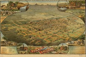
Aerial lithograph of Phoenix from 1885
Swilling had a series of canals built that followed those of the ancient Native American system. A small community formed that same year about 4 miles (6 km) east of the present city. It was first called Pumpkinville due to the large pumpkins that flourished in fields along the canals, then Swilling's Mill in his honor, though it was later renamed Helling Mill, Mill City, and finally, East Phoenix. Finally, the name "Phoenix" was suggested, as it describes a city born from the ruins of a former civilization.[6]
The first post office was established in 1868. With the number of residents growing (the 1870 U.S. census reported about a total Salt River Valley population of 240), a town site needed to be selected. On October 20, 1870, the residents held a meeting to decide where to locate it. A 320-acre (1.3 km²) plot of land was purchased in what is now the downtown business section.
On February 12, 1871, the territorial legislature created Maricopa County. The first election for county office was held in 1871. The first church opened in 1871, as did the first store. Public school had its first class on September 5, 1872, in the courtroom of the county building. By October 1873, a small school was completed on Center Street (now Central Avenue). A short time later, a telegraph office, 16 saloons, four dance halls, and two banks were open.
Incorporation
By 1881, Phoenix had outgrown its original townsite-commissioner form of government. The 11th Territorial Legislature passed the Phoenix Charter Bill, incorporating Phoenix and providing for a mayor-council government. The bill was signed by Governor John C. Fremont on February 25, 1881. Phoenix was incorporated with a population of approximately 2500, and on May 3, 1881, Phoenix held its first city election.
The coming of the railroad in the 1880s was the first of several important events that revolutionized the economy of Phoenix. Merchandise now flowed into the city by rail instead of wagon. Phoenix became a trade center, with its products reaching eastern and western markets.
Modern Phoenix (1900-present)
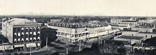
Central Avenue, Phoenix, Arizona, 1908
In 1902, President Theodore Roosevelt signed the National Reclamation Act allowing for dams to be built on western streams for reclamation purposes. Residents were quick to enhance this by organizing the Salt River Valley Water Users' Association to manage the water and power supply. The agency still exists as part of the Salt River Project. The Roosevelt Dam east of the valley was completed in 1911. Several new lakes were formed in the surrounding mountain ranges. In the Phoenix area, the river dried out, taking with it the large populations of migrating birds, beavers, and cottonwood trees.
In 1912, Phoenix became the capital of the newly formed state of Arizona. Phoenix was considered preferable as both territorial and state capital due to its more central location compared to Tucson or Prescott. It was initially smaller than Tucson but outgrew that city within the next few decades to become the state's largest. In 1913, Phoenix switched from mayor-council to council-manager, making it one of the first cities in the United States with this form of city government.

Phoenix in the early twentieth century.

The Phoenix skyline, 2001.
During World War II, Phoenix's economy shifted to that of a distribution center, rapidly turning into an embryonic industrial city with mass production of military supplies. Luke Field, Williams Field, and Falcon Field, coupled with the giant ground-training center at Hyder, west of Phoenix, brought thousands of new people into Phoenix. The Papago Park Prisoner of War Camp was established for internment of Japanese-Americans. Only a few of its former buildings remain today.
By 1950, over 100,000 people lived within the city and thousands more in surrounding communities. There were 148 miles (238 km) of paved streets and 163 miles (262 km) of unpaved streets.
Over the next several decades, the city and metropolitan area attracted more growth. Nightlife and civic events concentrated along Central Avenue. By the 1970s, however, there was rising crime and a decline in business within the downtown core.
Arizona Republic writer Don Bolles was murdered by a car bomb in 1976. It was believed that his investigative reporting on organized crime in Phoenix made him a target. Bolles' last words referred to Phoenix land and cattle magnate Kemper Marley, who was widely regarded to have ordered Bolles' murder, as well as John Harvey Adamson, who pleaded guilty to second-degree murder in 1977 in return for testimony against contractors Max Dunlap and James Robison. Dunlap was convicted of first degree murder in the case in 1990 and remains in prison, while Robison was acquitted but pleaded guilty to charges of soliciting violence against Adamson.
Street gangs and the drug trade had turned into public safety issues by the 1980s. Van Buren Street, east of downtown, became associated with prostitution. The city's crime rates in many categories have improved since that time but still exceed state and national averages.
Phoenix has maintained a massive growth streak in recent years, growing by 24.2 percent since 2000. This makes it the second-fastest-growing metropolitan area in the United States following only Las Vegas, whose population has grown by 29.2 percent since 2000.[7]
Government
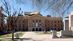
The Arizona State Capitol, which once housed the state legislature is now a museum.

Downtown Phoenix south of Jefferson Street
Being the capital of Arizona, Phoenix houses the state legislature. The city of Phoenix is served by a city council consisting of a mayor and eight city council members. The mayor is elected at large, to a four-year term. Phoenix City Council members are elected to four-year terms by voters in each of the eight separate districts that they represent. The mayor and city council members have equal voting power to adopt ordinances and set the policies that govern the city.
Phoenix operates under a council-manager form of government, with a strong city manager supervising all city departments and executing policies adopted by the council.
Economy
The early economy of Phoenix was primarily agricultural, dependent mainly on cotton and citrus farming. In the last two decades, the economy has diversified as swiftly as the population has grown. As the state capital of Arizona, many residents in the area are employed by the government. Arizona State University has also enhanced the area's population through education and its growing research capabilities. Numerous high-tech and telecommunications companies have also recently relocated to the area. Due to the warm climate in winter, Phoenix benefits greatly from seasonal tourism and recreation, and has a particularly vibrant golf industry.
Phoenix is currently home to seven major Fortune 1000 companies: waste management company Allied Waste, electronics corporation Avnet, Apollo Group (which operates the University of Phoenix), mining company Freeport-McMoRan (recently merged with Phoenix based Phelps Dodge), retailer PetSmart, energy supplier Pinnacle West and retailer CSK Auto. Honeywell's Aerospace division is headquartered in Phoenix, and the valley hosts many of their avionics and mechanical facilities. Intel has one of their largest sites here, employing about 10,000 employees and 3 chip manufacturing fabs, including the $3 billion state-of-the-art 300 mm and 45nm Fab 32. American Express hosts their financial transactions, customer information, and their entire website in Phoenix. The area is also home to US Airways Group, a Fortune 500 company located in Tempe also home to Insight Enterprises
(also listed on the Fortune 500). Phoenix is also home to the headquarters of U-HAUL International, a rental company and moving supply store, as well Best Western, a hotel chain, is also headquartered in the city.
In recent years many Internet companies have found a home in Phoenix. Internet companies like eBay, Google, AOL, GoDaddy.com, IPowerWeb, and Easynews all have major offices located in Phoenix.
The military has a significant presence in Phoenix with Luke Air Force Base, located in the western suburbs.
Transportation
- Air
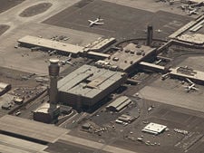
An aerial view of the new control tower at Phoenix Sky Harbor that began operations on January 17, 2007.
Phoenix is served by Sky Harbor International Airport, the ninth-busiest airport in the U.S. and 18th in the world[8] for passenger traffic, handling more than 41 million travelers in 2006.
- Public transportation
Public transportation throughout the metropolitan area is provided by Valley Metro, which operates a system of buses and a rideshare program. Only 3.38 percent of work commutes are made by public transit. Valley Metro began construction on a light rail project in March 2005, with a projected completion date of December 2008. Interest has also been expressed in Phoenix and several neighboring cities for the creation of a commuter rail system operating on existing railroad lines.
Phoenix is the largest city in the United States without intercity passenger rail service.
Phoenix is served by a growing network of freeways, many of which were initiated by a ½ cent general sales tax measure approved by voters in 1985. Before this network, Interstate 10 and Interstate 17 handled almost all freeway traffic in Phoenix, placing a large burden on surface arterial streets, leading to increased traffic congestion as the area grew in size.
Education
Public education in the Phoenix area is provided by over 30 school districts. The Phoenix Union High School District operates most of the public high schools in the city of Phoenix.
Arizona State University is the main institution of higher education in the area. It is currently one of the largest public universities in the United States, with a 2007 student enrollment of 64,394.
The University of Phoenix is also headquartered in the city. This is the nation's largest for-profit university with over 130,000 students at campuses throughout the United States (including Puerto Rico), Canada, Mexico, and the Netherlands, as well as online.
There are also ten community colleges and two skills centers throughout Maricopa County, providing adult education and job training.
Demographics and culture

The US Airways Center in downtown Phoenix is a sports and entertainment arena. It opened in 1992, and is the home of the Phoenix Suns of the National Basketball Association, the Phoenix Mercury of the Women's National Basketball Association, the Arizona Rattlers of the Arena Football League, and the Phoenix Roadrunners of the East Coast Hockey League.
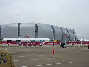
University of Phoenix Stadium on the game day of Super Bowl XLII on February 3, 2008.
According to the 2000 census, there were 1,321,045 people, 865,834 households, and 407,450 families residing in the city. The population density was 2,782 people per square mile (1,074/km²). There were 895,832 housing units at an average density of 1,044 per square mile (403/km²). The percentage of people living below the poverty line was 15.8 percent. By 2007 the estimated population had risen to over 1.5 million. The Phoenix Metropolitan Statistical Area (MSA) (officially known as the Phoenix-Mesa-Scottsdale MSA), is the 13th largest in the United States, with a total population of 4,039,182 as of the June 2006 update of the 2000 U.S. census.
As of 2000, the racial makeup of the Phoenix was 71.1 percent white, 34.1 percent Hispanic or Latino of any race, 5.1 percent African American, 2.0 percent Native American, 2.0 percent Asian, 0.13 percent Pacific Islander, 16.4 percent from other races, and 3.3 percent from two or more races. [9] Since the 2000 census, the non-Hispanic white population in Phoenix dropped below 50 percent.[10]
In 2000, the Phoenix metro area's religious composition was reported as 45 percent Catholic, 13 percent Mormon (concentrated heavily in the suburb of Mesa), and 5 percent Jewish. The remaining 37 percent are largely members of Protestant denominations, or are unaffiliated.
Phoenix and the surrounding area is home to a broad range of cultural activities including the performing arts, museums, and events. One music venue is the Phoenix Symphony Hall, where performances from groups such as Arizona Opera and Ballet Arizona often occur. Another is the Orpheum Theatre, which is home to the Phoenix Metropolitan Opera. Concerts also regularly make stops in the area. Several smaller theaters support regular independent musical and theater performances. The downtown Phoenix art scene has also developed significantly in the past decade.
One of the most well-known museums in the area is the Heard Museum just north of downtown. Some of the signature exhibits include a full Navajo hogan, historic Hopi kachina dolls, and an exhibit on the nineteen-century boarding school experiences of Native Americans. The Heard Museum attracts about 250,000 visitors a year.
Other notable museums include the Arizona Science Center, Fleischer Museum, Hall of Flame Firefighting Museum, Arizona Historical Society Museum, Phoenix Museum of History, the Phoenix Zoo, and the Pueblo Grande Museum and Cultural Park.
Phoenix has long been renowned for authentic Mexican food, thanks to both the large Hispanic population and proximity to Mexico. But the recent population boom has brought people from all over the nation and from other countries. International cuisines, such as Korean, Brazilian, and French, have become more common throughout the valley in recent years.
Phoenix is home to several professional sports franchises, including representatives of all four major professional sports leagues in the U.S. The first major franchise was the Phoenix Suns of the National Basketball Association (NBA), which started play in 1968. The Arizona Cardinals moved to Phoenix from St. Louis, Missouri, in 1988 and play in the NFL's National Football Conference – West Division. The Arizona Diamondbacks of Major League Baseball (National League West Division) began play as an expansion team in 1998. The team plays at Chase Field (downtown). In 2001, the Diamondbacks defeated the New York Yankees 4 games to 3 in the World Series, becoming not only the city's first professional sports franchise to win a national championship, but also the youngest expansion franchise in U.S. professional sports to ever do so. Additionally, due to the favorable climate, nine Major League Baseball teams conduct spring training in the metro area, as well as in nearby Tucson.
Notes
- ↑ City of Phoenix. November 10, 2008. Community Trends and Profile Retrieved November 19, 2008.
- ↑ US Census Bureau. June 28, 2007. Population Estimates for the 25 Largest U.S. Cities based on July 1, 2006 Population Estimates.
- ↑ Steve Eastwood. January 2006. Brown Air in the Valley About.com.
- ↑ National Oceanic and Atmospheric Administration. Facts about 100 Degree Temperatures at Phoenix Retrieved November 19, 2008.
- ↑ National Climatic Data Center. June 4, 2004. Mean Number of Days With Minimum Temperature 32 °F (0 °C) or Less Retrieved November 19, 2008.
- ↑ City of Phoenix. Out of the Ashes, Phoenix is Born. Retrieved November 19, 2008.
- ↑ Matt Woolsey. In Pictures: America's Fastest-Growing Cities Forbes. Retrieved November 19, 2008.
- ↑ Airports Council International. Passenger Traffic 2006 FINAL Retrieved November 19, 2008.
- ↑ FedStats. August 7, 2008. Phoenix (city), Arizona Retrieved November 19, 2008.
- ↑ Anushka Asthana. August 21, 2006. Changing Face of Western Cities Washington Post. Retrieved November 19, 2008.
References
ISBN links support NWE through referral fees
- Abbott, David R. 2000. Ceramics and community organization among the Hohokam. Tucson: University of Arizona Press. ISBN 9780816519361
- Chavez, Cesar, Richard J. Jensen, and John C. Hammerback. 2002. The words of César Chávez. College Station: Texas A & M University Press. ISBN 9781585449620
- Logan, Michael F. 2006. Desert cities: the environmental history of Phoenix and Tucson. History of the urban environment. Pittsburgh, Pa: University of Pittsburgh Press. ISBN 9780822942948
- Reynolds, Kate. Insiders' Guide to Phoenix, 6th ed. (Insiders' Guide Series) 2008, ISBN 0762748680.
External links
All links retrieved November 23, 2022.
Credits
New World Encyclopedia writers and editors rewrote and completed the Wikipedia article
in accordance with New World Encyclopedia standards. This article abides by terms of the Creative Commons CC-by-sa 3.0 License (CC-by-sa), which may be used and disseminated with proper attribution. Credit is due under the terms of this license that can reference both the New World Encyclopedia contributors and the selfless volunteer contributors of the Wikimedia Foundation. To cite this article click here for a list of acceptable citing formats.The history of earlier contributions by wikipedians is accessible to researchers here:
The history of this article since it was imported to New World Encyclopedia:
Note: Some restrictions may apply to use of individual images which are separately licensed.


