Difference between revisions of "Bamako" - New World Encyclopedia
Mary Anglin (talk | contribs) m (→Geography) |
Mary Anglin (talk | contribs) |
||
| Line 138: | Line 138: | ||
[[Image:Sotrumas in Bamako - 12th February 2005.jpg|right|thumb|250px|Sotramas in Bamako]] | [[Image:Sotrumas in Bamako - 12th February 2005.jpg|right|thumb|250px|Sotramas in Bamako]] | ||
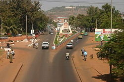
[[Image:Bamako Avenue Avenue Al Qoods.jpg|thumb|right|250px|Avenue Al Qoods in central Bamako]] | [[Image:Bamako Avenue Avenue Al Qoods.jpg|thumb|right|250px|Avenue Al Qoods in central Bamako]] | ||
| − | The fertile lands of the Bamako region have been inhabited for more than 150,000 years. | + | The fertile lands of the Bamako region have been inhabited for more than 150,000 years. Early kingdoms grew rich through trading [[gold]], [[ivory]], [[kola nut]]s, and [[salt]] using trade routes crossing the [[Sahara Desert|Sahara]] into [[northern Africa]], and eventually to [[Europe]]. |
| − | Early kingdoms grew rich trading gold, ivory, kola | ||
| − | By the 11th century the [[Empire of Ghana]] (750-1076) became the first dominant kingdom in the area, and the city of Timbuktu became a commercial | + | By the 11th century the [[Empire of Ghana]] (750-1076) became the first dominant kingdom in the area, and the city of [[Timbuktu]] became a commercial center with over 100,000 inhabitants, and a center for [[Islam]]ic learning. Two universities were built as well as several mosques. |
| − | |||
| − | The [[Songhai Empire]] (1464-1591) had a professional army, a civil service and even subsidized doctors and religious leaders. In the 16th century Berber invaders from [[Morocco]] destroyed what remained of the kingdoms in Mali and trader-sailors began to undermine trans-Saharan trade. | + | The [[Mali Empire]] (1235-1600) , which included modern day [[Mali]], [[Senegal]], [[Gambia]], [[Guinea]], and [[Mauritania]], became rich trading [[cotton]] and salt. |
| + | |||
| + | The [[Songhai Empire]] (1464-1591) had a professional army, a civil service and even subsidized doctors and religious leaders. In the 16th century [[Berber]] invaders from [[Morocco]] destroyed what remained of the kingdoms in Mali and trader-sailors began to undermine trans-Saharan trade. | ||
Bamako was founded in the 17th century by [[Seribadian Niaré]] and [[Soumba Coulibaly]], or [[Bamba Sanogo]], before its chiefdom passed to [[Diaoussadian Niaré]]. The city was an important [[market town]]. | Bamako was founded in the 17th century by [[Seribadian Niaré]] and [[Soumba Coulibaly]], or [[Bamba Sanogo]], before its chiefdom passed to [[Diaoussadian Niaré]]. The city was an important [[market town]]. | ||
| − | In 1883, the region was occupied by [[France|French]] troops, at which time it was a settlement of a few hundred inhabitants, grouped in villages. The cultivation of cotton and rice was encouraged through large irrigation projects. | + | In 1883, the region was occupied by [[France|French]] troops, at which time it was a settlement of a few hundred inhabitants, grouped in villages. The cultivation of cotton and [[rice]] was encouraged through large irrigation projects. |
| − | In 1908, Bamako became the capital of the [[French Sudan]], four years after the Kayes–Bamako segment of the Dakar–Niger Railway, which connected the Niger River with the port of Dakar, was opened. Its population grew to approximately 160,000 in 1960. | + | In 1908, Bamako became the capital of the [[French Sudan]], four years after the Kayes–Bamako segment of the Dakar–Niger Railway, which connected the Niger River with the port of [[Dakar]], was opened. Its population grew to approximately 160,000 in 1960. |
In early 1959, the union of Mali and [[Senegal]] became the Mali Federation, which gained independence from [[France]] on June 20, 1960. Senegal withdrew from the Mali Federation after a few months. The Republic of Mali, under [[Modibo Keïta]], withdrew from the French Community on September 22, 1960. | In early 1959, the union of Mali and [[Senegal]] became the Mali Federation, which gained independence from [[France]] on June 20, 1960. Senegal withdrew from the Mali Federation after a few months. The Republic of Mali, under [[Modibo Keïta]], withdrew from the French Community on September 22, 1960. | ||
| Line 156: | Line 156: | ||
Keïta was the victim of a coup in 1968, bringing to power young officers belonging to the Military Committee for National Liberation. When the committee broke up, a single party emerged and ruled until 1991. | Keïta was the victim of a coup in 1968, bringing to power young officers belonging to the Military Committee for National Liberation. When the committee broke up, a single party emerged and ruled until 1991. | ||
| − | Public opposition to the single-party regime led to a coup in 1991, a transitional government, and a new constitution. In 1992, Alpha Oumar Konaré won Mali's first democratic, multiparty presidential election. Upon his re-election in 1997, Konaré pushed through political and economic reforms and fought corruption. In 2002, he was succeeded in democratic elections by Amadou Toumani Touré, a retired general who had been a leader of the 1991 democratic uprising. | + | Public opposition to the single-party regime led to a coup in 1991, a transitional government, and a new constitution. In 1992, Alpha Oumar Konaré won Mali's first democratic, multiparty presidential election. Upon his re-election in 1997, Konaré pushed through political and economic reforms and fought corruption. In 2002, he was succeeded in democratic elections by [[Amadou Toumani Touré]], a retired general who had been a leader of the 1991 democratic uprising. |
==Government== | ==Government== | ||
Revision as of 04:33, 25 July 2008
| Bamako, Mali | |
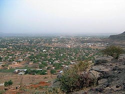
| View of Bamako | |
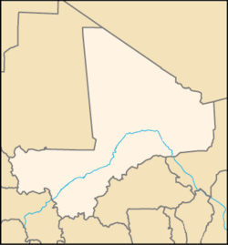
| Bamako within Mali | |
| Coordinates: 12°39′N 8°0′W | |
|---|---|
| Country | Mali |
| District | Bamako |
| Population (2006) | |
| - Total | 1,690,471 |
Bamako is the capital and largest city of Mali, which is among the poorest countries in the world. Estimated in 2006 to be the fastest growing city in Africa (and sixth fastest in the world), Bamako is the seventh largest West African urban center after Lagos, Abidjan, Kano, Ibadan, Dakar and Accra.
Inhabited for more than 150,000 years, the area that is now Bamako has been part of the great west African empires, a French colony until independence in 1960, and it went through 24 years of single-party socialist rule. Bamako is center of the distinctive griot music, which has attracted the interest of high-profile Western performers.
Geography
The name Bamako comes from the Bambara word meaning "crocodile's back".
Bamako, is a hot, dusty city that spans both sides of the wide and murky Niger River, near rapids that divide the Upper and Middle Niger Valleys, in the southwestern part of Mali. Bamako, which feels like an overgrown village, with a handful of high-rises, is relatively flat, except to the north where there is an escarpment, remains of an extinct volcano. Goats graze along roadsides.
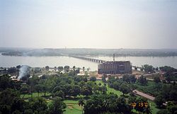
Niger River tributaries defined the development of the city which is on a flood plain, so much of the land bordering the river cannot be used for construction. The Presidential Palace and main hospital are located there.
Bamako is hot and dry from February to June, reaching 101°F in April; rainy, humid, and mild from June to November (between 71°F to 88°F); and cool and dry from November to February (between 63°F to 90°F). Precipitation reaches 14 inches (350mm) in August.
The Niger River is navigable 225 miles (360km) south, to Kouroussa, Guinea, during the wet season, while a canal around the Sotuba Rapids has enabled shipping to Gao 869 miles (1398km) to the north.
Originally, the city developed on the northern side of the river, but as it grew, bridges were developed to connect the north with the south. There is an older submersible bridge between the eastern neighborhoods of Sotuba and Misabugu inherited from colonial times. It is typically under water from July to January.
The traditional commercial center of Bamako is to the north of the river, and contained within a triangle bounded by Avenue du Fleuve, Rue Baba Diarra, and Boulevard du Peuple. This area contains the Marché Rose and Street Market.
The downtown area is highly congested, polluted, and expensive, and urbanization is sprawling at a rapid pace within a radius of 19 miles (30km). The largest urbanized area lies on the southern bank of the Niger River. A modern Central Business District is developing immediately west of the downtown area, following a geometric layout, the legacy of the old airport runways and taxiways. A large Administrative City is being developed near the King Fadh Bridge, purportedly to host most state departments' (ministries) and administrative services.
History
The fertile lands of the Bamako region have been inhabited for more than 150,000 years. Early kingdoms grew rich through trading gold, ivory, kola nuts, and salt using trade routes crossing the Sahara into northern Africa, and eventually to Europe.
By the 11th century the Empire of Ghana (750-1076) became the first dominant kingdom in the area, and the city of Timbuktu became a commercial center with over 100,000 inhabitants, and a center for Islamic learning. Two universities were built as well as several mosques.
The Mali Empire (1235-1600) , which included modern day Mali, Senegal, Gambia, Guinea, and Mauritania, became rich trading cotton and salt.
The Songhai Empire (1464-1591) had a professional army, a civil service and even subsidized doctors and religious leaders. In the 16th century Berber invaders from Morocco destroyed what remained of the kingdoms in Mali and trader-sailors began to undermine trans-Saharan trade.
Bamako was founded in the 17th century by Seribadian Niaré and Soumba Coulibaly, or Bamba Sanogo, before its chiefdom passed to Diaoussadian Niaré. The city was an important market town.
In 1883, the region was occupied by French troops, at which time it was a settlement of a few hundred inhabitants, grouped in villages. The cultivation of cotton and rice was encouraged through large irrigation projects.
In 1908, Bamako became the capital of the French Sudan, four years after the Kayes–Bamako segment of the Dakar–Niger Railway, which connected the Niger River with the port of Dakar, was opened. Its population grew to approximately 160,000 in 1960.
In early 1959, the union of Mali and Senegal became the Mali Federation, which gained independence from France on June 20, 1960. Senegal withdrew from the Mali Federation after a few months. The Republic of Mali, under Modibo Keïta, withdrew from the French Community on September 22, 1960.
Keïta was the victim of a coup in 1968, bringing to power young officers belonging to the Military Committee for National Liberation. When the committee broke up, a single party emerged and ruled until 1991.
Public opposition to the single-party regime led to a coup in 1991, a transitional government, and a new constitution. In 1992, Alpha Oumar Konaré won Mali's first democratic, multiparty presidential election. Upon his re-election in 1997, Konaré pushed through political and economic reforms and fought corruption. In 2002, he was succeeded in democratic elections by Amadou Toumani Touré, a retired general who had been a leader of the 1991 democratic uprising.
Government
Mali is a republic in which a president, who is elected for a five-year term, appoints the prime minister and chairs the Council of Ministers, which adopts proposals for laws submitted to the National Assembly for approval. The National Assembly is the sole legislative arm and consists of 147 members. Mali is divided into eight administrative regions, which are made up of districts. These districts are composed of communes, which contain villages. Since decentralization plans began, a total of 702 local municipal councils have been formed. These are headed by elected mayors.
Mali is a source, transit, and destination country for women and children trafficked for the purposes of forced labor and sexual exploitation. Women and girls are trafficked for domestic servitude and sexual exploitation, and boys for work in rice fields or gold mines and for begging. Although the majority are sold within the country, the victims are also sent to neighboring nations (Libya) and Europe.
Economy
Mali is among the poorest countries in the world, with 65 percent of its land area desert or semi-desert and with a highly unequal distribution of income. About 10 percent of the population is nomadic and some 80 percent of the labor force is engaged in farming and fishing. Industrial activity is concentrated on processing farm commodities. Mali is heavily dependent on foreign aid and vulnerable to fluctuations in world prices for cotton, its main export, along with gold.
Bamako is the nation's administrative center, with a river port located in nearby Koulikoro, and a major regional trade and conference center. Manufactures at Bamako include textiles, processed meat and metal goods. There is commercial fishing on the Niger River.
Per capita GDP was $US1000 in 2007, with a rank of 163 on the international Monetary Fund list of 179 nations.
River transport is used extensively. Cement and petroleum products are shipped down the river from the city. Rice and peanuts are moved upstream to be freighted on the Dakar-Niger Railway, to Koulikoro in eastern Mali, and Dakar in Senegal. Bamako Senou International Airport, Mali's main airport, is located some 15km south of downtown Bamako. Passenger traffic reached the 516,000 mark in 2005.
Demographics
Bamako's population was 1,690,471 in 2006. Rural migration from drought-stricken areas tripled the size of the city from 1960 to 1970. Bamako was listed, in 2006, as the sixth fastest growing urban area on a list of 100 cities, growing at a rate of 4.45 percent each year.
The ethic groups of Mali comprise Mande 50 percent, (Bambara, Malinke, Soninke), Peul 17 percent, Voltaic 12 percent, Songhai six percent, Tuareg and Moor 10 percent, and others five percent
While French is the official language, 80 percent speak Bambara, which belongs to a group of closely-related languages called Manding, while numerous other African languages are spoken.
Ninety percent of the population are Muslim, Christians make up one percent, while the remaining nine percent follow indigenous beliefs.
Bamako is the location of several research institutes and four colleges
Society and culture
Bamako is the center the distinctive griot music. The soulful singer Salif Keita and the late singer-guitarist Ali Farka Touré sparked a boom in Malian music in the 1990s. The country's griot music, with haunting melodies based on the pentatonic scale, and its themes of shattered romance, has similarities with American blues music. Western artists including Robert Plant, Ry Cooder, Bonnie Raitt, and the late John Lee Hooker have visited Bamako to jam and record with the local musicians.
Notable landmarks in Bamako include the National Library of Mali, Tour BCEAO, Bamako Grand Mosque, Cathedral of Bamako and the King Fahd Bridge.
Attractions include the Mali National Museum, the Muso Kunda Museum, the Bamako Regional Museum, Bamako Zoo, the Bamako Botanical Gardens and the Point G hill, containing caves with rock paintings. Bamako has hosted the biannual photography festival African Photography Encounters since 1994.
In 1988, Bamako was the location of a WHO conference known as the Bamako Initiative that helped reshape health policy of Sub-Saharan Africa.
The annual Budapest-Bamako rally has the endpoint in Bamako, with the Dakar Rally often passing through Bamako.
ReferencesISBN links support NWE through referral fees
- City Mayors Statistics. World's fastest growing cities and urban areas from 2006 to 2020 Retrieved July 23, 2008.
- Dulucq, Sophie. 2005. Bamako. Encyclopedia of African History. 122-123. OCLC 61749600
- Perinbam, B. Marie. 1994. Identity ritual and the state in the Bamako Kafu and Mande-hinterland. [S.l.]: African Studies Association. OCLC 122267480
External links
- Siren song of Mali The New York Times, retrieved July 23, 2008.
- Sampling the sounds of Mali without leaving home The New York Times, retrieved July 23, 2008.
- Drumming Videos Shot in Bamako Retrieved July 23, 2008.
- Budapest-Bamako rally Retrieved July 23, 2008.
- Pictures of Bamako Retrieved July 23, 2008.
Credits
New World Encyclopedia writers and editors rewrote and completed the Wikipedia article in accordance with New World Encyclopedia standards. This article abides by terms of the Creative Commons CC-by-sa 3.0 License (CC-by-sa), which may be used and disseminated with proper attribution. Credit is due under the terms of this license that can reference both the New World Encyclopedia contributors and the selfless volunteer contributors of the Wikimedia Foundation. To cite this article click here for a list of acceptable citing formats.The history of earlier contributions by wikipedians is accessible to researchers here:
The history of this article since it was imported to New World Encyclopedia:
Note: Some restrictions may apply to use of individual images which are separately licensed.
