Difference between revisions of "Petroglyph" - New World Encyclopedia
Nick Perez (talk | contribs) |
Nick Perez (talk | contribs) (→Africa) |
||
| Line 34: | Line 34: | ||
===Africa=== | ===Africa=== | ||
| − | + | [[Image:Lion Twyfelfontein Namibia.JPG|thumb|250px|Lion Petroglyph, Twyfelfontein, Namibia]] | |
There are many famous sights of petroglyph works in [[Africa]]. [[Tassili n'Ajjer]] in [[Algeria]] is noted for its [[prehistoric]] [[rock painting]]s and other ancient [[archaeology|archaeological]] sites, dating from [[neolithic]] times when the local climate was much moister, with [[Savanna|savannah]] rather than desert. The art depicts herds of cattle, large wild animals including crocodiles, and human activities such as hunting and dancing. The art has strong stylistic links to the pre-Nguni [[Art of South Africa]] and the region, executed in caves by the San Peoples before the year 1200 C.E. | There are many famous sights of petroglyph works in [[Africa]]. [[Tassili n'Ajjer]] in [[Algeria]] is noted for its [[prehistoric]] [[rock painting]]s and other ancient [[archaeology|archaeological]] sites, dating from [[neolithic]] times when the local climate was much moister, with [[Savanna|savannah]] rather than desert. The art depicts herds of cattle, large wild animals including crocodiles, and human activities such as hunting and dancing. The art has strong stylistic links to the pre-Nguni [[Art of South Africa]] and the region, executed in caves by the San Peoples before the year 1200 C.E. | ||
| Line 76: | Line 76: | ||
Other important sites include [[Chumysh (river)|Chumysh River]] basin, in Khaszikstan, the [[Tamgaly]] on the [[Ili River]], a [[World Heritage Site]], the [[Yin Mountains]] in [[Inner Mongolia]], the [[Northern Areas#Rock art and petroglyphs|Rock art and petroglyphs in Northern Areas]] in Pakistan, and the [[Angono Petroglyphs]] of [[Rizal]] in the [[Phillipines]]. | Other important sites include [[Chumysh (river)|Chumysh River]] basin, in Khaszikstan, the [[Tamgaly]] on the [[Ili River]], a [[World Heritage Site]], the [[Yin Mountains]] in [[Inner Mongolia]], the [[Northern Areas#Rock art and petroglyphs|Rock art and petroglyphs in Northern Areas]] in Pakistan, and the [[Angono Petroglyphs]] of [[Rizal]] in the [[Phillipines]]. | ||
| − | |||
| − | |||
| − | |||
===South America=== | ===South America=== | ||
| − | + | [[Image:PetroglyphAzapa1.jpg|thumb|left|175px|A petroglyph from the Azapa valley, exhibited in front of the museum in San Miguel de Azapa, 12 km east of Arica, Chile]] | |
There are two famous sites of petroglyphs in [[South America]]. [[Cumbe Mayo]] in [[Peru]] is the site of ruins of a Pre-Columbian aqueduct stretching approximately five miles in length. There are a number of [[petroglyphs]] on the aqueduct and surrounding caverns. | There are two famous sites of petroglyphs in [[South America]]. [[Cumbe Mayo]] in [[Peru]] is the site of ruins of a Pre-Columbian aqueduct stretching approximately five miles in length. There are a number of [[petroglyphs]] on the aqueduct and surrounding caverns. | ||
| Line 88: | Line 85: | ||
===North America=== | ===North America=== | ||
| − | North America has the more sites of petroglyphs than any other continent. A large cluster is located in the Southwestern [[United States]], and are protected by National Park boundaries, such as [[Arches National Park]] and [[Capitol Reef National Park]] of [[Utah]], [[Death Valley National Park]], [[Lava Beds National Monument]], [[Tule Lake, California|Tule Lake]], [[Maturango Canyon]], and [[Coso Range, Northern Mojave]] in [[California]]. There are also | + | North America has the more sites of petroglyphs than any other continent. A large cluster is located in the Southwestern [[United States]], and are protected by National Park boundaries, such as [[Arches National Park]] and [[Capitol Reef National Park]] of [[Utah]], [[Death Valley National Park]], [[Lava Beds National Monument]], [[Tule Lake, California|Tule Lake]], [[Maturango Canyon]], and [[Coso Range, Northern Mojave]] in [[California]]. There are also sites in [[Arkansa]], [[Washington]], [[Michigan]] and [[Ohio]]. |
| − | + | [[Image:Petroglyphs in Bryce Canyon.jpg|thumb|175px|Petroglyphs in Bryce Canyon National Park]] | |
| − | |||
[[Jeffers Petroglyphs]], [[Minnesota]] - The '''Jeffers Petroglyphs''' site is an outcrop of rock in southwestern [[Minnesota]] with pre-contact [[Native Americans in the United States|Native American]] [[petroglyph]]s. The petroglyphs are pecked into rock of the Red Rock Ridge, a {{convert|23|mi|km|0|sing=on}}-long [[quartzite|Sioux quartzite]] outcrop that extends from [[Watonwan County, Minnesota]] to [[Brown County, Minnesota]]. The exposed surface is approximately {{convert|150|ft|m|-1}} by {{convert|650|ft|m|-1}} and surrounded by virgin prairie. Several old wagon trail ruts traverse the site, one of which is believed to be the old stage coach route from [[New Ulm, Minnesota]] to [[Sioux Falls, South Dakota]].<ref name='Roefer'>Roefer</ref> | [[Jeffers Petroglyphs]], [[Minnesota]] - The '''Jeffers Petroglyphs''' site is an outcrop of rock in southwestern [[Minnesota]] with pre-contact [[Native Americans in the United States|Native American]] [[petroglyph]]s. The petroglyphs are pecked into rock of the Red Rock Ridge, a {{convert|23|mi|km|0|sing=on}}-long [[quartzite|Sioux quartzite]] outcrop that extends from [[Watonwan County, Minnesota]] to [[Brown County, Minnesota]]. The exposed surface is approximately {{convert|150|ft|m|-1}} by {{convert|650|ft|m|-1}} and surrounded by virgin prairie. Several old wagon trail ruts traverse the site, one of which is believed to be the old stage coach route from [[New Ulm, Minnesota]] to [[Sioux Falls, South Dakota]].<ref name='Roefer'>Roefer</ref> | ||
| − | + | [[Petroglyph National Monument]] - '''[[Petroglyph]] National Monument''' stretches 17 miles (27 km) along [[Albuquerque, New Mexico]]'s West Mesa, a [[volcanic]] [[basalt]] [[escarpment]] that dominates the city’s western horizon. Authorized [[June 27]], [[1990]], the 7,236 [[acre]] (29.28 km²) monument is cooperatively managed by the [[National Park Service]] and the City of Albuquerque. Petroglyph National Monument protects a variety of cultural and natural resources including five [[volcanic cones]], hundreds of archeological sites and an estimated 25,000 images carved by native peoples and early Spanish settlers. Many of the images are recognizable as animals, people, [[Livestock branding|brands]] and crosses; others are more complex. Their meaning was, possibly, understood only by the carver. These images are the cultural heritage of a people who have long since moved into other areas and moved on through history. The monument protects them for visitors to see and appreciate for generations to come. | |
| − | + | [[Image:Pictograph tds.jpg|thumb|left|175px|Native American Pictograph near Saint George, Utah USA]] | |
| − | |||
| − | |||
| − | |||
| − | |||
There are over 21,000 [[petroglyph]]s at the '''Three Rivers Petroglyph Site''' at Three Rivers, [[New Mexico]]<ref> | There are over 21,000 [[petroglyph]]s at the '''Three Rivers Petroglyph Site''' at Three Rivers, [[New Mexico]]<ref> | ||
[http://www.southernnewmexico.com/Articles/Southeast/Otero/ThreeRiversPetroglyphssit.html ''Three Rivers Petroglyphs Site — 21,000 Carvings''] Accessed May 27, 2007. | [http://www.southernnewmexico.com/Articles/Southeast/Otero/ThreeRiversPetroglyphssit.html ''Three Rivers Petroglyphs Site — 21,000 Carvings''] Accessed May 27, 2007. | ||
| Line 108: | Line 100: | ||
</ref> | </ref> | ||
| + | The exact age of the petroglyphs is not known, but some [[atlatl]] symbols at Jeffers are a close match with similar symbols at [[Indian Knoll]] in [[Kentucky]], which have been dated to 3000 B.C.E. These are probably the earliest petroglyphs at the site and indicate that the site was first visited during the [[Archaic period#Late_Archaic_period_.283000_BC_to_1000_BC.29|Late Archaic Period]]. Another clue to the age comes from the projectile point carvings, which show a projectile point design used by hunters in the Late Archaic Period. Other carvings, such as [[thunderbird (mythology)|thunderbirds]], dragonflies, turtles, and [[shaman]]s, are symbolic of later tribes such as the [[Otoe tribe]], [[Sioux]], and [[Iowa tribe]]. These are believed to date between 900 C.E. and 1750 C.E. | ||
| − | + | There are several sites in [[Canada]], in [[British Columbia]], [[Ontario]] and [[Nova Scotia]]. [[Petroglyphs Provincial Park]], north of [[Peterborough, Ontario|Peterborough]], [[Ontario]] - '''Petroglyphs Provincial Park''' is situated northeast of [[Peterborough, Ontario|Peterborough]], [[Ontario]], [[Canada]]. It has the largest collection of ancient [[First Nations]] [[petroglyph]]s (rock carvings) in Ontario. The carvings were created in the [[pre-Columbian]] era and represents aspects of First Nations mysticism, including [[shaman]]s, [[animal|animals]], and the [[Great Spirit]]. The sacred stone is generally believed to have been carved by the [[Algonquin|Algonkian people]] between [[10th century|900]] and [[15th century|1400 C.E.]]. Today, the First Nations people of Ontario call the carvings Kinomagewapkong, meaning "the rocks that teach" or "the Teaching Rocks". | |
| − | |||
| − | |||
| − | |||
| − | |||
| − | |||
| − | [ | ||
| − | |||
| − | |||
| − | |||
| − | |||
| − | |||
| − | |||
| − | |||
| − | The | ||
| − | + | There are also petroglyph sites at Mina, [[Nuevo Leon]] in [[Mexico]]. | |
| − | |||
| − | |||
| − | |||
| − | |||
| − | |||
| − | |||
| − | |||
| − | |||
| − | |||
| − | |||
| − | |||
| − | |||
| − | |||
| − | |||
| − | |||
===Europe=== | ===Europe=== | ||
| Line 190: | Line 154: | ||
Image:Petroglifo_bentayga.jpg|Petroglyph in Roque Bentayga, Gran Canaria (Canary Islands). | Image:Petroglifo_bentayga.jpg|Petroglyph in Roque Bentayga, Gran Canaria (Canary Islands). | ||
image:Petroglyphs on a Bishop Tuff tableland-750px.jpg|Petroglyphs on a Bishop Tuff tableland, eastern California, USA | image:Petroglyphs on a Bishop Tuff tableland-750px.jpg|Petroglyphs on a Bishop Tuff tableland, eastern California, USA | ||
| − | |||
| − | |||
Image:Ute Petroglyphs in Arches National Park.jpg|Arches National Park | Image:Ute Petroglyphs in Arches National Park.jpg|Arches National Park | ||
Image:Petroglyphs.jpg|Peterborough, Ontario, Canada | Image:Petroglyphs.jpg|Peterborough, Ontario, Canada | ||
Revision as of 14:09, 13 December 2007

_Petroglyphs_Wadi_Methkandoush_Luca_Galuzzi_2007.jpg)
Petroglyphs are images created by removing part of a rock surfaces by incising, pecking, carving, and abrading. Petroglyphs are found world-wide, and are often (but not always) associated with prehistoric peoples.They are one of the three different techniques used in Rock art, the prehistoric precursors to art. The meaning of these works is still unclear, but much conjecture and speculation has been produced in academic circles.
The word comes from the Greek words petros meaning "stone" and glyphein meaning "to carve" (it was originally coined in French as pétroglyphe).[1]
History

The oldest petroglyphs are dated to approximately the Neolithic and late Upper Paleolithic boundary, about 10,000 to 12,000 years ago, if not earlier (Kamyana Mohyla).[2] Around 7,000 to 9,000 years ago, other precursors of writing systems, such as pictographs and ideograms, began to appear. Petroglyphs were still common though, and some cultures continued using them much longer, even until contact with Western culture was made in the 20th century. Petroglyphs have been found in all parts of the globe except Antarctica with highest concentrations in parts of Africa, Scandinavia, Siberia, southwestern North America and Australia.
Technique
Petroglyphs are from removing rock in such ways as scratching, abrading, pecking, carving, drilling, incising and sculpting. Locations of choice are rock facets coated with patina, a dark mineral accumulation on rock surfaces. Petroglyphs remove the patina, exposing the contrasting lighter rock interior. Instances of negative images, produced by removing the patina surrounding the intended figure, are also known. Sometimes petroglyphs are painted or accentuated by polishing. The degree of repatination indicates relative dating. Some of the most ancient petroglyphs are the same color as the surrounding rock.
Interpretation

There are many theories to explain their purpose, depending on their location, age, and the type of image. Some petroglyphs are thought to be astronomical markers, maps, and other forms of symbolic communication, including a form of "pre-writing." They might also have been a by-product of other rituals: sites in India, for example, have been identified as musical instruments or "rock gongs." [3]
Some petroglyph images probably had deep cultural and religious significance for the societies that created them; in many cases this significance remains for their descendants. Many petroglyphs are thought to represent some kind of not-yet-fully understood symbolic or ritual language. Later glyphs from the Nordic Bronze Age in Scandinavia seem to refer to some form of territorial boundary between tribes, in addition to possible religious meanings. It also appears that local or regional dialects from similar or neighboring peoples exist. The Siberian inscriptions almost look like some early form of runes, although there is not thought to be any relationship between them. They are not yet well understood.
Some researchers have noticed the resemblance of different styles of petroglyphs across different continents; while it is expected that all people would be inspired by their surroundings, it is harder to explain the common styles. This could be mere coincidence, an indication that certain groups of people migrated widely from some initial common area, or indication of a common origin.[4] Other theories suggest that petroglyphs were made by shamans in an altered state of consciousness[5], perhaps induced by the use of natural hallucinogens. Many of the geometric patterns (known as form constants) which recur in petroglyphs and cave paintings have been shown to be "hard-wired" into the human brain; they frequently occur in visual disturbances and hallucinations brought on by drugs, migraine and other stimuli.
List of petroglyph sites
Africa

There are many famous sights of petroglyph works in Africa. Tassili n'Ajjer in Algeria is noted for its prehistoric rock paintings and other ancient archaeological sites, dating from neolithic times when the local climate was much moister, with savannah rather than desert. The art depicts herds of cattle, large wild animals including crocodiles, and human activities such as hunting and dancing. The art has strong stylistic links to the pre-Nguni Art of South Africa and the region, executed in caves by the San Peoples before the year 1200 C.E.
Akakus, Libya was inscribed as a UNESCO World Heritage Site in 1985 because of the importance of its rock paintings and carvings. The art dates from 12,000 B.C.E. to 100 C.E. and reflect cultural and natural changes in the area.[6] There are paintings and carvings of animals such as giraffes, elephants, ostriches and camels, but also of men and horses. Men are depicted in various daily life situations, for example while making music and dancing.
The ancient city of Wadi Hammamat in Qift, Egypt has many carvings and inscriptions dating from before the earliest Egyptian Dynasties to the modern era, including the only painted petroglyph known from the Eastern Desert and drawings of Egyptian reed boats dated to 4000 B.C.E.
Other important sites in Africa include Bidzar in Cameroon, Bambari, Lengo and Bangassou in the south of the Central African Republic; Bwale in the west, Niola Doa in Chad, the Niari River valley in the Congo, Ogooue River Valley in Gabon, Jebel Uweinat in Libya, the Draa River valley in Morocco, the Twyfelfontein in Namibia, and life-size giraffe carvings on Dabous Rock, Air Mountains, in Niger.
Australia

Murujuga, in Western Australia is a unique ecological and archaeological area since it contains the world's largest and most important collection of petroglyphs – ancient Aboriginal rock carvings some claim to date back as far as the last ice age. The collection of standing stones is the largest in Australia. The rock art numbers over a million petroglyphs and contains many images of the now extinct Thylacine (Tasmanian Tiger).
The Sydney Rock Engravings, consist of carefully drawn images of people, animals, or symbols, in the sandstone around Sydney, New South Wales, Australia. Many thousands of such engravings are known to exist in the Sydney region, although the locations of most are not publicized to prevent damage by vandalism, and to retain their sanctity, as they are still regarded as sacred sites by Indigenous Australians. They are comparable with the petroglyphs of Native Americans and the Rock Art found elsewhere in Australia, and yet have their own distinctive style which is quite unlike Rock Art found anywhere else in Australia.
There is also a famous petroglyph site at Arnhem Land / Kakadu National Park, in Northern Australia.
Asia

The diversity of Asia's geography and culture is mirrored in its quantity of petroglyphs. Hong Kong along has eight significant sites: Tung Lung Island, Kau Sai Chau, Po Toi Island, Cheung Chau, Shek Pik on Lantau Island, Wong Chuk Hang and Big Wave Bay on Hong Kong Island, Lung Ha Wan in Sai Kung
The Edakkal Caves Cavesin Wayanad, Kerala, in India date back to about 4000 B.C.E. These are not technically caves by rather a cleft or rift approximately 96 feet by 22 feet, a 30 foot deep fissure caused by a piece of rock splitting away from the main body. On one side of the cleft a rock weighing several tons has fallen over the fissure forming a roof. The carvings are of human and animal figures, as well as of tools used by humans and symbols, suggesting they were created by a highly civilised prehistoric people.[7] The petroglyphs inside the cave are of at least three distinct types. The oldest may date back over 5000 years ago. Evidence indicates that the Edakkal caves had been inhabited at several different times in history.[8]
The Bangudae Petroglyphs, in Korea are located in Daegok-ri, Ulsan, South Korea. This site of substantial engraved rock art was rediscovered in 1971 and was designated as the 285th National Treasure of South Korea on June 23, 1995. The petroglyphs sit in an isolated forested area almost completely enclosed by steep mountains adjacent to the Daegok-cheon River, a tributary of the Taehwa River. There are three major panels in an area measuring 3 m in height and 10 m in length. A number of panels with similar rock-art motifs has been found nearby at the Cheonjeon-ni site.
It is commonly thought that the petroglyphs (Kr. amgakhwa or bawi geurim, 바위그림) at this site depict the physical embodiment of the hopes and wishes of prehistoric people. The petroglyphs were made to wish for a successful hunt or an abundance of prey. Rock art also serves to facilitate or symbolize religious rites, mythological or historical narratives, territorial markers, or decoration.
Other important sites include Chumysh River basin, in Khaszikstan, the Tamgaly on the Ili River, a World Heritage Site, the Yin Mountains in Inner Mongolia, the Rock art and petroglyphs in Northern Areas in Pakistan, and the Angono Petroglyphs of Rizal in the Phillipines.
South America

There are two famous sites of petroglyphs in South America. Cumbe Mayo in Peru is the site of ruins of a Pre-Columbian aqueduct stretching approximately five miles in length. There are a number of petroglyphs on the aqueduct and surrounding caverns.
The Corantijn Basinis part of the The Suriname archaeological sites. At the Corantijn Basin site have been found most of the petroglyphs in the area, which provide the some of the most important information on these ancient peoples.
North America
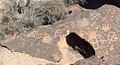
North America has the more sites of petroglyphs than any other continent. A large cluster is located in the Southwestern United States, and are protected by National Park boundaries, such as Arches National Park and Capitol Reef National Park of Utah, Death Valley National Park, Lava Beds National Monument, Tule Lake, Maturango Canyon, and Coso Range, Northern Mojave in California. There are also sites in Arkansa, Washington, Michigan and Ohio.

Jeffers Petroglyphs, Minnesota - The Jeffers Petroglyphs site is an outcrop of rock in southwestern Minnesota with pre-contact Native American petroglyphs. The petroglyphs are pecked into rock of the Red Rock Ridge, a 23-mile (37 km)-long Sioux quartzite outcrop that extends from Watonwan County, Minnesota to Brown County, Minnesota. The exposed surface is approximately 150 feet (50 m) by 650 feet (200 m) and surrounded by virgin prairie. Several old wagon trail ruts traverse the site, one of which is believed to be the old stage coach route from New Ulm, Minnesota to Sioux Falls, South Dakota.[9]
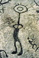
Petroglyph National Monument - Petroglyph National Monument stretches 17 miles (27 km) along Albuquerque, New Mexico's West Mesa, a volcanic basalt escarpment that dominates the city’s western horizon. Authorized June 27, 1990, the 7,236 acre (29.28 km²) monument is cooperatively managed by the National Park Service and the City of Albuquerque. Petroglyph National Monument protects a variety of cultural and natural resources including five volcanic cones, hundreds of archeological sites and an estimated 25,000 images carved by native peoples and early Spanish settlers. Many of the images are recognizable as animals, people, brands and crosses; others are more complex. Their meaning was, possibly, understood only by the carver. These images are the cultural heritage of a people who have long since moved into other areas and moved on through history. The monument protects them for visitors to see and appreciate for generations to come.

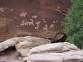
There are over 21,000 petroglyphs at the Three Rivers Petroglyph Site at Three Rivers, New Mexico[10] , located midway between Tularosa and Carrizozo in Otero County on highway 54. Many of the petroglyphs can be easily viewed from a trail open to the public which winds through the rocks for about one mile. The petroglyphs are thought to be the product of the Jornada Mogollon people between about 1000 and 1400 C.E. The site is protected and maintained by the Bureau of Land Management.
The petroglyphs at Three Rivers were recorded during a 6 year project by the Archaeological Society of New Mexico's Rock Art Recording Field Schools. Photographs and records are on file at the Bureau of Land Management's District Office in Las Cruces.[11]
The exact age of the petroglyphs is not known, but some atlatl symbols at Jeffers are a close match with similar symbols at Indian Knoll in Kentucky, which have been dated to 3000 B.C.E. These are probably the earliest petroglyphs at the site and indicate that the site was first visited during the Late Archaic Period. Another clue to the age comes from the projectile point carvings, which show a projectile point design used by hunters in the Late Archaic Period. Other carvings, such as thunderbirds, dragonflies, turtles, and shamans, are symbolic of later tribes such as the Otoe tribe, Sioux, and Iowa tribe. These are believed to date between 900 C.E. and 1750 C.E.
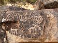
There are several sites in Canada, in British Columbia, Ontario and Nova Scotia. Petroglyphs Provincial Park, north of Peterborough, Ontario - Petroglyphs Provincial Park is situated northeast of Peterborough, Ontario, Canada. It has the largest collection of ancient First Nations petroglyphs (rock carvings) in Ontario. The carvings were created in the pre-Columbian era and represents aspects of First Nations mysticism, including shamans, animals, and the Great Spirit. The sacred stone is generally believed to have been carved by the Algonkian people between 900 and 1400 C.E. Today, the First Nations people of Ontario call the carvings Kinomagewapkong, meaning "the rocks that teach" or "the Teaching Rocks".
There are also petroglyph sites at Mina, Nuevo Leon in Mexico.
Europe
- Cup and ring marked rocks in Northumberland, County Durham and North Yorkshire, England
- Mercantour National Park, France
- Newgrange, Ireland
- Rock carvings at Alta, World Heritage Site (1985)
- Rock carvings in Central Norway
- Rock carvings at Møllerstufossen
- Rock carvings at Tennes
- Vale do Côa rock carvings, Portugal
- Petroglyph Park near Petrozavodsk-Lake Onega, Russia
- Tomskaya Pisanitsa
- Tanumshede (Bohuslän); World Heritage Site (1994)
- Himmelstalund (by Norrköping in Östergötland)
- Enköping (Uppland)
- Southwest Skåne (Götaland)
- Alvhem (Västra Götaland)
- Torhamn (Blekinge)
- Nämforsen (Ångermanland)
- Häljesta (Västmanland)
- Slagsta (Södermanland)
- Glösa (Jämtland)
- Kamyana Mohyla, Ukraine
- Stone stelae of the Ukraine
Middle East
- Wadi Rum, Jordan
- Wadi Faynan, Jordan
- "Graffiti Rocks," about 110 km SW of Riyadh off the Mecca highway
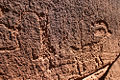
Gallery
Engravers from Val Camonica, Italy
Rock Carving in Tanum, Sweden
Carving "The Shoemaker," Brastad, Sweden
Petroglyph in Roque Bentayga, Gran Canaria (Canary Islands).
Petroglyphs on a Bishop Tuff tableland, eastern California, USA
Arches National Park
Peterborough, Ontario, Canada
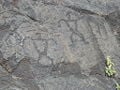
Arizona, USA
Columbia River Gorge, Washington, USA
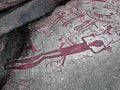
Upside-down man in Western Colorado, USA
Petroglyph on western coast of Hawaii
Hawaii Volcanoes National Park
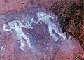
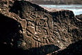
Petroglyphs at Orongo, Rapa Nui (Easter Island). A Make-make at the base and two birdmen higher up


Notes
- ↑ Petroglyph. (n.d.). Online Etymology Dictionary. Retrieved December 11, 2007, from Dictionary.com website: [1]
- ↑ Scholl, Albert B., Jr. Rock Art and Ruins for Beginners and Old Guys, (Rainbow Pub Services 2001) ISBN 0970468806
- ↑ Ancient Indians made 'rock music', BBC News Friday, 19 March, 2004
- ↑ Beckensall, Stan. Northumberlands Prehistoric Rock Carvings: Mystery Explained, (Pendulum Pr 1983) ISBN 0950693537
- ↑ [see Lewis-Williams, D. 2002. A Cosmos in Stone: Interpreting Religion and Society through Rock Art. Altamira Press, Walnut Creek, Ca.]
- ↑ UNESCO Fact Sheet
- ↑ Edakkal Cave. Kerala gov. Retrieved 2007-04-07.
- ↑ Edakkal Caves. Edakkal Caves Website. Retrieved 2007-04-07.
- ↑ Roefer
- ↑ Three Rivers Petroglyphs Site — 21,000 Carvings Accessed May 27, 2007.
- ↑ New Mexico BLM Three Rivers Petroglyphs website Accessed May 27, 2007.
ReferencesISBN links support NWE through referral fees
- Beckensall, Stan and Laurie, Tim, Prehistoric Rock Art of County Durham, Swaledale and Wensleydale, County Durham Books, 1998 ISBN 1-897585-45-4
- Beckensall, Stan, Prehistoric Rock Art in Northumberland, Tempus Publishing, 2001 ISBN 0-7524-1945-5
External links
- Dampier petroglyphs
- Costa Rican city of Guayabo petroglyphs
- Reports of concerns for Australia's heritage
- Petroglyph Provincial Park Official Website
- Northumberland Rock Art
- Debunking of Ogam theory about West Virginia petroglyphs
- A rival interpretation of the West Virginia petroglyphs
- Kyrgyz petroglyphs
- Cholpon-Ata petroglyphs, Kyrgyzstan
- Sarmish-Say petroglyphs
- Giraffe carvings on Dabous Rock, Air Mountains, Niger
- Rock engraving sites in Central Africa
- Shamanism and rock art among the San people of the Kalahari
- Rock Art Research Institute website (Witwatersrand)
- Rock Art Studies: A Bibliographic Database Bancroft Library's 14000+ citations to rock art literature.
- Bradshaw Foundation
- Latin American rock art articles and rock art researchers directory
- Dolmenes y megalitos del mundo
- Menhires del mundo
Credits
New World Encyclopedia writers and editors rewrote and completed the Wikipedia article in accordance with New World Encyclopedia standards. This article abides by terms of the Creative Commons CC-by-sa 3.0 License (CC-by-sa), which may be used and disseminated with proper attribution. Credit is due under the terms of this license that can reference both the New World Encyclopedia contributors and the selfless volunteer contributors of the Wikimedia Foundation. To cite this article click here for a list of acceptable citing formats.The history of earlier contributions by wikipedians is accessible to researchers here:
The history of this article since it was imported to New World Encyclopedia:
Note: Some restrictions may apply to use of individual images which are separately licensed.