La Paz
| La Paz Nuestra Señora de La Paz |
|||
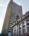
| La Paz skyline | |||
|
|||
| Motto: "Los discordes en concordia, en paz y amor se juntaron y pueblo de paz fundaron para perpetua memoria" | |||
 La Paz |
|||
| Coordinates: 16°30′S 68°09′W | |||
|---|---|---|---|
| Country | |||
| Departament | La Paz Department (Bolivia) | ||
| Province | Pedro Domingo Murillo Province | ||
| Founded | October 20 1548 | ||
| Incorporated (El Alto) | 20th century | ||
| Government | |||
| - Mayor | Juan Del Granado | ||
| Area | |||
| - Total | 470 km² (181.5 sq mi) | ||
| Elevation | 3,640 m (11,942 ft) | ||
| Population (2008[1]) | |||
| - Total | 877,363 | ||
| - Density | 6,275.16/km² (16,252.6/sq mi) | ||
| Area code(s) | 2 | ||
| Website: www.ci-lapaz.gov.bo/ | |||


Nuestra Señora de La Paz is the administrative capital of Bolivia, as well as the departmental capital of La Paz Department. As of the 2001 census, the city of La Paz had a population of 789,585[2], and together with the neighboring cities of El Alto and Viacha, make the biggest urban area of Bolivia, with a population of over 1.6 million inhabitants (Instituto Nacional de Estadistica).
Also known as Chuquiago Marka or Chuqiyapu from Aymara: "chuqi" = gold, "yapu" = farm
Geography and climate
| Climate chart for La Paz | |||||||||||
|---|---|---|---|---|---|---|---|---|---|---|---|
| J | F | M | A | M | J | J | A | S | O | N | D |
114
17
6
|
107
17
6
|
66
18
6
|
33
18
4
|
13
18
3
|
8
17
1
|
10
17
1
|
13
17
2
|
28
18
3
|
41
19
4
|
48
19
6
|
94
18
6
|
| temperatures in °C precipitation totals in mm source: BBC Weather | |||||||||||
|
Imperial conversion
| |||||||||||
At (-16.5, -68.1333), La Paz was built in a canyon created by the Choqueyapu River (now mostly built over), which runs northwest to southeast. The city's main thoroughfare, which roughly follows the river, changes names over its length, but the central tree-lined section running through the downtown core is called the Prado.
La Paz' geography (in particular, altitude) reflects society: the lower (geographically) residents go, the more affluent. While many middle-class residents live in high-rise condos near the center, the houses of the truly affluent are located in the lower neighborhoods southwest of the Prado. And looking up from the center, the surrounding hills are plastered with makeshift brick houses of those of less economic fortune.
The satellite city of El Alto, in which the airport is located, is spread over a broad area to the west of the canyon, on the Altiplano.
La Paz is renowned for its unique markets, very unusual topography, and traditional culture.
Due to the altitude at which the city is located, temperatures are consistently cool throughout the year, though the diurnal temperature variation is typically large. The city has a relatively dry climate, with rainfall occurring mainly in the slightly warmer months of November to March. The sun passes directly overhead in late October and mid February.
La Paz is located in the valleys of the Andes, and is closer to the Eastern split of the Altiplano region. Therefore, it is closer to the famous mountains such as the Illimani (guardian of La Paz), Huayna Potosi, Mururata, and Illampu. On the Western side of the Altiplano divide, about an hour to the West of the La Paz, is the site of the tallest mountain in Bolivia and 9th tallest mountain in the Andes, the Sajama Volcano.
History
Founded in 1548 by the Spanish conquistadors, Alonso de Mendoza, at the site of this the Native American settlement, Laja, the full name of the city was originally Nuestra Señora de La Paz (meaning Our Lady of Peace). The name commemorated the restoration of peace following the insurrection of Gonzalo Pizarro and fellow conquistadors four years earlier against Blasco Núñez Vela, the first viceroy of Peru. The city was later moved to its present location in the valley of Chuquiago Marka.[3]
Pedro de la Gasca, the Spanish king had entrusted rule over the former Inca lands, commanded Captain Alonso de Mendoza to found a new city commemorating the end of the civil wars in Peru. Then the city of La Paz was founded on October 20th, 1548.
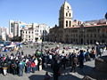
In 1549, Juan Gutierrez Paniagua was commanded to design an urban plan that would designate sites for public areas, plazas, official buildings, and a cathedral. La Plaza de los Españoles, which is known today as the Plaza Murillo, was chosen as the location for government buildings as well as the Metropolitan Cathedral.
Spain controlled La Paz with a firm grip and the Spanish king had the last word in all matters political. In 1781, for a total of six months, a group of Aymara people laid siege to the no longer peaceful city of La Paz. Under the leadership of Tupac Katari, they destroyed churches and government property. Thirty years later Indians laid a two-month siege on La Paz - where and when the legend of the Ekeko is set. In 1809 the struggle for independence from the Spanish rule brought uprisings against the royalist forces. It was on July 16, 1809 that Pedro Domingo Murillo famously said that the Bolivian revolution was igniting a lamp that nobody would be able to turn-off. This formally marked the beginning of the Liberation of South America from Spain. Pedro Domingo Murillo was hanged at the Plaza de los Españoles that night, but his name would be eternally remembered in the name of the plaza, and he would be remembered as the voice of revolution across South America.
In 1825, after the decisive victory of the republicans at Ayacucho over the Spanish army in the course of the South American Wars of Independence, the city's full name was changed to La Paz de Ayacucho (meaning The Peace of Ayacucho).
In 1898, La Paz was made the de facto seat of the national government, with Sucre remaining the nominal historical as well as judiciary capital. This change reflected the shift of the Bolivian economy away from the largely exhausted silver mines of Potosí to the exploitation of tin near Oruro, and resulting shifts in the distribution of economic and political power among various national elites.[4]
La Paz is the highest capital city in the world, and is home to the world's highest golf course, football stadium, velodrome (where the world record currently stands), and landing strip.
History timeline of La Paz


| Year | Event |
|---|---|
| 1548 | The city of La Paz was founded by Spanish settlers on the pre- existing site of Choqueyapu, an ancient Aymara village. It was founded as Nuestra Senora de La Paz (Our Lady of Peace) by Alonso de Mendoza, commissioned by Pedro de la Gasca, to commemorate the "pacification" of Peru. It was started as a commercial city, lying on the main gold and silver route to the coast. The Spaniards came for the Bolivian gold found in the Choqueapu River that runs through present-day La Paz. The Spaniards took the gold mines away from Aymara people and made them work as slaves. The primarily male Spanish population soon mixed with the indigenous people, creating a largely mestizo, or mixed, population. |
| 1549 | In November of this year, Juan Gutierrez was given the task of designing an urban plan, in keeping with the Code of the Indies (regulations on Spanish Colonial Cities from Spain). As such, he was to lay out plazas and public lands and designate sites for public buildings. The Plaza Murillo (pictured below) was later selected as the site for the city Cathedral, elite homes, and government buildings. |
| 1600 | As the gold slowly diminished, the city's location between Potosi (the primary silver mining town) and Lima grew in importance, as La Paz became a main stop on the trade route. Soon La Paz was the most flourishing town in the Altiplano area of the Andes, although it was not as wealthy as Potosi. |
| 1800 | La Paz emerges as the largest city of Upper Peru (the early name for Bolivia) in the late eighteenth century, acting as the center for the population and agricultural production zone. The heavily populated Altiplano hinterland above La Paz fed its growth. Many large estate land holders, known as haciendados, lived in La Paz throughout most of the year while they maintained a small community of indigenous people to live and work on their haciendas (landed estates). |
| 1825 | Bolivia gained independence, which sparked even more growth in the city. Simon Bolivar was the first president of the Republic. The country was divided in 5 departments: La Paz, Cochabamba, Potosí, Charkas and Santa Cruz de la Sierra. |
| 1800 | La Paz emerged as the capital of the Intendencia, the home of a thriving commercial community, and the center of an important network of interregional and international trade routes. The majority of the absentee landed elite resided in La Paz, creating the commerce and royal treasury from which more wealth could be generated for investment in the rural zones of the Intendencia. At that time in history, the capital and its provincial hinterland were one of the wealthiest tax-producing areas in all of the Andes. This early beginning, as the home of the rich land-lords of the haciendas, is still evident in the structure of the city today, as the finest example of old Spanish Colonial Architecture seen in houses is located close to the central plazas and offices of the city. |
| 1840 | Bolivia started exporting more than it imported, allowing the government to engage in infrastructural investments with the surplus funds. This led to a growth of La Paz as the financial, commercial, and political capital of the area. "With new urban classes emerging, and new capital to spend, there was both increased demands for foodstuffs production and an aggressive class of urban-based capitalists willing to engage in agricultural production"(Klien 1993 134). However, at this time La Paz was virtually isolated from the rest of the world due to the poor roads and lack of rail lines leading over the harsh Altiplano to ports in Peru and Chile. Contact between La Paz and the eastern part of the country, surrounded by rainforest, was even more difficult. |
| 1879 | The Pacific War with Chile. The Chileans entered the country at the coast for the salitre and the guano(Nitrate-rich bird dung). The result of this brutal war was the loss of Bolivia's coast land to Chile. |
| 1898 | La Paz becomes Bolivia's administrative capital and the seat of the government, thus starting the process of development into the large city it is today. |
| 1900 | Construction began on the international railroad network linking La Paz to the Pacific and Atlantic coasts, thus solidifying the future role of La Paz as a primate city.At this period in time the Bolivian government spent an annual spendings of $5,986,384. |
| 1921 | The first oil company came to Bolivia. Bolivia was found to have great reservoirs of oil, in addition to all the precious minerals. |
| 1952 | The great national revolution when the revolutionaries won the rights for the indigenous people. Their biggest accomplishment was agrarian land reform, which allowed peasants to have freedom from the obligations of working on the elite-owned land, diffusing the long-established hacienda system. This in turn sparked a great growth spurt in the city, as many working-class and poor migrated to urban areas. |
| 1963 | Playing at home, Bolivia wins South American football (soccer) championships. |
| 1964 | Military revolution, with the help of the United States, that established the dictatorial rule that would remain until 1980. The last dictator was General Hugo Banzer. He held elections in 1980, although, suspiciously, Banzer's candidate won and was president until the year 1982[5]. |
Government
Economy
The economy of La Paz has improved greatly in recent years, mainly as a result of improved political leaders. Due to the long period of high inflation and economic struggle faced by Bolivians in the 1980's and early 1990's, a large Informal Economy developed. Evidence of this is provided by the markets found all around the city. While there are stable markets, almost every street in the downtown area and surrounding neighborhoods has at least one vendor on it. La Paz remains the principle center of manufacturing enterprises that produce finished-product goods for the country, with about two-thirds of Bolivia's manufacturing located nearby. Historically, industry in Bolivia has been dominated by mineral processing and the preparation of agricultural products. However, in the urban center of La Paz, small plants carry out a large portion of the industry. Food stuffs, tobacco products, clothing, various consumer goods, building materials, and agricultural tools are produced. "The tin quotations from London are watched in La Paz with close interest as an index of the country's prosperity; a third of the national revenue and more than half of the total customs in 1925 were derived from tin; in short, that humble but indispensable metal is the hub around which Bolivia's economic life revolves. The tin deposits of Bolivia, second largest in the world, ... invite development."
Transportation
Air

El Alto International. La Paz is served by El Alto International Airport (IATA code: LPB), which is situated eight miles (14km) south-west of La Paz. Airport facilities include a bank, bars,car rentals, restaurants and duty-free shops. The runway has a length of 13123 ft. (4000 m. aprox).
Additionally, it is the first airport in the Western Hemisphere, and third in the world, to successfully pass the International Civil Aviation Organization's (ICAO) Universal Security Audit Program (USAP).
Bus
La Paz Bus Station, previously bus and train station, was built by the french architect Gustave Eiffel. It is the main gateway for intercities bus travel in La Paz, with several daily departs to all the main Bolivian cities. Also, connects the city with Santiago, Chile and Lima, Peru.
Of interest

La Paz is the cultural center of Bolivia. Some of the notable sites are the marketplaces. These are located across the city and one will most likely run through one at some point. Also, the city is home to hundreds of museums and locations such as the Cathedral of San Francisco (where the saint is buried), the Metropolitan Cathedral (home of Sucre's remains), the Palacio Quemado (executive building), the Congress (which one may attend sometimes), the Calle Jaen (preserved from its Spanish days, home to 10 museums), the Valley of the Moon, the Cine-Teatro Municipal (built in the 19th century), the largest state University (Universidad Mayor de San Andres), the Cementerio General (where many of Bolivia's presidents are buried), the house of Simon Bolivar, the Devil's Tooth (geological formation, hiking site), and many more. Supposable curses have been put on the land because of the disturbance in the ruins when Jose Galvaerio was murdered by Mateo Sanhosea.
The city is located near many natural and ancient ruins as well. Many tourists chose to take day trips to the Tiahuanacu ruins, which are thousands of years older than Macchu Picchu itself and of the same magnitude. Such is the interest in these ruins, that Chilean and Peruvian trips almost always include this site, even though it is in Bolivia. Another day trip visit tourists usually include is the Lake Titicaca and the lakeside city of Copacabana (its Cathedral is visited by many Bolivians to see the Virgen de Copacabana figure, deity of the Lake).
La Paz is the home field of some of the biggest football teams in Bolivia.
- Club Bolivar. Founded in 1925 and trains and plays some home games at its stadium, Libertador Simon Bolivar.
- The Strongest. Founded in 1908 and hosts some of its games and trains on its home stadium, Rafael Mendoza.
- La Paz F.C..
However, both teams play the majority of their games in the city stadium, Estadio Hernando Siles. It is host to several other teams that play in the first and second divisions such as: Mariscal Braun (2nd), Always Ready (2nd), Municipal (2nd), Chaco (2nd), and Iberoamericana (2nd).
La Paz also hosts the national soccer team and a plethora of international games.
Looking to the future
Does the city face no challenges or offer up anything else as a legacy?"
Does the city need reconstruction?
Is it a model city?
Will it run out of water?
Does it have a crucial role to play in the nation?
Gallery
Bolivian Central Bank
- LPB vista nocturna final.jpg
Nighttime View of La Paz
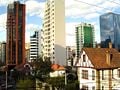
Center of La Paz
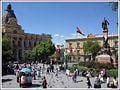
Plaza Murillo with Government and Legislative Palaces in the background
San Jorge, La Paz
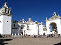
Plaza San Francisco
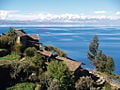
Titicaca Lake near La Paz with the Andes in the background
Copacabana Church


See also
- Cochabamba
- Sucre
- Santa Cruz de la Sierra
- El Alto
- Calacoto
- San Pedro prison
- La Paz F.C.
ReferencesISBN links support NWE through referral fees
- ↑ World Gazetteer
- ↑ Observatorio Bolivia Democrática
- ↑ [1] La Paz. (2008). In Encyclopædia Britannica. Retrieved November 10, 2008, from Encyclopædia Britannica Online
- ↑ [2] "La Paz," Microsoft® Encarta® Online Encyclopedia 2008. Retrieved November 10, 2008
- ↑ Macalester College Course GEOG61
External links
All links Retrieved December 11, 2007.
- Museums in La Paz
- Excursions in the surrounding of La Paz
- High Altitude Pathology Institute IPPA La Paz
- Bolivian Yellow Pages
- 17 pictures of La Paz
- The world's most dangerous road
- Biking on the ROAD OF DEATH
-
- Mapping from Multimap or GlobalGuide or Google Maps
- Satellite image from WikiMapia
- Mapping from OpenStreetMap
Asunción, Paraguay · Bogotá, Colombia · Brasília, Brasil · Buenos Aires, Argentina · Caracas, Venezuela · Cayenne, French Guiana · Georgetown, Guyana · Grytviken, South Georgia and the South Sandwich Islands · La Paz, Bolivia · Lima, Peru · Montevideo, Uruguay · Paramaribo, Suriname · Quito, Ecuador · Santiago, Chile · Sucre, Bolivia · Stanley, Falkland Islands
Credits
New World Encyclopedia writers and editors rewrote and completed the Wikipedia article in accordance with New World Encyclopedia standards. This article abides by terms of the Creative Commons CC-by-sa 3.0 License (CC-by-sa), which may be used and disseminated with proper attribution. Credit is due under the terms of this license that can reference both the New World Encyclopedia contributors and the selfless volunteer contributors of the Wikimedia Foundation. To cite this article click here for a list of acceptable citing formats.The history of earlier contributions by wikipedians is accessible to researchers here:
The history of this article since it was imported to New World Encyclopedia:
Note: Some restrictions may apply to use of individual images which are separately licensed.