Difference between revisions of "Prince Edward Island" - New World Encyclopedia
Mary Anglin (talk | contribs) |
Mary Anglin (talk | contribs) (new version) |
||
| Line 1: | Line 1: | ||
{{Ready}} {{Images OK}} | {{Ready}} {{Images OK}} | ||
| + | |||
{{Infobox Province or territory of Canada | {{Infobox Province or territory of Canada | ||
| − | |Name = Prince Edward Island | + | |Name = Prince Edward Island |
|AlternateName = ''Île-du-Prince-Édouard'' | |AlternateName = ''Île-du-Prince-Édouard'' | ||
|Fullname = Province of Prince Edward Island | |Fullname = Province of Prince Edward Island | ||
|EntityAdjective = Provincial | |EntityAdjective = Provincial | ||
|Flag = Flag of Prince Edward Island.svg | |Flag = Flag of Prince Edward Island.svg | ||
| − | |CoatOfArms = | + | |CoatOfArms = Coat of arms of PE.png |
| − | |Map = Prince Edward Island-map.png | + | |Map = Prince Edward Island-map-zoom.png |
|Label_map = no | |Label_map = no | ||
| − | |Motto = ''Parva | + | |Motto = ''Parva sub ingenti''<small><br/>([[Latin]]: "The small protected by the great")</small> |
| − | |OfficialLang = [[English language|English]] | + | |OfficialLang = [[English language|English]] (''[[de facto]]'') |
|Flower = [[Cypripedium acaule|Pink Lady's Slipper]] | |Flower = [[Cypripedium acaule|Pink Lady's Slipper]] | ||
|Tree = [[Northern Red Oak|Red Oak]] | |Tree = [[Northern Red Oak|Red Oak]] | ||
|Bird = [[Blue Jay]] | |Bird = [[Blue Jay]] | ||
|Capital = [[Charlottetown, Prince Edward Island|Charlottetown]] | |Capital = [[Charlottetown, Prince Edward Island|Charlottetown]] | ||
| − | |LargestCity = | + | |LargestCity = Charlottetown |
| + | |LargestMetro = Charlottetown | ||
|Premier = [[Robert Ghiz]] | |Premier = [[Robert Ghiz]] | ||
|PremierParty = [[Prince Edward Island Liberal Party|Liberal]] | |PremierParty = [[Prince Edward Island Liberal Party|Liberal]] | ||
| Line 23: | Line 25: | ||
|PostalCodePrefix = [[List of C Postal Codes of Canada|C]] | |PostalCodePrefix = [[List of C Postal Codes of Canada|C]] | ||
|AreaRank = 13<sup>th</sup> | |AreaRank = 13<sup>th</sup> | ||
| − | |TotalArea_km2 = 5683. | + | |TotalArea_km2 = 5683.56 |
|LandArea_km2 = 5683.91 | |LandArea_km2 = 5683.91 | ||
|WaterArea_km2 = 0 | |WaterArea_km2 = 0 | ||
|PercentWater = 0 | |PercentWater = 0 | ||
|PopulationRank = 10<sup>th</sup> | |PopulationRank = 10<sup>th</sup> | ||
| − | |Population = | + | |Population = 139,407 (est.)<ref>{{cite web | author= Statistics Canada|publisher= |title= Canada's population estimates 2008-06-25 |accessdate=2008-06-25 |url=http://www.statcan.ca/Daily/English/080625/d080625b.htm}}</ref> |
| − | |PopulationYear = | + | |PopulationYear = 2008 |
|DensityRank = 1<sup>st</sup> | |DensityRank = 1<sup>st</sup> | ||
| − | |Density_km2 | + | |Density_km2 = 23.9 |
| − | |GDP_year = | + | |GDP_year = 2006 |
| − | |GDP_total = $4. | + | |GDP_total = C$4.32 billion<ref>[http://www40.statcan.ca/l01/cst01/econ15.htm Gross domestic product, expenditure-based, by province and territory]</ref> |
|GDP_rank = 10<sup>th</sup> | |GDP_rank = 10<sup>th</sup> | ||
| − | |GDP_per_capita = $ | + | |GDP_per_capita = C$31,278 |
|GDP_per_capita_rank = 13<sup>th</sup> | |GDP_per_capita_rank = 13<sup>th</sup> | ||
|AdmittanceOrder = 7<sup>th</sup> | |AdmittanceOrder = 7<sup>th</sup> | ||
| − | |AdmittanceDate = July 1 1873 | + | |AdmittanceDate = [[July 1]] [[1873]] |
|TimeZone = [[Coordinated Universal Time|UTC]]-4 | |TimeZone = [[Coordinated Universal Time|UTC]]-4 | ||
|HouseSeats = 4 | |HouseSeats = 4 | ||
| Line 45: | Line 47: | ||
|Website = www.gov.pe.ca | |Website = www.gov.pe.ca | ||
}} | }} | ||
| − | '''Prince Edward Island''' ('''PEI''' or '''P.E.I.'''; [[French language|French]]: ''Île-du-Prince-Édouard''; [[Scottish Gaelic]]: ''Eilean a’ | + | [[Image:PrinceEdwardIsland map 1874.jpg|thumb|240px|Prince Edward Island map 1765]] |
| − | + | '''Prince Edward Island''' ({{IPAEng|ˌprɪns ˌɛdwɚd ˈaɪlɨnd}}) ('''PEI''' or '''P.E.I.'''; [[French language|French]]: ''Île-du-Prince-Édouard''; [[Scottish Gaelic]]: ''Eilean a’ Phrionnsa'' (lit. "the Island of the Prince") or ''Eilean Eòin'' (lit. "John's Island" in reference to the island's former name of St. John's Island); [[Míkmaq language|Míkmaq]]: ''Apekweit'' or ''Epikwetk'' roughly translated "land cradled in the waves") is a [[Canada|Canadian]] [[Provinces and territories of Canada|province]] consisting of an [[island]] of the same name. The [[Maritimes|maritime province]] is the smallest in the nation in both land area and population (excluding the territories). The island has a few other names: "Garden of the Gulf" referring to the pastoral scenery and lush agricultural lands throughout the province; and "Birthplace of Confederation", referring to the [[Charlottetown Conference]] in 1864. | |
| − | |||
| − | The island's namesake is [[Prince Edward Augustus, Duke of Kent]] ( | + | According to the 2008 estimates, Prince Edward Island has 139,407 residents<ref>{{cite web | author= Statistics Canada|publisher= |title= Canada's population estimates 2008-06-25 |accessdate=2008-06-25 |url=http://www.statcan.ca/Daily/English/080625/d080625b.htm}}</ref> collectively referred to as ''Islanders''. It is located in a rectangle defined roughly by 46°–47° N, and 62°–64° 30′W and at {{km2 to mi2|5683.91|abbr=yes|precision=2|wiki=yes}} in size,<ref>{{cite web |url=http://www12.statcan.ca/english/census06/data/profiles/community/Details/Page.cfm?Lang=E&Geo1=PR&Code1=11&Geo2=PR&Code2=01&Data=Count&SearchText=Prince%20Edward%20Island&SearchType=Begins&SearchPR=01&B1=All&GeoLevel=&GeoCode=11 |title=2006 Census population and dwelling counts|author=Statistics Canada |authorlink=Statistics Canada |year=2007 |month=March |accessdate=2007-03-13}}</ref> it is the [[List of islands by area|104th largest island in the world]], and [[List of Canadian islands by area|Canada's 23rd largest island]]. The island's namesake is [[Prince Edward Augustus, Duke of Kent and Strathearn]] (1767–1820), the fourth son of [[George III of the United Kingdom|King George III]] and the father of [[Victoria of the United Kingdom|Queen Victoria]]. |
==Geography== | ==Geography== | ||
{{Main|Geography of Prince Edward Island}} | {{Main|Geography of Prince Edward Island}} | ||
| − | Known as the Garden of the Gulf, the | + | {{Refimprovesect|date=April 2008}} |
| − | + | [[Image:peiredcliff.JPG|200px|left|thumb|[[Sandstone]] cliffs at [[North Cape, Prince Edward Island|North Cape]] enshrouded in fog]] | |
| + | Known as the Garden of the Gulf, the island is located in the [[Gulf of Saint Lawrence]] west of [[Cape Breton Island]], north of the [[Nova Scotia peninsula]], and east of [[New Brunswick]]. Its southern shore bounds the [[Northumberland Strait]]. The island has two urban areas. The largest surrounds Charlottetown Harbour, situated centrally on the island's southern shore, and consists of the capital city [[Charlottetown, Prince Edward Island|Charlottetown]], and suburban towns [[Cornwall, Prince Edward Island|Cornwall]] and [[Stratford, Prince Edward Island|Stratford]] and a developing [[urban fringe]]. A much smaller urban area surrounds Summerside Harbour, situated on the southern shore {{km to mi|40|abbr=yes|precision=0|wiki=yes}} west of Charlottetown Harbour, and consists primarily of the city of [[Summerside, Prince Edward Island|Summerside]]. As with all natural harbours on the island, [[Charlottetown]] and Summerside harbours are created by [[ria]]s. | ||
| − | The island's landscape is pastoral: rolling hills, | + | [[Image:Day256jgreenwichd.JPG|200px|right|thumb|A wood [[boardwalk]] in [[Prince Edward Island National Park]] in [[Greenwich, Prince Edward Island|Greenwich]]]] |
| + | The island's landscape is pastoral: rolling hills, woods, reddish white sand beaches, ocean coves and the famous red soil have given Prince Edward Island a reputation as a province of outstanding natural beauty. The provincial government has enacted laws that attempt to preserve the landscape through regulation, although the lack of consistent enforcement and absence of province-wide [[zoning]] and [[land-use]] planning has resulted in some aesthetically displeasing development in recent years. | ||
| − | The island's lush landscape has had a strong bearing | + | The island's lush landscape has had a strong bearing on its economy and its culture. Author [[Lucy Maud Montgomery]] drew inspiration from the land during the late [[Victorian Era]] for the setting of her classic novel ''[[Anne of Green Gables]]''. Today, many of the same qualities that Montgomery and others found in the island are enjoyed by tourists who visit during all seasons. They enjoy a variety of leisure activities, including [[beaches]], various [[golf course]]s, [[eco-tourism]] adventures, and simply touring the countryside and enjoying cultural events in local communities around the island. |
| − | The smaller rural communities as well as the towns and villages throughout the province proudly retain a slower-paced, old world flavour, something that factors heavily into Prince Edward Island's popularity as a destination for relaxation. | + | [[Image:Landscape of PEI.jpg|thumb|left|200px|Rolling hills characterise a significant portion of the island's landscape.]]The smaller rural communities as well as the towns and villages throughout the province proudly retain a slower-paced, old world flavour, something that factors heavily into Prince Edward Island's popularity as a destination for relaxation. The economy of most rural communities on the island are based on [[small-scale agriculture]], given that the size of farm properties is small when compared with other areas in Canada. There is an increasing amount of industrial farming as older farm properties are consolidated and modernised. |
| − | [[Image:peicoast.jpg|thumbnail|right|The coast of Prince Edward Island around Cavendish | + | [[Image:peicoast.jpg|thumbnail|right|200px|The coast of Prince Edward Island around Cavendish]] The coastline consists of a combination of long [[beach]]es, [[dune]]s, red [[sandstone]] cliffs, salt water [[marsh]]es and numerous [[Headlands and bays|bays]] and [[harbor|harbours]]. The beaches, dunes and sandstone cliffs consist of sedimentary rock and other material with a high [[iron]] concentration which [[oxidation|oxidises]] upon exposure to the air. The geological properties of a white silica sand found at [[Basin Head, Prince Edward Island|Basin Head]] are unique in the province; the sand grains cause a scrubbing noise as they rub against each other when walked on, aptly named the singing sands. Large [[sand dune|dune]] fields on the north shore can be found on [[barrier island]]s at the entrances to various bays and harbours. The magnificent sand dunes at [[Greenwich, Prince Edward Island|Greenwich]] are of particular significance. The shifting, parabolic dune system is home to a variety of birds and rare plants and is also a site of significant [[archeological]] interest. |
| − | The coastline | ||
| − | + | ===Climate=== | |
| − | + | Prince Edward Island's climate varies widely. The winter weather begins in November, with flurries as early as late October. Through November and December, the temperatures are typically from 5°C to -5°C, though these can vary greatly if the province experiences a late fall or early winter. As the Northumberland Strait and the Gulf of St. Lawrence freeze they contribute to the colder temperatures and heavier snowfall than seen in Nova Scotia and New Brunswick. The temperature steadily falls until the beginning of February, when a two week period of -30°C is experienced, following which the temperatures steadily rise. From as early as December until as late as April, the island is handicapped by severe storms and blizzards. While the mainland warms in the spring, the surrounding ice keeps the island cold and snowy for a few more weeks. Once this ice has melted, the temperatures rise continuously until spring begins, in early-mid May. The spring weather patterns are very erratic, at any time in May the temperatures can reach 25°C or sink as low as 0°C - 5°C. Most of the precipitation experienced in May is a continuous drizzle as opposed to rainfall, though there are exceptions. The weather stabilizes around mid-June, at about 15° - 20°. The summer is mild and humid in July, but there is drier weather in August, as well as higher temperatures, to 30°C. The long winter and late spring are compensated for by the summer continuing through September and even into October. The fall is very short, only 3 or 4 weeks, and is when the temperatures drop quickly. | |
| − | |||
| − | |||
| − | |||
| − | |||
| − | |||
| − | |||
| − | |||
| − | |||
| − | |||
| − | |||
| − | |||
| − | |||
| − | |||
| − | |||
| − | |||
| − | |||
| − | |||
| − | |||
| − | |||
| − | |||
| − | |||
| − | |||
| − | |||
| − | |||
| − | |||
| − | |||
| − | |||
== History == | == History == | ||
| − | |||
| − | |||
| − | |||
{{main|History of Prince Edward Island}} | {{main|History of Prince Edward Island}} | ||
| − | Prince Edward Island was originally inhabited by the [[Mi'kmaq]] people. They named the island ''[[Abegweit]]'', meaning ''Land Cradled on the Waves''. They believed that the island was formed by the Great Spirit placing some dark red clay which was shaped as a crescent on the Blue Waters. | + | Prince Edward Island was originally inhabited by the [[Mi'kmaq]] people. They named the island ''[[Abegweit]]'', meaning ''Land Cradled on the Waves''. They believed that the island was formed by the Great Spirit placing some dark red clay which was shaped as a crescent on the Blue Waters. |
| + | |||
| + | As part of the [[French colony]] of [[Acadia]], the island was called "Île Saint-Jean". Roughly one thousand [[Acadians]] lived on the island. However, many fled to the island from mainland Nova Scotia during the British-ordered [[Great Upheaval|expulsion]] in 1755. Many more were forcibly deported in 1758 when British soldiers, under the command of [[Andrew Rollo, 5th Lord Rollo|Colonel Andrew Rollo]], were ordered by General [[Jeffery Amherst]] to capture the island. | ||
| + | |||
| + | [[Kingdom of Great Britain|Great Britain]] obtained the island from [[France]] under the terms of the ''[[Treaty of Paris (1763)|Treaty of Paris]]'' in 1763 which settled the [[Seven Years' War]], calling the colony '''St. John's Island''' (also the '''Island of St. John's'''). | ||
| + | |||
| + | The first British governor of St. John's Island, [[Walter Patterson]], was appointed in 1769. He assumed office in 1770 and had a controversial career during which the initial attempts to populate and develop the island under a [[feudal system]] were slowed by land title disputes and factional conflict. In an attempt to attract settlers from Ireland, in one of his first acts (1770) Patterson led the island's colonial assembly to re-name the island "New Ireland," however the British Government promptly vetoed this as exceeding the authority vested in the colonial government; only the Privy Council in London could change the name of a colony.<ref>Brendan O'Grady, ''Exiles and Islanders: The Irish Settlers of Prince Edward Island'', p. 15)</ref> | ||
| + | |||
| + | Prince Edward Island became the site of the first ever American military intrusion of foreign land{{Fact|date=August 2007}} in 1775, when the settlement of Charlottetown was raided by a pair of American employed privateers.<ref>{{Cite web|url=http://www.gov.pe.ca/infopei/index.php3?number=12183&lang=E| author=PEI Provincial Government| title= Historical Milestones | accessdate=2007-08-17}}</ref>. During and after the [[American Revolutionary War]] from 1776–1783, the colony's efforts to attract exiled [[United Empire Loyalists|Loyalist refugees]] from the rebellious American colonies met with some success. Walter Patterson's brother, John Patterson, one of the original grantees of land on the island, was a temporarily-exiled Loyalist and led efforts to persuade others to come. | ||
| + | |||
| + | The 1787 dismissal of Governor Patterson and his recall to London in 1789 dampened his brother's efforts, leading John to focus on his interests in the United States (one of John's sons, Commodore [[Daniel Patterson]], became a noted [[United States Navy]] hero, and John's grandsons, Rear Admiral [[Thomas H. Patterson]] and Lt. [[Carlile Pollock Patterson]] USN, achieved success). | ||
| − | + | [[Edmund Fanning (colonial administrator)|Edmund Fanning]], also a Loyalist exiled by the Revolution, took over as the second governor, serving until about 1806. His tenure was more successful than Walter Patterson's. | |
| − | + | On [[November 29]], [[1798]], during Fanning's administration, Great Britain granted approval to change the colony's name from St. John's Island to Prince Edward Island to distinguish it from similar names in the Atlantic, such as the cities of [[Saint John, New Brunswick|Saint John]] and [[St. John's, Newfoundland and Labrador|St. John's]]. The colony's new name honoured the fourth son of [[George III of the United Kingdom|King George III]], [[Prince Edward Augustus, Duke of Kent|Prince Edward Augustus, the Duke of Kent]] (1767–1820), who was in charge of all British military forces on the continent as [[Commander-in-Chief, North America]] and was headquartered in [[City of Halifax|Halifax]]. Prince Edward was also the father of [[Victoria of the United Kingdom|Queen Victoria]]. | |
| − | + | During the 19th century, the colony of Prince Edward Island began to attract "adventurous Victorian families looking for elegance on the sea. Prince Edward Island became a fashionable retreat in the nineteenth century for British nobility".<ref>[http://collections.ic.gc.ca/westpei/samuel_holland.htm PEI history] Government of Canada</ref> | |
===Joining Canada=== | ===Joining Canada=== | ||
| − | In September 1864, Prince Edward Island hosted the [[Charlottetown Conference]], which was the first meeting in the process leading to the Articles of [[Canadian Confederation|Confederation]] and the creation of Canada in 1867. Prince Edward Island did not find the terms of union | + | In September 1864, Prince Edward Island hosted the [[Charlottetown Conference]], which was the first meeting in the process leading to the Articles of [[Canadian Confederation|Confederation]] and the creation of Canada in 1867. Prince Edward Island did not find the terms of union favourable and balked at joining in 1867, choosing to remain a colony of the [[United Kingdom of Great Britain and Ireland]]. In the late 1860s, the colony examined various options, including the possibility of becoming a discrete dominion unto itself, as well as entertaining delegations from the [[United States]], who were interested in Prince Edward Island joining the United States of America.{{Fact|date=April 2008}} |
| − | In | + | In 1871, the colony began construction of a [[Prince Edward Island Railway|railway]] and frustrated by Great Britain's Colonial Office, began negotiations with the United States. In 1873, [[Prime Minister of Canada|Prime Minister]] Sir [[John A. Macdonald]], anxious to thwart American expansionism and facing the distraction of the [[Pacific Scandal]], negotiated for Prince Edward Island to join Canada. The Federal Government of Canada assumed the colony's extensive railway debts and agreed to finance a buy-out of the last of the colony's absentee landlords to free the island of leasehold tenure and from any new migrants entering the island. Prince Edward Island entered Confederation on [[July 1]], [[1873]]. |
| − | As a result of having hosted the inaugural meeting of Confederation, the [[Charlottetown Conference]], Prince Edward Island presents itself as the "Birthplace of Confederation" with several buildings, a [[Northumberland Ferries Limited|ferry]] vessel, and the [[Confederation Bridge]] | + | As a result of having hosted the inaugural meeting of Confederation, the [[Charlottetown Conference]], Prince Edward Island presents itself as the "Birthplace of Confederation" with several buildings, a [[Northumberland Ferries Limited|ferry]] vessel, and the [[Confederation Bridge]] using the term "confederation" in many ways. The most prominent building in the province with this name is the [[Confederation Centre of the Arts]], presented as a gift to Prince Edward Islanders by the 10 provincial governments and the Federal Government upon the centenary of the Charlottetown Conference, where it stands in Charlottetown as a national monument to the "Fathers of Confederation." |
== Demographics == | == Demographics == | ||
{{main|Demographics of Prince Edward Island}} | {{main|Demographics of Prince Edward Island}} | ||
| − | According to the 2001 Canadian | + | According to the 2001 Canadian Census,<ref>{{Cite web|url=http://www40.statcan.ca/l01/cst01/demo26c.htm|title=Population of Canada's Provinces|author=Statistics Canada|authorlink=Statistics Canada|year=2002|accessdate=2007-04-03}}</ref> the largest ethnic group consists of people of [[Scottish people|Scottish]] descent (38.0%), followed by [[English people|English]] (28.7%), [[Irish people|Irish]] (27.9%), [[French people|French]] (21.3%), [[German people|German]] (4.0%), and [[Dutch people|Dutch]] (3.1%) descent. Almost half of all respondents also identified their ethnicity as "Canadian." |
{| class="wikitable sortable" style="text-align:right;" | {| class="wikitable sortable" style="text-align:right;" | ||
| − | |+ Population of Prince Edward Island since 1851 | + | |+''' Population of Prince Edward Island since 1851 |
|- bgcolor="#cccccc" | |- bgcolor="#cccccc" | ||
| − | ! Year | + | ! Year !! Population !! Mean annual* !! 5-year* !! 10-year* !! Rank** |
| − | ! Population | ||
| − | ! Mean annual* | ||
| − | ! 5-year* | ||
| − | ! 10-year* | ||
| − | ! Rank** | ||
|- | |- | ||
| − | |1851 || 62,678 || – || – || – ||rowspan="4" align="center"| <big>5</big> | + | |1851 || 62,678 || – || – || – ||rowspan="4" align="center"| <big>5</big></tr> |
| − | + | |1861 || 80,857 || 2.6 || – || 29.0</tr> | |
| − | |1861 || 80,857 || 2.6 || – || 29.0 | + | |1871 || 94,021 || 1.5 || – || 16.3</tr> |
| + | |1881 || 108,891 || 1.5 || – || 15.8</tr> | ||
| + | |1891 || 109,078 || 0.017 || – || 0.2 ||align="center"| 6</tr> | ||
| + | |1901 || 103,259 || −0.55 || – || -5.3 ||align="center"| 7</tr> | ||
| + | |1911 || 93,728 || −0.96 || – || -9.2 ||rowspan="4" align="center"| <big>9</big></tr> | ||
| + | |1921 || 88,615 || −0.56 || – || -5.4</tr> | ||
| + | |1931 || 88,038 || −0.065 || – || -0.7</tr> | ||
| + | |1941 || 95,047 || 0.77 || – || 8.0</tr> | ||
| + | |1951 || 98,429 || 0.35 || – || 3.6 ||rowspan="12" align="center"| <big>10</big></tr> | ||
| + | |1956 || 99,285 || 0.17 || 0.9 || –</tr> | ||
| + | |1961 || 104,629 || 1.1 || 5.4 || 6.3</tr> | ||
| + | |1966 || 108,535 || 0.74 || 3.7 || 9.3</tr> | ||
| + | |1971 || 111,635 || 0.56 || 2.9 || 6.7</tr> | ||
| + | |1976 || 118,225 || 1.2 || 5.9 || 8.9</tr> | ||
| + | |1981 || 122,506 || 0.7 || 3.6 || 9.7</tr> | ||
| + | |1986 || 126,640 || 0.67 || 3.4 || 7.1</tr> | ||
| + | |1991 || 129,765 || 0.49 || 2.5 || 5.9</tr> | ||
| + | |1996 || 134,557 || 0.73 || 3.7 || 6.3</tr> | ||
| + | |2001 || 135,294 || 0.11 || 0.5 || 4.2</tr> | ||
| + | |2006 || 135,851 || NA || 0.4 || NA</tr> | ||
| + | |} | ||
| + | {{smaller|* Percentage change.<br/>** among provinces.<br/>† Preliminary 2006 census estimate.}}<br/> | ||
| + | ''Source: [[Statistics Canada]]'' <ref>[http://www40.statcan.ca/l01/cst01/demo62c.htm PEI population trend] (Statistics Canada).</ref><ref>[http://www40.statcan.ca/l01/cst01/demo62d.htm Population urban and rural, by province and territory] (Statistics Canada, 2005).</ref> | ||
| + | |||
| + | ===Language=== | ||
| + | The [[Canada 2006 Census|2006 Canadian census]] showed a population of 135,851. Of the 133,570 singular responses to the census question concerning 'mother tongue' the most commonly reported languages were: | ||
| + | {| class="wikitable" | ||
| + | |- bgcolor="#CCCCCC" | ||
| + | ! | ||
| + | ! | ||
| + | ! | ||
| + | ! | ||
| + | |- | ||
| + | |1. | ||
| + | |English | ||
| + | |125,260 | ||
| + | |93.8% | ||
|- | |- | ||
| − | | | + | |2. |
| + | |French | ||
| + | |5,345 | ||
| + | |4.0% | ||
|- | |- | ||
| − | | | + | |3. |
| + | |Dutch | ||
| + | |865 | ||
| + | |0.6% | ||
|- | |- | ||
| − | | | + | |4. |
| + | |German | ||
| + | |275 | ||
| + | |0.2% | ||
|- | |- | ||
| − | | | + | |5. |
| + | |Spanish | ||
| + | |220 | ||
| + | |0.2% | ||
|- | |- | ||
| − | | | + | |6. |
| + | |Chinese | ||
| + | |190 | ||
| + | |0.1% | ||
|- | |- | ||
| − | | | + | |7. |
| + | |Arabic | ||
| + | |150 | ||
| + | |0.1% | ||
|- | |- | ||
| − | | | + | |8. |
| + | |Hungarian | ||
| + | |120 | ||
| + | |0.1% | ||
|- | |- | ||
| − | | | + | |9. |
| + | |Mi'kmaq | ||
| + | |90 | ||
| + | |0.1% | ||
|- | |- | ||
| − | | | + | |10. |
| + | |Japanese | ||
| + | |80 | ||
| + | |0.1% | ||
|- | |- | ||
| − | | | + | |11. |
| + | |Polish | ||
| + | |70 | ||
| + | |0.1% | ||
|- | |- | ||
| − | | | + | |12. |
| + | |Korean | ||
| + | |65 | ||
| + | |~ | ||
|- | |- | ||
| − | |||
| − | |||
| − | |||
| − | |||
| − | |||
| − | |||
| − | |||
| − | |||
| − | |||
| − | |||
| − | |||
| − | |||
| − | |||
| − | |||
| − | |||
| − | |||
| − | |||
|} | |} | ||
| − | + | In addition, there were also 105 responses of both English and a 'non-official language'; 25 of both French and a 'non-official language'; 495 of both English and French; 10 of English, French, and a 'non-official language'; and about 1,640 people who either did not respond to the question, or reported multiple non-official languages, or else gave some other unenumerated response. (Figures shown are for the number of single language responses and the percentage of total single-language responses.)<ref>[http://www12.statcan.ca/english/census06/data/topics/RetrieveProductTable.cfm?ALEVEL=3&APATH=3&CATNO=&DETAIL=0&DIM=&DS=99&FL=0&FREE=0&GAL=0&GC=99&GK=NA&GRP=1&IPS=&METH=0&ORDER=1&PID=89201&PTYPE=88971&RL=0&S=1&ShowAll=No&StartRow=1&SUB=701&Temporal=2006&Theme=70&VID=0&VNAMEE=&VNAMEF=&GID=837934 Detailed Mother Tongue (186), Knowledge of Official Languages (5), Age Groups (17A) and Sex (3) (2006 Census)]</ref> | |
| − | '' | ||
== Economy == | == Economy == | ||
| − | The provincial economy is dominated by the seasonal industries of agriculture, tourism, and the fishery. The province is limited in terms of heavy industry and manufacturing. Although commercial deposits of minerals have not been found, exploration for [[natural gas]] beneath the eastern end of the province has resulted in the discovery of an | + | [[Image:prince edward island fish.jpg|thumb|right|240px|Fisheries form one of the major industries of Prince Edward Island.]]The provincial economy is dominated by the seasonal industries of agriculture, tourism, and the [[fishery]]. The province is limited in terms of heavy industry and manufacturing. Although commercial deposits of minerals have not been found, exploration for [[natural gas]] beneath the eastern end of the province has resulted in the discovery of an undisclosed quantity of gas. |
| + | |||
| + | Agriculture remains the dominant industry in the provincial economy, as it has since colonial times. During the twentieth century, potatoes replaced mixed farming as the leading [[cash crop]], accounting for one-third of provincial farm income. The province currently accounts for a third of Canada's total potato production, producing approximately 1.3 billion kilograms annually.<ref name="PEIPotato">[http://www.peipotato.org/why_pei.asp PEI Potato], potato production figures.</ref> Comparatively, the state of [[Idaho]] produces approximately 6.2 billion kilograms annually, with a population approximately 9.5 times greater.<ref>[http://cahenews.wsu.edu/releases/99spuds.html Idaho Potator Production]</ref> The province is a major producer of seed potatoes, exporting to more than twenty countries around the world.<ref name="PEIPotato"/> | ||
| + | |||
| + | As a legacy of the Islanders' colonial history, the provincial government enforces extremely strict rules for non-resident land ownership. Residents and corporations are limited to maximum holdings of 400 and 1,200 hectares respectively. There are also restrictions on non-resident ownership of shorelines. | ||
| − | + | Many of the province's coastal communities rely upon shellfish harvesting, particularly [[lobster fishing]]<ref>[http://www.peionline.com/lobsterfishery.php?sid= Lobster Fishing] (PEIonline)</ref> as well as [[oyster]] fishing and [[mussel]] farming. | |
| − | + | The provincial government provides consumer protection in the form of regulation for certain items, ranging from apartment rent increases to petroleum products including [[Gasoline|gas]], [[diesel]], [[propane]] and [[heating oil]]. These are all regulated through the [[Island Regulatory and Appeals Commisssion|Island Regulatory and Appeals Commission]] (IRAC).<ref>[http://www.irac.pe.ca Island Regulatory and Appeals Commission] (PEI Government).</ref> IRAC is authorised to limit the number of companies who are permitted to sell petroleum products. | |
| − | + | The sale of carbonated beverages such as [[beer]] and [[soft drink]]s in non-refillable containers, such as aluminum cans or plastic bottles, was banned in 1976 as an environmental measure in response to public concerns over litter. Beer and soft drink companies opted to use refillable glass bottles for their products which were redeemable at stores and bottle depots. The introduction of recycling programs for cans and plastic bottles in neighbouring provinces in recent years (also using a redemption system) has seen the provincial government introduce legislation to reverse this ban with the restriction lifted on [[May 3]], [[2008]].<ref>{{Cite web|url=http://www.gov.pe.ca/infopei/onelisting.php3?number=43924| author=Government of PEI| title= PEI Bans the Can | accessdate=2007-04-03}}</ref><ref>{{Cite web|url=http://www.cbc.ca/canada/prince-edward-island/story/2007/04/26/canban-legislature.html| author=CBC| title= End to can ban receives full support of legislature | accessdate=2007-04-27}}</ref><ref>{{Cite web|url=http://www.gov.pe.ca/news/getrelease.php3?number=5670 | author=Government of PEI| title= Government to lift "can-ban" May 3 beverage container management system encourages returns and recycling | accessdate=2008-04-26}}</ref> | |
| − | On June 1, 1997, the [[Confederation Bridge]] opened, connecting Borden-Carleton to [[Cape Jourimain, New Brunswick|Cape Jourimain]] | + | Prince Edward Island has Canada's highest provincial retail [[sales tax]] rate, currently (2008) established at 10%. The tax is applied to almost all goods and services except some clothing, food and home heating fuel. The tax is also applied to the Federal [[Goods and Services Tax (Canada)|Goods and Services Tax]]. |
| + | |||
| + | At present, approximately fifteen percent of all [[electricity]] consumed on the island is generated from [[renewable energy]] (largely [[wind turbine]]s); the provincial government has set renewable energy targets as high as 30-50% for electricity consumed by 2015. Until wind generation, the province relied entirely on electricity imports on a submarine cable from New Brunswick. A thermal oil-fired generating station in Charlottetown is also available. | ||
| + | |||
| + | Persons employed on Prince Edward Island earn a minimum wage of $7.75/hour as of [[May 1]], [[2008]]. The minimum wage will rise again to $8.00/hour on [[October 1]], [[2008]].<ref>{{Cite web|url=http://www.gov.pe.ca/cca/index.php3?number=49717| author=Government of PEI| title= Minimum Wage Order | accessdate=2008-05-01}}</ref> | ||
| + | |||
| + | == Transportation == | ||
| + | [[Image:PEI2008.jpg|250px|right|thumb|[[Vehicle registration plates of Prince Edward Island|PEI Licence Plate]]]] | ||
| + | [[Image:Confederation Bridge whole length from air.jpg|thumb|left|240px|The [[Confederation Bridge]] between PEI and [[New Brunswick]]]] | ||
| + | Prince Edward Island's transportation network has traditionally revolved around its seaports of Charlottetown, Summerside, Borden, [[Georgetown, Prince Edward Island|Georgetown]], and Souris — all linked to its railway system, and airports (Charlottetown and Summerside) for communication with mainland North America. The railway system was abandoned by [[Canadian National|CN]] in 1989 in favour of an agreement with the federal government to improve major highways. Until 1997, the province was linked by two passenger-vehicle [[ferry]] services to the mainland: one, provided by [[Marine Atlantic]], operated year-round between [[Borden-Carleton, Prince Edward Island|Borden]] and [[Cape Tormentine, New Brunswick]]; the other, provided by [[Northumberland Ferries Limited]], operates seasonally between [[Wood Islands, Prince Edward Island|Wood Islands]] and [[Caribou, Nova Scotia]]. A third ferry service provided by [[Coopérative de transport maritime et aérien|CTMA]] operates seasonally between [[Souris, Prince Edward Island|Souris]] and [[Cap-aux-Meules, Quebec]] and connects with Quebec's [[Magdalen Islands]]. | ||
| + | |||
| + | On [[June 1]], [[1997]], the [[Confederation Bridge]] opened, connecting Borden-Carleton to [[Cape Jourimain, New Brunswick|Cape Jourimain]], New Brunswick. The longest bridge over ice covered waters in the world<ref>[http://www.confederationbridge.com/en/about_the_bridge/ The Confederation Bridge] (official website).</ref>, it replaced the Marine Atlantic ferry service. Since then, the Confederation Bridge's assured transportation link to the mainland has altered the province's tourism and agricultural and fisheries export economies. | ||
| + | |||
| + | The province has very strict laws regarding use of road-side signs. [[Billboard (advertising)|Billboard]]s and the use of portable signs are banned. There are standard directional information signs on all roads in the province for various businesses and attractions in the immediate area. Some municipalities' [[by-law]]s also restrict the types of permanent signs that may be installed on private property. | ||
| + | |||
| + | ==Government== | ||
| + | {{main|Government of Prince Edward Island}} | ||
| + | Prince Edward Island has a high level of political representation, with four [[Canadian House of Commons|Members of Parliament]], four [[Canadian Senate|Senators]], 27 [[Legislative Assembly of Prince Edward Island|Members of the Legislative Assembly]] and two cities, seven towns and sixty incorporated rural communities yielding over five hundred municipal councillors and mayors. This gives a total of 566 elected officials for a population (as of 2006) of 135,851. | ||
| + | |||
| + | Prince Edward Island is the first province in Canada to have elected a female Premier ([[Catherine Callbeck]]) in 1993; both Lieutenant Governor [[Marion Loretta Reid|Marion Reid]] and Leader of the Official Opposition [[Pat Mella|Patricia Mella]] at that time were also women. British Columbia had had a woman as Premier prior to Callbeck ([[Rita Johnston]]), although she did not win a provincial election. | ||
| + | |||
| + | Prince Edward Island has a three-tier waste management system called [[Waste Watch]], operated by the Island Waste Management Corporation, a Crown Corporation. The program is mandatory and has reduced the amount of waste on the island by 64%.<ref>[http://www.iwmc.pe.ca/news.htm Island Waste Management Corporation - Waste reduction] (PEI Government).</ref> Consequently, the province is a national leader in [[landfill diversion|waste diversion]] and [[recycling]]. | ||
| + | |||
| + | Prince Edward Island is the only province which has not ratified the [[National Building Code of Canada]]. | ||
| + | |||
| + | ==Communities== | ||
| + | {{seealso|List of communities in Prince Edward Island}} | ||
| + | [[Image:PEI-basemap.png|right|500px]] | ||
| + | {| class="wikitable" style="text-align:right;" | ||
| + | |+ Ten largest municipalities by population | ||
| + | |- bgcolor="#cccccc" | ||
| + | ! Municipality !! 2001 !! 1996</tr> | ||
| + | |align="left"| [[Charlottetown, Prince Edward Island|Charlottetown]] || 32,245<sup>a</sup> || 32,531</tr> | ||
| + | |align="left"| [[Summerside, Prince Edward Island|Summerside]] || 14,654<sup>b</sup> || 15,525</tr> | ||
| + | |align="left"| [[Stratford, Prince Edward Island|Stratford]] || 6,314 || 5,869</tr> | ||
| + | |align="left"| [[Cornwall, Prince Edward Island|Cornwall]] || 4,412 || 4,291</tr> | ||
| + | |align="left"| [[Lot 34, Prince Edward Island|Lot 34]] || 2,344 || 2,180</tr> | ||
| + | |align="left"| [[Montague, Prince Edward Island|Montague]] || 1,945 || 1,995</tr> | ||
| + | |align="left"| [[Lot 1, Prince Edward Island|Lot 1]]<sup>c</sup> || 1,900 || 1,936</tr> | ||
| + | |align="left"| [[Lot 65, Prince Edward Island|Lot 65]] || 1,829 || 1,595</tr> | ||
| + | |align="left"| [[Lot 19, Prince Edward Island|Lot 19]] || 1,775 || 1,759</tr> | ||
| + | |align="left"| [[Lot 2, Prince Edward Island|Lot 2]]<sup>d</sup> || 1,720 || 1,766</tr> | ||
| + | |- | ||
| + | |colspan="3" style="text-align:left; font-size:90%;"| <sup>a</sup> Agglomerated population: 58,358.</br><sup>b</sup> Agglomerated population: 16,200.<br/><sup>c</sup> Tignish and surrounding area.<br/><sup>d</sup> St. Louis/Elmsdale area. | ||
| + | |} | ||
== Education == | == Education == | ||
| − | Prince Edward Island is home to one | + | Prince Edward Island is home to one university, the [[University of Prince Edward Island]] (UPEI), located in [[Charlottetown]]. The university was created by the Island legislature to replace Prince of Wales College and St. Dunstan's University, which still has its charter. UPEI is also home to the [[Atlantic Veterinary College]], which offers the region's only veterinary medicine program. UPEI recently replaced its English graduation requirements (two English courses) with Global Issues 151 and another writing intensive course, the first university in North America to do so. |
| + | |||
| + | [[Holland College]] is the provincial [[community college]], with campuses across the province, including specialised facilities such as the Atlantic Police Academy, Marine Training Centre, and the Culinary Institute of Canada. | ||
| + | |||
| + | The College of Piping and Celtic Performing Arts of Canada, located in [[Summerside, Prince Edward Island|Summerside]], specialises in the instruction of [[bagpipe]] and other traditional [[Scotland|Scottish]] and [[Ireland|Irish]] performance art such as [[Scottish highland dance|highland dance]]. | ||
| + | |||
| + | Prince Edward Island's secondary schools include Charlottetown Rural, Colonel Gray, and Bluefield High Schools in Queens County; Souris, Montague, and Morell Regional High Schools in Kings County; and Kensington Intermediate Senior High, Kinkora Regional High School, Three Oaks Senior High, and Westisle Composite High School in Prince County. There are also two K-12 French schools, Ecole Francois Buote in Charlottetown and Ecole Evangeline in the western part of the province. | ||
| + | |||
| + | Prince Edward Island, along with most rural regions in North America, is experiencing an accelerated rate of youth emigration. The provincial government has projected that public school enrollment will decline by 40% during the 2010s. | ||
| + | |||
| + | == Health care == | ||
| + | The province has seven [[tertiary care]] hospitals: | ||
| + | * Western Hospital, in Alberton | ||
| + | * Community Hospital in O'Leary | ||
| + | * Stewart Memorial Hospital in Tyne Valley | ||
| + | * Prince County Hospital in Summerside | ||
| + | * [[Queen Elizabeth Hospital, Prince Edward Island|Queen Elizabeth Hospital]] in Charlottetown | ||
| + | * Kings County Memorial Hospital in Montague | ||
| + | * Souris Hospital in Souris | ||
| + | |||
| + | The [[Hillsborough Hospital]] in Charlottetown is the province's only psychiatric hospital. | ||
| + | |||
| + | In recent decades, the province has shown statistically significant and abnormally high rates of diagnosed rare cancers. Health officials, [[ecologists]] and environmental [[activists]] point to the use of [[pesticides]] for industrial [[potato]] farming as a primary [[contaminant]].<ref>{{Cite web| url= http://www.theglobeandmail.com/servlet/story/RTGAM.20061206.wxcancerenviro06/BNStory/cancer/Atlantic/| author= The Globe and Mail|authorlink= The Globe and Mail|title=Pesticides are what's killing our kids|year= 06| month=December|accessdate=2007-04-03}}</ref> | ||
| − | [[ | + | ==Culture == |
| + | {{main|Music of Prince Edward Island}} | ||
| + | The island's cultural traditions of art, music and creative writing are all supported through the public education system. There is an annual arts festival, the [[Charlottetown Festival]], hosted each year at the [[Confederation Centre of the Arts]]. The musical play ''[[Anne of Green Gables - The Musical|Anne of Green Gables]]'' has run every year at the festival for more than four decades. An unofficial sequel, ''[[Anne & Gilbert]]'', premiered in the Playhouse in [[Victoria-by-the-Sea]] in 2005. [[Elmer Blaney Harris]] founded an artist colony at [[Fortune Bridge, Prince Edward Island|Fortune Bridge]] and set his famous play ''[[Johnny Belinda (1948 film)|Johnny Belinda]]'' on the island. | ||
| − | + | Prince Edward Island's documented music history begins in the 19th century with religious music, some written by local pump and block maker, and organ-importer, Watson Duchemin. Several big bands including the Sons of Temperance Band and the Charlottetown Brass Band, were active. Today, Acadian, Celtic and rock music prevail, with exponents including [[Timothy Chaisson]], [[Lennie Gallant]] and [[Two Hours Traffic]]. The celebrated singer-songwriter [[Stompin' Tom Connors]] spent his formative years in [[Skinners Pond, Prince Edward Island|Skinners Pond]]. [[Robert Harris (painter)|Robert Harris]] was a well-known artist. | |
| − | == | + | == Sport == |
| − | + | *Prince Edward Island competes in the bi-annual [[International Island Games Association|Island Games]]. | |
| − | * | + | *[[P.E.I. Rocket|Prince Edward Island Rocket]] play in the [[Quebec Major Junior Hockey League]]. |
| − | * | + | *In 2009, Prince Edward Island will host the Jeux Canada Summer Games. |
| − | * In | ||
| − | + | ==Gallery== | |
| − | + | <gallery> | |
| + | Image:Newglasgowpano2.jpg|Panorama of the banks of the Hunter River in [[New Glasgow, Prince Edward Island|New Glasgow]] | ||
| + | Image:prince edward island sandstone arch.jpg|Sandstone arch | ||
| + | Image:prince edward island zz.jpg | ||
| + | </gallery> | ||
| − | |||
| − | |||
| − | |||
| − | |||
| − | |||
| − | |||
| − | |||
| − | |||
| − | |||
| − | |||
| − | |||
== Notes == | == Notes == | ||
| − | < | + | <references/> |
== References == | == References == | ||
| Line 241: | Line 333: | ||
{{coor title dm|46|20|N|63|30|W|region:CA_type:isle}} | {{coor title dm|46|20|N|63|30|W|region:CA_type:isle}} | ||
<!--Categories—> | <!--Categories—> | ||
| − | {{credit| | + | {{credit|224187975}} |
[[Category:History]] | [[Category:History]] | ||
[[Category:Geography]] | [[Category:Geography]] | ||
Revision as of 08:20, 10 July 2008
| |||||
| Motto: Parva sub ingenti (Latin: "The small protected by the great") | |||||

| |||||
| Capital | Charlottetown | ||||
|---|---|---|---|---|---|
| Largest city | Charlottetown | ||||
| Official languages | English (de facto) | ||||
| Government | |||||
| - Lieutenant-Governor | Barbara Oliver Hagerman | ||||
| - Premier | Robert Ghiz (Liberal) | ||||
| Federal representation | in Canadian Parliament | ||||
| - House seats | 4 | ||||
| - Senate seats | 4 | ||||
| Confederation | July 1 1873 (7th) | ||||
| Area | Ranked 13th | ||||
| - Total | 5,683.56 km² (2,194 sq mi) | ||||
| - Land | 5,683.91 km² (2,195 sq mi) | ||||
| - Water (%) | 0 km² (0 sq mi) (0%) | ||||
| Population | Ranked 10th | ||||
| - Total (2008) | 139,407 (est.)[1] | ||||
| - Density | 23.9/km² (61.9/sq mi) | ||||
| GDP | Ranked 10th | ||||
| - Total (2006) | C$4.32 billion[2] | ||||
| - Per capita | C$31,278 (13th) | ||||
| Abbreviations | |||||
| - Postal | PE | ||||
| - ISO 3166-2 | CA-PE | ||||
| Time zone | UTC-4 | ||||
| Postal code prefix | C | ||||
| Flower | Pink Lady's Slipper | ||||
| Tree | Red Oak | ||||
| Bird | Blue Jay | ||||
| Web site | www.gov.pe.ca | ||||
| Rankings include all provinces and territories | |||||


Prince Edward Island (IPA: /ˌprɪns ˌɛdwɚd ˈaɪlɨnd/) (PEI or P.E.I.; French: Île-du-Prince-Édouard; Scottish Gaelic: Eilean a’ Phrionnsa (lit. "the Island of the Prince") or Eilean Eòin (lit. "John's Island" in reference to the island's former name of St. John's Island); Míkmaq: Apekweit or Epikwetk roughly translated "land cradled in the waves") is a Canadian province consisting of an island of the same name. The maritime province is the smallest in the nation in both land area and population (excluding the territories). The island has a few other names: "Garden of the Gulf" referring to the pastoral scenery and lush agricultural lands throughout the province; and "Birthplace of Confederation", referring to the Charlottetown Conference in 1864.
According to the 2008 estimates, Prince Edward Island has 139,407 residents[3] collectively referred to as Islanders. It is located in a rectangle defined roughly by 46°–47° N, and 62°–64° 30′W and at 5,683.91 km² (2,194.57 sq mi) in size,[4] it is the 104th largest island in the world, and Canada's 23rd largest island. The island's namesake is Prince Edward Augustus, Duke of Kent and Strathearn (1767–1820), the fourth son of King George III and the father of Queen Victoria.
Geography
{{#invoke:Message box|ambox}}

Known as the Garden of the Gulf, the island is located in the Gulf of Saint Lawrence west of Cape Breton Island, north of the Nova Scotia peninsula, and east of New Brunswick. Its southern shore bounds the Northumberland Strait. The island has two urban areas. The largest surrounds Charlottetown Harbour, situated centrally on the island's southern shore, and consists of the capital city Charlottetown, and suburban towns Cornwall and Stratford and a developing urban fringe. A much smaller urban area surrounds Summerside Harbour, situated on the southern shore 40 km (25 mi) west of Charlottetown Harbour, and consists primarily of the city of Summerside. As with all natural harbours on the island, Charlottetown and Summerside harbours are created by rias.

The island's landscape is pastoral: rolling hills, woods, reddish white sand beaches, ocean coves and the famous red soil have given Prince Edward Island a reputation as a province of outstanding natural beauty. The provincial government has enacted laws that attempt to preserve the landscape through regulation, although the lack of consistent enforcement and absence of province-wide zoning and land-use planning has resulted in some aesthetically displeasing development in recent years.
The island's lush landscape has had a strong bearing on its economy and its culture. Author Lucy Maud Montgomery drew inspiration from the land during the late Victorian Era for the setting of her classic novel Anne of Green Gables. Today, many of the same qualities that Montgomery and others found in the island are enjoyed by tourists who visit during all seasons. They enjoy a variety of leisure activities, including beaches, various golf courses, eco-tourism adventures, and simply touring the countryside and enjoying cultural events in local communities around the island.

The smaller rural communities as well as the towns and villages throughout the province proudly retain a slower-paced, old world flavour, something that factors heavily into Prince Edward Island's popularity as a destination for relaxation. The economy of most rural communities on the island are based on small-scale agriculture, given that the size of farm properties is small when compared with other areas in Canada. There is an increasing amount of industrial farming as older farm properties are consolidated and modernised.

The coastline consists of a combination of long beaches, dunes, red sandstone cliffs, salt water marshes and numerous bays and harbours. The beaches, dunes and sandstone cliffs consist of sedimentary rock and other material with a high iron concentration which oxidises upon exposure to the air. The geological properties of a white silica sand found at Basin Head are unique in the province; the sand grains cause a scrubbing noise as they rub against each other when walked on, aptly named the singing sands. Large dune fields on the north shore can be found on barrier islands at the entrances to various bays and harbours. The magnificent sand dunes at Greenwich are of particular significance. The shifting, parabolic dune system is home to a variety of birds and rare plants and is also a site of significant archeological interest.
Climate
Prince Edward Island's climate varies widely. The winter weather begins in November, with flurries as early as late October. Through November and December, the temperatures are typically from 5°C to -5°C, though these can vary greatly if the province experiences a late fall or early winter. As the Northumberland Strait and the Gulf of St. Lawrence freeze they contribute to the colder temperatures and heavier snowfall than seen in Nova Scotia and New Brunswick. The temperature steadily falls until the beginning of February, when a two week period of -30°C is experienced, following which the temperatures steadily rise. From as early as December until as late as April, the island is handicapped by severe storms and blizzards. While the mainland warms in the spring, the surrounding ice keeps the island cold and snowy for a few more weeks. Once this ice has melted, the temperatures rise continuously until spring begins, in early-mid May. The spring weather patterns are very erratic, at any time in May the temperatures can reach 25°C or sink as low as 0°C - 5°C. Most of the precipitation experienced in May is a continuous drizzle as opposed to rainfall, though there are exceptions. The weather stabilizes around mid-June, at about 15° - 20°. The summer is mild and humid in July, but there is drier weather in August, as well as higher temperatures, to 30°C. The long winter and late spring are compensated for by the summer continuing through September and even into October. The fall is very short, only 3 or 4 weeks, and is when the temperatures drop quickly.
History
Prince Edward Island was originally inhabited by the Mi'kmaq people. They named the island Abegweit, meaning Land Cradled on the Waves. They believed that the island was formed by the Great Spirit placing some dark red clay which was shaped as a crescent on the Blue Waters.
As part of the French colony of Acadia, the island was called "Île Saint-Jean". Roughly one thousand Acadians lived on the island. However, many fled to the island from mainland Nova Scotia during the British-ordered expulsion in 1755. Many more were forcibly deported in 1758 when British soldiers, under the command of Colonel Andrew Rollo, were ordered by General Jeffery Amherst to capture the island.
Great Britain obtained the island from France under the terms of the Treaty of Paris in 1763 which settled the Seven Years' War, calling the colony St. John's Island (also the Island of St. John's).
The first British governor of St. John's Island, Walter Patterson, was appointed in 1769. He assumed office in 1770 and had a controversial career during which the initial attempts to populate and develop the island under a feudal system were slowed by land title disputes and factional conflict. In an attempt to attract settlers from Ireland, in one of his first acts (1770) Patterson led the island's colonial assembly to re-name the island "New Ireland," however the British Government promptly vetoed this as exceeding the authority vested in the colonial government; only the Privy Council in London could change the name of a colony.[5]
Prince Edward Island became the site of the first ever American military intrusion of foreign land[citation needed] in 1775, when the settlement of Charlottetown was raided by a pair of American employed privateers.[6]. During and after the American Revolutionary War from 1776–1783, the colony's efforts to attract exiled Loyalist refugees from the rebellious American colonies met with some success. Walter Patterson's brother, John Patterson, one of the original grantees of land on the island, was a temporarily-exiled Loyalist and led efforts to persuade others to come.
The 1787 dismissal of Governor Patterson and his recall to London in 1789 dampened his brother's efforts, leading John to focus on his interests in the United States (one of John's sons, Commodore Daniel Patterson, became a noted United States Navy hero, and John's grandsons, Rear Admiral Thomas H. Patterson and Lt. Carlile Pollock Patterson USN, achieved success).
Edmund Fanning, also a Loyalist exiled by the Revolution, took over as the second governor, serving until about 1806. His tenure was more successful than Walter Patterson's.
On November 29, 1798, during Fanning's administration, Great Britain granted approval to change the colony's name from St. John's Island to Prince Edward Island to distinguish it from similar names in the Atlantic, such as the cities of Saint John and St. John's. The colony's new name honoured the fourth son of King George III, Prince Edward Augustus, the Duke of Kent (1767–1820), who was in charge of all British military forces on the continent as Commander-in-Chief, North America and was headquartered in Halifax. Prince Edward was also the father of Queen Victoria.
During the 19th century, the colony of Prince Edward Island began to attract "adventurous Victorian families looking for elegance on the sea. Prince Edward Island became a fashionable retreat in the nineteenth century for British nobility".[7]
Joining Canada
In September 1864, Prince Edward Island hosted the Charlottetown Conference, which was the first meeting in the process leading to the Articles of Confederation and the creation of Canada in 1867. Prince Edward Island did not find the terms of union favourable and balked at joining in 1867, choosing to remain a colony of the United Kingdom of Great Britain and Ireland. In the late 1860s, the colony examined various options, including the possibility of becoming a discrete dominion unto itself, as well as entertaining delegations from the United States, who were interested in Prince Edward Island joining the United States of America.[citation needed]
In 1871, the colony began construction of a railway and frustrated by Great Britain's Colonial Office, began negotiations with the United States. In 1873, Prime Minister Sir John A. Macdonald, anxious to thwart American expansionism and facing the distraction of the Pacific Scandal, negotiated for Prince Edward Island to join Canada. The Federal Government of Canada assumed the colony's extensive railway debts and agreed to finance a buy-out of the last of the colony's absentee landlords to free the island of leasehold tenure and from any new migrants entering the island. Prince Edward Island entered Confederation on July 1, 1873.
As a result of having hosted the inaugural meeting of Confederation, the Charlottetown Conference, Prince Edward Island presents itself as the "Birthplace of Confederation" with several buildings, a ferry vessel, and the Confederation Bridge using the term "confederation" in many ways. The most prominent building in the province with this name is the Confederation Centre of the Arts, presented as a gift to Prince Edward Islanders by the 10 provincial governments and the Federal Government upon the centenary of the Charlottetown Conference, where it stands in Charlottetown as a national monument to the "Fathers of Confederation."
Demographics
According to the 2001 Canadian Census,[8] the largest ethnic group consists of people of Scottish descent (38.0%), followed by English (28.7%), Irish (27.9%), French (21.3%), German (4.0%), and Dutch (3.1%) descent. Almost half of all respondents also identified their ethnicity as "Canadian."
| Year | Population | Mean annual* | 5-year* | 10-year* | Rank** |
|---|---|---|---|---|---|
| 1851 | 62,678 | – | – | – | 5 |
| 1861 | 80,857 | 2.6 | – | 29.0 | |
| 1871 | 94,021 | 1.5 | – | 16.3 | |
| 1881 | 108,891 | 1.5 | – | 15.8 | |
| 1891 | 109,078 | 0.017 | – | 0.2 | 6 |
| 1901 | 103,259 | −0.55 | – | -5.3 | 7 |
| 1911 | 93,728 | −0.96 | – | -9.2 | 9 |
| 1921 | 88,615 | −0.56 | – | -5.4 | |
| 1931 | 88,038 | −0.065 | – | -0.7 | |
| 1941 | 95,047 | 0.77 | – | 8.0 | |
| 1951 | 98,429 | 0.35 | – | 3.6 | 10 |
| 1956 | 99,285 | 0.17 | 0.9 | – | |
| 1961 | 104,629 | 1.1 | 5.4 | 6.3 | |
| 1966 | 108,535 | 0.74 | 3.7 | 9.3 | |
| 1971 | 111,635 | 0.56 | 2.9 | 6.7 | |
| 1976 | 118,225 | 1.2 | 5.9 | 8.9 | |
| 1981 | 122,506 | 0.7 | 3.6 | 9.7 | |
| 1986 | 126,640 | 0.67 | 3.4 | 7.1 | |
| 1991 | 129,765 | 0.49 | 2.5 | 5.9 | |
| 1996 | 134,557 | 0.73 | 3.7 | 6.3 | |
| 2001 | 135,294 | 0.11 | 0.5 | 4.2 | |
| 2006 | 135,851 | NA | 0.4 | NA |
* Percentage change.
** among provinces.
† Preliminary 2006 census estimate.
Source: Statistics Canada [9][10]
Language
The 2006 Canadian census showed a population of 135,851. Of the 133,570 singular responses to the census question concerning 'mother tongue' the most commonly reported languages were:
| 1. | English | 125,260 | 93.8% |
| 2. | French | 5,345 | 4.0% |
| 3. | Dutch | 865 | 0.6% |
| 4. | German | 275 | 0.2% |
| 5. | Spanish | 220 | 0.2% |
| 6. | Chinese | 190 | 0.1% |
| 7. | Arabic | 150 | 0.1% |
| 8. | Hungarian | 120 | 0.1% |
| 9. | Mi'kmaq | 90 | 0.1% |
| 10. | Japanese | 80 | 0.1% |
| 11. | Polish | 70 | 0.1% |
| 12. | Korean | 65 | ~ |
In addition, there were also 105 responses of both English and a 'non-official language'; 25 of both French and a 'non-official language'; 495 of both English and French; 10 of English, French, and a 'non-official language'; and about 1,640 people who either did not respond to the question, or reported multiple non-official languages, or else gave some other unenumerated response. (Figures shown are for the number of single language responses and the percentage of total single-language responses.)[11]
Economy

The provincial economy is dominated by the seasonal industries of agriculture, tourism, and the fishery. The province is limited in terms of heavy industry and manufacturing. Although commercial deposits of minerals have not been found, exploration for natural gas beneath the eastern end of the province has resulted in the discovery of an undisclosed quantity of gas.
Agriculture remains the dominant industry in the provincial economy, as it has since colonial times. During the twentieth century, potatoes replaced mixed farming as the leading cash crop, accounting for one-third of provincial farm income. The province currently accounts for a third of Canada's total potato production, producing approximately 1.3 billion kilograms annually.[12] Comparatively, the state of Idaho produces approximately 6.2 billion kilograms annually, with a population approximately 9.5 times greater.[13] The province is a major producer of seed potatoes, exporting to more than twenty countries around the world.[12]
As a legacy of the Islanders' colonial history, the provincial government enforces extremely strict rules for non-resident land ownership. Residents and corporations are limited to maximum holdings of 400 and 1,200 hectares respectively. There are also restrictions on non-resident ownership of shorelines.
Many of the province's coastal communities rely upon shellfish harvesting, particularly lobster fishing[14] as well as oyster fishing and mussel farming.
The provincial government provides consumer protection in the form of regulation for certain items, ranging from apartment rent increases to petroleum products including gas, diesel, propane and heating oil. These are all regulated through the Island Regulatory and Appeals Commission (IRAC).[15] IRAC is authorised to limit the number of companies who are permitted to sell petroleum products.
The sale of carbonated beverages such as beer and soft drinks in non-refillable containers, such as aluminum cans or plastic bottles, was banned in 1976 as an environmental measure in response to public concerns over litter. Beer and soft drink companies opted to use refillable glass bottles for their products which were redeemable at stores and bottle depots. The introduction of recycling programs for cans and plastic bottles in neighbouring provinces in recent years (also using a redemption system) has seen the provincial government introduce legislation to reverse this ban with the restriction lifted on May 3, 2008.[16][17][18]
Prince Edward Island has Canada's highest provincial retail sales tax rate, currently (2008) established at 10%. The tax is applied to almost all goods and services except some clothing, food and home heating fuel. The tax is also applied to the Federal Goods and Services Tax.
At present, approximately fifteen percent of all electricity consumed on the island is generated from renewable energy (largely wind turbines); the provincial government has set renewable energy targets as high as 30-50% for electricity consumed by 2015. Until wind generation, the province relied entirely on electricity imports on a submarine cable from New Brunswick. A thermal oil-fired generating station in Charlottetown is also available.
Persons employed on Prince Edward Island earn a minimum wage of $7.75/hour as of May 1, 2008. The minimum wage will rise again to $8.00/hour on October 1, 2008.[19]
Transportation

Prince Edward Island's transportation network has traditionally revolved around its seaports of Charlottetown, Summerside, Borden, Georgetown, and Souris — all linked to its railway system, and airports (Charlottetown and Summerside) for communication with mainland North America. The railway system was abandoned by CN in 1989 in favour of an agreement with the federal government to improve major highways. Until 1997, the province was linked by two passenger-vehicle ferry services to the mainland: one, provided by Marine Atlantic, operated year-round between Borden and Cape Tormentine, New Brunswick; the other, provided by Northumberland Ferries Limited, operates seasonally between Wood Islands and Caribou, Nova Scotia. A third ferry service provided by CTMA operates seasonally between Souris and Cap-aux-Meules, Quebec and connects with Quebec's Magdalen Islands.
On June 1, 1997, the Confederation Bridge opened, connecting Borden-Carleton to Cape Jourimain, New Brunswick. The longest bridge over ice covered waters in the world[20], it replaced the Marine Atlantic ferry service. Since then, the Confederation Bridge's assured transportation link to the mainland has altered the province's tourism and agricultural and fisheries export economies.
The province has very strict laws regarding use of road-side signs. Billboards and the use of portable signs are banned. There are standard directional information signs on all roads in the province for various businesses and attractions in the immediate area. Some municipalities' by-laws also restrict the types of permanent signs that may be installed on private property.
Government
Prince Edward Island has a high level of political representation, with four Members of Parliament, four Senators, 27 Members of the Legislative Assembly and two cities, seven towns and sixty incorporated rural communities yielding over five hundred municipal councillors and mayors. This gives a total of 566 elected officials for a population (as of 2006) of 135,851.
Prince Edward Island is the first province in Canada to have elected a female Premier (Catherine Callbeck) in 1993; both Lieutenant Governor Marion Reid and Leader of the Official Opposition Patricia Mella at that time were also women. British Columbia had had a woman as Premier prior to Callbeck (Rita Johnston), although she did not win a provincial election.
Prince Edward Island has a three-tier waste management system called Waste Watch, operated by the Island Waste Management Corporation, a Crown Corporation. The program is mandatory and has reduced the amount of waste on the island by 64%.[21] Consequently, the province is a national leader in waste diversion and recycling.
Prince Edward Island is the only province which has not ratified the National Building Code of Canada.
Communities

| Municipality | 2001 | 1996 |
|---|---|---|
| Charlottetown | 32,245a | 32,531 |
| Summerside | 14,654b | 15,525 |
| Stratford | 6,314 | 5,869 |
| Cornwall | 4,412 | 4,291 |
| Lot 34 | 2,344 | 2,180 |
| Montague | 1,945 | 1,995 |
| Lot 1c | 1,900 | 1,936 |
| Lot 65 | 1,829 | 1,595 |
| Lot 19 | 1,775 | 1,759 |
| Lot 2d | 1,720 | 1,766 |
| a Agglomerated population: 58,358. b Agglomerated population: 16,200. c Tignish and surrounding area. d St. Louis/Elmsdale area. | ||
Education
Prince Edward Island is home to one university, the University of Prince Edward Island (UPEI), located in Charlottetown. The university was created by the Island legislature to replace Prince of Wales College and St. Dunstan's University, which still has its charter. UPEI is also home to the Atlantic Veterinary College, which offers the region's only veterinary medicine program. UPEI recently replaced its English graduation requirements (two English courses) with Global Issues 151 and another writing intensive course, the first university in North America to do so.
Holland College is the provincial community college, with campuses across the province, including specialised facilities such as the Atlantic Police Academy, Marine Training Centre, and the Culinary Institute of Canada.
The College of Piping and Celtic Performing Arts of Canada, located in Summerside, specialises in the instruction of bagpipe and other traditional Scottish and Irish performance art such as highland dance.
Prince Edward Island's secondary schools include Charlottetown Rural, Colonel Gray, and Bluefield High Schools in Queens County; Souris, Montague, and Morell Regional High Schools in Kings County; and Kensington Intermediate Senior High, Kinkora Regional High School, Three Oaks Senior High, and Westisle Composite High School in Prince County. There are also two K-12 French schools, Ecole Francois Buote in Charlottetown and Ecole Evangeline in the western part of the province.
Prince Edward Island, along with most rural regions in North America, is experiencing an accelerated rate of youth emigration. The provincial government has projected that public school enrollment will decline by 40% during the 2010s.
Health care
The province has seven tertiary care hospitals:
- Western Hospital, in Alberton
- Community Hospital in O'Leary
- Stewart Memorial Hospital in Tyne Valley
- Prince County Hospital in Summerside
- Queen Elizabeth Hospital in Charlottetown
- Kings County Memorial Hospital in Montague
- Souris Hospital in Souris
The Hillsborough Hospital in Charlottetown is the province's only psychiatric hospital.
In recent decades, the province has shown statistically significant and abnormally high rates of diagnosed rare cancers. Health officials, ecologists and environmental activists point to the use of pesticides for industrial potato farming as a primary contaminant.[22]
Culture
The island's cultural traditions of art, music and creative writing are all supported through the public education system. There is an annual arts festival, the Charlottetown Festival, hosted each year at the Confederation Centre of the Arts. The musical play Anne of Green Gables has run every year at the festival for more than four decades. An unofficial sequel, Anne & Gilbert, premiered in the Playhouse in Victoria-by-the-Sea in 2005. Elmer Blaney Harris founded an artist colony at Fortune Bridge and set his famous play Johnny Belinda on the island.
Prince Edward Island's documented music history begins in the 19th century with religious music, some written by local pump and block maker, and organ-importer, Watson Duchemin. Several big bands including the Sons of Temperance Band and the Charlottetown Brass Band, were active. Today, Acadian, Celtic and rock music prevail, with exponents including Timothy Chaisson, Lennie Gallant and Two Hours Traffic. The celebrated singer-songwriter Stompin' Tom Connors spent his formative years in Skinners Pond. Robert Harris was a well-known artist.
Sport
- Prince Edward Island competes in the bi-annual Island Games.
- Prince Edward Island Rocket play in the Quebec Major Junior Hockey League.
- In 2009, Prince Edward Island will host the Jeux Canada Summer Games.
Gallery
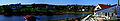
Panorama of the banks of the Hunter River in New Glasgow
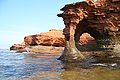
Sandstone arch


Notes
- ↑ Statistics Canada. Canada's population estimates 2008-06-25. Retrieved 2008-06-25.
- ↑ Gross domestic product, expenditure-based, by province and territory
- ↑ Statistics Canada. Canada's population estimates 2008-06-25. Retrieved 2008-06-25.
- ↑ Statistics Canada (March 2007). 2006 Census population and dwelling counts. Retrieved 2007-03-13.
- ↑ Brendan O'Grady, Exiles and Islanders: The Irish Settlers of Prince Edward Island, p. 15)
- ↑ PEI Provincial Government. Historical Milestones. Retrieved 2007-08-17.
- ↑ PEI history Government of Canada
- ↑ Statistics Canada (2002). Population of Canada's Provinces. Retrieved 2007-04-03.
- ↑ PEI population trend (Statistics Canada).
- ↑ Population urban and rural, by province and territory (Statistics Canada, 2005).
- ↑ Detailed Mother Tongue (186), Knowledge of Official Languages (5), Age Groups (17A) and Sex (3) (2006 Census)
- ↑ 12.0 12.1 PEI Potato, potato production figures.
- ↑ Idaho Potator Production
- ↑ Lobster Fishing (PEIonline)
- ↑ Island Regulatory and Appeals Commission (PEI Government).
- ↑ Government of PEI. PEI Bans the Can. Retrieved 2007-04-03.
- ↑ CBC. End to can ban receives full support of legislature. Retrieved 2007-04-27.
- ↑ Government of PEI. Government to lift "can-ban" May 3 beverage container management system encourages returns and recycling. Retrieved 2008-04-26.
- ↑ Government of PEI. Minimum Wage Order. Retrieved 2008-05-01.
- ↑ The Confederation Bridge (official website).
- ↑ Island Waste Management Corporation - Waste reduction (PEI Government).
- ↑ The Globe and Mail (December 06). Pesticides are what's killing our kids. Retrieved 2007-04-03.
ReferencesISBN links support NWE through referral fees
- Arsenault, Georges. 1989. The Island Acadians, 1720-1980. Charlottetown: Ragweed Press. ISBN 0920304818 and ISBN 9780920304815
- Baglole, Harry. 1977. Exploring island history: a guide to the historical resources of Prince Edward Island. Belfast, P.E.I.: Ragweed Press. ISBN 092030401X. and ISBN 0920304001
- Bolger, Francis W. P. 1973. Canada's smallest province: a history of P.E.I. Charlottetown: Prince Edward Island 1973 Centennial Commission.
- Beck, E. Boyde, and P. John Burden. 1996. Prince Edward Island: an (un)authorized history. Charlottetown, P.E.I.: Acorn Press. ISBN 0969860617 and ISBN 9780969860617
- Bumsted, J. M. 1987. Land, settlement, and politics on eighteenth-century Prince Edward Island. Kingston [Ont.]: McGill-Queen's University Press. ISBN 0773505660 and ISBN 9780773505667
- Clark, Andrew Hill. 1959. Three centuries and the island; a historical geography of settlement and agriculture in Prince Edward Island, Canada. [Toronto]: University of Toronto Press.
- Ives, Edward D. 1999. Drive dull care away: folksongs from Prince Edward Island. Charlottetown, P.E.I.: Institute of Island Studies. ISBN 0919013341 and ISBN 9780919013346
- Livingston, Walter Ross. 1931. Responsible government in Prince Edward Island, a triumph of self-government under the crown. Iowa City: The University. Online version. Questia. Retrieved May 11, 2008.
- MacKinnon, Wayne E. 1973. The life of the party: a history of the Liberal Party in Prince Edwards Island. s.l: s.n.].
- MacKinnon, Frank. 1995. Church politics and education in Canada: the P.E.I. experience. Calgary, Alta: Detselig Enterprises. ISBN 1550591045 and ISBN 9781550591040
- Sharpe, Errol. 1976. A people's history of Prince Edward Island. Toronto: Steel Rail Pub. ISBN 0887910033 and ISBN 9780887910036
- Smitheram, Verner, David Milne, and Satadal Dasgupta. 1982. The Garden transformed: Prince Edward Island, 1945-1980. Charlottetown: Ragweed Press. ISBN 0920304109 and ISBN 9780920304105
- Weale, David, and Harry Baglole. 1973. The Island and Confederation: the end of an era. s.l: s.n.].
External links
All links Retrieved May 11, 2008.
| |||||||||||
| ||||||||||
Credits
New World Encyclopedia writers and editors rewrote and completed the Wikipedia article in accordance with New World Encyclopedia standards. This article abides by terms of the Creative Commons CC-by-sa 3.0 License (CC-by-sa), which may be used and disseminated with proper attribution. Credit is due under the terms of this license that can reference both the New World Encyclopedia contributors and the selfless volunteer contributors of the Wikimedia Foundation. To cite this article click here for a list of acceptable citing formats.The history of earlier contributions by wikipedians is accessible to researchers here:
The history of this article since it was imported to New World Encyclopedia:
Note: Some restrictions may apply to use of individual images which are separately licensed.