Fernando de Noronha and Atol das Rocas Reserves
Mary Anglin (talk | contribs) |
Mary Anglin (talk | contribs) m (→Geography) |
||
| Line 75: | Line 75: | ||
|- | |- | ||
| valign="top"| | | valign="top"| | ||
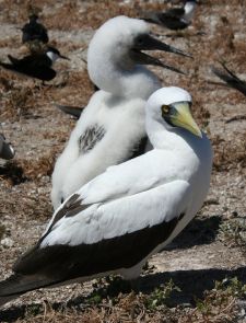
| − | [[Masked booby with chick.JPG|thumb|225px|Masked Booby with chick, a migratory species that breeds on Atol das Rocas.]] | + | [[Image:Masked booby with chick.JPG|thumb|225px|Masked Booby with chick, a migratory species that breeds on Atol das Rocas.]] |
| valign="top"| | | valign="top"| | ||
[[Image:Red-footed Booby (Sula sula) flying.jpg|thumb|225px|A Red-footed Booby in flight.]] | [[Image:Red-footed Booby (Sula sula) flying.jpg|thumb|225px|A Red-footed Booby in flight.]] | ||
Revision as of 18:29, 8 November 2008
| Brazilian Atlantic Islands: Fernando de Noronha and Atol das Rocas Reserves* | |
|---|---|
| UNESCO World Heritage Site | |
| |
| State Party | |
| Type | Natural |
| Criteria | vii, ix, x |
| Reference | 1000 |
| Region** | Latin America and the Caribbean |
| Inscription history | |
| Inscription | 2001 (25th Session) |
| * Name as inscribed on World Heritage List. ** Region as classified by UNESCO. | |
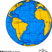
Fernando de Noronha is an archipelago in the Atlantic Ocean, part of the State of Pernambuco, around 354 km offshore from the Brazilian coast. Its area is 18.4 km², its population 2,051 (2000). The area is a special municipality (distrito estadual) of the Brazilian state of Pernambuco. Its timezone is UTC−2h. The position is .
Due to their remote location, the islands remain largely undisturbed by the human activities. The island became a national park in 1988 and, along with nearby Rocas Atoll, was designated a UNESCO World Heritage site in 2001.
History
Controversies surround the archipelago's discovery by Europeans. From its original name, Ilha da Quaresma (Lent Island), it was sighted by expeditions in the years 1501, 1502 and 1503. The Viscount of Santarém, however, attributed the discovery to Gaspar de Lemos, captain of the supply ship of Pedro Álvares Cabral's fleet, sent back to Portugal with news of the discovery of Brazil. Modern historians, however, credit the 1501-1502 expedition led by Fernão de Noronha with the discovery of the archipelago.
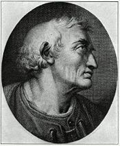
The first to actually describe the island was Amerigo Vespucci, who traveled with a Portuguese expedition of Gonçalo Coelho to Brazil in the year 1503.
In 1534, the Fernando de Noronha Archipelago was invaded by the English, and from 1556 until 1612, it was held by the French. In 1628, it was occupied by the Dutch, who were displaced two years later by a Spanish-Portuguese military expedition led by Rui Calaza Borges. The Dutch occupied the island once again in 1635, making it a hospital for their troops who occupied Northeastern Brazil (the Brazilian coast between Rio São Francisco and Maranhão). The island became known as Pavonia, in honor of Michiel de Pauw, one of the directors of the Dutch West Indies Company. It would remain under Dutch control for nearly twenty years, when it was reconquered by Portugal.
Finding it uninhabited and completely abandoned in 1736, the French East Indies Company took the island and renamed it Isle Dauphine. Only from 1737 on, after the expulsion of the French, Fernando de Noronha was definitively occupied by Portugal. This time it was decided to fortify the island. For this purpose, ten forts were built in all strategic points where a possibility of disembarkation existed; nine in the main island and one in the Ilha de São José situated in front of the Saint Anthony harbor. The forts were connected by a network of stone roads. This defense system was planned by the Portuguese military engineer Diogo da Silveira Veloso.
In approximately 1770, the first permanent settlement on the island, Vila dos Remédios, was founded. The village was divided in two units (pátios); one which consisted of the administrative buildings, and the other which contained a the church and the associated religious buildings.
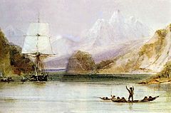
Charles Darwin’s historical five-year Beagle expedition in the 1830s included time spent on Fernando de Noronha. His observations resulted in subsequent visitations by other researchers.
When Brazil gained its independence in the late nineteenth century, little change occurred on Fernando de Noronha. At the beginning of the 20th century, the British arrived to provide technical cooperation in telegraphy (The South American Company). Later the French came with the French Cable and the Italians with Intalcable.
In 1942, during World War II, the archipelago was made a Federal Territory that also included Rocas Atoll and Saint Peter and Paul Rocks. During this time, political prisoners joined civilian detainees at the local prison, which was constructed in the late 18th century when the island began its service as a Portuguese penal colony.
From 1957-1962, the Brazilian government allowed the United States to use the island as a tracking station for guided missiles.
In 1988 approximately 70 percent of the archipelago was declared a maritime national park, with the goal of preserving the land and sea environment. On October 5, 1988, the Federal Territory was dissolved and added to the state of Pernambuco (except Rocas Atoll, which was added to the state of Rio Grande do Norte).
Fernando de Noronha's economy depends on tourism, restricted by the limitations of its delicate ecosystem. The archipelago has been the subject of the attention of various scientists dedicated to the study of its plant and animal life as well as its geology.
In 2001, UNESCO declared Fernando de Noronha, with Rocas Atoll, a World Heritage Site.
Geology
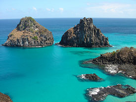
The islands of the Fernando de Noronha archipelago are the visible peaks of a range of submerged mountains. Consisting of 21 islands, islets and rocks of volcanic origin, the main island has an area of 18 square kilometers (7 sq mi), being 10 km (6.2 mi) long and 3.5 km (2 mi) at its maximum width.
The base of this enormous volcanic formation is 756 meters (2,480.3 feet) below the surface. The main island, from which the group gets its name, makes up 91 percent of the total area; the islands of Rata, Sela Gineta, Cabeluda and São Jose, together with the islets of Leão and Viúva make up the remainder.
The main island's western coastline contains cliffs with sandy beaches, extensive sand dunes occur in the east, Saco de Atalaia contains a tidal pool, and the southeast has a freshwater lake. Highly alkaline and subsatured volcanic and subvolcanic rocks are the primary make-up of the archipelago. The region's dry season runs from December through February, during which time many small springs and streams disappear.
Geography
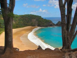
During the 19th century much of the main island of Fernando de Noronha was cleared in order to prevent prisoners from building rafts. The islands are now predominantly covered by shrublands, with some areas of secondary forest. Many of the plants currently prevalent on the island are introduced.
Such fruit trees as papaya, banana, cashew, tamarind, and guava were introduced to the archipelago. Introduced decorative species include the almond tree, jasmine mango, royal poinciana, eucalyptus, as well as coconut palm and carnauba.
The United Nations Environment Programme lists 15 possible endemic plant species, two endemic birds including the Noronha vireo, two 2 endemic reptiles, two endemic invertebrates, and a species of Gammarus, endemic in lakes and streams.
Large populations of both migratory and resident birds are found on both Fernando de Noronha Archipelago and Atol das Rocas. The largest bird breeding colonies of all islands within the Tropical South Atlantic are found in the archipelago.
Migratory species on Fernando de Noronha include the black noddy, brown noddy, sooty tern, fairy tern, red-footed booby, masked booby, and red-billed tropicbird. Atol das Rocas provides the largest breading colonies of the masked booby and brown noddy in Brazil and of sooty tern within the South Atlantic.
Brazil's second largest reproductive area for green turtles is Atol das Rocas, following Trindade Island. There are no extant indigenous mammals on Fernando de Noronha, and no mammals at all on Atol das Rocas.
The climate is tropical, with two well defined seasons: the rainy season from January to August, and the dry season for the remainder of the year.
A great abundance of commercial fish as well as lobsters surround the atoll, while a large school of dolphins reside near Fernando de Noronha. These combine with numerous tortoises, albatrosses, and a tropical climate to attract tourists. The area is one of the most popular for scuba diving place in Brazil. Warm water and exuberant subaquatic fauna and flora can be found in dives from 25 to 40 meters (80 to 130 feet) deep.
|
File:Red-footed Booby (Sula sula) flying.jpg A Red-footed Booby in flight. |
Conservation and environmental threats
EDIT
Humans have been altering these islands for many years. Most of the native forests have disappeared, and the remaining forests are threatened by wood collection for fire and construction, a growing human population, livestock grazing, and—most importantly—the introduction of exotic plants and animals. Most of the trees and plants found on the island today were originally brought by humans. Native forests have been reduced to only five percent of their original area and can be found only in isolated patches and on lesser-inhabited islands.
Rocas Atoll
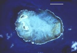
Rocas Atoll (Atol das Rocas) is an atoll in Brazil's Rio Grande do Norte state. It is located 145 km (90 mi) west of Fernando de Noronha, and approximately 232 km (144 mi) from the mainland. A wildlife sanctuary and biological reserve, it is uninhabited and used solely for scientific research. Along with the Fernando de Noronha archipelago, Rocas Atoll was designated a UNESCO World Heritage Site in 2001.
Of volcanic origin and coralline formation, the oval atoll is 3.7 km (2.3 miles) long and 2.5 km (1.6 miles) wide. The lagoon is up to 6 m (20 ft) deep and has an area of 7.1 km² (2.7 sq mi). The land area of the two islets (Cemitério Island, southwest and Farol Cay, northwest) is 0.36 km² (89 acres). Farol Cay accounts for almost two thirds of the aggregate area. The highest point is a sand dune in the south of larger Farol Cay, with a height of 6 m (20 ft). The atoll consists mainly of coral and red algae. The coral ring is nearly completely closed, with a 200 m (660 ft) wide channel on the north side and a much narrower channel on the west side.
Both islets are overgrown with grasses, bushes and a few palm trees. There are crabs, spiders, scorpions, sand fleas, beetles, large roaches, and many species of birds. Numerous turtles, sharks, and dolphins also make their home in the area.
There is a lighthouse of the Brazilian coast guard that has been in operation and maintained since the 1960s at the Northern end of Farol Cay. In its vicinity is a derelict lighthouse from 1933.
Some title
EDIT
http://www.worldwildlife.org/wildworld/profiles/terrestrial/nt/nt0123_full.html
Fernando de Noronha Marine National Park, covering 112.7 km2 of the archipelago, was established in 1988. Despite the serious loss of habitat that occurred when the island was cleared of trees, many protective measures have been established, allowing the habitat of the archipelago to recover and persist. The offshore islets are relatively undisturbed. The archipelago has a stable human population of less than 3,000 inhabitants, concentrated on the principal island, and a small transient population of tourists and researchers (Almeida 2000). With its interesting landscape, pleasant climate, and morning visitations by the resident dolphins, Fernando de Noronha Island is considered by many as Brazil’s most beautiful island. Tourism began in the 1970’s, and currently there are daily flights to the island from Natal and Recife. However, the total number of tourists on the island is subjected to limits, and visitors must pay a daily "environment" tax, which increases incrementally as the visit progresses. There is little tourism infrastructure. The sole hotel was adapted from the North-American Airforce base in operation during the World War II, a few guest houses operate near Remédios Village on the eastern end of the island, and there is only one paved, seven-kilometer road (Almeida 2000). In addition to the limitations imposed on tourism, two research organizations, the Instituto Brasileiro do Meio Ambiente e dos Recursos Naturais Renováveis (IBAMA), of the Rotator Dolphins Project, and the Tamar Project (a marine turtle nesting project) are involved in monitoring ecological impact on the archipelago (Almeida 2000).
Resources
- Darwin, Charles, W. Botting Hemsley, Henry Nicholas Ridley, and Linn M. Smith. 1994. Charles Darwin visits Fernando Noronha: an illustrated narrative of one day during the voyage of H.M.S. "Beagle" with particular emphasis on the plants collected : based on his diary, journal, plant notes, and herbarium specimens. Northampton, Massachusetts: Old Leaf Press.
- de Almeida, C. E., V. Marchon-Silva, R. Ribeiro, A. Serpa-Filho, J. R. de Almeida, and J. Costa. 2000. "Entomological Fauna from Reserva Biologica do Atol das Rocas, Rn, Brazil: I. Morphospecies Composition". REVISTA BRASILEIRA DE BIOLOGIA. 60: 291-298.
- National Geographic Society. Fernanda de Noronha-Atol das Rocas moist forests (NT0123) Retrieved November 7, 2008.
- Pousada do Frances. Fernando de Noronha - Brazil Retrieved November 7, 2008.
- Secchin, Carlos, and Clóvis Barreira e Castro. 1987. Arquipélago de Fernando de Noronha. Rio de Janeiro, RJ, Brasil: Cor/Ação. ISBN 9788585058036
- World Wildlife Fund. 2001. Fernando de Noronha-Atol das Rocas moist forests (NT0123) Retrieved November 7, 2008.
External links
All Links Retrieved November 7, 2008.
- Audio interview with Fernando de Noronha resident about life on Fernando de Noronha
- Site about islands in Brazil
- A photo tour of the island
- Photos of Fernando de Noronha by Alex Uchoa
- Administration of Pernambuco
- Tourist site in Spanish
Atlantic Forest South-East Reserves · Brasília · Central Amazon Conservation Complex · Chapada dos Veadeiros and Emas · Diamantina · Discovery Coast Atlantic Forest Reserves · Fernando de Noronha and Atol das Rocas · Goiás · Iguaçu · Olinda · Ouro Preto · Pantanal Conservation Area · Salvador de Bahia · Sanctuary of Bom Jesus do Congonhas · São Luís · Serra da Capivara
Shared with Argentina:Ruins of São Miguel das Missões (Jesuit Missions of the Guaranis)
| |||||||||||||||||||
Coordinates:
Credits
New World Encyclopedia writers and editors rewrote and completed the Wikipedia article in accordance with New World Encyclopedia standards. This article abides by terms of the Creative Commons CC-by-sa 3.0 License (CC-by-sa), which may be used and disseminated with proper attribution. Credit is due under the terms of this license that can reference both the New World Encyclopedia contributors and the selfless volunteer contributors of the Wikimedia Foundation. To cite this article click here for a list of acceptable citing formats.The history of earlier contributions by wikipedians is accessible to researchers here:
The history of this article since it was imported to New World Encyclopedia:
Note: Some restrictions may apply to use of individual images which are separately licensed.
