Bratislava
| Bratislava | |||
|---|---|---|---|

| |||
| Region (kraj) | Bratislava Region | ||
| District (okres) | Bratislava I-V | ||
| Location | coord}}{{#coordinates:48|08|41|N|17|06|46|E|type:city_scale:30000 | name=
}} | |
| Altitude | 126-514 m | ||
| Population | 446,819 (as of 2005) | ||
| Area | 367.59 km² | ||
| Time Zone • Summer DST |
CET: UTC+1 CEST: UTC+2 | ||
| Telephone prefix | +421-2 | ||
| Postal code | 8XXXX | ||
| Car registration plate | BA | ||

| |||
Bratislava (see below for other names) is the capital of Slovakia and the country's largest city, with a population of some 450,000. Bratislava is the political, cultural and economic centre of Slovakia. It is the seat of the Slovak presidency, parliament and government as well as home to several universities, museums, theatres, galleries and other national economic, cultural and educational institutions. Most of Slovakia's large businesses and financial institutions have their headquarters in Bratislava. The city's past has been characterized by the strong influence of various peoples, including Slovaks, Germans, Hungarians, Czechs, Austrians and Jews. Bratislava still retains its cosmopolitan spirit. It hosts many festivals and trade shows and it is famous for its night life and leisure facilities.
Etymology
In March 1919 Bratislava was adopted as the official name. It is not known on what grounds. One theory is that the name was invented by US president Wilson, another that it might be a corruption of the old Slavic Braslava. However, we know for sure that a variant of this name was reconstructed by Pavel Jozef Šafárik (by mistake) from old names in the 1830s based on the name of the Bohemian ruler Bretislav. It was used subsequently by members of the Slovak movement in the 1840s and occasionally also afterwards.
A more detailed list can be found in the History of Bratislava article.
| Bratislava's names most commonly used before 1920 | ||
|---|---|---|
| Preßburg | German (before the 19th century occasionally and since the German spelling reform of 1996 regularly spelled Pressburg) | |
| Prešporok | Slovak name; stems from the German one (one of the many variants was Pressporek in 1773) | |
| Prešpur(e)k or Presspur(e)k | Czech | |
| Pressburg(h) or Pressborough | English (Pressburg Street in southwestern London) | |
| Presburgo | Spanish | |
| Pressbourg later Presbourg | French (rue de Presbourg in Paris) | |
| Presburg | Dutch | |
| Pozsony | Hungarian (still in use by Hungarians today). Earlier variant Posony (1773) | |
| Posonium | Latin | |
| Požun | Croatian, Serbian, Bosnian | |
| Pozhoma | Romani | |
| Istropolis | Greek, meaning the Danube City | |
Geography
Bratislava lies on both banks of the River Danube, by Slovakia's borders with Austria and Hungary, and is only an hour's drive from the border with the Czech Republic. It is the only capital in the world which borders two countries. The Carpathian mountain range begins within the territory of the city with the Little Carpathians (Slovak: Malé Karpaty).
Bratislava is only 50 km from the Austrian capital Vienna.
Other rivers include Morava River, which forms north-western border of the city, and the Little Danube.
The closest towns or villages are to the north Stupava, Marianka, Borinka and Svätý Jur, to the east Ivanka pri Dunaji and Most pri Bratislave, to the south-east Rovinka, Hamuliakovo, Dunajská Lužná and Šamorín, to the south Rajka(H), and to the west Kittsee(A), Hainburg an der Donau(A) and Marchegg (A).
Climate: The city climate is mild. It is often windy with a marked variation between hot summers and cold, humid winters.
- annual average temperature: 9.9 °C
- annual sunshine hours: 1976.4 (5.4 hours/day)
- annual average rainfall: 527.4 mm (according to 1993 data)
History
main article: History of Bratislava
Prehistory and early Middle Ages
- Neolithic Age: the first permanent settlement of the region now known as Bratislava begins with the Linear Pottery Culture
- 400 B.C.E.-50 B.C.E.: Celts were settled here. From 125 B.C.E. they had an important oppidum (fortified town) with a mint here.
- 1st century – 5th century: the border of the Roman Empire (Limes Romanus) runs right through the middle of today's town; many Roman (e.g. "Gerulata") and Germanic settlements
- 6th century-8th century: first Slavs (500 C.E.- today) and Avarians (560s - 8th century)
- - 623-658: part of King Samo's Empire
- late 8th century – 833: part of the Principality of Nitra
- 833 – 907: part of Great Moravia
907-1918

- From 2nd half of 10th century to 1918: part of the Kingdom of Hungary (with short interruptions) and the capital of the Posonium Comitatus:
- 1536-1784: capital of the Kingdom of Hungary (whose territory consisted until 1699 of today's Slovakia and parts of today's Western Hungary, because the Turks ruled Buda at that time); the Kingdom of Hungary was part of the Habsburg (i. e. Austrian) Monarchy from 1526 to 1918
- 1542-1848: meeting place of the Hungarian Diet (with short interruptions)
- 1563-1830: coronation town for Hungarian kings (St. Martin's Cathedral (picture below))
- since the 18th century: centre of the Slovak national movement
Post WWI (1919-present)
- 1919-1939: part of Czechoslovakia; official new name becomes "Bratislava"- instead of "Prešporok" (Slovak) /"Pressburg" (German)/ "Pozsony" (Hungarian) in 1919
- 1939-1945: capital of Slovakia
- 1945-1992: part of Czechoslovakia again:
- 1969-1992: capital of the federal state of Slovakia within Czechoslovakia
- since 1993: capital of Slovakia
Important events held in Bratislava
Culture and points of interest
Theatres

Bratislava is the seat of Slovak National Theatre, which until April 2007 is housed in 3 buildings in the city centre, when it will move to the new building near the Danube. Smaller and alternative theatres include: Bratislava Puppet Theatre, Astorka Korzo '90 theatre, Aréna theatre, etc.
Museums
Main museums:
- Slovak National Museum is located near the Nový Most near the Danube [1].
- Municipal Museum of Bratislava focuses on the history of Bratislava (established 1868) [2]
Other museums:
- Museum of Transportation is located near the main railway station
- Museum of Weapons is in the Michael's Gate
- Museum of Modern Art in the Čunovo city part
Science
Slovak Academy of Sciences has its seat in Bratislava. The town is one of the few European capitals that does not have either an observatory or a planetarium. The closest observatory is in Modra (30 km away from Bratislava), and planetarium in Hlohovec (70 km away).
Music
Seat of the Slovak Philharmonic Orchestra.
Landmarks

Bratislava is picturesquely situated on both banks of the Danube, at the base of the outlying spurs of the Lesser Carpathians, in a position of strategic importance near the Devín Gate (earlier called Hainburger Pforte or Porta Hungarica). The area includes a picturesque old town centre.
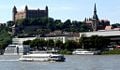
One of the most conspicuous buildings of the town is the Bratislava Castle situated on a plateau 82 m above the Danube. A castle has existed on the site since time immemorial. It has been the acropolis of a Celtic town, part of the Roman Limes Romanus, a huge Slav fortified settlement and a political, military and religious centre of Great Moravia. A castle of stone was built only in the 10th century (part of Hungary), it was turned into a Gothic anti-Hussite fortress under Sigismund of Luxemburg in 1430, in 1562 it became a Renaissance castle, and in 1649 a baroque reconstruction took place. Under Queen Maria Theresa, the castle was turned into a prestige seat of the royal governor Albert von Sachsen-Teschen, the son-in-law of Maria Theresa, who founded the Albertina picture gallery in the castle, which was later moved to Vienna. In 1784, when Bratislava ceased to be the capital of Hungary, the castle was turned into a school for Catholic clergy, and later, in 1802, into barracks. In 1811, the castle was inadvertently destroyed by fire by the French soldiers and lay in ruins until the 1950s, when it was reconstructed mostly in its former Maria Theresa style.
Another castle is Devín Castle (now in ruins) in the borough of Bratislava-Devín. It is situated on the top of a high rock at the point where the March (Morava) river, which forms the boundary between Austria and Slovakia, reaches the Danube. It is one of the most important Slovak archaeological sites and has been – thanks to its excellent location – a very important frontier castle of Great Moravia and the early Hungarian state. It was destroyed by Napoleonic troops in 1809 and is an important symbol of Slovak and Slavic history.
Yet another castle, built in 1813 and turned into an English Gothic style castle in the late 19th century, is situated in the borough of Bratislava-Rusovce, otherwise known for ruins of Roman Gerulata settlements.

Other noteworthy buildings are:
.jpg)
- St. Martin's Cathedral (a Gothic edifice of the 14th-15th century replacing an older church from the 13th century) in which many of the Hungarian kings were crowned
- Bratislava's Town hall (a complex of 14th-15th century buildings) containing an interesting museum – the City Museum founded in 1868
- Bratislava's Franciscan church, dating from 1297
- the building of the University Library (erected in 1756) where the sittings of the Diet (parliament) of the Kingdom of Hungary were held from 1802 to 1848 and many important laws of the Hungarian Reform Era were enacted (liberation of serfs, foundation of the Hungarian Academy of Sciences).
- the Primate's Palace (erected in 1781) in which the (4th) Peace of Pressburg was signed
- the beautiful Slovak National Theatre (built in 1886), and
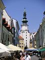
- the Michael's Gate (early 17th century), the only extant gate of the municipal fortification
- the narrowest house in central (or maybe in the whole of) Europe (just behind the Michael's Gate)
- the 18th century house of the composer Johann Nepomuk Hummel who was born in the town.
- Nový Most Bratislava is a bridge across the Danube river, featuring a UFO-like tower restaurant
- Kamzik TV Tower is a TV tower of unique design with an observation deck
- Seat of the Slovak Radio - an inverted pyramid.
The historic centre is characterized by many baroque palaces. The Grassalkovich Palace (built around 1760), for example, is now the residence of the Slovak president, and the Slovak government now has its seat in the former Archiepiscopal palace, the former summer residence of the archbishop of Esztergom).
A curiosity is the underground restored portion of the Jewish cemetery where Rabbi Moses Sofer is buried. (See article on Sofer).

The only military cemetery and known memorial is Slavín, which was revealed in 1960, in the honour of Soviet Army soldiers, who fell when liberating Bratislava from the Nazi German troops. It also offers an excellent view of the city and the Little Carpathians.
Squares
The most known square in Bratislava is the Main Square. It was completely reconstructed in 2005. The Hviezdoslav and Primatial's squares are nearby. There is also square of Slovak National Uprising in the town centre, near the main shopping street.
Lakes
The city has a number of natural or man-made lakes, most of which are also used for recreation.
Examples include Štrkovec lake, Kuchajda in Ružinov, the Vajnory lakes, Zlaté Piesky in the north-east and Malý Dráždiak, Veľký Dráždiak in Petržalka.
Parks
Bratislava is a city with lots of parks, thanks to its location on the foothills of the Little Carpathians. The biggest of those parks is the Bratislava forest park, which includes some tourist locations, for example Železná studienka or Koliba. Horský park (literally Mountain(ous) Park) is located near the Old Town and it's still with original flora and fauna. On the right bank of the Danube is Sad Janka Kráľa, the first public park in Europe.
Bratislava's zoological park is located at Mlynská dolina, close to the headquarters of the Slovak Television.
Sport
Football
Currently 3 teams from Bratislava are playing the Corgoň Liga:
- Š.K. Slovan Bratislava Official website
- FC Artmedia Bratislava Official website
- FK Inter Bratislava Official website
Ice hockey
One team from Bratislava plays the Slovak Extraliga: HC Slovan Bratislava Official website
Entertainment
Bratislava is known as a city with pulsing nightlife. Most of the bars and night clubs are located in the city centre.
| Demographics | ||
|---|---|---|
| data derived from the 2001 census | ||
| Population | 428,672 inhabitants | |
| Population by districts | Bratislava I 44,798, Bratislava II 108,139, Bratislava III 61,418, Bratislava IV 93,058, Bratislava V 121,259 | |
| Average age | 38.7 years | |
| Age structure | 0–5: 4.1%, 6–14: 9.8%, Working age: 62.9%, Retirement age: 19% | |
| Ethnic groups | Slovaks 391,761 (91.4%), Hungarians 16,451 (3.8%), Czechs 7,972 (1.9%), Moravians 635, Ruthenes 461, Ukrainians 452, Germans 1 200, Croats 614, Roma 417, Poles 339 | |
| Religion | Roman Catholics 243,048 (56.7%), Atheists 125,729 (29.3%), Lutherans of the Augsburg Confession 24,810 (6%), Greek Catholics 3,163 (0.7%), Reformed Christians 1,918, Eastern Orthodox 1,616, Jehovah's Witnesses 1,827, Methodist Protestants 737, Jews 700, Baptists 613 | |
Tourism
In the recent years, particularly after Slovakia's entry to the European Union, Bratislava is target for the tourists from surrounding, as well as from more distant countries (Britain, United States, Japan, ...). But the growth of tourism has brought problem with insufficient hotel capacity, especially from more luxurious ones. Most tourists are staying in the city centre, or they are coming for annual event such as for celebrations of New Year.
Education
The first university in Bratislava and also in Slovakia was the Academia Istropolitana, established in 1467.
Today, it is the seat of several colleges/universities:
- Academy of Performing Arts
- Bratislava Technical College
- Comenius University
- Slovak University of Technology
- University of Economics
- Academy of Fine Arts and Design
Economy
The economy of Bratislava is prosperous and mainly based on :
- services
- engineering (Volkswagen)
- chemical (Slovnaft) and electrical industry
The GDP per capita (PPP), which was valued at €25,351 (2002), reaches 120% of the EU average, which is the second highest level (after Prague) of all regions in all the recently joined countries (Eurostat; for the latest Eurostat data, see: [3]) Bratislava has the all-time lowest unemployment in Slovakia (around 3%), and many people from Slovakia are commuting to Bratislava for work.
In recent years service and high-tech oriented businesses are thriving in Bratislava. Many global companies, including IBM, Dell, Accenture, AT&T, Lenovo and SAP to name a few, are building their outsourcing and service centres here.
Transport
Geographical position in Central Europe has always made Bratislava a natural crossroads for international trade traffic.
Road transportation

Large international motorway junction: D1 motorway connecting Bratislava to Trnava, Nitra, Trenčín, Žilina and further, while D2 motorway connecting it to Prague, Brno and Budapest in the north-south direction. D4 motorway (the outer bypass) is mostly at planning stage.
The A6 motorway to Vienna is currently under construction and will be open in November 2007.
Currently five bridges stand over the Danube:(ordered by the flow of river):Lafranconi Bridge, Nový Most, Starý Most, Most Apollo and Prístavný most.
Rail transportation
The most important is the main railway station at the edge of Old Town with lines connecting it to Košice through northern Slovakia, Czech Republic, Austria, Hungary and southern Slovakia. Another important station is the Petržalka railway station, which is important especially for lines from Austria. There are also many suburb stations, for example in Rača, Lamač, Čunovo and so on.
Air transportation
Bratislava has the largest international airport in Slovakia, which enjoys rapidly growing traffic in recent years, and in conjunction with the Vienna International Airport, which is located some 40 km away, is providing a large international network.
River transportation
Bratislava has one of two international Slovak river ports (see Port of Bratislava), as well as numerous tourist lines along the Danube.
Public transportation
Public transportation in Bratislava is run by Dopravný podnik Bratislava, the city-owned company. There are three types of transport vehicles used in Bratislava including buses (covering the most of the city and the largest district of Petržalka), trams (covering the most frequent commuter trips and connecting city centre with suburbs) and trolleybuses (connecting the city centre with suburbs and serving as a complementary mean of transport).
Territorial division
Bratislava is divided to:
5 districts (national administrative division):
- Bratislava I: Covers the city centre
- Bratislava II: Covers the south-eastern and eastern parts
- Bratislava III: Covers the north-eastern parts
- Bratislava IV: Covers the western, north-western and northern parts
- Bratislava V: Covers the southern parts
17 "city parts" (i.e. approx. boroughs) (for the purpose of municipal administrative division and of serving as entities to which the town delegates its powers and functions imposed by law on communities)
20 "cadastral areas" they coincide with the "city parts",
- except:
- Nové Mesto is further split into Nové Mesto + Vinohrady
- Ružinov is split into : Ružinov + Nivy + Trnávka
| Administrative and Territorial Division of Bratislava | ||
|---|---|---|
| Districts | "City Parts" (Boroughs) | Quarters or Localities |
| Bratislava I | Staré Mesto | |
| Bratislava II | Ružinov | Nivy, Pošeň, Prievoz, Ostredky, Trávniky, Štrkovec, Vlčie hrdlo, Trnávka |
| Vrakuňa | Dolné hony | |
| Podunajské Biskupice | Dolné hony, Ketelec, Lieskovec, Medzi jarkami | |
| Bratislava III | Nové Mesto | Ahoj, Jurajov dvor, Koliba, Kramáre, Mierová kolónia, Pasienky/Kuchajda , Vinohrady |
| Rača | Krasňany, Rača, Východné | |
| Vajnory | ||
| Bratislava IV | Karlova Ves | Dlhé diely, Kútiky, Mlynská dolina, Rovnice |
| Dúbravka | Podvornice, Záluhy, Krčace | |
| Lamač | Podháj, Rázsochy | |
| Devín | ||
| Devínska Nová Ves | Devínske Jazero, Kostolné, Paulinské, Podhorské, Stred, Vápenka | |
| Záhorská Bystrica | ||
| Bratislava V | Petržalka | Dvory, Háje, Janíkov dvor, Lúky, Ovsište, Kopčany, Zrkadlový háj, Kapitulský dvor, Starý háj |
| Jarovce | ||
| Rusovce | ||
| Čunovo | ||
Twin towns
Bratislava is twinned with:
 Yerevan, Armenia
 Vienna, Austria
 Ruse, Bulgaria
 Larnaka, Cyprus
 Prague, Czech Republic
 Alexandria, Egypt
 Turku, Finland
 Bremen, Germany
- Ulm, Germany
 Thessaloniki, Greece
 Székesfehérvár, Hungary
 Perugia, Italy
 Rotterdam, Netherlands
 Kraków, Poland
 Ljubljana, Slovenia
 Kiev, Ukraine
 Cleveland, USA
Images

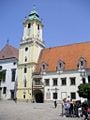
The Old Town Hall viewed from the Main Square.
- Theben.jpg
Devín Castle at the confluence of the Danube and the Morava viewed from Austria - an old picture.
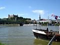
Bratislava on the river Danube
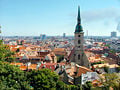
Old Town (Staré mesto) of Bratislava viewed from Bratislava Castle.
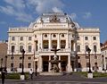
Slovak National Theatre.
Bratislava on the river Danube
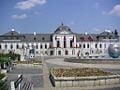
The Grassalkovich Palace - the seat of the President.
Michael's Gate.
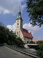
St. Martin's Cathedral - the coronation cathedral.

Apartment blocks of Petržalka, across the Danube and the Nový Most
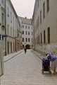
A typical paved street in Bratislava's Old Town district

Bratislava's Old Town district
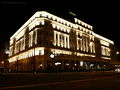
Hotel Carlton in Hviezdoslav Square (Hviezdoslavovo námestie)


See also
- Bratislava county
External links
City Information
- Official website of the City of Bratislava
- Travel guide to Bratislava from Wikitravel
- Travel guide to Bratislava
- Accommodation in Bratislava
- Guide to Bratislava
- Bratislava, Slovakia - city districts
- Bratislava information, history, tips
Public Transport
Maps
Photographs
Template:Bratislava Region

Countries: Germany · Austria · Slovakia · Hungary · Croatia · Serbia · Romania · Bulgaria · Ukraine · Moldova
Cities: Donaueschingen · Ulm · Ingolstadt · Regensburg · Passau · Linz · Vienna · Bratislava · Győr · Esztergom · Budapest · Baja · Vukovar · Ilok · Bačka Palanka · Novi Sad · Belgrade · Smederevo · Drobeta-Turnu Severin · Vidin · Rousse · Brăila · Galaţi · Tulcea
Tributaries (list): Iller · Lech · Regen · Isar · Inn · Morava · Drava · Tisza · Sava · Timiş · Velika Morava · Jiu · Iskar · Olt · Osam · Yantra · Vedea · Argeş · Ialomiţa · Siret · Prut
Credits
New World Encyclopedia writers and editors rewrote and completed the Wikipedia article in accordance with New World Encyclopedia standards. This article abides by terms of the Creative Commons CC-by-sa 3.0 License (CC-by-sa), which may be used and disseminated with proper attribution. Credit is due under the terms of this license that can reference both the New World Encyclopedia contributors and the selfless volunteer contributors of the Wikimedia Foundation. To cite this article click here for a list of acceptable citing formats.The history of earlier contributions by wikipedians is accessible to researchers here:
The history of this article since it was imported to New World Encyclopedia:
Note: Some restrictions may apply to use of individual images which are separately licensed.