Afar Depression

The Afar Depression (also called the Danakil Depression or the Afar Triangle) is a geological depression in the Horn of Africa, where it overlaps Eritrea, the Afar Region of Ethiopia, and Djibouti. Afar is well known as one of the cradles of hominids, containing the Middle Awash, site of many fossil hominid discoveries; Gona, site of the world's oldest stone tools; and Hadar, site of Lucy, the fossilized specimen of Australopithecus afarensis.
The Afar Depression includes the Danakil Desert and the lowest point in Africa, Lake Asal (–155 meters or –500 ft). Dallol is also part of the Depression, one of the hottest places year-round anywhere on Earth. The climate varies from around 25 °C (77 °F) during the rainy season (September–March) to 48 °C (118 °F) during the dry season (March–September). Only the Awash River flows into the depression, where it ends in a chain of lakes that increase in salinity.
Environment
Geographical features within the Depression include the Danakil Desert, which lies northeastern Ethiopia and in southern Eritrea and much of Djibouti. The Danakil's main industry is salt mining, while it is also home to wildlife, including African wild asses.
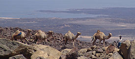
The desert is the homeland of the Afar people, the majority of whom have remained nomadic pastoralists, raising goats, sheep, and cattle in the desert. During the dry season, most move to and camp on the banks of the Awash River.Camels comprise the most common means of transportation as the Afar nomads move from watering hole to watering hole. With the arrival of the rainy season in November, most relocate to higher ground in order to avoid both flooding and mosquitos.
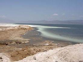
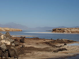
Lake Assal is a crater lake in central Djibouti, located at the southern border of Tadjoura Region, touching Dikhil Region, some 120 km (75 mi) west of Djibouti city. It lies 155 m (515 ft) below sea level; its shores comprise the lowest point on land in Africa.
Lake Assal is one of the most saline bodies of water on the earth, with a 34.8 percent salt concentration (up to 40% at 20 m (66 ft) depth). The sources of the lake are hot springs whose salinity is close to sea water, which are fed by the Gulf of Tadjoura, the eastern extension of the Gulf of Aden, specifically the nearly closed-off bay Ghoubet Kharab, about 10 km southeast of the lake.
The area is wild and desert-like, and no fauna or flora can be seen in the syrupy waters of the lake. The high temperature of the water (33-34 °C) favors evaporation, and it is surrounded by a salt pan which extends west and mainly northwest. The salt is mined and transported by caravan to Ethiopia.
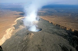
The settlement of Dallol in northern Ethiopia holds the record high average temperature for an inhabited location on Earth, where an average annual temperature of 34°C (94°F) was recorded between the years 1960 and 1966. Dallol is also one of the most remote places on Earth. There are no roads; the only regular transport service is provided by camel caravans which travel to the area to collect salt. Nearby is the Dallol volcano, which last exploded in 1926.
The Awash River, contained completely within the boundaries of Ethiopia, is the only river that flows into the Depression. It is the principal stream of an endorheic drainage basin covering parts of the Amhara, Oromia and Somali Regions, as well as the southern half of the Afar Region.
The Middle Awash is an archaeological site along the Awash River. A number of Pleistocene and late Miocene hominid remains have been found at the site, along with some of the oldest known Olduwan stone artifacts and patches of fire-baked clay. The Middle Awash contains the site of Hadar, where Australopithecus afarensis, including the famous "Lucy" partial skeleton and the "First Family" were discovered.
The lowlands of the Afar Depression are dominated by heat and drought. There is no rain for most of the year, and yearly rainfall averages range from 100 to 200 millimetres (4 to 7 in), with less rain falling closer to the coast. The Awash River, flowing northeastward through southern Afar, provides a narrow green belt and enables life for the flora and fauna in the area and for the Afars, the nomadic people living in the Danakil desert.
About 128 kilometers (79 miles) from the Red Sea, the Awash ends in a chain of salt lakes, where its water evaporates as quickly as it is supplied. About 1200 km² (463 sq mi) of the Afar Depression is covered by salt, and salt mining is still a major source of income for many Afar tribes.
Plant and animal life
The Afar Depression biome is characterized as desert scrubland. Vegetation is mostly confined to drought-resistant plants such as small trees like species of the dragon tree, shrubs, and grasses.
Wildlife includes many herbivores such as Grevy's Zebra, Soemmering’s Gazelle, Oryx Beisa and, notably, the last viable population of African wild ass (Equus africanus somalicus). Birds include the ostrich, the endemic Archer's lark (Heteromirafra archeri), the Secretary Bird, Arabian and Kori bustards, Abyssinian Roller and Crested Francolin.
In the southern part of the plain, in Ethiopia, lies the Mille-Sardo Wildlife Reserve, which was established 1973.
Many fossils have been found in the Awash region, not only hominids but also elephantoids, crocodiles and hippopotamus.
Notes
ReferencesISBN links support NWE through referral fees
- Beyene, A., and M. G. Abdelsalam. 2005. "Tectonics of the Afar Depression: A review and synthesis". JOURNAL OF AFRICAN EARTH SCIENCES. 41 (1-2): 41-59. OCLC 206729841
- Bojanowski, Axel. March 15, 2006. Africa's New Ocean: A Continent Splits Apart Spiegel Online. Retrieved January 7, 2009.
- Kloos, Helmut. 1982. "Development, drought and famine in the Awash valley of Ethiopia". African Studies Review. 25 (4): 21-48.
- Magin, Chris and Christine Burdette. 2001. Ethiopian xeric grasslands and shrublands (AT1305) World Wildlife Fund. Retrieved January 7, 2009.
External links
All Links Retrieved January 7, 2009.
- Photos of Erta Ale
- Hotsprings at Dallol
- The Ethiopian state of Afar: Topography and Climate
- (French) Photos of Afar Depression: between Ethiopia and Djibouti
Coordinates:
Credits
New World Encyclopedia writers and editors rewrote and completed the Wikipedia article in accordance with New World Encyclopedia standards. This article abides by terms of the Creative Commons CC-by-sa 3.0 License (CC-by-sa), which may be used and disseminated with proper attribution. Credit is due under the terms of this license that can reference both the New World Encyclopedia contributors and the selfless volunteer contributors of the Wikimedia Foundation. To cite this article click here for a list of acceptable citing formats.The history of earlier contributions by wikipedians is accessible to researchers here:
- Afar_Depression history
- Afar_people history
- Danakil_Desert history
- Lake_Assal_(Djibouti) history
- Dallol,_Ethiopia history
The history of this article since it was imported to New World Encyclopedia:
Note: Some restrictions may apply to use of individual images which are separately licensed.


