Difference between revisions of "Sonoran Desert" - New World Encyclopedia
Mary Anglin (talk | contribs) m |
(→External links: formated) |
||
| Line 111: | Line 111: | ||
* Edmund C. Jaeger, ''The North American Deserts'' (Stanford University Press, 1957), pp. 73-83 | * Edmund C. Jaeger, ''The North American Deserts'' (Stanford University Press, 1957), pp. 73-83 | ||
*The Pimeria Alta : missions & more, Tucson, Ariz. : Southwestern Mission Research Center, 1996. | *The Pimeria Alta : missions & more, Tucson, Ariz. : Southwestern Mission Research Center, 1996. | ||
| − | *Buford L. Pickens, [http://www.uapress.arizona.edu/BOOKS/bid356.htm The Missions of Northern Sonora, A 1935 Field Documentation], Tucson, University of Arizona Press, 1993 reprint | + | *Buford L. Pickens, [http://www.uapress.arizona.edu/BOOKS/bid356.htm The Missions of Northern Sonora, A 1935 Field Documentation], Tucson, University of Arizona Press, 1993 reprint. Retrieved May 19, 2007. |
==External links== | ==External links== | ||
| Line 119: | Line 119: | ||
* October 18, 2002. [http://alic.arid.arizona.edu/sonoran/documents/mcginnies/mcginniesmap.html Map of the Sonoran Desert]. ''Sonoran Desert''. Retrieved April 28, 2007. | * October 18, 2002. [http://alic.arid.arizona.edu/sonoran/documents/mcginnies/mcginniesmap.html Map of the Sonoran Desert]. ''Sonoran Desert''. Retrieved April 28, 2007. | ||
* [http://www.cas.vanderbilt.edu/bioimages/ecoregions/51310frame.htm Sonoran Desert]. ''Bio Images''. Retrieved April 28, 2007. | * [http://www.cas.vanderbilt.edu/bioimages/ecoregions/51310frame.htm Sonoran Desert]. ''Bio Images''. Retrieved April 28, 2007. | ||
| − | *[http://www.britannica.com/eb/article-9078145/Yuma-Desert Britannica.com] | + | * [http://www.britannica.com/eb/article-9078145/Yuma-Desert Britannica.com Yuma Desert]. ''Encyclopedia Britannica''. Retrieved May 19, 2007. |
| − | * [http://www.nps.gov/tuma/Kino_Missions.html Kino Missions] | + | * [http://www.nps.gov/tuma/Kino_Missions.html Kino Missions]. ''National Park Service''. Retrieved May 19, 2007. |
| − | * [http://parentseyes.arizona.edu/missions/ | + | * [http://parentseyes.arizona.edu/missions/ Kino Missions]. ''Mission Churches of the Sonoran Desert''. Retrieved May 19, 2007. |
| − | *[http://query.nytimes.com/gst/fullpage.html?res=9B00E7DF103CF93BA15752C0A9679C8B63&sec=travel&pagewanted=print In the Footsteps of a Bold Priest] | + | * Winckler, Suzanne. January 28, 2001. [http://query.nytimes.com/gst/fullpage.html?res=9B00E7DF103CF93BA15752C0A9679C8B63&sec=travel&pagewanted=print In the Footsteps of a Bold Priest]. ''New York Times''. Retrieved May 19, 2007. |
| − | * [http://parentseyes.arizona.edu/missions/bibl.html Bibliography, Kino Missions] | + | * [http://parentseyes.arizona.edu/missions/bibl.html Bibliography, Kino Missions]. ''Mission Churches of the Sonoran Desert''. Retrieved May 19, 2007. |
Revision as of 04:22, 19 May 2007
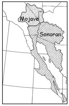
The Sonoran Desert (sometimes called the Gila Desert after the Gila River or the Low Desert in opposition to the higher Mojave Desert) is a North American desert which straddles part of the United States-Mexico border and covers large parts of the U.S. states of Arizona and California and the Mexican state of Sonora. It is one of the largest and hottest deserts in North America, with an area of 120,000 square miles (311,000 km²). The desert contains a variety of unique plants and animals, such as the saguaro cactus. On January 17, 2001, 496,337 acres (2,008 km²) of the Sonoran Desert was set aside as the Sonoran Desert National Monument for the purpose of enhancing resource protection.
The Sonoran Desert wraps around the northern end of the Gulf of California, from northeastern Baja California through southeastern California and southwestern Arizona to western Sonora. It is bounded on the west by the Peninsular Ranges, which separate it from the California chaparral and woodlands and Baja California desert ecoregions of the Pacific slope. To the north, the Sonoran Desert transitions to the cold-winter Mojave, Great Basin, and Colorado Plateau deserts. To the east, the deserts transition to the coniferous Arizona Mountains forests and Sierra Madre Occidental forests at higher elevations. The Sonoran-Sinaloan transition subtropical dry forest marks the transition from the Sonoran Desert to the tropical dry forests of Sinaloa.
The desert's subregions include the Colorado Desert and Yuma Desert. In the 1951 publication, Vegetation of the Sonoran Desert, Forrest Shreve divided the Sonoran Desert into seven regions according to characteristic vegetation: Lower Colorado Valley, Arizona Upland, Plains of Sonora, Foothills of Sonora, Central Gulf Coast, Vizcaino Region, and Magdalena Region. (see An Overview of the Sonoran Desert, external link below). Many ecologists now consider Shreve's Vizcaino and Magdalena regions, which lie on the western side of the Baja California Peninsula, to be a separate ecoregion, the Baja California desert.
Ecology of the Sonoran Desert
The Sonoran Desert includes 60 mammal species, 350 bird species, 20 amphibian species, 100+ reptile speies, 30 native fish species, and more than 2000 native plant species. The desert is also home to many cultures as well, with some seventeen Native American cultures, as well as Latino, Chinese, Anglo, Arabic, and African immigrant culture.
Plant Ecology
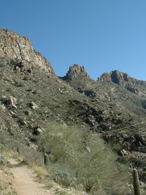
Many plants not only survive the harsh conditions of the Sonoran Desert, but they actually thrive. Many have evolved to have specialized adaptations to the desert climate. The Sonoran Desert includes such plant from the agave family, palm family, cactus family, legume family, and many others.
Colorado Desert
The Colorado Desert is a part of the larger Sonoran Desert in the southeastern part of the U.S. state of California and the northeastern portion of the Mexican state of Baja California. It encompasses approximately 2,500 sq mi (40,000 km²) east of Los Angeles and San Diego, extending from the San Bernardino Mountains east and southeast to the Colorado River, from which it takes its name.
The region is essentially the northwest extension of the Sonoran Desert to the southeast. The region includes the heavily-irrigated Coachella and Imperial valleys on the north and south side of the Salton Sea respectively. It is crossed by several mountain ranges, including the San Jacinto, Santa Rosa, Little San Bernardino, and Chocolate mountains.
It is also dominated by the San Andreas Transform Fault System. It is a pull-apart basin, a baby mid-oceanic ridge.
Joshua Tree National Park is located on the northern edge of the region and includes many of the unique species and habitats of the region. Santa Rosa and San Jacinto National Monument, created in 2000, encompasses much of the San Jacinto and Santa Rosa mountains along the western side of the region.
Anza-Borrego Desert State Park, the largest state park in the contiguous United States, covers 600,000 acres (2400 km²) from the edge of the coastal mountains east of San Diego to the Salton Sea and south almost to the US-Mexico border.
Yuma Desert
The Yuma Desert is a lower-elevation section of the Sonoran Desert in the southwestern United States and the northwest of Mexico. It is in the Salton basin. The desert contains areas of sparse vegetation and has notable areas of sand dunes. With an average rainfall less than 8 inches each year, this is among the harshest deserts in North America. Human presence is sparse throughout, the largest town being Yuma, Arizona.
The desert includes the lower-elevation parts of the southwestern corner of Arizona, extending west to the Colorado River. On the other side of the river, in California, is the Low Desert region of the Sonoran Desert, also referred to as the Colorado Desert. Though the two regions are separated only by the Colorado River, there are numerous species of plant and animals that live only on one side or the other, such as saguaro cactus, which occurs only east of the river. The Yuma Desert also includes the sandy plains of western Sonora, going all the way to the head of the Gulf of California, then an inland strip reaching into the central Sonoran interior. The most significant river in this desert is the Gila River of Arizona. Organ Pipe Cactus National Monument is located in this desert, as are the Kofa National Wildlife Refuge and Cabeza Prieta National Wildlife Refuge.
Yuman vegetation is dominated by the Creosote bush (Larrea tridentata), which is widespread. The saguaro cactus Carnegiea gigantea and the ocotillo Fouquieria splendens are common on the bajadas, while many of the desert trees found are restricted to dry watercourses; these include palo verdes Parkinsonia, the desert willow Chilopsis linearis, ironwood Olneya tesota, and smoke trees Psorothamnus spinosus.
Sonoran Desert National Monument
Sonoran Desert National Monument is located in the U.S. state of Arizona. Created by Presidential proclamation on January 17, 2001, the 496,337 acre (2,008 km²) monument is managed by the U.S. Bureau of Land Management, an agency within the U.S. Department of the Interior. The U.S. Bureau of Land Management already managed the lands, however under monument status, the level of protection and preservation of resources is enhanced. Sonoran Desert National Monument protects but a small portion of the Sonoran Desert, which is 120,000 square miles (311,000 km²), and extends well into California and the country of Mexico. The North Maricopa Mountains, South Maricopa Mountains and the Table Top Wildernesses protect the richest regions of desert habitat from any future development.
Spanish missions in the Sonoran Desert
The Spanish missions in the Sonoran Desert are a series of religious outposts established by Spanish Catholic Jesuits and other orders to spread the Christian doctrine among the local Native Americans, but with the added benefit of giving Spain a toehold in the frontier lands of its colony of New Spain. The missions are in an area of the Sonoran Desert called "Pimería Alta," or "Upper Pima Country." It is now divided between the Mexican state of Sonora and the U.S. state of Arizona.
Father Kino
From 1493, the Kingdom of Spain had maintained a number of missions throughout Nueva España (New Spain, consisting of Mexico and portions of what today are the Southwestern United States) in order to facilitate colonization of these lands.
In the Spring of 1687, a Jesuit missionary named Father Eusebio Francisco Kino lived and worked with the Native Americans in the area called the "Pimería Alta," or "Upper Pima Country," which presently is located in northern Sonora and southern Arizona. During Father Eusebio Kino's stay in the Pimería Alta, he founded over twenty missions in eight mission districts.
It was rumored that the Jesuit priests had amassed fortunes and were becoming very powerful. On February 3, 1768, King Carlos III ordered the Jesuits forcibly expelled from New Spain and returned to the home country.
The missions
- Mission Nuestra Señora de los Dolores: founded on March 13, 1687. This was the first mission founded by Father Kino. By 1744, the mission was abandoned. The cemetery remains on the site of the Tumacácori National Historical Park in Southern Arizona.
- Nuestra Señora de los Remedios was founded in 1687 and was abandoned by 1730. Nothing remains of this mission.
- San Ignacio de Cabórica was founded in 1687 and is located in San Ignacio, Sonora.
- San Pedro y San Pablo del Tubutama was founded in 1687
- Santa Teresa de Atil was founded in 1687
- Santa Maria Magdalena was founded in 1687, located in Sonora.
- San José de Imuris was founded in 1687.
- Nuestra Señora del Pilar y Santiago de Cocóspera was founded in 1689. It is located in Cocóspera, Sonora.
- San Antonio Paduano del Oquitoa was founded in 1689. It is located in Oquitoa, Sonora.
- San Diego del Pitiquito was founded in 1689. It is located in Pitiquito, Sonora.
- San Luis Bacoancos was founded in 1691
- San Cayetano de Tumacácori Mission was built in 1732, but construction stopped in 1822 due to lack of funds. The farming land around the mission was sold at auction in 1834 and the mission was abandoned by 1840. It is now a National Monument in Tumacácori National Historical Park in Southern Arizona.
- Los Santos Ángeles de Guevavi was founded in 1691
- San Lázaro was founded in 1691
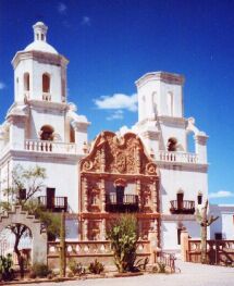
- San Xavier del Bac (O'odham [Papago]: Va:k), now in Tucson, Arizona, founded in 1692, the present building dates from 1785. The interior is richly decorated with ornaments showing a mixture of New Spain and Native American artistic motifs. It is still used by Tohono O'odham and Yaqui tribal members.
- San Cosme y Damián de Tucson: 1692
- Santa María Suamca: 1693
- Nuestra Señora de Loreto y San Marcelo de Sonoyta: 1693
- Nuestra Señora de la Ascención de Opodepe: 1704
- Los Santos Reyes de Sonoita/San Ignacio de Sonoitac: a rancheria near Tumacacori, 1692
Notes
Sources and Further Reading
- Abbey, Edward. 1973. Cactus country. New York: Time-Life Books.
- Alcock, John. 1990. Sonoran Desert summer. Tucson: University of Arizona Press. ISBN 0816511500 and ISBN 9780816511501
- Phillips, Steven, and Patricia Wentworth Comus. 2000. A natural history of the Sonoran Desert. Tucson: Arizona-Sonora Desert Museum. ISBN 0520220293 and ISBN 9780520220294
- Alcock, John. 1985. Sonoran Desert spring. Chicago: University of Chicago Press. ISBN 0226012581 and ISBN 9780226012582
- Dykinga, Jack W., and Charles Bowden. 1992. The Sonoran Desert. New York: H.N. Abrams. ISBN 0810938243 and ISBN 9780810938243
- Edmund C. Jaeger, The North American Deserts (Stanford University Press, 1957), pp. 73-83
- The Pimeria Alta : missions & more, Tucson, Ariz. : Southwestern Mission Research Center, 1996.
- Buford L. Pickens, The Missions of Northern Sonora, A 1935 Field Documentation, Tucson, University of Arizona Press, 1993 reprint. Retrieved May 19, 2007.
External links
- McGinnies, William G. An Overview of the Sonoran Desert. Sonoran Desert. Retrieved April 28, 2007.
- Plagens, Michael J. March 13, 2007. Sonoran Desert Naturalist. Arizonensis. Retrieved April 28, 2007.
- Sonoran Desert Geology. Arizona Roadside Environments. Retrieved April 28, 2007.
- October 18, 2002. Map of the Sonoran Desert. Sonoran Desert. Retrieved April 28, 2007.
- Sonoran Desert. Bio Images. Retrieved April 28, 2007.
- Britannica.com Yuma Desert. Encyclopedia Britannica. Retrieved May 19, 2007.
- Kino Missions. National Park Service. Retrieved May 19, 2007.
- Kino Missions. Mission Churches of the Sonoran Desert. Retrieved May 19, 2007.
- Winckler, Suzanne. January 28, 2001. In the Footsteps of a Bold Priest. New York Times. Retrieved May 19, 2007.
- Bibliography, Kino Missions. Mission Churches of the Sonoran Desert. Retrieved May 19, 2007.
Links to Parks and Recreational Areas within the Sonora Desert
- March 14, 2007$. Saguaro National Park. National Park Service. Retrieved April 28, 2007.
- Sonoran desert. World Wildlife. Retrieved April 28, 2007.
- South Mountain Park/Preserve. Phoenix. Retrieved April 28, 2007.
| Deserts |
|---|
| Ad-Dahna | Alvord | Arabian | Aral Karakum | Atacama | Baja California | Barsuki | Betpak-Dala | Chalbi | Chihuahuan | Dasht-e Kavir | Dasht-e Lut | Dasht-e Margoh | Dasht-e Naomid | Gibson | Gobi | Great Basin | Great Sandy Desert | Great Victoria Desert | Kalahari | Karakum | Kyzylkum | Little Sandy Desert | Mojave | Namib | Nefud | Negev | Nubian | Ordos | Owyhee | Qaidam | Registan | Rub' al Khali | Ryn-Peski | Sahara | Saryesik-Atyrau | Sechura | Simpson | Sonoran | Strzelecki | Syrian | Taklamakan | Tanami | Thar | Tihamah | Ustyurt |
| Colorado River system |
|---|
| Dams and aqueducts (see US Bureau of Reclamation) |
| Shadow Mountain Dam | Granby Dam | Glen Canyon Dam | Hoover Dam | Davis Dam | Parker Dam | Palo Verde Diversion Dam | Imperial Dam | Laguna Dam | Morelos Dam | Colorado River Aqueduct | San Diego Aqueduct | Central Arizona Project Aqueduct | All-American Canal | Coachella Canal | Redwall Dam |
| Natural features |
| Colorado River | Rocky Mountains | Colorado River Basin | Grand Lake | Sonoran desert | Mojave desert | Imperial Valley | Colorado Plateau | Grand Canyon | Glen Canyon | Marble Canyon | Paria Canyon | Gulf of California/Sea of Cortez | Salton Sea |
| Tributaries |
| Dirty Devil River | Dolores River | Escalante River | Gila River | Green River | Gunnison River | Kanab River | Little Colorado River | Paria River | San Juan River | Virgin River |
| Major reservoirs |
| Fontenelle Reservoir | Flaming Gorge Reservoir | Taylor Park Reservoir | Navajo Reservoir | Lake Powell | Lake Mead | Lake Havasu |
| Dependent states |
| Arizona | California | Colorado | Nevada | New Mexico | Utah (See: Colorado River Compact) |
| Designated areas |
| Glen Canyon National Recreation Area | Lake Mead National Recreation Area |
Credits
New World Encyclopedia writers and editors rewrote and completed the Wikipedia article in accordance with New World Encyclopedia standards. This article abides by terms of the Creative Commons CC-by-sa 3.0 License (CC-by-sa), which may be used and disseminated with proper attribution. Credit is due under the terms of this license that can reference both the New World Encyclopedia contributors and the selfless volunteer contributors of the Wikimedia Foundation. To cite this article click here for a list of acceptable citing formats.The history of earlier contributions by wikipedians is accessible to researchers here:
- Sonoran_Desert history
- Sonoran_Desert_National_Monument history
- Yuma_Desert history
- Colorado_Desert history
- Spanish_missions_in_the_Sonoran_Desert history
The history of this article since it was imported to New World Encyclopedia:
Note: Some restrictions may apply to use of individual images which are separately licensed.


