Difference between revisions of "Montevideo" - New World Encyclopedia
m (→Population) |
|||
| Line 1: | Line 1: | ||
{{Started}}{{Contracted}} | {{Started}}{{Contracted}} | ||
| − | + | [[Image:salvo palacio.jpg|thumb|right|200px|The ''Plaza Independencia'', Independence Square.]] | |
| − | + | '''Montevideo''' ({{IPA2|monteβi'deo}}) is the largest city, capital, and chief port of [[Uruguay]]. Montevideo is the only city in the country with a population over 1 million. It has a privileged harbor, one of the most important in the [[Americas]], and beautiful beaches. It quality of life is considered the highest in Latin America. (followed by [[Buenos Aires]] and [[Santiago de Chile]])<ref>[http://www.answers.com/topic/ranking-of-latin-american-cities Ranking of Latin American cities, Quality of life section]. </ref> and is among the 30 safest cities in the world. <ref>[http://www.propertyinuruguay.com/open-realty236%5B1%5D/index.php Property in Uruguay]</ref> | |
| − | |||
| − | |||
| − | |||
| − | | | ||
| − | |||
| − | |||
| − | |||
| − | |||
| − | |||
| − | |||
| − | |||
| − | |||
| − | |||
| − | |||
| − | |||
| − | |||
| − | |||
| − | |||
| − | |||
| − | |||
| − | |||
| − | |||
| − | '''Montevideo''' ({{IPA2|monteβi'deo}}) is the largest city, capital and chief port of [[Uruguay]]. Montevideo is the only city in the country with a population over 1 million. | ||
==Population== | ==Population== | ||
| − | As of 2004, the | + | [[Image:Montevideouruguaynasa.jpg|thumb|200px|left|Montevideo from space]] |
| + | As of 2004, the Montevideo had a population of 1.35 million out of a total of 3.43 million in the country as a whole. The greater [[metropolitan area]] has 1.8 million people | ||
| − | Montivideans have very strong European origins, with Italian and Spanish descent being the most common. There are also important African descent and Jewish communities. | + | Montivideans have very strong European origins, with Italian and Spanish descent being the most common. There are also important African-descent and Jewish communities. |
| − | Montevideo's population makes up roughly 44 percent of the entire country of Uruguay. | + | Montevideo's population makes up roughly 44 percent of the entire country of Uruguay. The surrounding province of [[Canelones]], essentially Montevideo's suburbs and direct rural area, makes up another 12 percent. |
==Geography== | ==Geography== | ||
| − | + | [[Image:Uruguay mapa.png|thumb|200px|]] | |
Montevideo lies at the midpoint of Uruguay's coast, where an estuary called the [[Rio de la Plata]] meets the Atlantic Ocean. The geographic coordinates are 34.5° S, 56°W. | Montevideo lies at the midpoint of Uruguay's coast, where an estuary called the [[Rio de la Plata]] meets the Atlantic Ocean. The geographic coordinates are 34.5° S, 56°W. | ||
| − | The Avenida 18 de Julio is the city's main artery and extends from the [[Plaza Independencia]], through the main business district. The park is surrounded by historic buildings that include the Government House, the Museum of Natural History, the Salvo Palace, the Solis Theater, and the Victoria Plaza Hotel. On the plaza is the black-marbled mausoleum of Independence leader [[Jose Gervasio Artigas]], topped by an enormous statue of the national hero. The avenue gets its name from July 18, 1830, the date Uruguay adopted its first constitution. West of the plaza, an arch leads to a historic district called ''[[Ciudad Vieja, Montevideo|Ciudad Vieja]]'' or Old Town. This district has many buildings that date from the 1700s or 1800s. | + | The Avenida 18 de Julio is the city's main artery and extends from the [[Plaza Independencia]], through the main business district. The park is surrounded by historic buildings that include the Government House, the Museum of Natural History, the [[Salvo Palace]], the [[Solis Theater]], and the [[Victoria Plaza Hotel]]. On the plaza is the black-marbled mausoleum of Independence leader [[Jose Gervasio Artigas]], topped by an enormous statue of the national hero. The avenue gets its name from July 18, 1830, the date Uruguay adopted its first constitution. West of the plaza, an arch leads to a historic district called ''[[Ciudad Vieja, Montevideo|Ciudad Vieja]]'' or Old Town. This district has many buildings that date from the 1700s or 1800s. |
| − | |||
| − | |||
| − | |||
| − | |||
| − | |||
| − | |||
| − | |||
| − | |||
| − | |||
==History== | ==History== | ||
| − | === | + | ===Name=== |
| − | + | There are at least two explanations for the name ''Montevideo''. The first states that it comes from the [[Portuguese language|Portuguese]] ''Monte vide eu'', which means "I see a mountain." The second is that the Spaniards recorded the location of a mountain in a map as "Monte VI De Este a Oeste" meaning "The sixth mountain from east to west." The city's full original name is '''San Felipe y Santiago de Montevideo'''. | |
| − | There are at least two explanations for the name ''Montevideo'' | ||
===Early History=== | ===Early History=== | ||
| Line 59: | Line 27: | ||
This changed however, when in 1680 the [[Portugal|Portuguese]] founded [[Colonia del Sacramento]], across the Rio de la Plata from [[Buenos Aires]], despite Spanish claims to the area based on the [[Treaty of Tordesillas]]. | This changed however, when in 1680 the [[Portugal|Portuguese]] founded [[Colonia del Sacramento]], across the Rio de la Plata from [[Buenos Aires]], despite Spanish claims to the area based on the [[Treaty of Tordesillas]]. | ||
| − | The [[Spain|Spanish]] | + | The [[Spain|Spanish]] force the Portuguese out of a fort in the area in 1724. Then, [[Bruno Mauricio de Zabala]] – [[governor]] of Buenos Aires – founded the city of Montevideo on December 24, 1726 to prevent further incursions. |
| + | [[Image:Karte Montevideo MKL1888 kl.png|thumb|200px|1888 German map of Montevideo]] | ||
| − | From 1807 to 1830 Montevideo was alternately occupied by British, Spanish, Argentine, Portuguese, and Brazilian forces, and its trade and population declined. In 1828, the town became the capital of Uruguay. However independence, which came in 1830, did not bring stability. Rivalries between local inhabitants, Argentines, and Brazilians led to a nine-year siege of Montevideo by a combined Argentine-Uruguayan army from 1843 to 1851. French and English forces assisted Montevideo's defenders by blockading Buenos Aires. The unexpected result was that Montevideo flourished during the siege and became the major port of the Río de la Plata. | + | From 1807 to 1830 Montevideo was alternately occupied by British, Spanish, Argentine, Portuguese, and Brazilian forces, and its trade and population declined. In 1828, the town became the capital of Uruguay. However, independence, which came in 1830, did not bring stability. Rivalries between local inhabitants, Argentines, and Brazilians led to a nine-year siege of Montevideo by a combined Argentine-Uruguayan army from 1843 to 1851. French and English forces assisted Montevideo's defenders by blockading Buenos Aires. The unexpected result was that Montevideo flourished during the siege and became the major port of the Río de la Plata. |
| − | The city fell under | + | The city fell under [[United Kingdom|British]] influence from the early [[nineteenth century]] until the early [[twentieth century]] as a way to circumvent [[Argentine]] and [[Brazilian]] commercial control. It was repeatedly besieged by Argentine dictator [[Juan Manuel de Rosas]] between 1838 and 1851. Between 1860 and 1911, British-owned railway companies built an extensive [[railroad]] network linking the city to the surrounding countryside. |
===Twentieth Century=== | ===Twentieth Century=== | ||
| − | |||
[[Image:MontevideoIndependencePlaza1900.jpg|thumb|left|200px|Independence Plaza, c. 1900]] | [[Image:MontevideoIndependencePlaza1900.jpg|thumb|left|200px|Independence Plaza, c. 1900]] | ||
| − | |||
During the early 1900s Uruguay became one of the most prosperous and democratic nations in South America. | During the early 1900s Uruguay became one of the most prosperous and democratic nations in South America. | ||
| − | Jose Batlle y Ordoñez, president from 1903 to 1907 and again from 1911 to 1915, initiated widespread political, social, and economic reforms that established a statist tradition. | + | Jose Batlle y Ordoñez, president from 1903 to 1907 and again from 1911 to 1915, initiated widespread political, social, and economic reforms that established a statist tradition. Some of these reforms were continued by his successors. |
| − | + | However, an economic decline during the 1950s and 1960s brought about a period of widespread unrest. In the late 1960s a violent Marxist urban guerrilla movement called the [[Tupamaros]] carried out kidnappings and murders of Uruguayan and foreign officials. This led Uruguay's president to cede control of the government to the military in 1973. By year's end, the rebels had been crushed, but the military continued to expand its hold over the government. Civilian rule was not restored until 1985. | |
| − | In 2004, the left-of-center [[Frente Amplio]] (Broad Front Coalition) won national elections that effectively ended 170 years of political control previously held by the [[Partido Colorado]] and [Partido Blanco]] parties | + | In 2004, the left-of-center [[Frente Amplio]] (Broad Front Coalition) won national elections that effectively ended 170 years of political control previously held by the [[Partido Colorado]] and [Partido Blanco]] parties. |
Since 2005 the [[Mayor]] of Montevideo (''Intendente Municipal'' in Spanish) has been [[Ricardo Ehrlich]], of the [[Frente Amplio]], gaining 61 percent of the vote and beating [[Pedro Bordaberry]] of the center-right [[Partido Colorado]], who scored 27 percent. | Since 2005 the [[Mayor]] of Montevideo (''Intendente Municipal'' in Spanish) has been [[Ricardo Ehrlich]], of the [[Frente Amplio]], gaining 61 percent of the vote and beating [[Pedro Bordaberry]] of the center-right [[Partido Colorado]], who scored 27 percent. | ||
==Growth/economy== | ==Growth/economy== | ||
| − | + | [[Image:Torreantel.JPG|thumb|right|170px|Torre de las Telecomunicaciones ([[Torre Antel|Antel Tower]]) in Montevideo.]] | |
The [[military dictatorship]] of the 1970s and [[economic stagnation]] caused a decline whose residual effects are still seen today. Many rural poor flooded the city, with a large concentration in Ciudad Vieja. | The [[military dictatorship]] of the 1970s and [[economic stagnation]] caused a decline whose residual effects are still seen today. Many rural poor flooded the city, with a large concentration in Ciudad Vieja. | ||
| Line 90: | Line 57: | ||
The port is also served by the [[Carrasco International Airport]]. Four railroads converge on the city, and roads lead to other principal cities. | The port is also served by the [[Carrasco International Airport]]. Four railroads converge on the city, and roads lead to other principal cities. | ||
| − | |||
| − | |||
==Education== | ==Education== | ||
| − | The city has an excellent system of public education and is the home of the University of the Republic and the Technical University of Uruguay. Higher education in Uruguay is available only in the capital. | + | The city has an excellent system of public education and is the home of the [[University of the Republic]] and the Technical University of Uruguay. Higher education in Uruguay is available only in the capital. |
==Culture== | ==Culture== | ||
| Line 109: | Line 74: | ||
[[Image:Montevideo Pocitos.JPG|800px|Montevideo,Pocitos Neighborhood]] | [[Image:Montevideo Pocitos.JPG|800px|Montevideo,Pocitos Neighborhood]] | ||
| − | |||
| − | |||
== References == | == References == | ||
| Line 125: | Line 88: | ||
Country Profile: Uruguay. BBC News. July 13, 2007 | Country Profile: Uruguay. BBC News. July 13, 2007 | ||
http://news.bbc.co.uk/2/hi/americas/country_profiles/1229360.stm | http://news.bbc.co.uk/2/hi/americas/country_profiles/1229360.stm | ||
| − | |||
<references /> | <references /> | ||
| Line 140: | Line 102: | ||
{{Geolinks-cityscale|-34.8937|-56.1573}} | {{Geolinks-cityscale|-34.8937|-56.1573}} | ||
*[http://www.myspace.com/montevideopop Montevideo Pop Music: Site of the band with the name of the city] | *[http://www.myspace.com/montevideopop Montevideo Pop Music: Site of the band with the name of the city] | ||
| − | |||
| − | |||
| − | |||
{{South American capitals}} | {{South American capitals}} | ||
Revision as of 01:58, 22 September 2007
Montevideo (IPA: [monteβi'deo]) is the largest city, capital, and chief port of Uruguay. Montevideo is the only city in the country with a population over 1 million. It has a privileged harbor, one of the most important in the Americas, and beautiful beaches. It quality of life is considered the highest in Latin America. (followed by Buenos Aires and Santiago de Chile)[1] and is among the 30 safest cities in the world. [2]
Population
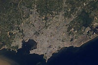
As of 2004, the Montevideo had a population of 1.35 million out of a total of 3.43 million in the country as a whole. The greater metropolitan area has 1.8 million people
Montivideans have very strong European origins, with Italian and Spanish descent being the most common. There are also important African-descent and Jewish communities.
Montevideo's population makes up roughly 44 percent of the entire country of Uruguay. The surrounding province of Canelones, essentially Montevideo's suburbs and direct rural area, makes up another 12 percent.
Geography
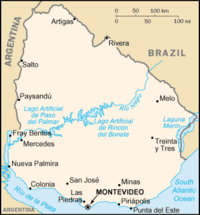
Montevideo lies at the midpoint of Uruguay's coast, where an estuary called the Rio de la Plata meets the Atlantic Ocean. The geographic coordinates are 34.5° S, 56°W.
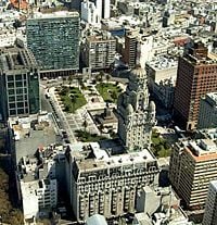
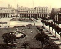
The Avenida 18 de Julio is the city's main artery and extends from the Plaza Independencia, through the main business district. The park is surrounded by historic buildings that include the Government House, the Museum of Natural History, the Salvo Palace, the Solis Theater, and the Victoria Plaza Hotel. On the plaza is the black-marbled mausoleum of Independence leader Jose Gervasio Artigas, topped by an enormous statue of the national hero. The avenue gets its name from July 18, 1830, the date Uruguay adopted its first constitution. West of the plaza, an arch leads to a historic district called Ciudad Vieja or Old Town. This district has many buildings that date from the 1700s or 1800s.
History
Name
There are at least two explanations for the name Montevideo. The first states that it comes from the Portuguese Monte vide eu, which means "I see a mountain." The second is that the Spaniards recorded the location of a mountain in a map as "Monte VI De Este a Oeste" meaning "The sixth mountain from east to west." The city's full original name is San Felipe y Santiago de Montevideo.
Early History
The first European to explore Uruguay was the Spanish navigator Juan Díaz de Solís in 1516. He and his group were killed by Charrúa or Guaraní Indians.
The Portuguese explorer Ferdinand Magellan anchored at the future site of Montevideo in 1520, and the British navigator Sebastian Cabot led a Spanish expedition up the Río de la Plata in 1526. The area attracted little interest for settlement owing to a lack of mineral wealth and the hostility of the Indians.
This changed however, when in 1680 the Portuguese founded Colonia del Sacramento, across the Rio de la Plata from Buenos Aires, despite Spanish claims to the area based on the Treaty of Tordesillas.
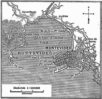
The Spanish force the Portuguese out of a fort in the area in 1724. Then, Bruno Mauricio de Zabala – governor of Buenos Aires – founded the city of Montevideo on December 24, 1726 to prevent further incursions.
From 1807 to 1830 Montevideo was alternately occupied by British, Spanish, Argentine, Portuguese, and Brazilian forces, and its trade and population declined. In 1828, the town became the capital of Uruguay. However, independence, which came in 1830, did not bring stability. Rivalries between local inhabitants, Argentines, and Brazilians led to a nine-year siege of Montevideo by a combined Argentine-Uruguayan army from 1843 to 1851. French and English forces assisted Montevideo's defenders by blockading Buenos Aires. The unexpected result was that Montevideo flourished during the siege and became the major port of the Río de la Plata.
The city fell under British influence from the early nineteenth century until the early twentieth century as a way to circumvent Argentine and Brazilian commercial control. It was repeatedly besieged by Argentine dictator Juan Manuel de Rosas between 1838 and 1851. Between 1860 and 1911, British-owned railway companies built an extensive railroad network linking the city to the surrounding countryside.
Twentieth Century
During the early 1900s Uruguay became one of the most prosperous and democratic nations in South America.
Jose Batlle y Ordoñez, president from 1903 to 1907 and again from 1911 to 1915, initiated widespread political, social, and economic reforms that established a statist tradition. Some of these reforms were continued by his successors.
However, an economic decline during the 1950s and 1960s brought about a period of widespread unrest. In the late 1960s a violent Marxist urban guerrilla movement called the Tupamaros carried out kidnappings and murders of Uruguayan and foreign officials. This led Uruguay's president to cede control of the government to the military in 1973. By year's end, the rebels had been crushed, but the military continued to expand its hold over the government. Civilian rule was not restored until 1985.
In 2004, the left-of-center Frente Amplio (Broad Front Coalition) won national elections that effectively ended 170 years of political control previously held by the Partido Colorado and [Partido Blanco]] parties.
Since 2005 the Mayor of Montevideo (Intendente Municipal in Spanish) has been Ricardo Ehrlich, of the Frente Amplio, gaining 61 percent of the vote and beating Pedro Bordaberry of the center-right Partido Colorado, who scored 27 percent.
Growth/economy
The military dictatorship of the 1970s and economic stagnation caused a decline whose residual effects are still seen today. Many rural poor flooded the city, with a large concentration in Ciudad Vieja.
In 2002, Uruguay went through the steepest economic and financial crisis in recent history, which developed mostly from external factors. Uruguay’s economy rebounded in 2003—with a 2.5 percent rise in GDP—and surged in 2004 and 2005 with growth rates of 12.3 percent and 6.6 percent, respectively. Growth equaled 7.0 percent in 2006 and is expected to reach 4.5 percent in 2007.
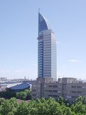
The Uruguayan government employs more than one-third of the workers of Montevideo. The city's important industries include textile manufacturing, banking, and tourism. Wines and dairy products also are produced.
Most of Uruguay's exports and imports pass through Montevideo's port. Among the main exports are wool, meat, and hides.
The port is also served by the Carrasco International Airport. Four railroads converge on the city, and roads lead to other principal cities.
Education
The city has an excellent system of public education and is the home of the University of the Republic and the Technical University of Uruguay. Higher education in Uruguay is available only in the capital.
Culture
Montevideo's first theater was the Casa de Comedias, which opened in 1795. This was followed by the Teatro San Felipe. The Teatro Solís, still in existence, was opened in 1856. The city also houses the Museo Histórico Nacional (National History Museum, 1900), the Museo Nacional de Historia Natural (Museum of Natural History, 1837), the Museo Nacional de Bellas Artes (Museum of Fine Arts, 1911), and the Biblioteca Nacional del Uruguay (National Library, 1816).
Media
Montevideo is the center of Uruguay's publishing industry. Most of the country's daily newspapers are published here, with several having national circulations. Many of the major dailies are owned by or affiliated with the major political parties.
The leading government and private radio and television stations also broadcast from Montevideo. Use of the Internet has grown rapidly since the mid-1990s.
Sports and Recreation
Soccer is the most popular sport in Montevideo and Uruguay. The city's Estadio Centenario (Centennial Stadium), is world famous, and hosted the 1930 1st FIFA World Cup. Other popular sports include basketball and rugby. Gaucho rodeos, called domos, attract many spectators. The city's fine beaches draw large crowds in the summer.
ReferencesISBN links support NWE through referral fees
Montevideo. (2007). Encyclopedia Britannica. Encyclopedia Britannica 2007 Deluxe Edition. Chicago: Encyclopedia Britannica. ASIN B000GCBOJ8
Hudson, Rex A., Meditz, Sandra W., eds. Uruguay: A country study. 1990, second edition. Washington: Federal Research Division, Library of Congress. ISBN 0844407372
Uruguay. (2007) The CIA World Factbook https://www.cia.gov/library/publications/the-world-factbook/print/uy.html
Background Note: Uruguay. U.S. State Department Bureau of Western Hemisphere Affairs. June 2007 http://www.state.gov/r/pa/ei/bgn/2091.htm
Country Profile: Uruguay. BBC News. July 13, 2007 http://news.bbc.co.uk/2/hi/americas/country_profiles/1229360.stm
External links
- Montevideo official website
- (Spanish) PRESS The First Uruguayan Neighborhood and Documentatio Agency
- (Spanish)/(English) A City Built by Us All
- Many nice pictures of Montevideo
- Panoramic pictures of Montevideo
- Montevideo Hotels
- A Maverick's Odyssey - Photo blog of life in Montevideo, Uruguay.
- Uruguay Dreaming - Blog about life and customs in Montevideo and Uruguay.
-
- Mapping from Multimap or GlobalGuide or Google Maps
- Satellite image from WikiMapia
- Mapping from OpenStreetMap
- Montevideo Pop Music: Site of the band with the name of the city
Asunción, Paraguay · Bogotá, Colombia · Brasília, Brasil · Buenos Aires, Argentina · Caracas, Venezuela · Cayenne, French Guiana · Georgetown, Guyana · Grytviken, South Georgia and the South Sandwich Islands · La Paz, Bolivia · Lima, Peru · Montevideo, Uruguay · Paramaribo, Suriname · Quito, Ecuador · Santiago, Chile · Sucre, Bolivia · Stanley, Falkland Islands
Credits
New World Encyclopedia writers and editors rewrote and completed the Wikipedia article in accordance with New World Encyclopedia standards. This article abides by terms of the Creative Commons CC-by-sa 3.0 License (CC-by-sa), which may be used and disseminated with proper attribution. Credit is due under the terms of this license that can reference both the New World Encyclopedia contributors and the selfless volunteer contributors of the Wikimedia Foundation. To cite this article click here for a list of acceptable citing formats.The history of earlier contributions by wikipedians is accessible to researchers here:
The history of this article since it was imported to New World Encyclopedia:
Note: Some restrictions may apply to use of individual images which are separately licensed.
