Difference between revisions of "Darfur" - New World Encyclopedia
(added Darfur link) |
Mary Anglin (talk | contribs) (claimed for brooke winger) |
||
| Line 1: | Line 1: | ||
| − | + | {{Claimed}} | |
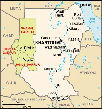
'''Darfur''' ([[Arabic language|Arabic]] دار فور, meaning "home of the [[Fur people|Fur]]") is a region of far western [[Sudan]], bordering the [[Central African Republic]], [[Libya]], and [[Chad]]. It is divided into three federal states within [[Sudan]]: Gharb Darfur ([[West Darfur]]), Janub Darfur ([[South Darfur]]), and Shamal Darfur ([[North Darfur]]). | '''Darfur''' ([[Arabic language|Arabic]] دار فور, meaning "home of the [[Fur people|Fur]]") is a region of far western [[Sudan]], bordering the [[Central African Republic]], [[Libya]], and [[Chad]]. It is divided into three federal states within [[Sudan]]: Gharb Darfur ([[West Darfur]]), Janub Darfur ([[South Darfur]]), and Shamal Darfur ([[North Darfur]]). | ||
Revision as of 06:47, 11 July 2007
Darfur (Arabic دار فور, meaning "home of the Fur") is a region of far western Sudan, bordering the Central African Republic, Libya, and Chad. It is divided into three federal states within Sudan: Gharb Darfur (West Darfur), Janub Darfur (South Darfur), and Shamal Darfur (North Darfur).
Geography and climate
Darfur covers an area of some 493 180 km² (196,555 miles²)—about three-quarters the size of Texas, more than half the size of Kenya or slightly smaller than France. It is largely an arid plateau with the Marrah Mountains (Jebel Marra), a range of volcanic peaks rising up to 3000 m (10,100 ft), in the center of the region. The region's main towns are Al Fashir, Nyala, and Geneina.
There are four main features of the physical geography. The whole eastern half of Darfur is covered with plains and low hills of sandy soils, known as goz, and sandstone hills. In many places the goz is waterless and can only be inhabited where there are water reservoirs or deep boreholes. While dry, goz may also support rich pasture and arable land. To the north the goz is overtaken by the desert sands of the Sahara. A second feature are the wadis, seasonal watercourses ranging from small rivulets that flood only occasionally during the wet season to large wadis that flood for most of the rains and flow from western Darfur hundreds of miles west to Lake Chad. Many wadis have pans of alluvial deposit with rich soil that are also difficult to cultivate. The west of Darfur is dominated by the third feature, basement rock, sometimes covered with a thin layer of sandy soil. Basement rock is too infertile to be farmed, but provides sporadic forest cover that can be grazed by animals. The fourth and final feature are the Marrah Mountains, volcanic plugs created by a massif, that rise up to a peak at Deriba crater where there is a small area of temperate climate, high rainfall and permanent springs of water.
The rainy season is from June to September, transforming much of the region from dusty brown to verdant green. As much of the population of Darfur is agricultural, the rains are vital. In normal years, millet, a mainstay crop is ready to be harvested by November. Once harvested, the dry stalks may be fed to domestic livestock. In the far northern desert, years may pass between rainfall. In the far south, annual average rainfall is 700 mm and many trees remain green year-round.[1]
Economy and demography
Darfur has an estimated population of 7.4 million people. Darfur's economy is primarily based on subsistence agriculture, producing cereals, fruit and tobacco as well as livestock in the drier north.
During the Sultanate of the Keira Dynasty, the region had developed the demographic structure that would endure for the twentieth century. The agricultural Fur were located in the remnants of the sultanate in the center. Just north of them were the Tunjur, who had ruled before the sultanate. From the northwest came Nilo-Saharan cultivators who also practiced varying degrees of animal husbandry, such as the Berti and Zaghawa. The Nubian-speaking Birged and Meidob peoples, also farmers, came from the northeast. To the west lay Dar Masalit; the Masalit had successfully maintained their independence from Dar Fur. Bedouin Arabs came from the far northwest, including the Ta’isha, Rizeigat, Habbaniya, and Beni Halba. While Arabs in the north continued to herd camels, those who ventured south, where there was comparatively abundant rainfall mixed with a later migration of Fula speakers, began to herd cattle, forming the Baggara (literally, "those of the cow"),[2] who settled in the southeast. The agriculturalists settled around predictable water sources, primarily wadis that flooded during the rainy season from June to September, while the Baggara, Zaghawa and other pastoralists are semi-nomadic or transhumant, taking their herds north during the rainy season as the arid landscape turns green and then retreating south as the vegetation withers. Most of the Baggara split their families, one part staying south to cultivate crops and the other taking the herds along regular routes, though occasionally the herders would seek water or grazing rights from a farming community along the route, periodically leading to disputes requiring the mediation of local leaders.[3] Externally, the inhabitants of the Nile riverine states referred to themselves as the awlad al-beled ("children of the country") in pride over their primary role and referred to the Westerners as awlad al-gharb ("children of the west"), an implicit slur. Meanwhile, "Africans" were pejoratively known as zurga ("Blacks").[4]
Some of these groups, such as the Misseiria, speak languages other than Arabic natively. Many of these ethnic groups also have significant populations in neighboring Chad, particularly the Zaghawa and Baggara.
Languages
The languages of Darfur include:
- Arabic, particularly south of Nyala and in the east, but also touching the Chad border in a narrow strip north of Jebel Si, between Fur and Zaghawa;
- Beigo, or Baygo, in a small area south of Nyala (this language, closely related to Daju, is now extinct).
- Daju, in a small pocket near Nyala (of the Western branch of the Eastern Sudanic group of Nilo-Saharan);
- Erenga, north of Geneina and across the border in Chad (considered a dialect of Tama);
- Fongoro, south of Sinyar (a o-Bagirmi language of the Central Sudanic group of Nilo-Saharan; this language is nearly extinct; its speakers have shifted to Fur);
- Fulbe, or Fulfulde, in a small area south of Nyala;
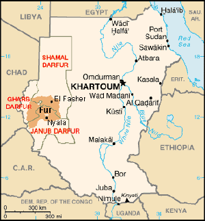
- Fur, in the center, from Wadi Azum in the west to Al Fashir in the east (belonging to the Fur language group of Nilo-Saharan);
- Kujarge, south of Sinyar (unclassified);
- Masalit, west of Wadi Azum and around Geneina; also spoken across the border, and in a small isolated area south of Nyala (belonging to the Maban language group of Nilo-Saharan);
- Sinyar, along the border south of Masalit (also a o-Bagirmi language, see Fongoro above);
- Tama, in a small pocket between Jebel Si and Jebel Marra (also of the Western branch of the Eastern Sudanic group of Nilo-Saharan, see Daju above);
- Zaghawa, in the north (an Eastern Saharan language);
History
The early history of Darfur is dominated by the influence of the Marrah Mountains. Most of the region is semi-arid plain and cannot support a large and complex civilization, while the Marrah Mountains offer plentiful water. The Daju people created the first known Darfuri civilization based in the mountains, though they left no records besides a list of kings. The Tunjur displaced the Daju in the fourteenth century and introduced Islam. The Tunjur sultans intermarried with the Fur and sultan Soleiman (reigned c.1596 to c.1637) is considered the founder of the Keira dynasty. Darfur became a great power of the Sahel under the Keira dynasty, expanding its borders as far east as the Atbarah River and attracting immigrants from Bornu and Bagirmi. During the mid-18th century the country was wracked by conflict between rival factions, and external war with Sennar and Wadai. In 1875, the weakened kingdom was destroyed by the Egyptian government (itself under British colonization) set up in Khartoum, largely through the machinations of al-Zubayr Rahma, a businessman who was competing with the dar over access to slaves and ivory in Bahr el Ghazal to the south of Darfur.
The Darfuris were restive under Egyptian rule, but were no more predisposed to accept the rule of the self proclaimed Mahdi, Muhammad Ahmad, when his forces defeated the British in Darfur in 1883. When Ahmad's successor, Abdallahi ibn Muhammad, himself a Darfuri, demanded that the pastoralist tribes provide soldiers, several tribes rose up in revolt. Following the overthrow of Abdallahi at Omdurman in 1898 by a British force, the new Anglo-Egyptian condominium government recognized Ali Dinar as the sultan of Darfur and largely left the dar to its own affairs except for a nominal annual tribute. During the First World War, the British became concerned that the sultanate might fall under the influence of Turkey, invaded and incorporated Darfur into Sudan in 1916. Under colonial rule, financial and administrative resources were directed to the tribes of central Sudan near Khartoum to the detriment of the outlying regions such as Darfur.
This pattern of skewed development continued following national independence in 1956. To this was added an element of political instability caused by the proxy wars between Sudan, Libya and Chad. The influence of an ideology of Arab supremacy propagated by Libyan president Muammar al-Gaddafi that began to be acted upon by Darfuris, including those identified as "Arab" and "African". A famine in the mid-1980s disrupted many societal structures and led to the first significant fighting amongst Darfuris. A low level conflict continued for the next 15 years, with the government coopting and arming "Arab" militias against its enemies. The fighting reached a peak in 2003 with the beginning of the Darfur conflict, in which the resistance coalesced into a roughly cohesive rebel movement. The conflict soon came to be regarded as one of the worst humanitarian disasters in the world.
See also
- Friedhelm Eronat
- Darfur Conflict
Notes and references
- ↑ de Waal, Alex, Famine that Kills: Darfur, Sudan, Oxford University Press (Revised edition), 2005, ISBN 0-19-518163-8, p. 36
- ↑ Prunier, p. 6
- ↑ de Waal, pp. 36 & 50
- ↑ Prunier, p. xiii & xix
ar:دار فور zh-min-nan:Darfur cs:Dárfúr da:Darfur de:Darfur es:Darfur fr:Darfour id:Darfur it:Darfur nl:Darfoer ja:ダルフール no:Darfur pl:Darfur pt:Darfur ru:Дарфур sl:Darfur fi:Darfur sv:Darfur

