Brazzaville
| ||||||||||||||||||||||||||
File:Brazzaville districts.png Brazzaville district | ||||||||||||||||||||||||||
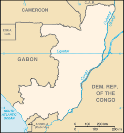
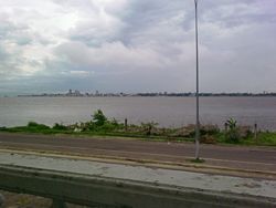
Brazzaville is the capital and largest city of the Republic of the Congo and is located on the Congo River. The populous city of Kinshasa, which is capital of the Democratic Republic of the Congo, lies on the southern bank of the Congo River just across from Brazzaville. This is the only place in the world where two national capital cities are situated on opposite banks of a river, within sight of each other.
Brazzaville was founded in 1880 on the site of a village named Nkuna by an Italian born French explorer, Pierre Savorgnan de Brazza, after whom the city was named.
Geography
Brazzaville is beside the Congo River, 314 miles (506km) inland from the Atlantic Ocean and south of the equator. Surrounded by a vast savanna of high grasslands and dark green thickets of low trees spread over rolling hills, the town is fairly level, with an altitude of 1040 feet (317 meters). The city covers a land area of 38.6 square miles (100 square kilometers).
Located near the Equator, the temperature is quite consistent year-round, with the January temperature being a humid 70°F-88°F (21°C-31°C) and July being 63°F-82°F (17°C-28°C). The average yearly rainfall is around 55 inches (1400mm). The dry season is from June to August while the wet season has two rainfall maxima: one in March–May and another in September–November.
Violent rapids make the Congo River un-navigable from Brazzaville to the Atlantic. To the northeast the river widens into Stanley Pool, which is 15 miles (24km) wide and dotted with small islands during the dry season. From Brazzaville inland, the river becomes navigable for 1000 miles (1600km).
Environmental issues include air pollution from vehicle emissions, and water pollution from the dumping of raw sewage. Tap water is not drinkable.
History
The city was founded on 10 September, 1880 on the site of a village named Nkuna by a Franco-Italian explorer, Pierre Savorgnan de Brazza, after whom the city was named. The local leader, Makoko of the Téké signed a treaty of protection with de Brazza which subjugated his lands to the French Empire. The city was built four years later in order to become a competitor with Léopoldville (now Kinshasa) which was built by the Belgians on the other side of the river. The site was occupied from October 1880 until May 1882 by a small squad of troops led by Senegalese Sergeant Malamine Camara, who prevented the land from falling into Belgian hands.
French control over the area was made official by the Berlin Conference of 1884. The city became the capital first of the French Congo, and then of French Equatorial Africa, a federation of states which encompassed Gabon, the Central African Republic and Chad. In 1924, the Congo-Océan railway was brought into service which linked Brazzaville with the port of Pointe-Noire.
In 1944, Brazzaville hosted a meeting of the Free French forces and representatives of France's African colonies. The resulting Brazzaville Declaration was intended to redefine the relationship between France and its African colonies after World War II.
Until the 1960s, the city was divided into European (the center of the city) and African sections (Poto-Poto, Bacongo, and Makélékélé). In 1980 it became a "commune" separated from the Pool Region and divided into seven "arrondissements": Makélékélé (1), Bacongo (2), Poto-Poto (3), Moungali (4), Ouenzé (5), Talangaï (6) and Mfilou (7).
The city has frequently been a staging ground for regional conflicts, including conflicts between rebel and government forces and between forces of the Republic of Congo, the Democratic Republic of the Congo, and Angola. It was also the scene of bloody civil wars throughout the 1990s which resulted in thousands of civilian deaths and which forced hundreds of thousands of refugees to flee the city.
Government
The Republic of Congo
The chief of state is the president who is elected by popular vote for a seven-year term. The president appoints a Council of Ministers.
The bicameral Parliament consists of the Senate (66 seats; members are elected by indirect vote to serve five-year terms) and the National Assembly (137 seats; members are elected by popular vote to serve five-year terms)
The city is a commune that is separated from the other regions of the republic; it is surrounded by the Pool Region.
In order to distinguish between the two African countries with "Congo" in their names, the Republic of the Congo is sometimes called Congo-Brazzaville, as opposed to Congo-Kinshasa (the Democratic Republic of the Congo, known from 1971 to 1997 as Zaire, the capital of which is Kinshasa).
Economy
Brazzaville is the financial and administrative capital of the republic, and it is home to 40 percent of non-agricultural employment.
Goods arriving at the Atlantic seaport of Pointe-Noire are shipped by rail or truck to Brazzaville, which, due to its position above the rapids, is a transit point for commercial and passenger traffic heading North.
Industries present in Brazzaville include: machine shops, textiles, tanning, and manufacturing. As a key port on the Congo River, the city takes deliveries of raw materials, such as: rubber, wood and agricultural products. From here they are generally sent onward to Pointe-Noire for export.
The city is home to Maya-Maya Airport and a railway station on the Congo-Ocean Railway. It is also an important river port, with ferries sailing to Kinshasa and to Bangui via Impfondo. The port for ferries to Kinshasa is known locally as "The Beach". The Congo River Rapids lie on the outskirts of the city, where the Djoué River meets the Congo, rendering river transport to the coast impossible, qualifying the railway as a portage railway
Demographics
As of the 2001 census, it has a population of 1,018,541 in the city proper, and about 1.5 million in total when including the suburbs located in the Pool Region. The populous city of Kinshasa (more than seven million inhabitants in 2004), capital of the Democratic Republic of the Congo, lies just across the Congo River from Brazzaville. Together with Kinshasa, the combined conurbation of Kinshasa-Brazzaville has thus nearly nine million inhabitants. Over a third of the population of the Republic of Congo lives in the capital.
Estimates for this country's population take into account the effects of excess mortality due to AIDS, which can result in lower life expectancy, higher infant mortality, higher death rates, lower population growth rates, and changes in the distribution of population by age and sex than would otherwise be expected.
Ethnic groups include Kongo 48 percent, Sangha 20 percent, M'Bochi 12 percent, Teke 17 percent, Europeans and other three percent.
Languages used include French, the official language, Lingala and Monokutuba, which are widely used trade languages, as well as many local languages and dialects (of which Kikongo is the most widespread).
Christians make up 50 of the republic's population, animists 48 percent, and Muslims two percent.
Colleges and universities
Of interest
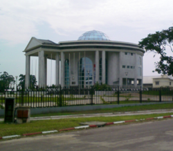
Notable buildings in the city include St Anne's Basilica, built in 1949 by Roger Erell, and known for its green tiled roof; Erell also designed a house in the city for Charles de Gaulle. Other buildings include the Nabemba Tower and the Congressional Palace. Other features include the Marien Ngouabi Mausoleum, Brazzaville Zoo and the Poto-Poto School of Painting.
The World Health Organization Regional Office for Africa is based in Brazzaville on a vast campus at the Cité du Djoué.
ReferencesISBN links support NWE through referral fees
- ↑ (French) Republic of Congo, Centre National de la Statistique et des Etudes Economiques (CNSEE). Répartition de la population par Départements et Communes en 1984 et projetée de 2000 à 2015. Retrieved 2007-06-30.
- ↑ (French) Website of Unité de Pilotage du Processus d'Elaboration et de mise œuvre de la Stratégie pour la Réduction de la Pauvreté (UPPE-SRP). Monographie de la Ville de Kinshasa (SWF). Retrieved 2007-01-19.
- Chavannes, Charles de. (1929) “Le Sergent Sénégalais Malamine.” Annales de l’Académie des Sciences Coloniales, vol. 3:159-187.
- Petringa, Maria. (2006) Brazza, A Life for Africa (2006) ISBN 9781-4259-11980
- Tiepolo, M. (1996) "City Profile: Brazzaville" in Cities v. 13, pp. 117-124
- Brisset-Guibert, Hervé (2007) Brazzavile petit guide historique, in the site www.presidence.cg ("palais presidentiel")
External links
- World Fact Book Republic of Congo Retrieved August 3, 2008.
- Congo-Brazzaville Retrieved August 3, 2008.
Credits
New World Encyclopedia writers and editors rewrote and completed the Wikipedia article in accordance with New World Encyclopedia standards. This article abides by terms of the Creative Commons CC-by-sa 3.0 License (CC-by-sa), which may be used and disseminated with proper attribution. Credit is due under the terms of this license that can reference both the New World Encyclopedia contributors and the selfless volunteer contributors of the Wikimedia Foundation. To cite this article click here for a list of acceptable citing formats.The history of earlier contributions by wikipedians is accessible to researchers here:
The history of this article since it was imported to New World Encyclopedia:
Note: Some restrictions may apply to use of individual images which are separately licensed.


