Difference between revisions of "Solomon Islands" - New World Encyclopedia
Mike Butler (talk | contribs) (Solomon Islands — reorganising) |
Mike Butler (talk | contribs) (Solomons - geog) |
||
| Line 50: | Line 50: | ||
calling_code = 677| | calling_code = 677| | ||
}} | }} | ||
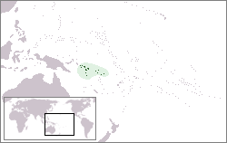
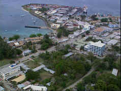
| − | '''Solomon Islands''' is a nation in | + | '''Solomon Islands''' is a nation in Melanesia, east of [[Papua New Guinea]]. It consists of more than 990 islands, which together cover a land mass of 28,400 square kilometres. Its capital is Honiara, which is located on the island of Guadalcanal. |
| − | The Solomon Islands have been inhabited by Melanesian people for at least 30,000 years. The [[United Kingdom]] established a protectorate over the Solomon Islands in the 1890s. Some of the bitterest fighting of World War II occurred on these islands. Self-government was achieved in 1976 and independence two years later. The country remains a | + | The Solomon Islands have been inhabited by Melanesian people for at least 30,000 years. The [[United Kingdom]] established a protectorate over the Solomon Islands in the 1890s. Some of the bitterest fighting of World War II occurred on these islands. Self-government was achieved in 1976 and independence two years later. The country remains a Commonwealth Realm. |
| − | Since 1997 ethnic violence, government misconduct and crime have undermined stability and civil society. In June 2003 an Australian-led multinational force the | + | Since 1997 ethnic violence, government misconduct and crime have undermined stability and civil society. In June 2003 an Australian-led multinational force the Regional Assistance Mission to the Solomon Islands (RAMSI) arrived to restore peace and disarm ethnic militias. |
== Geography == | == Geography == | ||
{{main|Geography of the Solomon Islands}} | {{main|Geography of the Solomon Islands}} | ||
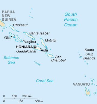
| − | Solomon Islands is a wide island nation that lies East of [[Papua New Guinea]] and consists of many islands: | + | Solomon Islands is a wide island nation that lies East of [[Papua New Guinea]] and consists of many islands: Choiseul, the Shortland Islands; the New Georgia Islands; Santa Isabel Island; the Russell Islands; Nggela (the Florida Islands); Malaita; Guadalcanal (Pacific Ocean island); Sikaiana; Maramasike; Ulawa; Uki; Makira (San Cristobal); Santa Ana; Rennell and Bellona; the Santa Cruz Islands and three remote, tiny outliers, Tikopia, Anuta, and Fataka. The distance between the westernmost and easternmost islands is about 1500km. The Santa Cruz Islands, north of [[Vanuatu]], (of which Tikopia is part) are especially isolated at more than 200km from the other islands. Bougainville is geographically part of the Solomon Islands, but politically [[Papua New Guinea]]. |
| − | The islands' ocean-equatorial climate is extremely humid throughout the year, with a mean temperature of | + | The islands' ocean-equatorial climate is extremely humid throughout the year, with a mean temperature of 27°C (80° F) and few extremes of temperature or weather. June through August is the cooler period. Though seasons are not pronounced, the northwesterly winds of November through April bring more frequent rainfall and occasional squalls or cyclones. The annual rainfall is about 305cm (120in.). |
| + | |||
| + | The Solomon Islands archipelago is part of two distinct terrestrial ecoregions. Most of the islands are part of the Solomon Islands rain forests ecoregion, which also includes the islands of Bougainville and Buka, which are part of [[Papua New Guinea]], these forests have come under pressure from forestry activities. The Santa Cruz Islands are part of the Vanuatu rain forests ecoregion, together with the neighboring archipelago of [[Vanuatu]]. Soil quality ranges from extremely rich volcanic, and there are volcanoes with varying degrees of activity are situated on some of the larger islands, to relatively infertile limestone. More than 230 varieties of orchids and other tropical flowers brighten the landscape. | ||
| + | |||
| + | |||
| + | <div style="float:right;margin:0 0 1em 1em;" align=right> | ||
| + | [[Image:SolomonIslandsMap.png]] | ||
| + | |||
| + | [[image:Solomon_Islands_and_Oceania.jpg|The location of the Solomon Islands in Oceania]] | ||
| + | </div> | ||
| + | |||
| + | ==Location== | ||
| + | |||
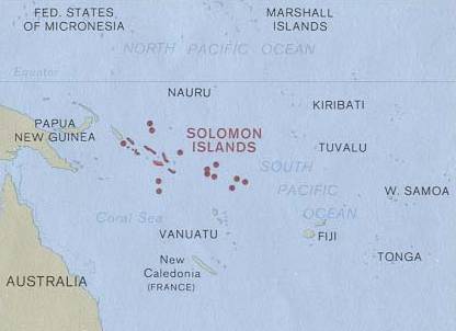
| + | The [[Solomon Islands]] are a wide island nation in the South [[Pacific Ocean]], that lies East of [[Papua New Guinea]] and consists of many islands: | ||
| + | [[Choiseul province|Choiseul]], the [[Shortland Islands]], the [[New Georgia Islands]], [[Santa Isabel Island|Santa Isabel]], the [[Russel Islands]], the [[Florida Islands]], [[Malaita]], [[Guadalcanal]], [[Sikaiana]], [[Maramasike]], [[Ulawa]], [[Uki]], [[San Cristobal (Solomon Islands)|San Cristobal]], [[Santa Ana]], [[Rennell]], [[Rennell and Bellona|Bellona]] and the [[Santa Cruz Islands]]. The distance between the most western and most eastern islands is about 1500 km. Especially the [[Santa Cruz Islands]], North of [[Vanuatu]], (of which [[Tikopia]] is part) are isolated at more than 200 km from the other islands. | ||
| + | |||
| + | [[Volcano]]es with varying degrees of activity are situated on some of the larger islands, while many of the smaller islands are simply tiny [[atoll]]s covered in sand and [[palm tree]]s. | ||
| + | |||
| + | [[Bougainville]] is geographically part of the Solomon Islands, but politically [[Papua New Guinea]]. | ||
| + | |||
| + | ==Climate== | ||
| + | |||
| + | The climate is [[tropical]], though temperatures are rarely extreme due to cooling winds blowing off the surrounding seas. Daytime temperatures are normally 25 to 32 [[Celsius]], falling about 3 to 5 at night. From April to October, the Southeast trade winds blow, gusting at times up to 30 knots or more. November to March is the wet season - the northwest [[monsoon]] - typically warmer and wetter. Cyclones arise in the Coral Sea and the area of the Solomon Islands, but they usually veer toward [[Vanuatu]] and [[New Caledonia]] or down the coast of [[Australia]]. | ||
| + | |||
| + | '''[[Geographic coordinates]]:''' {{coor dm|8|00|S|159|00|E|type:country}} | ||
| + | |||
| + | '''Map references:''' Oceania | ||
| + | |||
| + | '''Area:''' | ||
| + | <br>''total:'' | ||
| + | 28,450 km² | ||
| + | <br>''land:'' | ||
| + | 27,540 km² | ||
| + | <br>''water:'' | ||
| + | 910 km² | ||
| + | |||
| + | '''Area - comparative:''' Slightly smaller than the US state of [[Maryland]] | ||
| + | |||
| + | '''Land boundaries:''' 0 km | ||
| + | |||
| + | '''Coastline:''' 5,313 km | ||
| + | |||
| + | '''Maritime claims:''' | ||
| + | <br>Measured from claimed archipelagic baselines | ||
| + | <br>''continental shelf:'' | ||
| + | 200 nm | ||
| + | <br>''exclusive economic zone:'' | ||
| + | 200 nm | ||
| + | <br>''territorial sea:'' | ||
| + | 12 nm | ||
| + | |||
| + | '''Terrain:''' Mostly rugged mountains with some low coral atolls | ||
| + | |||
| + | '''Elevation extremes:''' | ||
| + | <br>''lowest point:'' | ||
| + | Pacific Ocean 0 m | ||
| + | <br>''highest point:'' | ||
| + | [[Mount Popomanaseu]] 2,332 m (not [[Mount Makarakomburu]]) | ||
| + | |||
| + | '''Natural resources:''' [[fish]], [[forest]]s, [[gold]], [[bauxite]], [[phosphate]]s, [[lead]], [[zinc]], [[nickel]] | ||
| + | |||
| + | '''Land use:''' | ||
| + | <br>''arable land:'' | ||
| + | 1% | ||
| + | <br>''permanent crops:'' | ||
| + | 1% | ||
| + | <br>''permanent pastures:'' | ||
| + | 1% | ||
| + | <br>''forests and woodland:'' | ||
| + | 88% | ||
| + | <br>''other:'' | ||
| + | 9% (1993 est.) | ||
| + | |||
| + | '''Irrigated land:''' NA km² | ||
| + | |||
| + | '''Natural hazards:''' [[Typhoon]]s, but they are rarely destructive; geologically active region with frequent earth tremors; [[volcanic]] activity | ||
| + | |||
| + | '''Environment - current issues:''' [[Deforestation]]; [[soil erosion]]; much of the surrounding [[coral reef]]s are dead or dying | ||
| + | |||
| + | '''Environment - international agreements:''' | ||
| + | <br>''party to:'' [[Biodiversity]], [[United Nations Framework Convention on Climate Change|Climate Change]], [[Desertification]], [[Environmental Modification]], [[Law of the Sea]], [[Marine Dumping]], [[Marine Life Conservation]], [[Ozone Layer Protection]], [[Whaling]] | ||
| + | <br>''signed, but not ratified:'' | ||
| + | Climate Change-[[Kyoto Protocol]] | ||
| − | |||
== History == | == History == | ||
Revision as of 23:02, 4 June 2006
| Solomon Islands | ||||||
|---|---|---|---|---|---|---|
|
||||||
| Motto: To Lead is to Serve | ||||||
| Anthem: God Save Our Solomon Islands Royal anthem: God Save the Queen |
||||||
| Capital (and largest city) | Honiara 9°28′S 159°49′E | |||||
| Official languages | English | |||||
| Government | Const. monarchy | |||||
| Independence | ||||||
| Area | ||||||
| - | Total | 28,450 km² (140th) sq mi |
||||
| - | Water (%) | 3.2% | ||||
| Population | ||||||
| - | July 2005 estimate | 478,000 (166th) | ||||
| GDP (PPP) | 2002 estimate | |||||
| - | Total | $800 million (200th) | ||||
| - | Per capita | $1,700 (2002 est.) (189th) | ||||
| Currency | Solomon Islands dollar (SBD) |
|||||
| Time zone | (UTC+11) | |||||
| Internet TLD | .sb | |||||
| Calling code | +677 | |||||
Solomon Islands is a nation in Melanesia, east of Papua New Guinea. It consists of more than 990 islands, which together cover a land mass of 28,400 square kilometres. Its capital is Honiara, which is located on the island of Guadalcanal.
The Solomon Islands have been inhabited by Melanesian people for at least 30,000 years. The United Kingdom established a protectorate over the Solomon Islands in the 1890s. Some of the bitterest fighting of World War II occurred on these islands. Self-government was achieved in 1976 and independence two years later. The country remains a Commonwealth Realm.
Since 1997 ethnic violence, government misconduct and crime have undermined stability and civil society. In June 2003 an Australian-led multinational force the Regional Assistance Mission to the Solomon Islands (RAMSI) arrived to restore peace and disarm ethnic militias.
Geography
Solomon Islands is a wide island nation that lies East of Papua New Guinea and consists of many islands: Choiseul, the Shortland Islands; the New Georgia Islands; Santa Isabel Island; the Russell Islands; Nggela (the Florida Islands); Malaita; Guadalcanal (Pacific Ocean island); Sikaiana; Maramasike; Ulawa; Uki; Makira (San Cristobal); Santa Ana; Rennell and Bellona; the Santa Cruz Islands and three remote, tiny outliers, Tikopia, Anuta, and Fataka. The distance between the westernmost and easternmost islands is about 1500km. The Santa Cruz Islands, north of Vanuatu, (of which Tikopia is part) are especially isolated at more than 200km from the other islands. Bougainville is geographically part of the Solomon Islands, but politically Papua New Guinea.
The islands' ocean-equatorial climate is extremely humid throughout the year, with a mean temperature of 27°C (80° F) and few extremes of temperature or weather. June through August is the cooler period. Though seasons are not pronounced, the northwesterly winds of November through April bring more frequent rainfall and occasional squalls or cyclones. The annual rainfall is about 305cm (120in.).
The Solomon Islands archipelago is part of two distinct terrestrial ecoregions. Most of the islands are part of the Solomon Islands rain forests ecoregion, which also includes the islands of Bougainville and Buka, which are part of Papua New Guinea, these forests have come under pressure from forestry activities. The Santa Cruz Islands are part of the Vanuatu rain forests ecoregion, together with the neighboring archipelago of Vanuatu. Soil quality ranges from extremely rich volcanic, and there are volcanoes with varying degrees of activity are situated on some of the larger islands, to relatively infertile limestone. More than 230 varieties of orchids and other tropical flowers brighten the landscape.
Location
The Solomon Islands are a wide island nation in the South Pacific Ocean, that lies East of Papua New Guinea and consists of many islands: Choiseul, the Shortland Islands, the New Georgia Islands, Santa Isabel, the Russel Islands, the Florida Islands, Malaita, Guadalcanal, Sikaiana, Maramasike, Ulawa, Uki, San Cristobal, Santa Ana, Rennell, Bellona and the Santa Cruz Islands. The distance between the most western and most eastern islands is about 1500 km. Especially the Santa Cruz Islands, North of Vanuatu, (of which Tikopia is part) are isolated at more than 200 km from the other islands.
Volcanoes with varying degrees of activity are situated on some of the larger islands, while many of the smaller islands are simply tiny atolls covered in sand and palm trees.
Bougainville is geographically part of the Solomon Islands, but politically Papua New Guinea.
Climate
The climate is tropical, though temperatures are rarely extreme due to cooling winds blowing off the surrounding seas. Daytime temperatures are normally 25 to 32 Celsius, falling about 3 to 5 at night. From April to October, the Southeast trade winds blow, gusting at times up to 30 knots or more. November to March is the wet season - the northwest monsoon - typically warmer and wetter. Cyclones arise in the Coral Sea and the area of the Solomon Islands, but they usually veer toward Vanuatu and New Caledonia or down the coast of Australia.
Geographic coordinates: 8°00′S 159°00′E
Map references: Oceania
Area:
total:
28,450 km²
land:
27,540 km²
water:
910 km²
Area - comparative: Slightly smaller than the US state of Maryland
Land boundaries: 0 km
Coastline: 5,313 km
Maritime claims:
Measured from claimed archipelagic baselines
continental shelf:
200 nm
exclusive economic zone:
200 nm
territorial sea:
12 nm
Terrain: Mostly rugged mountains with some low coral atolls
Elevation extremes:
lowest point:
Pacific Ocean 0 m
highest point:
Mount Popomanaseu 2,332 m (not Mount Makarakomburu)
Natural resources: fish, forests, gold, bauxite, phosphates, lead, zinc, nickel
Land use:
arable land:
1%
permanent crops:
1%
permanent pastures:
1%
forests and woodland:
88%
other:
9% (1993 est.)
Irrigated land: NA km²
Natural hazards: Typhoons, but they are rarely destructive; geologically active region with frequent earth tremors; volcanic activity
Environment - current issues: Deforestation; soil erosion; much of the surrounding coral reefs are dead or dying
Environment - international agreements:
party to: Biodiversity, Climate Change, Desertification, Environmental Modification, Law of the Sea, Marine Dumping, Marine Life Conservation, Ozone Layer Protection, Whaling
signed, but not ratified:
Climate Change-Kyoto Protocol
History
The Solomon Islands have been inhabited by Melanesians for over 30,000 years. Polynesian settlers began to arrive in 4,000 B.C.E. The first European to discover the islands was Pedro Sarmiento de Gamboa in 1568.Missionaries began visiting the Solomons in the mid-1800s. They made little progress at first, because "blackbirding"—the often brutal recruitment of laborers for the sugar plantations in Queensland and Fiji—led to a series of reprisals and massacres. The evils of the labor trade prompted the United Kingdom to declare a protectorate over the southern Solomons in 1893. In 1898 and 1899, more outlying islands were added to the protectorate; in 1900 the remainder of the archipelago, an area previously under German jurisdiction, was transferred to British administration. Under the protectorate, missionaries settled in the Solomons, converting most of the population to Christianity.
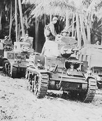
In the early 20th century, several British and Australian firms began large-scale coconut planting. Economic growth was slow, however, and the islanders benefited little. With the outbreak of World War II, most planters and traders were evacuated to Australia, and most cultivation ceased. Some of the most intense fighting of World War II occurred in the Solomons. The most significant of the Allied Forces' operations against the Japanese Empire Forces was launched on August 14 1942 with simultaneous naval bombardments and amphibious landings on the Florida Islands at Tulagi and Red Beach on Guadalcanal. The Battle of Guadalcanal became on of the most important battles fought in the Pacific.
Following the end of World War II, the British colonial government returned. The capital was moved from Tulagi to Honiara to take advantage of the infrastructure left behind by the U.S. military. A native movement known as the Marching Rule defied government authority. There was much disorder until some of the leaders were jailed in late 1948. Throughout the 1950s, other indigenous dissident groups appeared and disappeared without gaining strength. In 1960, an advisory council of Solomon Islanders was superseded by a legislative council, and an executive council was created as the protectorate's policymaking body. The council was given progressively more authority. In 1974, a new constitution was adopted establishing a parliamentary democracy and ministerial system of government. In mid-1975, the name Solomon Islands officially replaced that of British Solomon Islands Protectorate. On January 2, 1976, the Solomons became self-governing, and independence followed on July 7, 1978, the first post-independence government was elected in August 1980.
Following the 1997 election of Bartholomew Ulufa'alu the political situation in the Solomon's began to deteriorate. Governance was slipping as the performance of the police and other government agencies deteriorated due to ethnic rivalries. The capital of Honiara on Guadalcanal was increasingly populated by migrants from the island of Malaita. In June 2002, an insurrection mounted by militants from the island of Malaita resulted in the brief detention of Ulufa’alu and his subsequent forced resignation. Manasseh Sogavare, leader of the People's Progressive Party, was chosen Prime Minister by a loose coalition of parties. Guadalcanal militants retaliated and sought to drive Malaitan settlers from Guadalcanal, resulting in the closure of a large oil-palm estate and gold mine which were vital to exports. New elections in December 2001 brought Sir Allan Kemakeza into the Prime Minister’s chair with the support of a coalition of parties.
Kemakeza attempted to address the deteriorating law and order situation in the country, but the prevailing atmosphere of lawlessness, widespread extortion, and ineffective police, prompted a formal request by the Solomon Islands Government for outside help. With the country bankrupt and the capital in chaos, the request was unanimously supported in Parliament. In July 2003, Australian and Pacific Island police and troops arrived in the Solomon Islands under the auspices of the Australian-led Regional Assistance Mission to Solomon Islands (RAMSI). A sizable international security contingent of 2,200 police and troops, led by Australia and New Zealand, and with representatives from about 20 other Pacific nations began arriving the next month under Operation Helpem Fren. Since this time some commentators have considered the country a failed state.[1]
In April 2006 allegations that the newly elected Prime Minister Snyder Rini had used bribes from Chinese businessmen to buy the votes of members of Parliament led to mass rioting in the capital Honiara. A deep underlying resentment against the minority Chinese business community led to much of Chinatown in the city being destroyed. China sent chartered aircraft to evacuate hundreds of Chinese who fled to avoid the riots. Further Australian and New Zealand troops were dispatched to try to quell the unrest. Rini eventually resigned before facing a motion of no confidence in Parliament, and Parliament elected Manasseh Sogavare as Prime Minister.
Politics
The Solomon Islands are a constitutional monarchy and have a parliamentary system of government. The Queen is the head of state, she is represented by the Governor-General who is chosen by the Parliament for a 5-year term. There is a unicameral Parliament Parliament of 50 members, elected for 4-year terms. However, Parliament may be dissolved by majority vote of its members before the completion of its term. Parliamentary representation is based on single-member constituencies. Suffrage is universal for citizens over age 18. The head of government is the Prime Minister; the Prime Minister is elected by Parliament and chooses the other members of the cabinet. Each ministry is headed by a cabinet member, who is assisted by a permanent secretary, a career public servant, who directs the staff of the ministry.
Solomon Islands governments are characterized by weak political parties and highly unstable parliamentary coalitions. They are subject to frequent votes of no confidence, and government leadership changes frequently as a result. Cabinet changes are common.
Land ownership is reserved for Solomon Islanders. The law provides that resident expatriates, such as the Chinese and Kiribati, may obtain citizenship through naturalization. Land generally is still held on a family or village basis and may be handed down from mother or father according to local custom. The islanders are reluctant to provide land for nontraditional economic undertakings, and this has resulted in continual disputes over land ownership.
No military forces are maintained by the Solomon Islands, although the police force of nearly 500 includes a border protection element. The police also have responsibility for fire service, disaster relief, and maritime surveillance. The police force is headed by a commissioner, appointed by the Governor General and responsible to the prime minister. The current commissioner is an Australian funded by assistance.
Provinces
For local government, the country is divided into 10 administrative areas, of which nine are provinces administered by elected provincial assemblies, and the 10th is the town of Honiara, administered by the Honiara Town Council.
- Central
- Choiseul
- Guadalcanal
- Honiara, Town
- Isabel
- Makira-Ulawa
- Malaita
- Rennell and Bellona
- Temotu
- Western
Foreign relations
Solomon Islands is a member of the United Nations, Commonwealth, South Pacific Commission, South Pacific Forum, International Monetary Fund, and the European Economic Community/African, Caribbean, Pacific Group (EEC/ACP)/(Lome Convention).
The political stage of the Solomon Islands is further influenced by its diplomatic importance to China (PRC) and Taiwan (ROC). The Solomon Islands gives diplomatic recognition to the ROC, recognizing it as the sole-legitimate Government of all of China, giving Taiwan vital votes in the United Nations. Lucrative investments, political funding and preferential loans from both China and Taiwan are increasingly manipulating the political landscape of the Solomon Islands.
Relations with Papua New Guinea, which had become strained because of an influx of refugees from the Bougainville rebellion and attacks on the northern islands of the Solomon Islands by elements pursuing Bougainvillean rebels, have been repaired. A peace accord on Bougainville confirmed in 1998 has removed the armed threat, and the two nations regularized border operations in a 2004 agreement.
Economy
Its per capita GDP of $340 ranks Solomon Islands as a lesser developed nation, and more than 75% of its labor force is engaged in subsistence farming and fishing. Most manufactured goods and petroleum products must be imported. Until 1998, when world prices for tropical timber fell steeply, timber was Solomon Islands main export product, and, in recent years, Solomon Islands forests were dangerously overexploited. Other important cash crops and exports include copra and palm oil. In 1998 Ross Mining of Australia began producing gold at Gold Ridge on Guadalcanal. Minerals exploration in other areas continued. However in the wake of the ethnic violence in June 2000, exports of palm oil and gold ceased while exports of timber fell. The islands are rich in undeveloped mineral resources such as lead, zinc, nickel, and gold.
Exploitation of Solomon Islands' fisheries also offers prospects for export and domestic economic expansion. However, a Japanese joint venture, Solomon Taiyo Ltd., which operated the only fish cannery in the country, closed in mid-2000 as a result of the ethnic disturbances. Though the plant has reopened under local management, the export of tuna has not resumed. Negotiations are underway which may lead to the eventual reopening of the Gold Ridge mine and the major oil-palm plantation.
Tourism, particularly diving, is an important service industry for Solomon Islands. Growth in that industry is hampered, however, by lack of infrastructure and transportation limitations.
The Solomon Islands Government was insolvent by 2002. Since the RAMSI intervention in 2003, the government has recast its budget, and has taken a hard look at priorities. It has consolidated and renegotiated its domestic debt and with Australian backing, is now seeking to renegotiate its foreign obligations. Principal aid donors are Australia, New Zealand, the European Union, Japan, and the Republic of China.
Demographics
The majority 538,032 people on the Solomon Islands are ethnically Melanesian (94.5%), Polynesian (3%) and Micronesian (1.2%) are the two other significant groups.
There are 74 languges in the Solomon islands, 4 of those are extinct.[2] On the central islands, Melanesian languages are spoken, on the outliers Rennell and Bellona to the south, Tikopia, Anuta and Fataka to the far east, Sikaiana to the north east, and Luaniua (Ontong Java, Lord Howe Atoll) to the north, Polynesian languages. Immigrant populations of Gilbertese (i-Kiribati) and Tuvaluans speak Micronesian languages. While English is the official language but only 1-2% of the population speak English, the lingua franca is Solomons Pijin.
The religion of Solomon Islands is about 96% Christian (Anglican 45%, Roman Catholic 18%, United 12%, Baptist 10%, Seventh-day Adventist 7%, Other Christian 4%) and about 4% indigenous religious beliefs.
Culture
In the traditional culture of the Solomon Islands, age-old customs are handed down from one generation to the next, allegedly from the ancestral spirits themselves, to form the cultural values to Solomon Islands.
Radio is the most influential type of media in the Solomons Islands due to language differences and illiteracy,[3] the Solomon Islands Broadcasting Corporation (SIBC) operates public radio services, including the national stations Radio Happy Isles and Wantok FM, and the provincial stations Radio Happy Lagoon and Radio Temotu. There is one commercial station, Paoa RM, that broadcasts in the Solomons. There is one daily newspaper The press Solomon Star, 2 weekly papers Solomons Voice and Solomon Times, and 2 monthly papers Agrikalsa Nius and the Citizen's Press. There are no TV services based in the Solomon Islands, although satellite TV stations can be received.
See also: Music of the Solomon Islands
Credits
New World Encyclopedia writers and editors rewrote and completed the Wikipedia article in accordance with New World Encyclopedia standards. This article abides by terms of the Creative Commons CC-by-sa 3.0 License (CC-by-sa), which may be used and disseminated with proper attribution. Credit is due under the terms of this license that can reference both the New World Encyclopedia contributors and the selfless volunteer contributors of the Wikimedia Foundation. To cite this article click here for a list of acceptable citing formats.The history of earlier contributions by wikipedians is accessible to researchers here:
The history of this article since it was imported to New World Encyclopedia:
Note: Some restrictions may apply to use of individual images which are separately licensed.
- ↑ Solomon Is: Failed State or Not Failed State? October 29, 2003. Pacific Magazine URL Accessed 2006-05-04
- ↑ Gordon, Raymond G., Jr. (ed.), 2005. Solomon Islands in Ethnologue: Languages of the World, Fifteenth edition. Dallas, Tex.: SIL International
- ↑ BBC News. Country profile: Solomon Islands URL Accessed 2006-05-04

