Hanoi
File:Logo Hà Nội.jpg The Temple of Literature - Logo of Hanoi | |
| Name | |
| Name: | Hà Nội |
| Meaning: | River Interior |
| Founding Year: | 1010 |
| Geography | |
| Region: | Southeast Asia |
| Coordinates: | 21°2'N, 105°51'E (21.0333, 105.85) |
| Time Zone: | UTC +7 |
| Area: | 921 km² |
| File:LocationVietnamHaNoi.png | |
| People | |
| Population: | 3,145,300 (As of 2005 [1]) |
| Density: | 3,348/km² |
| Ethnicities: | Kinh |
| Calling Code: | +844 |
| ISO 3166-2 Code: | VN-64 |
| Website: | www.hanoi.gov.vn |
| Governance | |
| Administration Type: | Municipality |
| Council Chair: | |
| Committee Chair: | |
Hanoi (Vietnamese: Hà Nội, Hán Tự: 河内) pronunciation ▶, estimated population 3,145,300 (2005), is the capital of Vietnam. From 1010 until 1802, it was the political centre of an independent Vietnam with a few brief interruptions. It was eclipsed by Huế during the Nguyen Dynasty as the capital of Vietnam, but served as the capital of French Indochina from 1887 to 1954. From 1954 to 1976, after the victory of Viet Minh over France in the battle of Dien Bien Phu, it became the capital of North Vietnam.
The city is located on the right bank of the Red River. Hanoi is located at 21°2' North, 105°51' East, 1760 km (1094 mi) north of Ho Chi Minh City (formerly Saigon).[1]
History

The area around modern Hanoi has been inhabited since at least 3000 B.C.E. One of the first known permanent settlements is the Co Loa citadel founded around 200 B.C.E.
Hanoi has had many names throughout history, all of them of Sino-Vietnamese origin. During the Chinese domination of Vietnam, it was known as Tống Bình (宋平) and later Long Đỗ. In 866, it was turned into a citadel and was named Đại La (大羅).
In 1010, Lý Thái Tổ, the first ruler of the Lý Dynasty, moved the capital of Đại Việt (大越, the Great Viet, then the name of Vietnam) to the site of the Đại La Citadel. Claiming to have seen a dragon ascending the Red River, he renamed it Thăng Long (昇龍, Ascending dragon) - a name still used poetically to this day. It remained the capital of Vietnam until 1397, when the capital was moved to Thanh Hóa, also known as Tây Đô (西都, Western Capital). Thăng Long then became Đông Đô (東都, Eastern Capital).
In 1408, Vietnam was invaded by Chinese troops from the Ming Dynasty and Đông Đô was renamed Đông Quan (東關, Eastern Gateway) by the Chinese. In 1428, Vietnam was liberated from Chinese rule by Lê Lợi, the founder of the Le Dynasty and Đông Quan was renamed Đông Kinh (東京, Eastern Capital - the name known to Europeans as Tonkin; and evidently, the same characters used for Tokyo). During the Tây Sơn Dynasty, it was named Bắc Thành (北城, Northern Citadel). In 1802, when the Nguyễn Dynasty was established and then moved the capital down to present-day Huế, it was renamed Thăng Long (means "flying dragon"). However, the second syllable of the toponym is actually a homonym of the word long, and so, actually suggests “to flourish” as opposed to “dragon.” Therefore, the name would then have appeared as 昇隆, roughly to ascend and flourish. In 1831 the Nguyen Dynasty renamed it Hà Nội (河内, can be translated as Between Rivers or River Interior) . Hanoi was occupied by the French in 1873 and passed to them ten years later. It became the capital of French Indochina after 1887.
The city was occupied by the Japanese in 1940, and liberated in 1945, when it became the seat of Vietnam's government. From 1946 to 1954, it was the scene of heavy fighting between the French and Viet Minh forces. At that point, the city became the capital of an independent North Vietnam.
During the Vietnam War Hanoi's transportation facilities were disrupted by the bombing of bridges and railways, which were, however, promptly repaired. Following the end of the war, Hanoi became the capital of Vietnam when North and South Vietnam were reunited on July 2, 1976.
In 2004, a massive part of the 900 year old citadel was discovered in central Hanoi, near the site of Ba Dinh square.
Geography
Districts
Hanoi comprises nine inner districts of Ba Đình, Cầu Giấy, Đống Đa, Hoàn Kiếm, Hai Bà Trưng, Hoàng Mai, Long Biên, Tây Hồ and Thanh Xuân, and five outer districts of Đông Anh, Gia Lâm, Từ Liêm, Thanh Trì and Sóc Sơn.
Climate
Hanoi experiences the typical climate of northern Vietnam, where summers are hot and humid, and winters are relatively cool and dry. The summer months from May to September receive the majority of rainfall in the year (1,682 mm rainfall/ year). The winter months from November to March are relatively dry, although spring then often brings light rains. The minimum winter temperature in Hanoi can dip as low as 6–7°C (43°F) not including the wind chill, while summer can get as hot as 38–40 (100-104°F).[2]
Education

Hanoi, as the capital of French Indochina, was home to the first western-style universities in Indochina, including: Indochina Medical College (1902) - now Hanoi Medical University, Indochina University (1904) - now Hanoi National University, and École Supérieure des Beaux-Arts de L'Indochine (1925) - now Hanoi University of Fine Art.
After the communists took control of Hanoi in 1954, with support from Soviet Union, some new universities were built, among them, Hanoi University of Technology is still the largest technical university in Vietnam.
Hanoi is the largest centre of education in Vietnam. It is estimated that 62 % of the whole country science cadres are living and working in Hanoi.[3] Admissions to undergraduate study are through entrance examinations, which are conducted annually and open for everyone in the country. The majority of universities in Hanoi are public, although in recent years a few private universities have started their operation.
Because many of Vietnam's major universities are located in Hanoi, students from other provinces wishing to enter university often travel to Hanoi for the annual entrance examination. Such events often take place in June and July, for which a large number of students and their families converge on the city for a few weeks around this intense examination period. In recent years, these entrant exams have been centrally set by the ministry of education, but passmark is decided independently by each university.
Pre-tertiary schools in Hanoi mainly serve their local districts. Education is equivalent to the K–12 system in the US, with elementary school between grades 1 and 5, middle school (or junior high) between grades 6 and 9, and high school from grades 10 to 12.
Some pre-tertiary schools have selective classes for students with higher entry scores, with a stronger emphasis on subjects such as mathematics or sciences. In addition, some schools are designated as selective where admissions are via entrant examination on the subjects of specialization, often called School for Gifted students, such as Hanoi - Amsterdam High School. A few major universities in Hanoi also run a limited number of high-school and middle-school classes out of their Hanoi campuses for gifted students in subjects such as mathematics, chemistry, physics, information technology, linguistics, biology, and other social science and humanity subjects. These selective schools and classes, including HNUE High school, VNUH Gifted school of foreign languages, serve as a cradle for many of Vietnam's International Olympiad medal winners.
Places of interest

As the capital of Vietnam for almost a thousand years, Hanoi is considered to be the cultural centre of Vietnam, where every dynasty has left behind their imprint. Even though some relics have not survived through wars and time, the city still has many interesting cultural and historic monuments for visitors and residents alike.
Hanoi hosts more cultural sites than any city in Vietnam, including over 600 pagodas and temples.[4] Historians liken the life-giving Red River with its banks crowded with green rice paddies and farms to the Tigris and Euphrates rivers; a cradle of civilization. Even when the nation's capital moved to Hue under the Nguyen dynasty in 1802, the city of Hanoi continued to flourish, especially after the French took control in 1888 and modeled the city's architecture to their tastes, lending an important aesthetic to the city's rich stylistic heritage. The city boasts more than 1,000 years of history, and that of the past few hundred years has been well preserved.[5]
Under French rule, as an administrative centre for the French colony of Indochina, the French colonial architecture style became donminant, many examples remain today: the tree-lined boulevards (e.g Phan Dinh Phung street), The Grand Opera House, The State Bank of Vietnam (formerly The Bank of Indochina), The Presidential Palace (formerly Place of The Governor-General of French Indochina), The cathédrale St-Joseph, Hanoi University (formerly University of Indochina), historic hotel Sofitel Metropole...
Some others prominent places are: The Temple of Literature (Văn Miếu), site of the oldest university in Vietnam; One Pillar Pagoda (Chùa Một Cột); Flag Tower of Hanoi (Cột cờ Hà Nội); The Old Quarter and Hoàn Kiếm lake.
Hanoi is also home to a number of museums; including The Vietnamese National History Museum, The National Museum of Ethnology, The National Museum of Fine Arts and The Revolution Museum.
The Old Quarter, near Hoan Kiem lake, has the original street layout and architecture of old Hanoi. At the beginning of the 20th century the city consisted of only about 36 streets, most of which are now part of the old quarter. Each street then comprised of merchants and households specialized in a particular trade, such as silk traders, jewelery, etc. The street names nowadays still reflect these specializations, although few of them remain exclusively in their original commerce. The area is famous for its small artisans and merchants, including many silk shops. Local cuisine specialties as well as several clubs and bars can be found here also. A night market (near Đồng Xuân market) in the heart of the district opens for business every Friday, Saturday, and Sunday evening with a variety of clothing, souvenirs and food.
West Lake (Hồ Tây) is a popular place for people to spend time. It is the largest lake in Hanoi and there are many temples in the area. There are small boats for hire and a floating restaurant.
The spectacular Ban Gioc Waterfall is 272 km north of Hanoi and is popular for tourists.[6]
Population

Hanoi's population is constantly growing, a reflection of the fact that the city is both a major metropolitan area of Northern Vietnam, and also the country's political centre. This population growth also puts a lot of pressure onto the infrastructure, some of which is antiquated and dates back from the early 20th century.
Most people you meet in Hanoi these days are from different provinces all over the country. The number of Hanoians who settled down for more than three generations is likely to be very small as compared to the overall population of the city. Even in the Old Quarter, where commerce started hundreds years ago and was mostly a family business, many of the street-front stores nowadays are owned by merchants and retailers from other provinces. The original owner family may have either rented out the store and moved to live further inside the house, or just moved out of the neighbourhood altogether. The pace of change has especially escalated after the abandonment of central-planing economic policies, and the loosening of the district-based household registrar system.
The considerate and genteel nature of Hanoians is occasionally quoted in idioms and literature, which may appear as annoyingly snobbish. In reality, they are a reflection of a past where Hanoi is the convergent point for much of the country's talents in arts and education. They are also a reflection of a system heavily entrenched in Confucian values where modesty and consideration of others were regarded with a higher priority than one's self. As the opening up of the economy has brought in other pressures on people's daily life, advocates for traditional social and family values are in many ways helping to counter an "everyone for himself" mentality.
Transportation
Hanoi is served by Noi Bai International Airport, located in the Soc Son District, approximately 40 km (25 miles) north of Hanoi. Noi Bai is the only international airport for the northern regions of Vietnam. Direct daily flights are available to other cities in Vietnam, Asia, Australia, and Europe. Flights to and from the Americas usually involve a transit. The airport has recently been rebuilt with modern facilities.
There are two main highways linking the airport and city. The route to the city via Thang Long Bridge is more direct than Highway 1, which runs along the outskirts of the city. The main highways are shared by cars, motor scooters, with separate lanes by the side for bicycles. Taxis are plentiful and usually have trip meters, although it is also common to agree on the trip price before taking a taxi from airport to the city centre. Tourists also sometimes tour the city on Cyclos especially in the Old Quarter.
Hanoi is also the origin departure point for many train routes in the country. The Union Express (tàu Thống Nhất) runs from Hanoi to Ho Chi Minh City from Hanoi station (formerly Hang Co station), with stops at cities and provinces along the line. Trains also depart Hanoi frequently for Hai Phong and other northern cities.
The main means of transport within the city are motobikes, buses, taxis, and bicycles. Motobikes remain the most common way to move around the city, due to their flexibility in navigating small streets, lack of parking spaces for cars, and also being more fuel economic than automobiles. The number of private cars are however rising every year, and traffic at peak hours can be very heavy at main intersections.
Public buses run on many routes and fare can be purchased on the bus. For short trips, "xe ôm" (literally, "hug vehicle") motorcycle taxis are available where the passenger sits at the rear of a motobike and the driver will take you to your destination. A taxi is more convenient for longer trips, and if you do not wish to travel in open air.
Economy
Hanoi has the highest Human Development Index among the cities in Vietnam. Though representing only 3.6 percent of the country's population and 0.3 percent of the national territory, Hanoi contributes 8 percent to the national GDP and 45 percent of the Red River Delta's economy.
Industrial production in the city has experienced a rapid boom since the 1990s, with average annual growth of 19.1 percent from 1991–95, 15.9 percent from 1996–2000, and 20.9 percent during 2001–2003. In addition to eight existing industrial parks, Hanoi is building five new large-scale industrial parks and 16 small- and medium-sized industrial clusters. The non-state economic sector is expanding fast, with more than 25,000 businesses currently operating under the Enterprise Law.
Trade is another strong sector of the city. In 2003, Hanoi had 2,000 businesses engaged in foreign trade, having established ties with 161 countries and territories. The city's export value grew by an average 11.6 percent each year from 1996–2000 and 9.1 percent during 2001–2003. The economic structure also underwent important shifts, with tourism, finance, and banking now playing an increasingly important role.
Agriculture, previously a pillar in Hanoi's economy, has striven to reform itself, introducing new high-yield plant varieties and livestock, and applying modern farming techniques.
Together with economic growth, Hanoi's appearance has also changed significantly, especially in recent years. Infrastructure is constantly being upgraded, with new roads and an improved public transportation system. The rate of telephone users was 30 per 100 people in 2003. New urban areas are growing rapidly, with 1.5 million square metres of housing constructed during 1996–2000 and 1.3 million square metres built in 2003 alone.
Social services have been developed in both scale and quality. The public healthcare network has been strengthened, ensuring at least one doctor for each commune and ward. Thanks to these accomplishments, Hanoi has the highest development index in the country. Movements such as raising donations for poor people or promoting a "cultural lifestyle," have received support from local people and been maintained.
Health care and other facilities
Some medical facilities in Hanoi:
- Bach Mai Hospital
- Viet Duc Hospital
- Saint Paul Hospital
- 108 Hospital
- L'Hôpital Français De Hanoï
- Hanoi Dental Clinic
- Hanoi Family Medical Practice
- International SOS
- 19-8 Hospital
Photos of Hanoi
- Hanoi temple de la litterature.jpg
The Temple of Literature, called ' la pagode des corbeaux " under the French
- EOS 6341 raw.jpg
The Temple of Literature, steles with names of those successful at the imperial exams
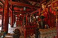
The Temple of Literature, main hall
- Van mieu 1.jpg
The Temple of Literature
- Chua mot cot.jpg
One Pillar Pagoda
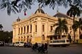
- Phu toan quyen 2.jpg
Presidential Palace, Hanoi (formerly Place of The Governor-General of French Indochina)
Grand Opera House
- Bacbophu.jpg
State Guest House (formerly Residence of Resident - Superior of Tonkin)
- Hanoi 4.jpg
Historic hotel Sofitel Metropole Hanoi
- Cot co.jpg
Flag Tower of Hanoi
- Chua tran quoc.jpg
Tran Quoc pagoda
- CathedraleSTJosephHanoi.jpg
The cathédrale St-Joseph
- Hanoi lythaito.jpg
Statue of Ly Thai To, founder of Hanoi
- EOS 6366 raw.jpg
Hoan Kiem lake
- Cau the huc.jpg
The Huc bridge and Hoan Kiem lake
- Pho co.jpg
The Old Quarter
- Pho kham thien.jpg
Kham Thien street, old days
- Pho phan dinh phung.jpg
Phan Dinh Phung street, former boulevard Carnot
- Bao tang my thuat.jpg
National Museum of Fine Art
- Bao tang lich su.jpg
National Museum of History
- Hilton hn.jpg
Hanoi tower (built on the land of the infamous prison Hanoi Hilton)
- Long bien bridge vn.jpg
Long Bien bridge
- Chieu ho tay.jpg
West Lake
- Pho trang tien.jpg
Trang Tien street, former rue Paul-Bert
- Le thai to str.jpg
A busy street
- Vietnam Hanoi HoChiMinhMausoleum.jpg
Ho Chi Minh mausoleum
- Chungcumoi dem.jpg
A new quarter
- Ha noi from nikko.jpg
Park of Reunification (former Lenin park)
- Sen hanoi.jpg
Selling lotus flowers in the street
- Hanoi-292.jpg
A French colonial-style house
- Pho hang hom.jpg
An old house (Pho Hang Hom)
- Pho19.jpg
Old street—A photo of a painting by Bui Xuan Phai—a famous Vietnamese painter


ReferencesISBN links support NWE through referral fees
- ↑ Country files (GNS). National Geospatial-Intelligence Agency. Retrieved 2007-04-06.
- ↑ Historical Weather for Hanoi, Vietnam. www.weatherbase.com.
- ↑ Hanoi - The capital of Vietnam: Preface. Hanoi City People's Committee.
- ↑ The quick look at Hanoi. Vietnam National Administration of Tourism.
- ↑ Introduction to Hanoi. The New York Times.
- ↑ Vietnam Destinations: Ban Gioc (Cao Bang). Retrieved 2007-02-12.
External links
- Official Site of Hanoi Government
- Hanoi: Yesterday and Today : Photos of Hanoi by amateurs
- Living in Hanoi: Expat and Travel guide
- Template:Vi icon Hanoi Corner : Forum of people who love Hanoi
- An article in New York Times about Hanoi
- Travel guide to Hanoi from Wikitravel
- New Hanoian Expat guide and message board
- Hoan Kiem lake photo gallery
- Interactive map of Hanoi: www.vinacarta.com, maps of South-East Asia
- Travel Photos Album of Hanoi
- Vietnam Museum of Etnology (Map: )
-
- Mapping from Multimap or GlobalGuide or Google Maps
- Satellite image from WikiMapia
- Mapping from OpenStreetMap
| |||||||

Template:Host Cities of the Francophonie Summits
Credits
New World Encyclopedia writers and editors rewrote and completed the Wikipedia article in accordance with New World Encyclopedia standards. This article abides by terms of the Creative Commons CC-by-sa 3.0 License (CC-by-sa), which may be used and disseminated with proper attribution. Credit is due under the terms of this license that can reference both the New World Encyclopedia contributors and the selfless volunteer contributors of the Wikimedia Foundation. To cite this article click here for a list of acceptable citing formats.The history of earlier contributions by wikipedians is accessible to researchers here:
The history of this article since it was imported to New World Encyclopedia:
Note: Some restrictions may apply to use of individual images which are separately licensed.