Difference between revisions of "Netherlands Antilles" - New World Encyclopedia
Mary Anglin (talk | contribs) m |
(→Geography: geography paragraph section done) |
||
| Line 59: | Line 59: | ||
==Geography== | ==Geography== | ||
| − | The windward islands are | + | The Netherlands Antilles, are made up of the islands of Curaçao, Bonaire, Saba, Saint Eustatius and Saint Martin, however, 6.3 miles of Saint Martin belongs to [[Guadeloupe]] on its side. Just like other islands lying in the [[Caribbean Sea]], the antilles have a tropical [[climate]], leaving them with warm weather all year round. The windward islands, which are composed of hilly volcanic origins which make it hard for [[agriculture]] there, are subject to hurricanes in the summer months. The leeward islands are also made up of volcanic origin but they are mixed of coral origins as well. The highest point of the islands is ''Mount Scenery'', 2,828 ft. (862 meters), located on Saba. The antilles consists of two island groupings, one (which includes Curaçao and Bonaire) lie just north of Venezuela, and the other grouping lies just to the east of both the [[U.S. Virgin Islands|U.S.]] and [[British Virgin Islands]]. |
| − | + | Geographically the antilles can be found at 12-15 N, 68-45 W; in terms of longitude and latitude. They have 596.5 miles² of land, 226 miles happen to be coastlines, with no major lakes or other major water sources. | |
| − | |||
| − | |||
| − | |||
| − | |||
| − | |||
| − | |||
'''Maritime claims:''' | '''Maritime claims:''' | ||
| Line 107: | Line 101: | ||
'''Natural hazards:''' | '''Natural hazards:''' | ||
| − | Curacao and Bonaire are south of Caribbean hurricane belt and are rarely threatened; | + | Curacao and Bonaire are south of Caribbean hurricane belt and are rarely threatened; Saint Martin, Saba, and Saint Eustatius are subject to hurricanes from July to October |
[[Image:Netherlands Antilles-CIA WFB Map.png|right|frame|Map of the Netherlands Antilles]] | [[Image:Netherlands Antilles-CIA WFB Map.png|right|frame|Map of the Netherlands Antilles]] | ||
Revision as of 21:58, 3 October 2007
| Nederlandse Antillen Antias Hulandes Netherlands Antilles |
||||||
|---|---|---|---|---|---|---|
|
||||||
| Motto: Libertate unanimus (Latin: "Unified by freedom") |
||||||
| Anthem: Anthem without a title |
||||||
 |
||||||
| Capital (and largest city) | Willemstad 12°7′N 68°56′W | |||||
| Official languages | Dutch, English, Papiamento | |||||
| Government | ||||||
| - | Monarch | Queen Beatrix | ||||
| - | Governor | Frits Goedgedrag | ||||
| - | Prime Minister | Emily de Jongh-Elhage | ||||
| constitutional monarchy | part of the Kingdom of the Netherlands | |||||
| Area | ||||||
| - | Total | 800 km² (184th) 309 sq mi |
||||
| - | Water (%) | Negligible | ||||
| Population | ||||||
| - | July 2005 estimate | 183,000 (185th) | ||||
| GDP (PPP) | 2003 estimate | |||||
| - | Total | $ 2.45 billion (180th) | ||||
| - | Per capita | $ 11,400 (2003 est.) (79th) | ||||
| Currency | Netherlands Antillean gulden (ANG) |
|||||
| Time zone | (UTC-4) | |||||
| Internet TLD | .an | |||||
| Calling code | +599 | |||||


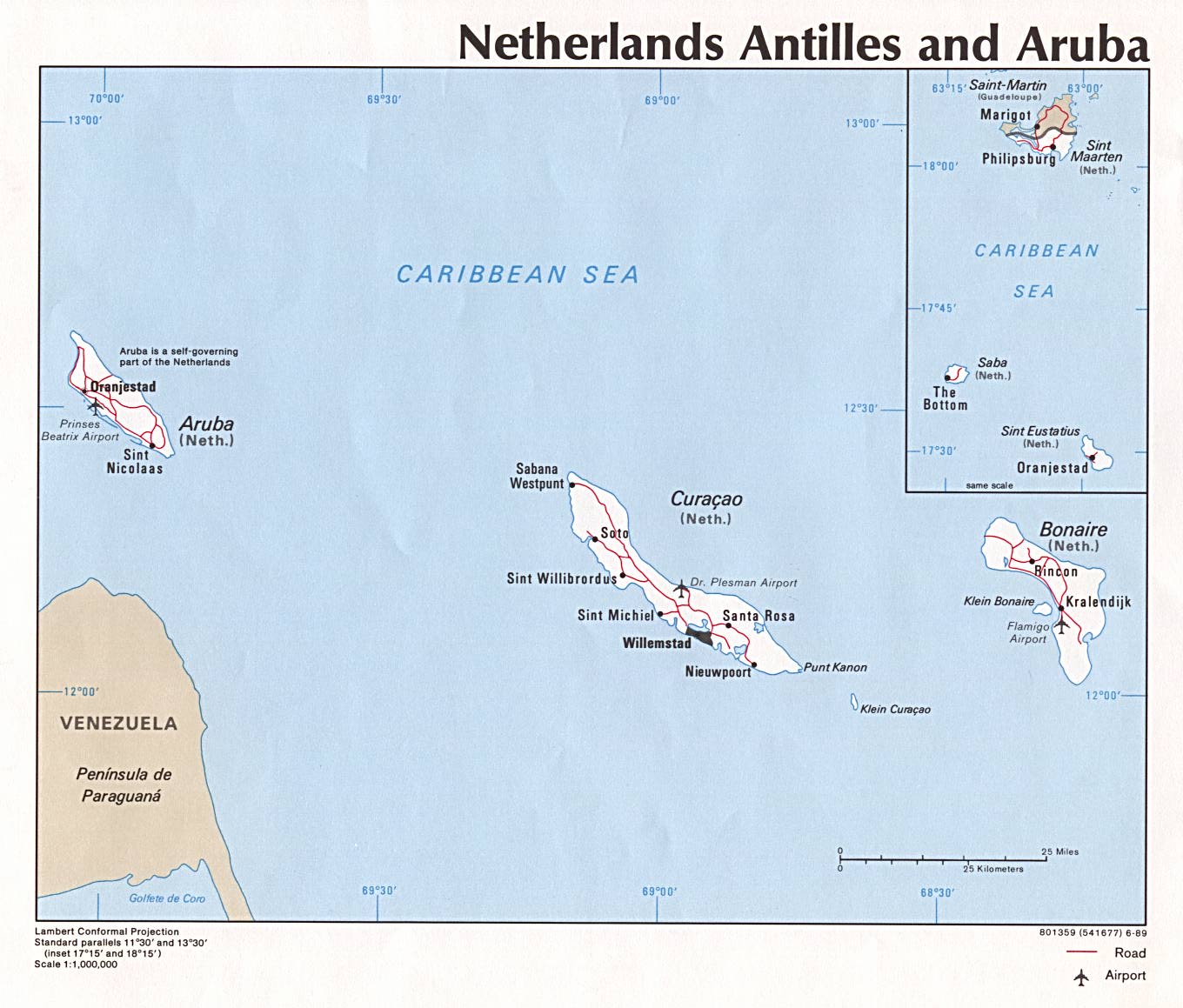
The Netherlands Antilles, previously known as the Netherlands West Indies or Dutch Antilles/West Indies, are part of the Lesser Antilles and consist of two groups of islands in the Caribbean Sea: Curaçao and Bonaire, just off the Venezuelan coast, and Sint Eustatius, Saba and Sint Maarten, located southeast of the Virgin Islands. The islands form an autonomous part of the Kingdom of the Netherlands. The islands' economy depends mostly upon tourism and petroleum.
Geography
The Netherlands Antilles, are made up of the islands of Curaçao, Bonaire, Saba, Saint Eustatius and Saint Martin, however, 6.3 miles of Saint Martin belongs to Guadeloupe on its side. Just like other islands lying in the Caribbean Sea, the antilles have a tropical climate, leaving them with warm weather all year round. The windward islands, which are composed of hilly volcanic origins which make it hard for agriculture there, are subject to hurricanes in the summer months. The leeward islands are also made up of volcanic origin but they are mixed of coral origins as well. The highest point of the islands is Mount Scenery, 2,828 ft. (862 meters), located on Saba. The antilles consists of two island groupings, one (which includes Curaçao and Bonaire) lie just north of Venezuela, and the other grouping lies just to the east of both the U.S. and British Virgin Islands.
Geographically the antilles can be found at 12-15 N, 68-45 W; in terms of longitude and latitude. They have 596.5 miles² of land, 226 miles happen to be coastlines, with no major lakes or other major water sources.
Maritime claims:
exclusive fishing zone:
12 nm
territorial sea:
12 nm
Climate: tropical; ameliorated by northeast trade winds
Terrain: generally hilly, volcanic interiors
Elevation extremes:
lowest point:
Caribbean Sea 0 m
highest point:
Mount Scenery 862 m
Natural resources: phosphates (Curacao only), salt (Bonaire only)
Land use:
arable land:
10%
permanent crops:
0%
permanent pastures:
0%
forests and woodland:
0%
other:
90% (1993 est.)
Irrigated land: NA km²
Natural hazards: Curacao and Bonaire are south of Caribbean hurricane belt and are rarely threatened; Saint Martin, Saba, and Saint Eustatius are subject to hurricanes from July to October

History
Both the leeward (Alonso de Ojeda, 1499) and windward (Christopher Columbus, 1493) island groups were discovered and initially settled by the Spanish. In the 17th century, the islands were conquered by the Dutch West India Company and were used as bases for the slave trade. Slavery was not abolished until 1863.
In 1954, the status of islands was promoted from that of a colonial territory to part of the Kingdom of the Netherlands as an associated state within a federacy. The island of Aruba was part of the Netherlands Antilles until 1986, when it was granted status aparte (i.e. it became a self-governing part of the Kingdom of the Netherlands).
Between June 2000 and April 2005, each island of the Netherlands Antilles had referendums on their future status. The four options that could be voted on were:
- closer ties with the Netherlands
- remaining within the Netherlands Antilles
- Autonomy as as country within the Kingdom of the Netherlands (status aparte)
- independence
Of the islands, Sint Maarten and Curaçao voted for status aparte. Saba and Bonaire voted for closer ties to the Netherlands. Sint Eustatius was the only island to vote to stay in the Netherlands Antilles.
The full results were:
On October 12, 2006, the Netherlands reached an agreement with Saba, Bonaire, and Sint Eustatius; this agreement would make these islands special municipalities.[1] On November 3, 2006, Curaçao and Sint Maarten were granted autonomy in an agreement,[2] but this agreement was rejected by Curaçao on November 28.[3] The Curaçao government was not sufficiently convinced that the agreement would provide enough autonomy for Curaçao. [4] On July 9, 2007 Curaçao approved the agreement it had rejected in November 2006.[5]
On February 12, 2007, an agreement was signed between the Netherlands and every island except Curaçao. This agreement would end the Netherlands Antilles by December 15, 2008 and make 1 billion guilders available for debt relief, social development and poverty reduction.[6]
Politics
The head of state is the ruling monarch of the Netherlands, who is represented in the Netherlands Antilles by a governor. The governor is also head of the local government, and forms, together with the council of ministers, the executive branch of the government.
The legislative branch is two-layered. Delegates of the islands are represented in the government of the Netherlands Antilles, but each island has its own government that takes care of the daily tasks on the island.
The Netherlands Antilles are not part of the European Union. Since 2006 the Islands have given rise to diplomatic disputes between Venezuela and the Netherlands. Venezuelan President Hugo Chávez claims that the Netherlands may allow the United States to install military bases that would be necessary for a planned U.S. invasion of Venezuela. On May 23, 2006 an international military manoeuver known as Joint Caribbean Lion 2006, including forces of the U.S. Navy, began.
Future status

The Netherlands Antilles is to be disbanded on December 15, 2008.[6] The idea of the Netherlands Antilles as a state never enjoyed full support of all islands. Political relations between islands were often strained. After a long struggle, Aruba seceded from the Netherlands Antilles in 1986, to form its own state within the Kingdom of the Netherlands. The desire for secession has also been strong in Sint Maarten.
In 2004 a commission of the governments of the Netherlands Antilles and the Netherlands reported on a future status for the Netherlands Antilles. The commission advised a revision of the Statute of the Kingdom of the Netherlands in order to dissolve the Netherlands Antilles.
Two new associated states within the Kingdom of the Netherlands would be formed, Curaçao and Sint Maarten. Meanwhile, Bonaire, Saba and Sint Eustatius would become a direct part of the Netherlands as special municipalities (bijzondere gemeente), a form of "public body" (openbaar lichaam) as outlined in article 134 of the Dutch Constitution. These municipalities will resemble ordinary Dutch municipalities in most ways (they will have a mayor, aldermen and a municipal council, for example) and will have to introduce most Dutch law. Residents of these three islands will also be able to vote in Dutch national and European elections. There are, however, some derogations for these islands. Social security, for example, will not be on the same level as it is in the Netherlands, and the islands are not obliged to introduce the euro; they may retain the Antillean guilder pending further negotiations. Also, it is unknown whether prostitution and same-sex marriage will become legal in these islands, which are legal on the mainland of the Netherlands. All five of the island territories may also continue to access the Common Court of Justice of Aruba and the Netherlands Antilles (with the Joint Court probably receiving a new name). The three islands will also have to involve the Dutch Minister of Foreign Relations before they can make agreements with countries in the region.
Originally the term used for Bonaire, Saba and St. Eustatius to describe their expected association with the Netherlands was "Kingdom Islands" (Koninkrijkseilanden). The Dutch province of North Holland has offered the three new municipalities to officially become part of the province.
Additionally, the Kingdom government would consist of the government of the Netherlands and one mandated minister per Caribbean country. The special municipalities would be represented in the Kingdom Government by the Netherlands, as they can vote for the Dutch parliament.
The Netherlands has proposed that the new EU constitution allow the Netherlands Antilles and Aruba to opt for the status of Outermost Region (OMR) also called Ultra Peripheral Region (UPR), if they wish.[7]
Islands
The Netherland Antilles have no major administrative divisions, although each island has its own local government.
The two island groups of which the Netherlands Antilles consists are:
- the "Leeward Islands" (Benedenwindse Eilanden), part of the Leeward Antilles island chain off the Venezuelan coast (along with Aruba):
- Bonaire, including an islet called Klein Bonaire ("Little Bonaire")
- Curaçao, including an islet called Klein Curaçao ("Little Curaçao")
- the "Windward Islands" (Bovenwindse Eilanden) east of Puerto Rico and the Virgin Islands. These are part of what are in English called the Leeward Islands, but in e.g. French, Spanish, German, Dutch and the English spoken locally these are considered part of the Windward Islands.
- Saba
- Sint Eustatius
- Sint Maarten, the southern half of the island Saint Martin (the northern half, Saint-Martin, is French and former part of the overseas department of Guadeloupe).
Economy
Tourism, petroleum transshipment and oil refinement (on Curaçao), as well as offshore finance are the mainstays of this small economy, which is closely tied to the outside world. The islands enjoy a high per capita income and a well-developed infrastructure as compared with other countries in the region. Almost all consumer and capital goods are imported, with Venezuela, the United States, and Mexico being the major suppliers, as well as the Dutch government which supports the islands with substantial development aid. Poor soils and inadequate water supplies hamper the development of agriculture. The Antillean guilder has a fixed exchange rate with the United States dollar of 1.79:1.
Demographics
A large part of the Netherlands Antilleans descends from European colonists and African slaves that were brought and traded here from the 17th to 19th century. The rest of the population originates from other Caribbean islands, Latin America, East Asia and elsewhere in the world.
Papiamentu is predominant on Curaçao and Bonaire (as well as the neighboring island of Aruba). This creole descends from Portuguese and West African languages with a strong admixture of Dutch, plus subsequent lexical contributions from Spanish and English.
After a decades-long debate, English and Papiamentu have been made official languages alongside Dutch in early March 2007. Legislation is produced in Dutch but parliamentary debate is in Papiamentu or English, depending on the island. Due to the islands' closeness to South America, Spanish is becoming increasingly known and used throughout the archipelago.
The majority of the population are followers of the Christian faith, mostly Roman Catholic. Curaçao also hosts a sizeable group of followers of the Jewish faith, descendants of a Portuguese group of Sephardic Jews that arrived from Amsterdam and Brazil in 1654.
Most Netherlands Antilleans are Dutch citizens and this status permits and encourages the young and university-educated to emigrate to the Netherlands. This exodus is considered to be to the islands' detriment as it creates a brain drain. On the other hand, immigrants from the Dominican Republic, Haiti, the Anglophone Caribbean and Colombia have increased their presence in the last years.
Culture
The origins of the population and location of the islands give the Netherlands Antilles a mixed culture.
Tourism and overwhelming media presence from the United States has increased the regional United States influence. On all the islands, the holiday of Carnival is, like in many Caribbean and Latin American countries, an important one. Festivities include "jump-up" parades with beautifully colored costumes, floats, and live bands as well as beauty contests and other competitions. Carnival on the islands also includes a middle-of-the-night j'ouvert (juvé) parade that ends at sunrise with the burning of a straw King Momo, cleansing the island of sins and bad luck. On Statia he is called Prince Stupid.
Notes
- ↑ Radio Netherlands (2006-10-12). Caribbean islands become Dutch municipalities. Retrieved 2007-02-02.
- ↑ Staff reporter. "Curaçao and St Maarten to have country status", Government.nl, 2006-11-03. Retrieved 2007-02-24. (written in english)
- ↑ Ministry of the Interior and Kingdom Relations (2006-11-29). Curacao rejects final agreement. Retrieved 2007-02-02.
- ↑ http://www.nu.nl/news/901903/11/Cura%E7ao_verwerpt_slotakkoord.html
- ↑ The Daily Herald St. Maarten (2007-07-09). Curaçao IC ratifies November 2 accord. Retrieved 2007-07-13.
- ↑ 6.0 6.1 Staff reporter. "Agreement on division of Netherlands Antilles", Government.nl, 2007-02-13. Retrieved 2007-02-24. (written in english)
- ↑ Economic Outlook Curaçao 2004 - Chapter 3.2 future relationship bewtwee EU, NL & NL Antilles
External links
- GOV.an - Main governmental site
- Central Bank of the Netherlands Antilles
- map
- Antillenhuis - Cabinet of the Netherlands Antilles' Plenipotentiary Minister in the Netherlands
- CIA World Factbook: Netherlands Antilles
- Antilles break-up closer
- Aruba on the internet - Dedicated to Aruba a part of the Netherlands
| ||||||||||||||||||||||||||
| Outlying territories of European countries | |
|---|---|
| Denmark | Greenland |
| France | Clipperton Island · French Guiana · French Polynesia · French Southern and Antarctic Lands (Amsterdam • Saint-Paul • Crozet • Kerguelen • Adélie Land1 • Scattered islands in the Indian Ocean: Bassas da India • Europa Island • Glorioso Islands • Juan de Nova Island • Tromelin Island) · Guadeloupe · Martinique · Mayotte · New Caledonia · Réunion · Saint-Barthélemy · Saint Martin · Saint Pierre and Miquelon · Wallis and Futuna |
| Italy | Pantelleria · Pelagie Islands (Lampedusa • Lampione • Linosa) |
| Netherlands | Aruba · Netherlands Antilles (Bonaire • Curaçao • Saba • Sint Maarten • Sint Eustatius) |
| Norway | Bouvet Island · Peter I Island1 · Queen Maud Land1 |
| Portugal | Azores · Madeira |
| Russia | Khabomai · Ratmanov Island · Shikotan |
| Spain | Canary Islands · Plazas de soberanía (Ceuta • Melilla) |
| United Kingdom | Anguilla · Ascension Island · Bermuda · British Virgin Islands · Cayman Islands · Falkland Islands · Montserrat · Saint Helena · Tristan da Cunha · Turks and Caicos Islands · British Antarctic Territory1 · British Indian Ocean Territory · Pitcairn Islands · South Georgia and the South Sandwich Islands |
|
| ||||||||||||||||||
Template:Countries and territories of Middle America
Template:Caricom
Credits
New World Encyclopedia writers and editors rewrote and completed the Wikipedia article in accordance with New World Encyclopedia standards. This article abides by terms of the Creative Commons CC-by-sa 3.0 License (CC-by-sa), which may be used and disseminated with proper attribution. Credit is due under the terms of this license that can reference both the New World Encyclopedia contributors and the selfless volunteer contributors of the Wikimedia Foundation. To cite this article click here for a list of acceptable citing formats.The history of earlier contributions by wikipedians is accessible to researchers here:
The history of this article since it was imported to New World Encyclopedia:
Note: Some restrictions may apply to use of individual images which are separately licensed.