Difference between revisions of "Namib Desert" - New World Encyclopedia
({{Contracted}}) |
Vicki Phelps (talk | contribs) |
||
| Line 1: | Line 1: | ||
{{Claimed}}{{Contracted}} | {{Claimed}}{{Contracted}} | ||
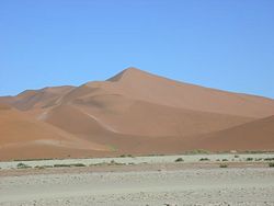
[[Image:Dune_7_in_the_Namib_Desert.jpeg|250px|thumb|Dune 7, the highest sand dune in the world (ca. 383 m.), in the Namib Desert, Namibia.]] | [[Image:Dune_7_in_the_Namib_Desert.jpeg|250px|thumb|Dune 7, the highest sand dune in the world (ca. 383 m.), in the Namib Desert, Namibia.]] | ||
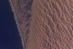
| − | [[Image:ConceptionBay Namibia ISS011-E-9756.jpg|thumb|250px|The | + | [[Image:ConceptionBay Namibia ISS011-E-9756.jpg|thumb|250px|The dune sea of the Namib Desert. Note how the crests of the dunes are aligned in a marked northwest-southeast orientation. These crests form transverse to the formative wind (i.e. crosswise). The dunes act as obstacles, and obstacles cause winds to be deflected significantly to the right, in the southern hemisphere—in effect reorienting the southerly wind as a southwesterly wind.]] |
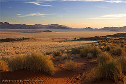
[[Image:NamibDesert01.jpg|250px|thumb|Sunset at the [[Namib Rand Nature Reserve]], Namibia.]] | [[Image:NamibDesert01.jpg|250px|thumb|Sunset at the [[Namib Rand Nature Reserve]], Namibia.]] | ||
| − | The '''Namib Desert''' is a [[desert]] in [[Namibia]] which forms part of the | + | The '''Namib Desert''' is a [[desert]] in [[Namibia]] which forms part of the Namib-Naukluft National Park, one of Africa's largest. The name "Namib" is from a word in Nama that means "immense." The desert occupies an area of around 1 E10 m²|50 000 km², stretching some 1,000 miles (1,600 km) along the [[Atlantic Ocean]] coast of Namibia, which is named after this desert. Its east-west width varies from 30 to 100 miles (50-160 km). The Namib Desert also reaches into southwest [[Angola]]. |
| − | The area is considered to be the oldest desert in the world, having endured [[arid]] or semi-arid conditions for at least | + | The area is considered to be the oldest desert in the world, having endured [[arid]] or semi-arid conditions for at least eighty million years. Its aridity is caused by the descent of dry air cooled by the cold Benguela current along the coast. It has less than 10 mm (0.4 inches) of rain annually and is almost completely barren. |
| − | A number of unusual [[species]] of [[plant]]s and [[animal]]s are found only in this desert. One of these is '' | + | A number of unusual [[species]] of [[plant]]s and [[animal]]s are found only in this desert. One of these is ''Welwitschia mirabilis'', one of the most unusual species. ''Welwitschia'' is a shrub-like plant but grows just two long, strap-shaped leaves continuously throughout its lifetime. These leaves may be several meters long, gnarled and twisted from the desert winds. The taproot of the plant develops into a flat, concave disc in age. ''Welwitschia'' is notable for its survival in the extremely arid conditions in the Namib, sometimes deriving moisture from the coastal sea fogs. Cold water meeting the hot desert is what creates the fog along the coast. |
| − | |||
| − | + | Although the desert is largely unpopulated and inaccessible, there are year-round settlements at Sesriem, close to Sossusvlei and a huge group of [[sand dune]]s, which at up to 340 meters high are the tallest sand dunes in the world. The complexity and regularity of dune patterns in its dune sea have attracted the attention of [[geologist]]s for decades; however, they remain poorly understood. | |
| − | + | Sossusvlei is a great dry clay marsh (“vlei”). In some years, during the rainy season the waters of the Tsauchab River arrived around Sossusvlei forming evocative pools of water at the feet of dunes. “Sossus” means “blind river” in the Nama language, so the literary translation of the word Sossusvlei is “marsh of the blind river”, that is “marsh of the river that does not have a mouth towards the sea”. | |
| − | Access is via light aircraft from | + | The interaction between the water-laden air coming from the sea via southerly [[wind]]s, some of the strongest of any coastal desert, and the dry air of the desert causes immense [[fog]]s and strong currents, causing sailors to lose their way. Along with the Skeleton Coast farther north, it is notorious as the site of many shipwrecks. Some of these wrecked ships can be found as much as 50 meters inland, as the desert is slowly creeping westward into the sea, reclaiming land over a period of many years. |
| + | |||
| + | The Namib is an important location for the mining of [[tungsten]], [[salt]], and [[diamond]]s. | ||
| + | |||
| + | Access is via light aircraft from Windhoek (the capital of Namibia, about 480 km east of the center of the desert), Swakopmund and Walvis Bay at the north end of the desert, or overland on gravel roads. | ||
== References == | == References == | ||
| Line 24: | Line 27: | ||
* [http://www.travelsaround.eu/eng/namibia/namibdesert/index.html Namib Desert photo gallery] | * [http://www.travelsaround.eu/eng/namibia/namibdesert/index.html Namib Desert photo gallery] | ||
| − | {{Deserts}} | + | {{Category:Deserts}} |
| − | |||
[[Category:Ecoregions]] | [[Category:Ecoregions]] | ||
| − | [[Category: | + | [[Category:Nations and places]] |
| − | + | [[Category:Africa]] | |
{{Link FA|uk}} | {{Link FA|uk}} | ||
| − | |||
| − | |||
| − | |||
| − | |||
| − | |||
| − | |||
| − | |||
| − | |||
| − | |||
| − | |||
| − | |||
| − | |||
| − | |||
| − | |||
| − | |||
| − | |||
| − | |||
| − | |||
| − | |||
| − | |||
| − | |||
| − | |||
| − | |||
| − | |||
| − | |||
{{credit|105519982}} | {{credit|105519982}} | ||
Revision as of 01:54, 17 March 2007

The Namib Desert is a desert in Namibia which forms part of the Namib-Naukluft National Park, one of Africa's largest. The name "Namib" is from a word in Nama that means "immense." The desert occupies an area of around 1 E10 m²|50 000 km², stretching some 1,000 miles (1,600 km) along the Atlantic Ocean coast of Namibia, which is named after this desert. Its east-west width varies from 30 to 100 miles (50-160 km). The Namib Desert also reaches into southwest Angola.
The area is considered to be the oldest desert in the world, having endured arid or semi-arid conditions for at least eighty million years. Its aridity is caused by the descent of dry air cooled by the cold Benguela current along the coast. It has less than 10 mm (0.4 inches) of rain annually and is almost completely barren.
A number of unusual species of plants and animals are found only in this desert. One of these is Welwitschia mirabilis, one of the most unusual species. Welwitschia is a shrub-like plant but grows just two long, strap-shaped leaves continuously throughout its lifetime. These leaves may be several meters long, gnarled and twisted from the desert winds. The taproot of the plant develops into a flat, concave disc in age. Welwitschia is notable for its survival in the extremely arid conditions in the Namib, sometimes deriving moisture from the coastal sea fogs. Cold water meeting the hot desert is what creates the fog along the coast.
Although the desert is largely unpopulated and inaccessible, there are year-round settlements at Sesriem, close to Sossusvlei and a huge group of sand dunes, which at up to 340 meters high are the tallest sand dunes in the world. The complexity and regularity of dune patterns in its dune sea have attracted the attention of geologists for decades; however, they remain poorly understood.
Sossusvlei is a great dry clay marsh (“vlei”). In some years, during the rainy season the waters of the Tsauchab River arrived around Sossusvlei forming evocative pools of water at the feet of dunes. “Sossus” means “blind river” in the Nama language, so the literary translation of the word Sossusvlei is “marsh of the blind river”, that is “marsh of the river that does not have a mouth towards the sea”.
The interaction between the water-laden air coming from the sea via southerly winds, some of the strongest of any coastal desert, and the dry air of the desert causes immense fogs and strong currents, causing sailors to lose their way. Along with the Skeleton Coast farther north, it is notorious as the site of many shipwrecks. Some of these wrecked ships can be found as much as 50 meters inland, as the desert is slowly creeping westward into the sea, reclaiming land over a period of many years.
The Namib is an important location for the mining of tungsten, salt, and diamonds.
Access is via light aircraft from Windhoek (the capital of Namibia, about 480 km east of the center of the desert), Swakopmund and Walvis Bay at the north end of the desert, or overland on gravel roads.
ReferencesISBN links support NWE through referral fees
- National Geographic, January 1992, pp. 54-85.
- Dune Patterns, Namib Desert, Namibia. NASA Earth Observatory. Retrieved 2006-05-05.
- Namib Naukluft Park photo gallery
- Namib Desert photo gallery
| Deserts |
|---|
| Ad-Dahna | Alvord | Arabian | Aral Karakum | Atacama | Baja California | Barsuki | Betpak-Dala | Chalbi | Chihuahuan | Dasht-e Kavir | Dasht-e Lut | Dasht-e Margoh | Dasht-e Naomid | Gibson | Gobi | Great Basin | Great Sandy Desert | Great Victoria Desert | Kalahari | Karakum | Kyzylkum | Little Sandy Desert | Mojave | Namib | Nefud | Negev | Nubian | Ordos | Owyhee | Qaidam | Registan | Rub' al Khali | Ryn-Peski | Sahara | Saryesik-Atyrau | Sechura | Simpson | Sonoran | Strzelecki | Syrian | Taklamakan | Tanami | Thar | Tihamah | Ustyurt |
Credits
New World Encyclopedia writers and editors rewrote and completed the Wikipedia article in accordance with New World Encyclopedia standards. This article abides by terms of the Creative Commons CC-by-sa 3.0 License (CC-by-sa), which may be used and disseminated with proper attribution. Credit is due under the terms of this license that can reference both the New World Encyclopedia contributors and the selfless volunteer contributors of the Wikimedia Foundation. To cite this article click here for a list of acceptable citing formats.The history of earlier contributions by wikipedians is accessible to researchers here:
The history of this article since it was imported to New World Encyclopedia:
Note: Some restrictions may apply to use of individual images which are separately licensed.

