Difference between revisions of "Everglades" - New World Encyclopedia
Mary Anglin (talk | contribs) (re organized) |
({{Contracted}}) |
||
| Line 1: | Line 1: | ||
| − | {{Claimed}} | + | {{Claimed}}{{Contracted}} |
[[Image:Everglades ecoregion.jpg|right|thumb|300px|Map of the Everglades ecoregion as delineated by the [[World Wide Fund for Nature|WWF]]. Satellite image from [[NASA]]. The yellow line encloses two ecoregions, the "Everglades" and the "South Florida rocklands." The South Florida rocklands ecoregion includes the Florida Keys and offshore islands and two patches within the Everglades.]] | [[Image:Everglades ecoregion.jpg|right|thumb|300px|Map of the Everglades ecoregion as delineated by the [[World Wide Fund for Nature|WWF]]. Satellite image from [[NASA]]. The yellow line encloses two ecoregions, the "Everglades" and the "South Florida rocklands." The South Florida rocklands ecoregion includes the Florida Keys and offshore islands and two patches within the Everglades.]] | ||
Revision as of 15:21, 11 June 2007

The Florida Everglades are subtropical marshland located in the southern portion of the U.S. state of Florida, specifically in parts of Monroe, Collier, Palm Beach, Miami-Dade, and Broward counties.
Though much modified by agricultural development in central and southern Florida, the Everglades is the southern half of a large watershed arising in the vicinity of Orlando known as the Kissimmee River system. The Kissimmee flows from Taylor Creek, Nubbin Slough, and Fisheating Creek, and discharges into Lake Okeechobee, a very large (730 mi² or 1,890 km²), shallow (10 ft or 3 m) fresh water lake. Water leaving Lake Okeechobee in the wet season forms the Everglades, a shallow, slow-moving flood at one time 40 miles wide and over 100 miles long moving southward across a nearly flat, limestone shelf to Florida Bay at the southern end of the state.
The Everglades extends from Lake Okeechobee on the north to Florida Bay on the south and was once bordered by Big Cypress Swamp on the west and the Atlantic Coastal Ridge on the east. It has been called River of Grass (Douglas, 1947) because of the slow flow of water from Okeechobee southward and the predominance of a sedge known as sawgrass. Slighty elevated points in this extremely flat area are covered with trees, usually cypress and red mangrove.
Some 50 percent of the original Everglades has been lost to agriculture. Most of the rest is now protected in a national park, national wildlife refuge, and water conservation areas. Water from the Everglades is still used as a water supply for major cities in the area, such as Miami. The Everglades is crossed from west to east by a toll road called "Alligator Alley," now part of Interstate 75.
There are several small outlets, such as the Miami River and the New River on the east and the Shark River on the southwest. There is a general south to southwesterly movement of surface water.
Encroachment
The publication in 1947 of Marjory Stoneman Douglas' Everglades: River of Grass was as electrifying an event among naturalists as Rachel Carson's Silent Spring. It drew attention to the vast area that makes South Florida habitable but was being treated by agricultural interests and housing developers as a worthless swamp that the U.S. Army Corps of Engineers would profitably be able to drain. It galvanized President Harry S. Truman's executive order later that year to protect more than 2 million acres (8,000km²) as Everglades National Park.

The strength of Mrs. Douglas's name was such that when legislation designed by lawyers representing the sugar growers' industry proposed to suspend all water quality standards in the Everglades for twelve years, it was named the Marjory Stoneman Douglas Act—until the 103-year old author demanded that her name be removed from the pending bill. It still passed in 1994, renamed the Everglades Forever Act, and was amended in 2003.
A settlement agreement between the federal government and the State of Florida, and approved by Judge William Hoeveler, imposed a plan to reduce damaging phosphorus levels in the Loxahatchee National Wildlife Refuge and Everglades National Park by December 31, 2006. Additionally, in 2004 the State of Florida adopted a 10 parts per billion numeric criteria for phosphorus within the Everglades Protection Area, which is comprised of the Loxahatchee National Wildlife Refuge, Everglades National Park, and Water Conservation Areas 2 and 3. The excessive phosphorus derives primarily from fertilizer used by sugarcane growers and other agricultural operations as well as construction runoff from the development of coastal areas such as Palm Beach County. Although the vast majority of the Everglades Protection Area currently meets water quality standards, approximately 10% of the area remain severely impacted. The State of Florida and the Army Corps of Engineers are undertaking various projects costing billions of dollars under the Comprehensive Everglades Restoration Plan to help ensure the proper quantity, quality, timing and distribution of waters to the Everglades and all of South Florida. Numerous lawsuits affecting Everglades restoration are pending before the courts.
Non-native/Invasive species

The Everglades also face an ongoing threat from the melaleuca tree (Melaleuca quinquenervia). Sprinkled from airplanes using salt and pepper shakers, the tiny seeds of the thirsty tree were intended to suck up the water and make the "land" of the Everglades suitable for development. The tree remains an invasive nuisance. Additionally, the oils in the trees are highly flammable, which could increase danger from wildfires.
Brazilian Pepper (Florida Holly) has also wreaked havoc on the Everglades, exhibiting a tendency to spread rapidly and crowd out native species. It is especially difficult to eradicate and is readily propagated by birds, which eat its small red berries. The Brazilian Pepper problem is not exclusive to the Everglades; however, neither is the Water Hyacinth, which is a widespread problem in Florida's waterways and a major threat to endemic species, and is also difficult and costly to eradicate.
Native to southern Asia, the Burmese python, Python molurus bivittatus is a relatively new invasive species in the Everglades. This large snake's population growth is due entirely to the indiscriminate pet trade, a growing cause of invasive species in the United States. Florida wildlife officials speculate that local or nearby states' residents have released their pet pythons after discovering that the snake has become too large to keep (record length in captivity: 27 feet). The Everglades habitat is perfect for bivittatus, and this species is said to be reproducing rapidly. There have been at least four recorded encounters between alligators and this large snake. [[1]]
Everglades National Park
| Everglades National Park | |
|---|---|
| IUCN Category Ib (Wilderness Area) | |
 | |
| Location: | Florida, USA |
| Nearest city: | Florida City, FL |
| Area: | 1,508,571 acres (6,104 km²) 1,494,970 acres (6,049 km²) federal |
| Established: | December 6, 1947 |
| Visitation: | 1,281,243 (in 2005) |
| Governing body: | National Park Service |
Everglades National Park preserves the southern portion of the Everglades (all south of Tamiami Trail), but represents only 20 % of the original wetland area. The Park covers 2,357 mi² (6,105 km²) and is a World Heritage Site. The only highway access to the main part is State Road 9336 and its extension in the park, running 38 miles (61 km) from Florida City to the coast at Flamingo. Excluding the main visitor center and some smaller park facilities, there is no development in the park; this 1,296,500 acre (5,246 km²) area has been designated the Marjory Stoneman Douglas Wilderness.
The area was authorized as a national park on May 30, 1934, but it was not fully established until December 6, 1947. The park was designated an International Biosphere Reserve on October 26, 1976. On November 10, 1978, most of the park was declared a wilderness area. Wilderness designations covered 1,296,505 acres (5247 km²) in 2003 — about 86 % of the park. It was listed as a UNESCO World Heritage Site on October 24, 1979 and as a Wetland of International Importance on June 4, 1987. However, in 1993 it was placed on the List of World Heritage Sites in danger.
There are a number of car parks and trails within the Park, of which the most famous is the Anhinga Trail. This trail allows very close approach to birds such as herons and anhinga. The latter birds often perch on the rails of the boardwalk. The park has mosquitos year-round, and they can be a major problem in the summer, even with mosquito repellant.
In October 2005, Hurricane Wilma came across the tip of Florida and had devastating effects on the park. Heavy damage was sustained at the Flamingo area of the park. The visitor center, lodge, restaurant, and marina store were shut down, with the area closed off to all visitors not escorted by a park ranger. As of March 14, 2006 the Marina Store, Visitor Center, and boat ramps are now open. The Lodge, Flamingo Restaurant, and Buttonwood Cafe still remain closed. Updates can be found on the Everglades National Park website.
Park Geography
Everglades National Park is surrounded by the urban and agricultural areas of Miami, Homestead, and Florida City to its east, the Florida Straits and Florida Keys to its south, the Gulf of Mexico to its west and Big Cypress National Preserve to its north. Big Cypress is similar to the northern portion of the Everglades and it is about half the size of the park itself. At the southwestern shore of the park is Ingraham Lake, the southernmost lake in the United States.
In the southeastern section of the park is the Earnest F. Coe Visitor Center, the park headquarters. It is located just to the west of Homestead and Florida City on state road 9336. Four miles to the west of the headquarters is the Royal Palm Visitor center. The general area of Royal Palm and the headquarters is nestled in a pineland area, as are the Hidden Lake Education and Daniel Beard Centers a few miles to the west. The large Taylor Slough runs from Royal Palm to Florida Bay. To the west of Royal Palm is also Long Pine Key. Long Pine Key (which is not actually an island) is located about four miles from Royal Palm on 9336 and is a prominent camping area in the forest like pineland area. Another four miles to the west on 9336 is the Pahayokee Overlook, which is a raised observation platform that overlooks the park to the north.
Continuing south, 9336 runs through a large cypress swamp. Just on the outside edge of this swamp is Mahogany Hammock, a trail located twenty miles from the headquarters, deep in the park. Even farther south, one comes into the coastal mangrove swamps. Hidden in the thousands of mangrove trees are hundreds of small lakes bay and rivers that empty into the Florida Straits. The swampy estuaries in this area are the only place in the U.S., where crocodiles can be found, although they are very rare. Also in these areas are manatees, which are often spotted at the surface on cool autumn mornings. At the very end of 9336 is the Flamingo Visitor Center, the farthest south visitor center in the park. It is located on the arid coastal prairie and lies just to the north of Florida Bay. Trails leading from Flamingo go west onto Cape Sable a cape in the extreme southwestern part of Florida. Also leading from Flamingo is the 99 mile Wilderness Waterway, a canoe trip from Flamingo in the south to the Gulf Coast Visitor Center in the north. The Gulf Coast Visitor Center serves as a visitor center for both the northwestern part of the everglades and the neighboring Big Cypress National Preserve.
In the northern section of the park, the most prominent area is the Shark Valley Visitor Center. A tram road which starts and ends at this center extends about seven miles from the northeastern border of the park into the Shark River Slough, an extensive freshwater slough that flows from Lake Okeechobee (north of the park) to the southwestern coast of Florida. The Shark River Slough is dotted with hundreds of small, jungle-like hardwood hammocks, which are home to many of the Everglades mammals and raptors.
The general Shark Valley area is perhaps what most visitors think of when they think of the everglades, as it is surrounded by a seemingly eternity of sawgrass in all directions. Alligators and wading birds often come within feet of visitors, and occasionally, a lazy alligator will block the road. At the point in the Shark Valley tram road where it turns back north there is the Shark Valley Observation Tower, a sixty five foot tower that overlooks the sawgrass prairie to the south.
Flora
The soil of the islands is very fertile and is subject to frequent inundation, but gradually the water area is being replaced by land. The vegetation is luxuriant, the live oak, wild lemon, wild orange, cucumber, pawpaw, custard-apple and wild rubber trees being among the indigenous species; there are, besides, many varieties of wild flowers, the orchids being especially noteworthy. There are two seasons, wet and dry, but the climate is equable.
Fauna
Specialties of the park include the Short-tailed Hawk and Smooth-billed Ani, and the Caribbean Flamingo at its only regular North American mainland site, usually near the town of Flamingo. Other wading birds such as herons, egrets, Wood Stork, Roseate Spoonbill and ibises are abundant. Limpkins can also be found in the Everglades.
The raptors include the rare Snail Kite and the very common Red-shouldered Hawk and Osprey.
From Flamingo, the water and mud flats of Florida Bay allow views of pelicans, shorebirds, terns and skimmers.
The waterways are inhabited by otters, manatees, alligators and crocodiles. The park is the only place in the world where alligators and crocodiles coexist naturally. Also deer and the severely endangered Florida panther are found.
- Littleblueheronsmall.jpg
A little blue heron hunting near water on Anhinga Trail.
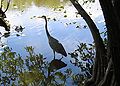
A great blue heron wading in a pond near Shark Valley.

PATTY, THESE 4 PARAGRAPHS ARE PROBABLY A SUMMARY OF THE ABOVE SEVERAL. MIGHT TAKE A LITTLE WORK TO MAKE THINGS FLOW. PLEASE DELETE REDUNDANCY. Everglades National Park preserves the southern portion of the Everglades (all south of Tamiami Trail), but represents only 27.3% of the original area. The Park covers 2.3 million acres (6,593km²) and is a World Heritage Site. The only highway access is the State Road 9336, running 47 miles (73km) from Florida City to the coast at Flamingo. There have been recent expansions to the park's tourist facilities to bring in more money to Florida's economy such as a massive extension to the visiting center, many outposts along the bridges that span the Everglades that teach people about the many birds and other wildlife native to the Everglades as well as a small petting zoo.
For much of its history, systematic exploration of the Everglades was prevented by the dense growth of sawgrass (Cladium jamaicense), a sedge with very sharp saw-toothed leaves. The first European to enter the region was Escalente de Fontenada, a Spanish captive of a Native American chief, who named a lake, Laguno del Espiritu Santo, and some islands, Cayos del Espiritu Santo. Between 1841 and 1856 various United States military forces penetrated the Everglades for the purpose of attacking and driving out the Seminoles, who took refuge here. The most important explorations during the later years of the 19th century were those of Major Archie P. Williams in 1883, James E. Ingraham in 1892, and Hugh L. Willoughby in 1897. The Seminoles were then practically the only inhabitants.
In 1850 under the Arkansas Bill, or Swamp and Overflow Act, practically all of the Everglades, which the state had been urging the federal government to drain and reclaim, were turned over to the state for that purpose, with the provision that all proceeds from such lands be applied to their reclamation. A board of trustees for the Internal Improvement Fund, created in 1855 and having as members ex officio the governor, comptroller, treasurer, attorney-general and commissioner-general, sold and allowed to railway companies much of the grant. Between 1881 and 1896 a private company owning 4,000,000 acres (16,000 km²) of the Everglades attempted to dig a canal from Lake Okeechobee through Lake Hicpochee and along the Caloosahatchee River to the Gulf of Mexico; the canal was closed in 1902 by overflows. Six canals were begun under state control in 1905 from the lake to the Atlantic, the northernmost at Jensen, the southernmost at Ft. Lauderdale; the total cost, estimated at $1,035,000 for the reclamation of 12,500 m², was raised by a drainage tax, not to exceed ten cents per acre ($24.71/km²), levied by the trustees of the Internal Improvement Fund and Board of Drainage commissioners.
The small area reclaimed by prior to that year (1905) was found very fertile and particularly adapted to raising sugar cane, oranges and garden vegetables.
External links
- Water's Journey: Everglades - Comprehensive film and web documentary about the Florida Everglades
- Everglades National Park (National Park Service)
- The Everglades in the Time of Marjorie Stoneman Douglas Photo exhibit created by the State Archives of Florida
- The Comprehensive Everglades Restoration Plan (CERP)
- ACCELER8 (Everglades Restoration)
- 'Judas snakes' plan to remove pythons from the Everglades
- Friends of the Everglades
- Everglades National Park
- Florida Everglades
- Overview of the Everglades' condition on its 50th anniversary, 1997.
- Arthur R. Marshall National Wildlife Refuge (US Fish & Wildlife Service)
- Photos of Everglades National Park - Terra Galleria
- Everglades images at bioimages.vanderbilt.edu (Slow modem version)
- South Florida Environmental Report (South Florida Water Management District and Florida DEP)
- Scientific American Magazine (May 2006) The End of the Everglades? Supreme court case jeopardizes 90 percent of U.S. wetland.
- Official Florida Everglades Tourism Information
- World Wide Fund for Nature - Everglades ecoregion
- World Wide Fund for Nature - South Florida rocklands ecoregion
- Official site: Everglades National Park
- The Everglades in the Time of Marjorie Stoneman Douglas Photo exhibit created by the State Archives of Florida
- Everglades National Park
- The Comprehensive Everglades Restoration Plan (CERP)
- UNESCO World Heritage Centre
- Marjory Stoneman Douglas Wilderness
ReferencesISBN links support NWE through referral fees
- Douglas, Marjory S. 1947. Everglades: River of Grass. (A revised edition was published in 1988 by Pineapple Press, Sarasota, Fl.)
- Lodge, Thomas E. 1994. The Everglades Handbook. Understanding the Ecosystem. CRC Press 228 p. ISBN 1-884015-06-9
- This article incorporates text from the Encyclopædia Britannica Eleventh Edition, a publication now in the public domain.
Rivers: Apalachicola · Caloosahatchee · Kissimmee · Ochlockonee · Peace · St. Johns · Suwannee · Withlacoochee · Yellow
Lakes: Apopka · Blue Cypress · East Toho · George · Harris · Istokpoga · Jackson · Jesup · Kissimmee · Miccosukee · Monroe · Okeechobee · Rodman · Rousseau · Seminole · Talquin · Toho · Tsala Apopka · Washington
Other Rivers: Alafia · Alapaha · Anclote · Aucilla · Blackwater · Chipola · Choctawhatchee · Econfina · Econlockhatchee · Escambia · Hillsborough · Ichetucknee · Little Manatee · Manatee · Miami · Myakka · Ocklawaha · Perdido · Pithlachascotee · Rainbow · St. Lucie · St. Marks · St. Marys · Santa Fe · Shark · Steinhatchee · Tomoka · Trout · Wakulla · Weeki Wachee · Wekiva · Withlacoochee
Canals: Cross Florida Barge Canal · Hillsboro Canal · Miami Canal · Okeechobee Waterway · Tamiami Canal
See Also: Florida Everglades · Intracoastal Waterway · List of Florida rivers
Credits
New World Encyclopedia writers and editors rewrote and completed the Wikipedia article in accordance with New World Encyclopedia standards. This article abides by terms of the Creative Commons CC-by-sa 3.0 License (CC-by-sa), which may be used and disseminated with proper attribution. Credit is due under the terms of this license that can reference both the New World Encyclopedia contributors and the selfless volunteer contributors of the Wikimedia Foundation. To cite this article click here for a list of acceptable citing formats.The history of earlier contributions by wikipedians is accessible to researchers here:
The history of this article since it was imported to New World Encyclopedia:
Note: Some restrictions may apply to use of individual images which are separately licensed.