Difference between revisions of "La Paz" - New World Encyclopedia
(fixed notes) |
(article ready, images ok) |
||
| Line 1: | Line 1: | ||
| − | + | {{images OK}} | |
| + | {{ready}} | ||
| + | |||
{{Infobox City | {{Infobox City | ||
|official_name = La Paz | |official_name = La Paz | ||
| Line 88: | Line 90: | ||
}} | }} | ||
| − | '''Nuestra Señora de La Paz''' or '''Chuqiyapu''' (Aymara: "chuqi" = gold, "yapu" = farm) is the administrative [[capital]] of [[Bolivia]], as well as the departmental capital of [[La Paz Department, Bolivia|La Paz Department]]. As of the 2001 [[census]], the city of La Paz had a [[population]] of around one million, and together with | + | '''Nuestra Señora de La Paz''' or '''Chuqiyapu''' (Aymara: "chuqi" = gold, "yapu" = farm) is the administrative [[capital]] of [[Bolivia]], as well as the departmental capital of [[La Paz Department, Bolivia|La Paz Department]]. As of the 2001 [[census]], the city of La Paz had a [[population]] of around one million, and together with neighbor cities of [[El Alto]] and [[Viacha]], make the biggest urban area of Bolivia, with a population of around 1.6 million inhabitants |
==Geography== | ==Geography== | ||
| Line 182: | Line 184: | ||
<gallery> | <gallery> | ||
Image:Banco Central de Bolivia.png|[[Bolivan Central Bank]] in La Paz | Image:Banco Central de Bolivia.png|[[Bolivan Central Bank]] in La Paz | ||
| − | Image:Lapaz noche.JPG| | + | Image:Lapaz noche.JPG|Night time View in La Paz |
Image:Center of La Paz 02.jpg|Center of La Paz | Image:Center of La Paz 02.jpg|Center of La Paz | ||
Image:LaPaz Plaza Pedro Di Murillo 10.2004.jpg|Plaza Murillo, (Government and Legislative Palaces on background) in La Paz | Image:LaPaz Plaza Pedro Di Murillo 10.2004.jpg|Plaza Murillo, (Government and Legislative Palaces on background) in La Paz | ||
Revision as of 04:02, 11 December 2007
| La Paz Chuqiyapu Nuestra Señora de La Paz |
|||
| La Paz skyline | |||
|
|||
| Motto: "Los discordes en concordia, en paz y amor se juntaron y pueblo de paz fundaron para perpetua memoria" | |||
| Location of La Paz within Bolivia | |||
| Coordinates: 16°30′S 68°09′W | |||
|---|---|---|---|
| Country | Bolivia | ||
| Departament | La Paz Department (Bolivia) | ||
| Province | Pedro Domingo Murillo Province | ||
| Founded | October 20 1548 | ||
| Incorporated (El Alto) | 20th century | ||
| Government | |||
| - Mayor | Juan Del Granado | ||
| Area | |||
| - Total | 470 km² (181.5 sq mi) | ||
| Elevation | 3,640 m (11,942 ft) | ||
| Population (2006) | |||
| - Total | 1,250,000 (2,005 est) | ||
| - Density | 6,275.16/km² (16,252.6/sq mi) | ||
| Area code(s) | 2 | ||
| Website: www.ci-lapaz.gov.bo/ | |||


Nuestra Señora de La Paz or Chuqiyapu (Aymara: "chuqi" = gold, "yapu" = farm) is the administrative capital of Bolivia, as well as the departmental capital of La Paz Department. As of the 2001 census, the city of La Paz had a population of around one million, and together with neighbor cities of El Alto and Viacha, make the biggest urban area of Bolivia, with a population of around 1.6 million inhabitants
Geography
La Paz is situated in the valley of the Choqueyapu River below a plateau with an altitude of 3,600 meters (11,811 feet). At this elevation it is the highest administrative capital in the world. Atop the plateau is the city of El Alto, where the El Alto International Airport is located (elev. 13,313 ft.) (4,058 meters). Transportation links between the two cities have improved in recent years. The city is located at 16°30' South, 68°8' West (-16.5, -68.1333). Its name is translated into English as "Our Lady of Peace"
La Paz is renowned for its unique markets, very unusual topography, and traditional culture.
History
Founded in 1548 by Alonso de Mendoza at the site of the Native American settlement called Chuquiago, the full name of the city was originally Nuestra Señora de La Paz (meaning Our Lady of Peace). The name commemorated the restoration of peace following the insurrection of Gonzalo Pizarro and fellow conquistadors four years earlier against Blasco Núñez Vela, the first viceroy of Peru. In 1825, after the decisive victory of the republicans at Ayacucho over the Spanish army in the course of the South American Wars of Independence, the city's full name was changed to La Paz de Ayacucho (meaning The Peace of Ayacucho).
In 1898, La Paz was made the de facto seat of the national government, with Sucre remaining the nominal historical as well as judiciary capital. This change reflected the shift of the Bolivian economy away from the largely exhausted silver mines of Potosí to the exploitation of tin near Oruro, and resulting shifts in the distribution of economic and political power among various national elites.
La Paz is the highest capital city in the world, and is home to the world's highest golf course. The air is so thin that a well-hit shot will travel several meters farther than at sea level.
Climate
Due to the high altitude at which the city is located, temperatures are consistently cool throughout the year, though the diurnal temperature range is typically large. The city has a relatively dry climate, with rainfall occurring mainly in the warmest months of November to March.
| Climate Table | |||||||||||||
| Month | Jan | Feb | Mar | Apr | May | Jun | Jul | Aug | Sep | Oct | Nov | Dec | Year |
|---|---|---|---|---|---|---|---|---|---|---|---|---|---|
| Mean daily maximum temperature (°C) | 17 | 17 | 18 | 18 | 18 | 17 | 17 | 17 | 18 | 19 | 19 | 18 | 17,75 |
| Mean daily minimum temperature (°C) | 6 | 6 | 6 | 4 | 3 | 1 | 1 | 2 | 3 | 4 | 6 | 6 | 4 |
| Average Precipitation (mm) | 114 | 107 | 66 | 33 | 13 | 8 | 10 | 13 | 28 | 41 | 48 | 94 | 48 |
| Source: BBC Weather La Paz - Bolivia | |||||||||||||
Trivia
The main road from La Paz to the Yungas was named the 'World's most dangerous road', with hundreds of casualties yearly on only a 50-mile stretch.[1]
Gallery
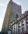
Bolivan Central Bank in La Paz
- Lapaz noche.JPG
Night time View in La Paz
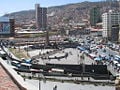
Center of La Paz
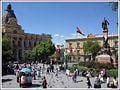
Plaza Murillo, (Government and Legislative Palaces on background) in La Paz
- SAN JORGE Bolivia.jpg
San Jorge, La Paz
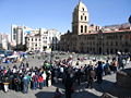
Plaza San Francisco
- La Paz-center.jpg
Center of La Paz
- ZONA SUR LA PAZ.jpg
Av. Ballivian, Zona Sur


.png)
See also
- Cochabamba
- Sucre
- Santa Cruz de la Sierra
- El Alto
- Calacoto
- San Pedro prison
antlebdnd
Notes
- ↑ Mark Whitaker, "The world's most dangerous road", BBC, November 2006. Retrieved December 11, 2007.
External links
All links Retrieved December 11, 2007.
- Museums in La Paz
- Excursions in the surrounding of La Paz
- High Altitude Pathology Institute IPPA La Paz
- Bolivian Yellow Pages
- 17 pictures of La Paz
- The world's most dangerous road
- Biking on the ROAD OF DEATH
-
- Mapping from Multimap or GlobalGuide or Google Maps
- Satellite image from WikiMapia
- Mapping from OpenStreetMap
Asunción, Paraguay · Bogotá, Colombia · Brasília, Brasil · Buenos Aires, Argentina · Caracas, Venezuela · Cayenne, French Guiana · Georgetown, Guyana · Grytviken, South Georgia and the South Sandwich Islands · La Paz, Bolivia · Lima, Peru · Montevideo, Uruguay · Paramaribo, Suriname · Quito, Ecuador · Santiago, Chile · Sucre, Bolivia · Stanley, Falkland Islands
Credits
New World Encyclopedia writers and editors rewrote and completed the Wikipedia article in accordance with New World Encyclopedia standards. This article abides by terms of the Creative Commons CC-by-sa 3.0 License (CC-by-sa), which may be used and disseminated with proper attribution. Credit is due under the terms of this license that can reference both the New World Encyclopedia contributors and the selfless volunteer contributors of the Wikimedia Foundation. To cite this article click here for a list of acceptable citing formats.The history of earlier contributions by wikipedians is accessible to researchers here:
The history of this article since it was imported to New World Encyclopedia:
Note: Some restrictions may apply to use of individual images which are separately licensed.