Difference between revisions of "Tel Megiddo" - New World Encyclopedia
m (→History) |
m |
||
| Line 11: | Line 11: | ||
| Link = http://whc.unesco.org/en/list/1108 | | Link = http://whc.unesco.org/en/list/1108 | ||
}} | }} | ||
| − | + | ||
'''Megiddo''' ({{lang-he|מגידו}}) is a hill in modern [[Israel]] near the [[Kibbutz]] of [[Megiddo (kibbutz)|Megiddo]], known for historical, geographical, and theological reasons. | '''Megiddo''' ({{lang-he|מגידו}}) is a hill in modern [[Israel]] near the [[Kibbutz]] of [[Megiddo (kibbutz)|Megiddo]], known for historical, geographical, and theological reasons. | ||
| Line 18: | Line 18: | ||
==History== | ==History== | ||
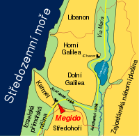
| + | [[Image:Megido mapa.svg|thumb|200px|Map shows Megiddo's location at the base of the [[Mount Carmel|Carmel]] mountain range along the Via Maris.]] | ||
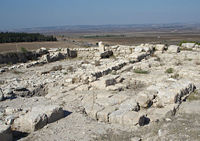
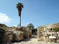
| + | [[Image:JPF-TelMegiddo.JPG|thumb|200px|Ruins atop Tel Megiddo.]] | ||
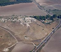
[[Image:Megiddo05.JPG|thumb|Tel Megiddo|200px|right]] | [[Image:Megiddo05.JPG|thumb|Tel Megiddo|200px|right]] | ||
Megiddo was a site of great importance in the ancient world, as it guarded the western branch of a narrow pass and an ancient [[trade route]] which connected the lands of [[Egypt]] and [[Assyria]]. In the Bible, this route was called [[Derekh HaYam]] ({{lang-he|דרך הים}}), or "Way of the Sea." It became an important military artery of later armies, and during the period of the [[Roman Empire]], the route was known as the [[Via Maris]]. Because of its strategic location at the crossroads of several major routes, Megiddo and its environs have witnessed several major battles throughout history. The site was inhabited from 7000 B.C.E. to 500 B.C.E. | Megiddo was a site of great importance in the ancient world, as it guarded the western branch of a narrow pass and an ancient [[trade route]] which connected the lands of [[Egypt]] and [[Assyria]]. In the Bible, this route was called [[Derekh HaYam]] ({{lang-he|דרך הים}}), or "Way of the Sea." It became an important military artery of later armies, and during the period of the [[Roman Empire]], the route was known as the [[Via Maris]]. Because of its strategic location at the crossroads of several major routes, Megiddo and its environs have witnessed several major battles throughout history. The site was inhabited from 7000 B.C.E. to 500 B.C.E. | ||
Revision as of 19:22, 29 October 2008
| Biblical Tells – Megiddo, Hazor, Beer Sheba* | |
|---|---|
| UNESCO World Heritage Site | |

| |
| State Party | |
| Type | Cultural |
| Criteria | ii, iii, iv, vi |
| Reference | 1108 |
| Region** | Europe and North America |
| Inscription history | |
| Inscription | 2005 (29th Session) |
| * Name as inscribed on World Heritage List. ** Region as classified by UNESCO. | |
Megiddo (Hebrew: מגידו) is a hill in modern Israel near the Kibbutz of Megiddo, known for historical, geographical, and theological reasons.
In ancient times Megiddo was an important city state. It is also known alternatively as Tel Megiddo (Hebrew) and Tell al-Mutesellim (Arabic). Megiddo is a tel (hill or mound) made of 26 layers of the ruins of ancient cities in a strategic location at the head of a pass through the Carmel Ridge, which overlooks the Valley of Jezreel from the west. The city is mentioned in the New Testament as the site for Armageddon.
History

Megiddo was a site of great importance in the ancient world, as it guarded the western branch of a narrow pass and an ancient trade route which connected the lands of Egypt and Assyria. In the Bible, this route was called Derekh HaYam (Hebrew: דרך הים), or "Way of the Sea." It became an important military artery of later armies, and during the period of the Roman Empire, the route was known as the Via Maris. Because of its strategic location at the crossroads of several major routes, Megiddo and its environs have witnessed several major battles throughout history. The site was inhabited from 7000 B.C.E. to 500 B.C.E.
Famous battles at Megiddo include:
- Battle of Megiddo of 1478 B.C.E.: fought between the armies of the Egyptian pharaoh Thutmose III and a large Canaanite coalition led by the rulers of Megiddo and Kadesh. This is the first documented battle in recorded history. The battle is described in detail in the hieroglyphics found on the walls of his temple in Upper Egypt.
- [[Battle of Megiddo of 609 B.C.E.: fought between Egypt and the Kingdom of Judah, in which King Josiah, fell. Josiah, hailed by the biblical writers as the greatest king since David, had ridden north from Jerusalem to head off an Egyptian force preparing to attack the Babylonian army.
- [[Battle of Megiddo of 1918 C.E.: fought during World War I between Allied troops, led by General Edmund Allenby, and the defending Ottoman army.
Megiddo is perhaps best known, however, as the site of a battle prophesied in the New Testament Book of Revelation. Known as Armageddon, this future encounter will supposedly pit the forces of good against the armies of evil. It is described as follows:
16Then they gathered the kings together to the place that in Hebrew is called Armageddon.
Then I saw three evil[a] spirits that looked like frogs; they came out of the mouth of the dragon, out of the mouth of the beast and out of the mouth of the false prophet. 14They are spirits of demons performing miraculous signs, and they go out to the kings of the whole world, to gather them for the battle on the great day of God Almighty.
15"Behold, I come like a thief! Blessed is he who stays awake and keeps his clothes with him, so that he may not go naked and be shamefully exposed."
16Then they gathered the kings together to the place that in Hebrew is called Armageddon.
Megiddo has been excavated three times. The first excavations were carried out between 1903 and 1905 by Gottlieb Schumacher for the German Society for Oriental Research. In 1925, digging was resumed by Oriental Institute of the University of Chicago, financed by John D. Rockefeller, Jr. until the outbreak of the Second World War. During these excavation it was discovered that there were twenty levels of habitation, and many of the uncovered remains are preserved at the Rockefeller Museum in Jerusalem and the Oriental Institute of the University of Chicago.
In the 1960's, Yigael Yadin conducted several smaller scaled excavations. Megiddo has most recently (since 1994) been the subject of biannual excavation campaigns conducted by The Megiddo Expedition of Tel Aviv University, directed by Israel Finkelstein and David Ussishkin, together with a consortium of international universities.
Modern Kibbutz of Megiddo is nearby just a little less then 1 km away to the south.
Today, Megiddo is an important junction on the main road connecting the center of Israel with lower Galilee and the northern region.
The Megiddo 'stables'
At Megiddo two stable complexes were excavated from Stratum IVA, one in the north and one in the south. The southern complex contained five structures built around a lime paved courtyard. The buildings themselves were divided into three sections. Two long stone paved aisles were built adjacent to a main corridor paved with lime. The buildings were about 21 meters long by 11 meters wide. Separating the main corridor from outside aisles was a series of stone pillars. Holes were bored into many of these pillars so that horses could be tied to them. Also, the remains of stone mangers were found in the buildings. These mangers were placed between the pillars to feed the horses. It is suggested that each side could hold 15 horses, giving each building an overall capacity of thirty horses. The buildings on the northern side of the city were similar in their construction. However, there was no central courtyard. The capacity of the northern buildings was about three hundred horses altogether. Both complexes could hold from 450-480 horses combined.
The buildings were found during excavations between 1927 and 1934 at Megiddo. Head excavator, P.L.O. Guy, originally interpreted the buildings as stables. Since then his conclusions have been challenged by scholars such as James Pritchard, Ze'ev Herzog, and Yohanan Aharoni. They suggest that the buildings should be interpreted as either storehouses, marketplaces or barracks. Nevertheless, Yigael Yadin and J. S. Holladay strongly argue against this conclusion. Other Tripartite Buildings have been found at other sites such as Hazor and Beer-Sheba.[1]
Ancient church discovered under prison
In 2005, Israeli archaeologist Yotam Tepper of Tel-Aviv University discovered the remains of a church, believed to be from the third or forth century, a time when Christians were still persecuted by the Roman Empire.
Among the finds is an approx. 54 square meter large mosaic with a Greek inscription stating that the church is consecrated to "the God Jesus Christ." The mosaic is very well preserved and features geometrical figures and images of fish, an early Christian symbol. It is speculated that this may be the oldest remains of a church in the Holy Land.[2] The remains were found within the grounds of a Israeli military prison, and Israeli authorities are currently speculating about moving the prison.
An inscription in the Megiddo church speaks of a Roman officer, "Gaianus," who donated "his own money" to have a mosaic made. Some authorities question an early dating for this site on the grounds that a Roman officer would not risk his career or even his life to build a church[3]. On the other hand, persecution of Christians was sporadic in the Roman Empire during the early third century.
Megiddo In Christian Prophecy
According to the Bible, this place will be the venue for Armageddon (that derives from the name's place in Hebrew) or the battle between the Antichrist coming up from Africa (returning from an imperialistic war) and Jesus.
See also
- Megiddo (disambiguation)
- Battle of Megiddo (disambiguation)
Notes
- ↑ Amihai Mazar, Archaeology of the Land of the Bible (New York: Doubleday, 1992), 476-78.
- ↑ Greek inscription in 'oldest church'
- ↑ Israeli Prisoners Dig Their Way to Early Christianity
External links
- The Megiddo Expedition
- Megiddo At Bibleplaces.com
- Tel Megiddo National Park from the Israel Nature and National Parks Protection Authority
- Megiddo: Tell el-Mutesellim from Images of Archaeological Sites in Israel
- Mageddo. Catholic Encyclopedia. - contains list of Biblical references
Coordinates: Template:World Heritage Sites in Israel
| |||||
Credits
New World Encyclopedia writers and editors rewrote and completed the Wikipedia article in accordance with New World Encyclopedia standards. This article abides by terms of the Creative Commons CC-by-sa 3.0 License (CC-by-sa), which may be used and disseminated with proper attribution. Credit is due under the terms of this license that can reference both the New World Encyclopedia contributors and the selfless volunteer contributors of the Wikimedia Foundation. To cite this article click here for a list of acceptable citing formats.The history of earlier contributions by wikipedians is accessible to researchers here:
The history of this article since it was imported to New World Encyclopedia:
Note: Some restrictions may apply to use of individual images which are separately licensed.


