Sydney
| Sydney New South Wales | |||||||
| 250px Location of Sydney within Australia | |||||||
| Population: • Density: |
4,284,379 (2006 estimate) (1st) 345.7/km² | ||||||
| Established: | January 26, 1788 | ||||||
| Area: | 12,144.6 km² | ||||||
| Time zone:
• Summer (DST) |
AEST (UTC+10)
AEDT (UTC+11) | ||||||
| Location: | •697 km from Melbourne • 793 km from Brisbane • 3314 km from Perth | ||||||
| LGA: | various (38) | ||||||
| County: | Cumberland | ||||||
| State District: | various (49) | ||||||
| Federal Division: | various (22) | ||||||
| |||||||
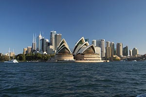
Sydney (pronounced /ˈsɪd.niː/) is the most populous city in Australia, with a metropolitan area population of approximately 4.28 million.[1] Sydney is the state capital of New South Wales, and is the site of the first European colony in Australia, established in 1788 at Sydney Cove by Arthur Phillip, leader of the First Fleet from Britain.[2] A resident of the city is referred to as a Sydneysider.
Sydney is located on Australia's south-east coast. The city is built around Port Jackson, which includes Sydney Harbour, leading to the city's nickname, "the Harbour City." It is Australia's largest financial centre and is home to the Australian Stock Exchange. Sydney's leading economic sectors include property and business services, retail, manufacturing, tourism, and health and community services.
Sydney is a major international tourist destination notable for its beaches and twin landmarks: the Sydney Opera House and the Harbour Bridge. The metropolitan area is surrounded by national parks, and contains many bays, rivers and inlets. It has been recognised as a global city by the Loughborough University group's 1999 inventory.[3] The city has played host to numerous international sporting events, including the 1938 British Empire Games, 2000 Summer Olympics and the 2003 Rugby World Cup. In 2008, Sydney will also host the 23rd Roman Catholic World Youth Day.
Sydney is one of the most multicultural cities in the world which reflects its role as a major destination for immigrants to Australia.[4] According to the Mercer cost of living survey, Sydney is Australia’s most expensive city, and the 21st most expensive in the world.[5]
History
It has been speculated that the Sydney region has been populated by indigenous Australians for at least 40,000 years.[2] At the time of the arrival of the First Fleet in 1788, 4000 - 8000 Aboriginal people lived in the region.[6] There were three language groups in the Sydney region; these were further refined into dialects spoken by smaller clans. The principal languages were Darug (the Cadigal, original inhabitants of the City of Sydney, spoke a coastal dialect of Darug), Dharawal and Guringai. Each clan had a territory; the location of that territory determined the resources available. Although urbanization has destroyed most evidence of these settlements (such as shell middens), Sydney and its environs are well known for numerous rock drawings and carvings due to the nature of the rock, Hawkesbury Sandstone.[citation needed]
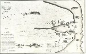
European interest in colonising Australia arose with the landing of British sea captain, Lieutenant James Cook in Botany Bay in 1770. Under instruction from the British government, a convict settlement was founded by Arthur Phillip in 1788. Phillip founded the colony at Sydney Cove on Port Jackson. He named it after the British Home Secretary, Thomas Townshend, Lord Sydney, in recognition of Sydney's role in issuing the charter authorising Phillip to establish a colony. [citation needed] In April 1789 a disease, thought to be smallpox, decimated the indigenous population of Sydney; a conservative estimate says that 500 to 1000 Aboriginal people died in the area between Broken and Botany Bays.[7] There was violent resistance to British settlement, notably by the warrior Pemulwuy in the area around Botany Bay, and conflicts were common in the area surrounding the Hawkesbury River. By 1820 there were only a few hundred Aborigines and Governor Macquarie had begun initiatives to 'civilize, Christianize and educate' the Aborigines by removing them from their clans.[8]
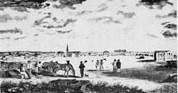
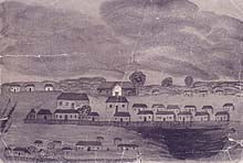
Macquarie's tenure as Governor of New South Wales was a period when Sydney was improved from its basic beginnings. Roads, bridges, wharves and public buildings were constructed by British and Irish convicts, and by 1822 the town had banks, markets, well-established thoroughfares and an organised constabulary. The 1830s and 1840s were periods of urban development, including the development of the first suburbs, as the town grew rapidly when ships began arriving from Britain and Ireland with immigrants looking to start a new life in a new country. On 20 July 1842 the municipal council of Sydney was incorporated and the town was declared the first city in Australia, Charles H. Chambers was the first mayor.[9] The first of several gold rushes started in 1851, and the port of Sydney has since seen many waves of people arriving from around the world. Rapid suburban development began in the last quarter of the 19th century with the advent of steam powered tramways and railways. With industrialisation Sydney expanded rapidly, and by the early 20th century it had a population well in excess of one million. The Great Depression hit Sydney badly. One of the highlights of the Depression era, however, was the completion of the Sydney Harbour Bridge in 1932.[10]
Throughout the 20th century Sydney continued to expand with various new waves of European and (later) Asian immigration, resulting in its highly cosmopolitan atmosphere.
Geography
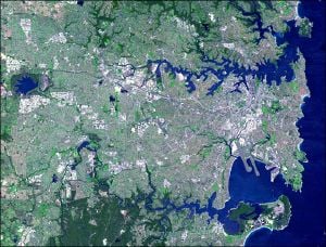
Sydney is in a coastal basin bordered by the Pacific Ocean to the east, the Blue Mountains to the west, the Hawkesbury River to the north and the Woronora Plateau to the south. Sydney lies on a submergent coastline, where the ocean level has risen to flood deep river valleys (rias) carved in the hawkesbury sandstone. One of these drowned valleys, Port Jackson, better known as Sydney Harbour, is the largest natural harbour in the world.[11] There are more than 70 harbour and ocean beaches, including the famous Bondi Beach, in the urban area. Sydney's urban area covers 1687 square kilometres (651 mi²) as at 2001.[12] The Sydney Statistical Division, used for census data, is the unofficial metropolitan area[13] and covers 12,145 square kilometres (4,689 mi²).[14] This area includes the Central Coast and Blue Mountains as well as broad swathes of national park and other unurbanised land.
Geographically, Sydney sprawls over two major regions: the Cumberland Plain, a relatively flat region lying to the south and west of the harbour, and the Hornsby Plateau, a sandstone plateau lying mainly to the north of the harbour, dissected by steep valleys. The oldest parts of the city are located in the flat areas south of the harbour; the North Shore was slower to develop because of its hilly topography, and was mostly a quiet backwater until the Sydney Harbour Bridge was opened in 1932, linking it to the rest of the city.
Climate
Sydney has an oceanic climate with warm summers and mild winters, with rainfall spread throughout the year. The weather is moderated by proximity to the ocean, and more extreme temperatures are recorded in the inland western suburbs. The warmest month is January, with an average air temperature range at Observatory Hill of 18.6 °C–25.8 °C and an average of 14.6 days a year over 30 °C. The maximum recorded temperature was 45.3 °C on 14 January 1939 at the end of a 4 day nationwide heat wave.[15] The winter is mildly cool, with temperatures rarely dropping below 5 °C in coastal areas. The coldest month is July, with an average range of 8.0 °C–16.2 °C. The lowest recorded minimum was 2.1 °C. Rainfall is fairly evenly divided between summer and winter, but is slightly higher during the first half of the year, when easterly winds dominate. The average annual rainfall, with moderate to low variability, is 1217.0 millimetres (47.9 in), falling on an average 138.0 days a year.[16][17] Snowfall last occurred in the Sydney City area in the 1830s.[18]
Although the city does not suffer from cyclones or significant earthquakes, the El Niño Southern Oscillation plays an important role in determining Sydney's weather patterns: drought and bushfire on the one hand, and storms and flooding on the other, associated with the opposite phases of the oscillation. Many areas of the city bordering bushland have experienced bushfires, notably in 1994 and 2001/2002 — these tend to occur during the spring and summer. The city is also prone to severe hail storms and wind storms. One such storm occurred in Sydney's eastern and city suburbs on the evening of 14 April 1999, producing massive hailstones of at least 9 centimetres (3.5 in) in diameter and resulting in insurance losses of around $1.5 billion in less than one hour.[19] The city is also prone to flash flooding from enormous amounts of rain caused by East Coast Lows (a low pressure depression which deepens off the state usually in winter and early spring which can bring significant damage due to heavy rain, cyclonic winds and huge swells). The most notable event was the great Sydney flood which occurred on 6 August 1986 and dumped a record 327.6 millimetres (12.9 in) on the city in 24 hours. This caused major traffic chaos and damage in many parts of the metropolitan area.[20]
The Bureau of Meteorology have reported that the last four years in Sydney have been the warmest on record (since 1859). 2004 had an average daily maximum temperature of 23.39 °C, 2005 - 23.35 °C, 2002 - 22.91 °C and 2003 - 22.65 °C. The average daily maximum between 1859 and 2004 was 21.6 °C. For the first nine months of 2006 the mean temperature was 18.41 °C; the warmest year previously was 2004 with 18.51 °C. Since the beginning of 2002, there have been only two months in which the average daily maximum was below average: March 2005 (0.43 °C below average) and June 2006 (0.25 °C below average).[citation needed]
| Jan | Feb | Mar | Apr | May | Jun | Jul | Aug | Sep | Oct | Nov | Dec | Year | ||
|---|---|---|---|---|---|---|---|---|---|---|---|---|---|---|
| Mean daily maximum temperature (°C) | 25.8 | 25.7 | 24.7 | 22.4 | 19.3 | 16.9 | 16.2 | 17.7 | 19.9 | 22.0 | 23.6 | 25.1 | 21.6 | |
| Mean daily minimum temperature (°C) | 18.6 | 18.7 | 17.5 | 14.7 | 11.5 | 9.2 | 8.0 | 8.9 | 11.0 | 13.5 | 15.5 | 17.5 | 13.7 | |
| Mean total rainfall (mm) | 103.3 | 117.4 | 131.2 | 127.2 | 123.3 | 128.1 | 98.1 | 81.5 | 68.7 | 76.9 | 83.1 | 78.1 | 1217.0 | |
| Mean number of rain days | 12.1 | 12.3 | 13.3 | 12.0 | 12.0 | 11.4 | 10.3 | 9.9 | 10.3 | 11.5 | 11.4 | 11.5 | 138.0 | |
| Source: Bureau of Meteorology | ||||||||||||||
Urban structure
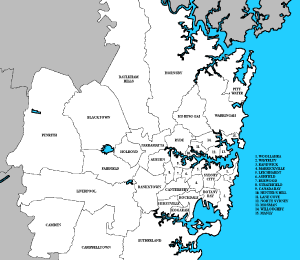
Template:Sydney Urban Areas Labelled Map
The extensive area covered by urban Sydney is formally divided into more than 300 suburbs (for addressing and postal purposes), and administered as 38 local government areas. There is no city-wide government, but the Government of New South Wales and its agencies have extensive responsibilities in providing metropolitan services.[21] The City of Sydney itself covers a fairly small area comprising the central business district and its neighbouring inner-city suburbs. In addition, regional descriptions are used informally to conveniently describe larger sections of the urban area. These include Eastern Suburbs, Hills District, Inner West, Lower North Shore, Northern Beaches, North Shore, St George, Southern Sydney, South-eastern Sydney, South-western Sydney, Sutherland Shire and Western Sydney. However, many suburbs are not conveniently covered by any of these categories.
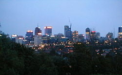
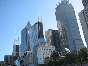
Sydney's central business district (CBD) extends southwards for about 2 kilometres (1.25 mi) from Sydney Cove, the point of the first European settlement. Densely concentrated skyscrapers and other buildings including historic sandstone buildings such as the Sydney Town Hall and Queen Victoria Building are interspersed by several parks such as Wynyard and Hyde Park. The Sydney CBD is bounded on the east side by a chain of parkland that extends from Hyde Park through the Domain and Royal Botanic Gardens to Farm Cove on the harbour. The west side is bounded by Darling Harbour, a popular tourist and nightlife precinct while Central station marks the southern end of the CBD. George Street serves as the Sydney CBD's main north-south thoroughfare.
Although the CBD dominated the city's business and cultural life in the early days, other business/cultural districts have developed in a radial pattern since World War II. As a result, the proportion of white-collar jobs located in the CBD declined from more than 60 per cent at the end of World War II to less than 30 per cent in 2004.[citation needed] Together with the commercial district of North Sydney, joined to the CBD by the Harbour Bridge, the most significant outer business districts are Parramatta in the central-west, Blacktown in the west, Bondi Junction in the east, Liverpool in the southwest, Chatswood to the north, and Hurstville to the south.
Density
Sydney is particularly noted for its low population density. The reasons for Sydney's low-density development are rooted in its history. [citation needed] Surrounded by land that was considered unowned by the city's founders, early Sydney enjoyed relatively low land values, allowing more residents to acquire larger plots on which to live. [citation needed] This was reinforced by Sydney's development as a predominantly middle class, commercial city, in which even the working classes enjoyed higher wages and living standards than their counterparts in Europe. [citation needed]
Finally, Sydney acquired its public transport system early on in its life. Working-class suburbs could thus be built far from the city centre, whereas in older cities, the need to maintain walking distance between residential and employment centres kept sprawl to a minimum.[22]
Coupled with successive governments' willingness to release new land on the city's outskirts for further development, this history has given Sydney a low-density self-image. [citation needed] Ingrained hostility to urban consolidation and higher density living represents a major challenge to the city's future growth. [citation needed]
Governance
Apart from the limited role of the Cumberland County Council from 1945–1964, there has never been an overall governing body for the Sydney metropolitan area; instead, the metropolitan area is divided into local government areas (LGAs). These areas have elected councils which are responsible for functions delegated to them by the New South Wales State Government, such as planning and garbage collection.
The City of Sydney includes the central business area and some adjoining inner suburbs, and has in recent years been expanded through amalgamation with adjoining local government areas, such as South Sydney. It is led by the elected Lord Mayor of Sydney and a council. The Lord Mayor, however, is sometimes treated as a representative of the whole city, for example during the Olympics.
The 38 LGAs in Sydney are:
|
|
|
|
|
|
Most citywide government activities are controlled by the state government. These include public transport, main roads, traffic control, policing, education above preschool level, and planning of major infrastructure projects. Because a large proportion of New South Wales' population lives in Sydney, state governments have traditionally been reluctant to allow the development of citywide governmental bodies, which would tend to rival the state government. For this reason, Sydney has always been a focus for the politics of both State and Federal Parliaments. For example, the boundaries of the City of Sydney LGA have been significantly altered by state governments on at least four occasions since 1945, with expected advantageous effect to the governing party in the New South Wales Parliament at the time.[23]
Economy
The largest economic sectors in Sydney, measured by numbers of people employed, include property and business services, retail, manufacturing, and health and community services.[24] Since the 1980s, jobs have moved from manufacturing to the services and information sectors. Sydney provides approximately 25% of the country's total GDP.[25]
Sydney is the largest corporate and financial centre in Australia and is also an important financial centre in the Asia Pacific.[26] The Australian Stock Exchange and the Reserve Bank of Australia are located in Sydney, as are the headquarters of 90 banks and more than half of Australia's top companies, and the regional headquarters for around 500 multinational corporations.[27] Fox Studios Australia has large movie studios in the city.
The Sydney Futures Exchange (SFE) is one of the Asia Pacific's largest financial futures and options exchanges, with 64.3 million contracts traded during 2005. In global terms it is the 12th largest futures market in the world and the 19th largest including options.[28] With the increasing commercial role of Sydney's many medical laboratories and research centres, science and research is another strong growth sector.[citation needed]
Tourism plays an important role in Sydney's economy, with 7.8 million domestic visitors and 2.5 million international visitors in 2004.[29]
As of September 2003, the unemployment rate in Sydney was 5.3%.[30] According to The Economist Intelligence Unit's Worldwide cost of living survey, Sydney is the sixteenth most expensive city in the world, while a UBS survey ranks Sydney as 18th in the world in terms of net earnings.[31]
As of December 2005, Sydney has the highest median house price of any Australian capital city at $485 000.[32] A report published by the OECD in November 2005, shows that Australia has the Western World's highest housing prices when measured against rental yields.[33]
Sydney has been classified as a "Beta" global city by the Globalization and World Cities Study Group and Network.[34]
Demographics
3,455,110 people lived in Sydney's urban area as at 2001.[12] As of 2006, there are an estimated 4,119,190 people living in the Sydney Statistical Division[35] Inner Sydney being the most densely populated place in Australia with 4023 persons per square kilometre.[36] The statistical division is larger in area than the urban area, as it allows for predicted growth. A resident of Sydney is commonly referred to as a Sydneysider.[37]
In the 2006 census, the most common self-described ancestries identified for Sydney residents were Australian, English, Irish, and Chinese. The Census also recorded that 1% of Sydney's population identified as being of indigenous origin and 31.7% were born overseas. The three major sources of immigrants are England, China and New Zealand [35]. Significant numbers of immigrants also came from Vietnam, Lebanon, Italy, India and the Philippines. Most Sydneysiders are native speakers of English; many have a second language, the most common being Arabic (including the Lebanese dialect) Chinese languages (Mandarin and Cantonese), and Greek.[35] Sydney has the seventh largest percentage of a foreign born population in the world, ahead of cities such as the highly multicultural London and Paris.[38]
Some ethnic groups are associated with the suburbs where they first settled: the Italians with Leichhardt, Haberfield, Five Dock, Greeks with Earlwood, Marrickville and Brighton Le Sans, Portuguese with Petersham, Lebanese with Lakemba and Bankstown, Koreans with Campsie and Strathfield, ethnic Macedonians with Rockdale, Irish and New Zealanders with Bondi, Jews with Bondi, Waverley, St Ives and Rose Bay, Indians with Westmead and Parramatta, Chinese with Hurstville, Chatswood, Ashfield and Haymarket (where Sydney's Chinatown has emerged), Armenians with Ryde and Willoughby, Serbs with Liverpool, Turks with Auburn, Filipinos with Blacktown and Mount Druitt, Vietnamese with Cabramatta and Hispanics with Fairfield.
The median age of a Sydney resident is 34, with 12% of the population over 65 years.[30] 15.2% of Sydney residents have educational attainment equal to at least a bachelor's degree,[39] which is lower than the national average of 19%.[citation needed]
According to the 2006 census, 29.1% of Sydney residents identified as Catholics, 17.9% as Anglicans, 17.0% as members of other Christian denominations, 3.7% as Buddhists, 3.9% as Muslims, 1.7% as Hindus, 0.9% as Jews and 14.1% as having no religion.[40]
Education
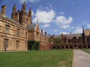
Sydney is home to some of Australia's most prominent universities, and is the site of Australia's first university, the University of Sydney, established in 1850.[41] There are five other public universities operating primarily in Sydney: the University of New South Wales, Macquarie University, the University of Technology, Sydney, the University of Western Sydney, and the Australian Catholic University (two out of six campuses). Other universities which operate secondary campuses in Sydney include the University of Notre Dame Australia and the University of Wollongong.
There are four multicampus government funded Technical and Further Education (TAFE) institutes in Sydney which provide vocational training at a tertiary level: the Sydney Institute of Technology, Northern Sydney Institute of TAFE, Western Sydney Institute of TAFE and South Western Sydney Institute of TAFE.
Sydney has public, denominational, and independent schools. Public schools, including pre-schools, primary and secondary schools, and special schools are administered by the New South Wales Department of Education and Training. There are four state administered education areas in Sydney, that together coordinate 919 schools.[citation needed] Out of the thirty selective high schools in the state, twenty-five of those are located in Sydney.[citation needed]
Culture
Arts and entertainment
Sydney has a wide variety of cultural sites and institutions. Sydney's iconic Opera House has five theatres capable of hosting a range of performance styles; it is the home of Opera Australia—the third busiest opera company in the world, and the Sydney Symphony Orchestra.[42] Other venues include the Sydney Town Hall, City Recital Hall, the State Theatre and the Wharf Theatre.
The Sydney Dance Company under the leadership of Graeme Murphy during the late 20th century has also gained acclaim. The Sydney Theatre Company has a regular roster of local plays, such as noted playwright David Williamson, classics and international playwrights.
In 2007, New Theatre (Newtown) celebrates 75 years of continuous production in Sydney. Other important theatre companies in Sydney include Company B and Griffin Theatre Company. From the 1940s through to the 1970s the Sydney Push, a group of authors and political activists whose members included Germaine Greer, influenced the city's cultural life.
The National Institute of Dramatic Art, based in Kensington, boasts internationally famous alumni such as Mel Gibson, Baz Luhrmann and Cate Blanchett. Sydney's role in the film industry has increased since the opening of Fox Studios Australia in 1998. Prominent films which have been filmed in the city include Moulin Rouge!, Mission Impossible II, Star Wars episodes II and III, Superman Returns, Dark City, Dil Chahta Hai, and The Matrix. Films using Sydney as a setting include Finding Nemo, Strictly Ballroom, Mission Impossible II, Muriel's Wedding, and Dirty Deeds. As of 2006, over 229 films have been set, or featured Sydney.[43]
Sydney hosts many different festivals and some of Australia's largest social and cultural events. These include the Sydney Festival, Australia's largest festival which is a celebration involving both indoor and free outdoor performances throughout January; the Big Day Out, a travelling rock music festival which originated in Sydney; the Gay and Lesbian Mardi Gras along Oxford Street; the Sydney Film Festival and many other smaller festivals such as Tropfest and Archibald Prize, a competition organised by the Art Gallery of New South Wales. The Sydney Royal Easter Show which is the largest event in Australia is held every year at Sydney Olympic Park, the final of Australian Idol takes place on the steps of the Opera House, and Australian Fashion Week takes place in April/May. Also Sydney's New Years Eve and Australia Day celebrations are the largest in Australia.
Australian rock bands which formed in Sydney include AC/DC, Rose Tattoo, The Vines, Sick Puppies , Midnight Oil, INXS, Noiseworks, Hoodoo Gurus, The Church, Radio Birdman, You Am I, The Cruel Sea, The Whitlams, Alex Lloyd, Wolfmother, indie rockers The Clouds and The Crystal Set, electronic music pioneers Severed Heads, Single Gun Theory and Itch-E and Scratch-E. Jazz groups such as the Sydney-based The Necks have performed at The Basement and the Harbourside Brasserie. On 7th July 2007, Sydney was one of the legs of the global concert series called Live Earth which was hosted jointly with other global cities around the world.
Sydney's most popular nightspots include Kings Cross, Oxford Street, Darling Harbour, Circular Quay and The Rocks which all contain various bars, nightclubs and restaurants. Star City Casino, is Sydney's only casino and is situated around Darling Harbour. There are also many traditional pubs, cafes and restaurants in inner city areas such as Newtown, Balmain and Leichhardt. Sydney's main live music hubs include areas such as Newtown and Annandale. It once had thriving live music scene in the 1970s and 1980s, nurturing great acts such as AC/DC, Midnight Oil and INXS.
Sydney also has many shopping centres and retail outlets throughout the city. These include Westfield Parramatta, a large shopping complex located in Western Sydney, and Westfield Bondi Junction a shopping centre in the Eastern Suburbs which caters for the upmarket consumer. The Queen Victoria Building on George Street also contains many shops, as do other parts of the city around Pitt Street and Oxford Street which sell more niche products. Many of the large regional centres around the metropolitan area also contain large shopping complexes.
Sydney has several museums. The biggest are the Australian Museum (natural history and anthropology), the Powerhouse Museum (science, technology and design), the Art Gallery of New South Wales, the Museum of Contemporary Art and the Australian National Maritime Museum.
Being Australia's oldest city there is also much architecture and historic buildings to be seen throughout the city. Some of the most well know architectural sites in Sydney include Sydney Opera House, Queen Victoria Building, Martin Place and Sydney Town Hall. Some of the most well known historic buildings are the Sydney Mint, one of Australia's oldest buildings, Fort Denison, a penal site which was built in the colonial days on a small island situated on the harbour, as well as the heritage listed buildings built on The Rocks which were the first buildings built in Australia on settlement.
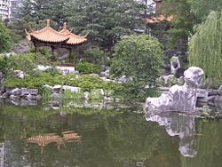
Sydney is well endowed with open spaces, and has many natural areas even within the city centre. Within the Sydney central business district are the Chinese Garden of Friendship, Hyde Park, The Domain and the Royal Botanical Gardens. The metropolitan area contains several national parks, including the Royal National Park, the second oldest national park in the world and several parks in Sydney's far west which are part of the World Heritage listed Greater Blue Mountains Area.[44]
Sport is also an important part of the culture in Sydney. For more information go to Sport in Sydney or Sport in New South Wales.
Media
Newspapers
Sydney has two main daily newspapers. The Sydney Morning Herald (which is the oldest Australian newspaper) is a broadsheet, and is Sydney's newspaper of record with extensive coverage of domestic and international news, culture and business. It is also the oldest extant newspaper in Australia, having been published regularly since 1831. The Herald's competitor, The Daily Telegraph, is a News Corporation-owned tabloid. Both papers have tabloid counterparts published on Sunday, The Sun-Herald and the Sunday Telegraph, respectively.
Television
The three commercial television networks (Seven, Nine and Ten), as well as the government national broadcast services (ABC and SBS) each have a presence in Sydney. Historically, the networks have been based on the north shore, but the last decade has seen several move to the inner city. Nine have kept their headquarters north of the harbour, in Willoughby. Ten have their studios in a redeveloped section of the inner-city suburb of Pyrmont, and Seven also have headquarters in Pyrmont as well as a new purpose built news studio in the CBD. The ABC has a large headquarters and production facility in the neighbouring suburb of Ultimo and SBS have their studios at Artarmon. Foxtel and Optus both supply pay-TV over their cable services to most parts of the urban area. The five free-to-air networks have provided Digital Free-to-air TV transmissions in Sydney since January 2001. Additional services recently introduced include ABC's Second Channel ABC2 (Channel 21), SBS's world news service SBS2, an on-air program guide (Channel 4), ABC news, sport, and weather items (Channel 41), ChannelNSW: Government and Public Information (Channel 45), Australian Christian Channel (Channel 46), MacquarieBank TV (Channel 47), SportsTAB (Channel 48), Expo Home Shopping (Channel 49), and Federal parliamentary broadcasts.
Film
Sydney is Australia’s centre for film and media. Many of the landmarks in Sydney have been referenced, shown and the setting for countless films and television programs. Sydney also has a wide amount of references to films that have been set in the city, the most famous being Finding Nemo, which was set in the famous Sydney Harbour.
Radio
Many AM and FM government, commercial and community radio services broadcast in the Sydney area. The local ABC radio station is 702 ABC Sydney (formerly 2BL). The talkback radio genre is dominated by the perennial rivals 2GB and 2UE. Popular music stations include Triple M, 2Day FM and Nova 96.9, which generally targets people under 40. In the older end of the music radio market, Vega & MIX 106.5 targets the 25 to 54 age group, while WS-FM targets the 40 to 54 age group with their Classic Hits format mostly focussing on the 70's & 80's. Triple J, 2SER and FBi Radio provide a more independent, local and alternative sound. There are also a number of community stations broadcasting to a particular language group or local area.
Infrastructure
Health
The Government of New South Wales operates the public hospitals in the Sydney metropolitan region. Management of these hospitals and other specialist health facilities are coordinated by 4 Area Health Services: Sydney South West (SSWAHS), Sydney West (SWAHS), Northern Sydney and Central Coast (NSCCAHS) and the South Eastern Sydney and Illawarra (SESIAHS) Area Health Services. There are also a number of private hospitals in the city, many of which are aligned with religious organisations.
Transport
Most Sydney residents travel by car through the system of roads, freeways and tollways (known as motorways). The most important trunk routes in the urban area form the nine Metroad systems, which includes the 110 kilometre Sydney Orbital Network. Sydney is also served by extensive train, taxi, bus and ferry networks.
Sydney trains are run by CityRail, a corporation of the New South Wales State Government. Trains run as suburban commuter rail services in the outer suburbs, then converge in an underground city loop service in the central business district. In the years following the 2000 Olympics, CityRail's performance declined significantly.[45] In 2005, CityRail introduced a revised timetable and employed more drivers.[46] A large infrastructure project, the Clearways project, is scheduled to be completed by 2010.[47][48][49]
Sydney has one privately operated light rail line, the Metro Light Rail, running from Central Station to Lilyfield along a former goods train line. There is also a small monorail which runs in a loop around the main shopping district and Darling Harbour. Sydney was once served by an extensive tram network, which was progressively closed in the 1950s and 1960s. Most parts of the metropolitan area are served by buses, many of which follow the pre-1961 tram routes. In the city and inner suburbs the state-owned Sydney Buses has a monopoly. In the outer suburbs, service is contracted to many private bus companies. Construction of a network of rapid bus transitways in areas not previously well served by public transport began in 1999, and the first of these, the Liverpool-Parramatta Rapid Bus Transitway opened in February 2003. Sydney Ferries, another State government-owned organisation, runs numerous commuter and tourist ferry services on Sydney Harbour and the Parramatta River.
Kingsford Smith International Airport, located in the suburb of Mascot, is Sydney's main airport, and the oldest continuously operating commercial airport in the world. The smaller Bankstown Airport mainly serves private and general aviation. There are light aviation airfields at Hoxton Park and Camden. RAAF Base Richmond lies to the north-west of the city. The question of whether Sydney needs a second international airport has raised much controversy. A 2003 study found that Kingsford Smith can manage as Sydney's sole international airport for 20 years with a significant increase in airport traffic predicted. [citation needed] The resulting expansion of the airport will have a substantial impact on the community, including additional aircraft noise affecting residents. Land has been acquired at Badgerys Creek for a second airport and alternative sites have been mooted. [citation needed]
Utilities
Water storage and supply for Sydney is managed by the Sydney Catchment Authority, which is an agency of the NSW Government that sells bulk water to Sydney Water and other agencies. Water in the Sydney catchment is chiefly stored in dams in the Upper Nepean Scheme, the Blue Mountains, Woronora Dam, Warragamba Dam and the Shoalhaven Scheme.[50] Historically low water levels in the catchment have led to water use restrictions and the NSW government is investigating alternative water supply options, including grey water recycling and the construction of a seawater reverse osmosis desalination plant at Kurnell.[51] Sydney Water also collects the wastewater and sewerage produced by the city.
Three companies supply natural gas and electricity to Sydney: Energy Australia, AGL and Integral Energy. Numerous telecommunications companies operate in Sydney providing terrestrial and mobile telecommunications services.

Notes
- ↑ 3218.0 - Regional Population Growth, Australia, 1996 to 2006. Australian Bureau of Statistics.
- ↑ 2.0 2.1 History of Australia. Oz Experience.
- ↑ Beaverstock, J.V.; Smith, R.G.; Taylor, P.J.. Research Bulletin 5: A Roster of World Cities. Globalization and World Cities.
- ↑ Designing for Diversity: the Multicultural City. 1995 Global Cultural Diversity Conference Proceedings, Sydney. Australian Government Department of Immigration and Citizenship.
- ↑ Cost of living - The world's most expensive cities. City Mayors.
- ↑ Kohen, J. L. 2000. First and last peoples: Aboriginal Sydney. In J. Connell (Ed.). Sydney the emergence of a global city. pp 76-95. Oxford University Press ISBN 0-19-550748-7, pp 76-78
- ↑ Ibid, pp 81-82
- ↑ Ibid, pp 83
- ↑ Australian Encyclopaedia Volume 2, p 524, Angus and Robertson Limited, 1926
- ↑ Harbour Bridge Views (2007). Brief History of the Sydney Harbour Bridge. Retrieved October 8, 2006.
- ↑ Showcase Destinations Sydney, Australia: The Harbour City by David Latta
- ↑ 12.0 12.1 2016.0 Census of Population and Housing: Selected Characteristics for Urban Centres, Australia, Australian Bureau of Statistics, 2003-03-26
- ↑ 1217.0.55.001 - Glossary of Statistical Geography Terminology, 2003, Australian Bureau of Statistics, 2003
- ↑ "2032.0 - Census of Population and Housing: Australia in Profile – A Regional Analysis, 2001", Australian Bureau of Statistics, 2004-01-16
- ↑ Bureau of Meteorology. 2006. Climate summary for Sydney, January 2006
- ↑ Australian Bureau of Meteorology. 2005. Climate averages.
- ↑ Ellyard, D. 1994. Droughts and Flooding Rains. Angus & Robertson ISBN 0-207-18557-3
- ↑ MacDonnell, Freda. Thomas Nelson (Australia) Limited, 1967. Before King’s Cross
- ↑ The Sydney Hailstorm - 14 April 1999 (html). Bureau of Meteorology. Retrieved 2006-10-05.
- ↑ Rain in Sydney, 1986 in Australian Climate Extremes, Bureau of Meteorology, accessed 9 September 2006.
- ↑ Department of Local Government. Local Council Boundaries Sydney Outer (SO)
- ↑ Forster, Clive 1996 Australian Cities: Continuity and Change. Oxford University Press
- ↑ Golder, Hilary, Sacked: Removing and Remaking the Sydney City Council, Sydney, 2004.
- ↑ Australian Bureau of Statistics. 2002. Sydney - Basic Community Profile and Snapshot - 2001 Census
- ↑ City Commerce - City of Sydney Media Centre. Accessed 21 July, 2006.
- ↑ Daly, M. T. and Pritchard, B. 2000. Sydney:Australia's financial and commercial capital. In J. Connell (Ed.). Sydney the emergence of a global city. pp 76-95. Oxford University Press ISBN 0-19-550748-7, pp 167-188
- ↑ City Commerce - City of Sydney Media Centre. Accessed 21 July, 2006.
- ↑ Overview, Sydney Futures Exchange website, accesssed 3 July 2006
- ↑ Tourism NSW. 2004.Tourism Data Card - Forecasts, Economic Impacts and selected Regional Data - 2004
- ↑ 30.0 30.1 Australian Bureau of Statistics. 2005. Sydney Statistical Division.
- ↑ [1] CityMayors.com, accessed 3 July 2007
- ↑ Real Estate Institute of Australia. December 14 2005. Still strong confidence in the housing market, Press Release
- ↑ Boilling, M. February 2 2006. City among most costly, Herald Sun
- ↑ Beaverstock, J.V. et alA Roster of World Cities
- ↑ 35.0 35.1 35.2 2006 Census data for Sydney
- ↑ Australian Bureau of Statistics. 2005. National Regional Profile: Inner Sydney
- ↑ about.com, Strine and Aussie Slang. Sanger to Sydneysider
- ↑ http://hdr.undp.org/reports/global/2004/pdf/hdr04_chapter_55.pdf
- ↑ The City of Sydney Community Profile - Sydney Statistical Division. 2006. What are our qualifications?, profile.id
- ↑ Religious Affiliation by Sex - Sydney, 2006 census
- ↑ The Australian Education Network University and College Guide. 2005. Rankings of Australian universities.
- ↑ http://www.dfat.gov.au/facts/culture_arts.html
- ↑ http://www.imdb.com/find?s=kw&q=Sydney
- ↑ NPWS website, Royal National Park
- ↑ CityRail. (2006). Yearly On-Time Running. Retrieved October 8, 2006: http://www.cityrail.info/aboutus/our_performance/otr_year_tot_chart.jsp
- ↑ CityRail (2005). Times are changing at CityRail
- ↑ CityRail (2002). Rail Clearways Plan
- ↑ Kerr, J. and A. Smith. July 22 2004. Panic stations over CityRail driver exodus. Sydney Morning Herald
- ↑ Kerr, J. December 4 2004. Terminal dilemma. Sydney Morning Herald
- ↑ Sydney Catchment Authority. History of Sydney's water supply
- ↑ Sydney Water. Sydney's desalination project
ReferencesISBN links support NWE through referral fees
- Morris, Jan. Sydney. New York: Random House, 1992. ISBN 978-0394550985
- Porter, Peter, & Brake, Brian. Sydney. Amsterdam: Time-Life Books, 1980. ISBN 978-0705405027
- Watson, Anne. Building a Masterpiece: The Sydney Opera House. Sydney: PowerHosue Publishing, 2006. ISBN 978-0853319412
External links
- WikiSatellite view of Sydney at WikiMapia
- Map of Sydney and surrounds from Bonzle Digital Atlas of Australia
- Australian Museum: Aboriginal people of coastal Sydney
Credits
New World Encyclopedia writers and editors rewrote and completed the Wikipedia article in accordance with New World Encyclopedia standards. This article abides by terms of the Creative Commons CC-by-sa 3.0 License (CC-by-sa), which may be used and disseminated with proper attribution. Credit is due under the terms of this license that can reference both the New World Encyclopedia contributors and the selfless volunteer contributors of the Wikimedia Foundation. To cite this article click here for a list of acceptable citing formats.The history of earlier contributions by wikipedians is accessible to researchers here:
The history of this article since it was imported to New World Encyclopedia:
Note: Some restrictions may apply to use of individual images which are separately licensed.
