Difference between revisions of "Phong Nha-Ke Bang" - New World Encyclopedia
Dan Davies (talk | contribs) (→Recognition by UNESCO: deleted) |
Dan Davies (talk | contribs) (→Tourist activities: deleted) |
||
| Line 84: | Line 84: | ||
| − | |||
[[Image:Phongnhatourism.jpg|220px|thumb|right|Boats for tourist in Phong Nha-Ke Bang National Park]] | [[Image:Phongnhatourism.jpg|220px|thumb|right|Boats for tourist in Phong Nha-Ke Bang National Park]] | ||
| − | |||
| − | |||
| − | |||
| − | |||
| − | |||
| − | |||
| − | |||
| − | |||
| − | |||
| − | |||
| − | |||
| − | |||
| − | |||
| − | |||
| − | |||
| − | |||
| − | |||
| − | |||
| − | |||
==Management issues== | ==Management issues== | ||
Revision as of 00:05, 4 August 2008
| Phong Nha-Ke Bang National Park* | |
|---|---|
| UNESCO World Heritage Site | |
 | |
| State Party | |
| Type | Natural |
| Criteria | viii |
| Reference | 951 |
| Region** | Asia-Pacific |
| Inscription history | |
| Inscription | 2003 (27th Session) |
| * Name as inscribed on World Heritage List. ** Region as classified by UNESCO. | |
Phong Nha - Ke Bang (Vietnamese: Vườn quốc gia Phong Nha-Kẻ Bàng) designates a national park and UNESCO World Heritage Site in the Bố Trạch and Minh Hóa districts of central Quang Binh Province, in north-central Vietnam, about 500 kilometers south of the nation's capital, Hanoi. The park borders the Hin Namno Nature Reserve in the province of Khammouan, Laos by the west, 42 kilometers east of South China Sea from its point. Phong Nha-Ke Bang National Park sits in a limestone zone of 200,000 hectare in Vietnamese territory and borders another limestone zone of 200,000 hectares of Hin Namno in Laotian territory. The core zone of the national park covers 85,754 hectares and a buffer zone of 195,400 ha.[1] The Vietnamese government created the park to protect one of the world's two largest karst regions with 300 caves and grottoes and also protects the ecosystem of limestone forest of the Annamite Range region in north central coast of Vietnam. [2]
Phong Nha-Ke Bang area has been noted for its cave and grotto systems, composed of 300 caves and grottos, with a total length of about 70 kilometers, of which only twenty have been surveyed by Vietnamese and British scientists; seventeen of them in located in the Phong Nha area and three in the Ke Bang area. Phong Nha holds several world cave records, as it has the longest underground river, as well as the largest caverns and passageways.[1]
Exploration

Champa inscriptions carved on steles and altars in the cave demonstrate that people had inhabited the cave long before Vietnam annexed the area in the nam tien southward expansion. In 1550, Dương Văn An became the first Vietnamese man to write about Phong Nha cave. Phong Nha cave has been depicted in 9 urns in the Citadel of the Nguyen Dynasty in Huế.[1] In 1824, king Minh Mang conferred the title "Diệu ứng chi thần" (Han Tu: 妙應之神) on Phong Nha cave. Nguyen kings bestowed the title "Thần Hiển Linh" (Han Tu: 神顯靈).
In the late 19th century, Léopold Michel Cadière, a French Catholic priest, conducted an expedition to explore Phong Nha cave, where he discovered Champa scripts. He proclaimed Phong Nha cave "the number one cave of Indochina"[3]. In July 1924, an English expeditionist, Barton, declared Phong Nha cave second to none of famous caves of Padirac (France), Cuevas del Drach (Spain) in respect to beauty and miracles.[4]
In 1935, a local inhabitant accidentally discovered a beautiful cave one kilometer from Phong Nha cave mouth, at an elevation of 200 meters. The came received the name Tien Son cave (lit.: Fairy-tale cave), or Dry cave because of the lack of an underground river. In 1937, the Bureau of Tourism of French Resident Superior (in Huế) issued a brochure to promote tourism in Quang Binh, introducing Phong Nha Cave in the introduction. Before 1990, Vietnamese and foreign groups conducted several explorations. From 1990 the number of discovery and research expeditions increased dramatically, leading to a drafting of documents recommending the site as a UNESCO for World Natural Heritage designation.
Geography and Climate

The Vietnamese government officially declared The Phong Nha Nature Reserve on 9 August 1986, designating an area of 5,000 ha, extending that to 41,132 ha by 1991. On December 12, 2001, the Vietnamese Prime Minister announced upgrading the nature reserve to a national park to protect the biodiversity of the park, especially rare species of fauna and flora native to the region. The park covers a total area of 857.54 square kilometers divided into three zones, a "strictly protected zone" (648.94 km²), an "ecological recovery zone" (174.49 km²), and an "administrative service zone" (34.11 km²).
Climate
The climate in the national park, tropical, hot, and humid, has an annual mean temperature of 23 to 25 °C, with a maximum of 41 °C in the summer and a minimum of 6 °C in the winter. The hottest months fall between June to August, with an average temperature of 28 °C, and the coldest months from December to February with an average temperature of 18 °C. Annual rainfall measures 2,000 mm to 2,500 mm, and 88 percent of the rainfall between July to December. Mean annual relative humidity measures 84 percent.
Geological formation

The Phong Nha–Ke Bang karst has evolved since the Paleozoic (some 400 million years ago), the oldest major karst area in Asia. Massive tectonic changes, comprising a series of rock types that interbed in complex ways, have occurred. As many as seven different major levels of karst development have occurred as a result of tectonic uplift and changing sea levels, making the karst landscape of PNKB extremely complex with high geodiversity and many geomorphic features. Like much of Vietnam, the limestones of Phong Nha have inter-bedded with a number of other rocks. Investigations point to sulfurous solution and hydrothermal action playing an important role in shaping the broad-scale landscape and the caves.

Five stages of Earth's crust development and movement impacted Phong Nha-Ke Bang: Late Ordovician - Early Silurian Stage (about 450 Ma), Middle-late Devonian Stage (about 340 Ma), Carboniferous-Permian (about 300 Ma), Mesozoic Orogenic stage, and Cenozoic stage. Phong Nha - Ke Bang also contains two dozens of mountain peaks with over 1,000 metres in height. Noteworthy peaks include the Peak Co Rilata with a height of 1,128 meters and the Peak Co Preu with a height of 1,213 meters.

Besides the grotto and cave systems, Phong Nha has the longest underground river. The Son and Chay constitute the main rivers in the national park. Most of caves here have been shaped by Son and Chay Rivers. The Son River flows into the mouth of the Phong Nha cave and keeps on underground. Called the Nam Aki River, it emerges 20 km to the south near Pu-Pha-Dam Mountain. Ten spectacular streams, springs and waterfalls exist in Phong Nha-Ke Bang area, namely: Gió waterfall, Madame Loan waterfall, Mọc stream erupting from a limestone mount range, and Trạ Ang stream.[5]

Phong Nha-Ke Bang covers 300 different grottoes and caves. Phong Nha cave has been assessed as the top cave in the world due to its four records: the longest underground river, the highest and longest cave, broadest and most beautiful fine sand beaches inside the caves, the most spectacular stalagmites and stalactites.[6] According to the assessment of UNESCO, The karst formation of Phong Nha-Ke Bang National Park has evolved since the Palaeozoic (some 400 million years ago) and so is the oldest major karst area in Asia[7] and Phong Nha displays an impressive amount of evidence of earth’s history. It is a site of very great importance for increasing our understanding of the geologic, geomorphic and geo-chronological history of the region.[7]
The Phong Nha cave
The Phong Nha cave inspired the name to the Park. Famous rock formations have been given names such as the "Lion," the "Fairy Caves," the "Royal Court," and the "Buddha." The cave measures 7729 meters long, contains fourteen grottoes, with a 13,969 meter long underground river. Scientists have surveyed 44.5 kilometers of grottoes in the cave so far, but visitors may explore only a distance of 1500 meters.[1] Phong Nha Caves, like most of the caves in this area, has been continuously shaped by the Chay River. The Son River flows into the mouth of the cave and keeps flowing underground, referred to as the Nam Aki River, emerging twenty kilometers to the south near Pu Pha Dam Mountain.
The main Phong Nha cave includes fourteen chambers, connected by an underwater river that runs for 1.5 kilometers. Secondary corridors branch off in several directions. The Outer Cave and some of the Inner Caves have roofs that tower between twenty five and forty meters above the water level. [8] Notable caves and grottoes include Phong Nha Cave system, Vom Cave systems, the Tien Son Cave, and Thien Duong Cave.
Biodiversity in the park
Florae

The park belongs to the Annamites eco-region. Tropical dense moist evergreen forest on limestone under 800 meters above sea level comprises by far the largest vegetation type. Forest cover 96.2 percent of the national park, 92.2 percent constituting intact primary forest. [9] According to the results of initial surveys, the primary tropical forest in Phong Nha - Ke Bang 140 families, 427 genera, and 751 species of vascular plants, including thirty six endangered species.
Hopea sp., Sumbaviopsis albicans, Garcinia fragraeoides, Burretionendron hsienmu, Chukrasia tabularis, Photinia aroboreum and Dysospyros saletti constitute the most common tree species in the park. Seedlings can only grow in holes and cracks in the limestone where soil has accumulated, so in general regeneration after disturbance proceeds slowly. evergreen tree species with scattered deciduous trees such as Dipterocarpus kerri, Anogeissus acuminate, Pometia pinnata and Lagerstroemia calyculata dominate the forest.
The dominant plant families include the Lauraceae, Fagacaeae, Theaceae and Rosaceae, with some scattered gymnosperms such as Podocarpus imbricatus, Podocarpus neriifolius, and Nageia fleuryi.[9]
A 5000-ha forest of Calocedrus macrolepis on limestone (Calocedrus rupestris) mounts with about 2,500 trees, 600 per hectare exists, constituting the largest forest with this tree in Vietnam. Most of the trees have been placed at 500 to 600 years old.
Faunae


The forest serves as home to 98 families, 256 genera and 381 species of vertebrates. Sixty-six animal species have been listed in the Vietnam's Red Data Book and twenty three other species in the World Red Book of Endangered Species. In 2005, a group of Vietnamese biologists together with biologists working for the park, Cologne Zoo in Germany and the Saint Petersburg Wild Zoology Institute in Russia discovered a new species of gecko (Lygosoma boehmeiwas).[10]
The Gaur and one species of eel have been discovered in this park.[1] Scientists discovered ten new species never seen before in Vietnam.[11] The Park hosts significant populations of primates, with ten species and sub-species. Those include the globally vulnerable Pig-tailed Macaque, Assamese Macaque, Stump-tailed Macaque and White-cheeked Crested Gibbon (Nomascus leucogenys and Nomascus leucogenys siki). The Park is probably home to the hosts the largest population of Francois' Langur in Vietnam, including two different forms of the species. The area has a population of Hatinh Langur and Black Langur, the largest population of those species in the world, and the only population represented in a protected area.
Other endangered large mammals include the Mainland Serow (Capricornis sumatraensis), Giant Muntjac (Megamuntiacus vuquangensis) and the Saola (Pseudoryx nghetinhensis). The Asiatic Black Bear (Selenarctos thibetanus) and Sun Bear (Helarctos malayanus) live in the park. Other smaller mammals include Sunda Pangolins (Manis javanica) and the recently discovered Striped hare, called locally 'tho van' (Nesolagus timminsii). Ten bat species listed in the IUCN List of Threatened Species have been recorded in this park.
Of the fifty nine recorded reptile and amphibian species, the Vietnam's Red Data Book lists eighteen while the IUCN Red List of Threatened Animals listed six. The seventy two fish species include four species endemic to the area, including Chela quangbinhensis.[1] The park offers refuge to over 200 bird species, inclusive of several rare birds such as: Chestnut-necklaced Partridge, Red-collared Woodpecker, Brown Hornbill, Sooty Babbler and Short-tailed Scimitar-babbler.[12] The Vietnamese Pheasant (Lophura hatinhensis) and Imperial Pheasant (Lophura imperialis) species have been spotted in Phong Nha - Kẻ Bàng area.[3]
An initiative survey conducted by Russian and Vietnamese scientists from Vietnam-Russia Tropical Centre (funded by WWF) recorded 259 butterfly species of 11 families. Almost all major butterfly taxa in Vietnam can be found in Phong Nha - Ke Bang National Park.[3]
Human History
Neolithic axe heads and similar artifacts found in some of the caves provide evidence of the first human occupation of the area. An ancient hieroglyphic script of the Cham ethnic minority had been found in Phong Nha - Ke Bang .[1] In 1995, the Archeological Institute of Vietnam noted Phong Nha cave as an extremely important archeological site, suggesting that the Bi Ky grotto may have sheltered a Champa mosque from the ninety to eleventh century. Inside Phong Nha cave, many Champa style ceramics, earthware vases with lotus-shaped ruby-colored, slight pink mouth have been found.[13]
In early 20th century, cave explorers and researchers from France and the UK discovered several ancient Champa and Vietnamese relics, such as altar, steles, hieroglyphic script, sculptures, stone statues, Buddha statues, and Chinese artifacts. King Ham Nghi built a base for the Vietnamese resistance against the French colonialists in the late nineteenth century.[1] During the Vietnam War, the caves served as an impregnable major base of the North Vietnamese Army.[13]
Management issues
Management activities
The Park Management Board includes just 115 people, composed of zoologists, botanists, silviculturalists, and socio-economists. This management staff lacks the authority to fine violators and lacks equipment like helicopters and sufficient funds, thus it's hard to efficiently deal with natural and human threats to the park.[1][1][12]
A 18-hectare semi-wild zone, surrounded by electrical wire fence, saved for the primate species was created in this park. This project is sponsored by Zoologische Gesellschaft Frankfurt (Germany) in order to provide a sanctuary for 10 species of primates, including Trachypithecus francoisi hatinhensis, red-shanked douc langur or Pygathrix nemaeus nemaeus). This protection zone is suitable for primates habitat.[14]
Threats to biodiversity
There are two villages of Arem an Ma Coong ethnic groups in the core zone of the Phong Nha-Ke Bang National Park. Within the buffer zone, there is a population of 52,001. They are mainly Kinh people and other minority groups of Chut and Van Kieu, many of them exploit forest products as part of their livelihoods.
The increase of visitors to this park is also a problem to the park since unexpected pollution (water pollution, rubbish), human impacts on caves and grottos may cause damage to them and especially threaten biodiversity. Hunting is a significant threat to the wildlife because local people have a great consumption demand on wild meat and this has contributed to the significant decrease of species such as the wild pig, binturong and primates. While local authorities have taken no legal action, nevertheless, some civil servants and policemen are the owners of restaurants that serve wild animal meats hunted in this national park.[15][16] Phong Nha-Ke Bang National Park is currently not meaningful for protection of tigers, Asian Elephants, and wild bulls.[12]
Rare eels like Anguilla marmorota and Anguilla bicolo have been caught and consumed in large numbers by the local residents and served as specialities in restaurants due to the fact that local inhabitants believe they are "natural Viagra".[17]
Excessive exploitation of rare wood such as Go Mun wood (Diospyros spp.) and Go Hue wood (Dalbergia rimosa) and oils from trees such as Cinnamomum balansea, rattan has cause an exhaustion of these plants in many areas of the park. Bat population in caves and grottos also face disturbance by human activities.
Ho Chi Minh Highway, Road 20 crossing the edge zone and the connection road linking these two roads crossing the core zone also contribute danger to the wildlife in this national park, especially populations of Hatinh Langur and Black Langur. During the construction of this road, blasts and other activities kept several primates away from their regular habitat.[18][19]
Due to poor management by the local government, many areas of forest in the buffer zone were cleared heavily, some completely.[20]
Limestone in Phong Nha-Ke Bang area has been exploited for commercial purposes by local inhabitants, but the local authority has taken no countermeasures to prevent this.[21]
The provincial government approved a 3600MW coal-fueled thermaleclectrical plant in Vĩnh Sơn village, Quảng Đông commune, Quang Trach district, 40 km northeast of this national park. This project has deeply concerned many enviromentlists as it will probably cause air and water pollution to the park.[22]
Wildfire in the dry season is a regular threat to the forest in this national park.[1]
Land management in adjacent areas
The land management and regulation of the commercial activities in the area surrounding the park have been carried out by the provincial authorities in a disorganized manner. Blocks of land have been sold to local investors and inhabitants for building service utilities in a haphazard way, resulting in the formation of a slum at the entrance of the park. This has been compounded by some investors who do not develop their lots but hold them for future sale. The planning scheme for 200 hectares of land adjacent to the park was criticized by many experts as having been done "without future vision".[23][24] Quang Binh's provincial government responded by declaring their intention to recruit internationally-recognised planners to help draft tourism development plans for the adjacent areas.[25]
International funding
On November 3, 2005, the German government announced funding valued at 12.6 million euros for the park's management board for the purpose of protecting the biodiversity of the park.[26][27]
In 2007, the German government donated a further 1.8 million euros to Vietnam for protection of this park.[28]
Fauna & Flora International donated USD 132,000 to Phong Nha-Ke Bang National Park Management Board for the protection of primates in this national park as well as in the buffer zone.[29]
In 1998, FFI conducted a training project for the management staff of the park. The British Commission for International Development sponsored a fund for the WWF to protect the biodiversity in the park and in the adjacent Hin Namno Nature Reserve in Laos. FFI also received environmental funding from the British Department for Environment, Food and Rural Affairs to implement a campaign targeted at increasing awareness about biodiversity protection among tourists and locals.[12]
Gallery
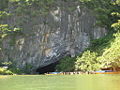
The mouth of Phong Nha cave with underground river
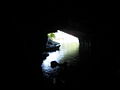
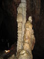
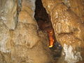
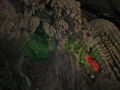
Inside Phong Nha Cave in the Phong Nha Ke Bang
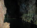
Underground river
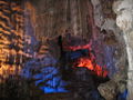
Inside scene of the cave
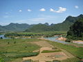
Part of Phong Nha-Ke Bang National Park
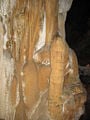
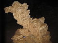
Stalactites in the Dry Cave of Phong Nha Ke Bang National Park
Phong Nha Ke Bang National Park
Phong Nha Ke Bang National Park
Phong Nha Ke Bang National Park
Phong Nha Ke Bang National Park


Notes
- ↑ 1.00 1.01 1.02 1.03 1.04 1.05 1.06 1.07 1.08 1.09 1.10 Phong Nha-Ke Bang National Park. United Nations Environment Programme (March 2003). Retrieved 2008-08-03. Cite error: Invalid
<ref>tag; name "unep-wcmc" defined multiple times with different content - ↑ World Heritage Nomination, IUCN Technical Evaluation; Phong Nha-Ke Bang National Park, p. 53, 54, 55 (PDF). IUCN. Retrieved 2008-08-03.
- ↑ 3.0 3.1 3.2 Di sản thiên nhiên thế giới - Vườn quốc gia Phong Nha - Kẻ Bàng (Quảng Bình). Vietnam Geological and Mineral Resources Department (2006-07-23). Retrieved 2008-08-04.
- ↑ Decision by the Vietnamese Prime Minister on establishment of Phong Nha-Ke Bang National Park. nea.gov (2001-12-12). Retrieved 2008-08-03.
- ↑ Phát hiện mới ở Phong Nha. Tuổi Trẻ (2008-01-25). Retrieved 2008-08-03.
- ↑ Di sản thiên nhiên Phong Nha Kẻ Bàng. Peacetourco. Retrieved 2008-08-03.
- ↑ 7.0 7.1 Phong Nha-Ke Bang National Park. UNESCO (2003). Retrieved 2008-08-04.
- ↑ Phong Nha Cave. Traveltovietnam. Retrieved 2008-02-28.
- ↑ 9.0 9.1 The Encyclopedia Earth Cite error: Invalid
<ref>tag; name "eoearth" defined multiple times with different content - ↑ New Lizards Species Found. reptiles.swelluk (2007-09). Retrieved 2008-02-22.
- ↑ New species found in Vietnam. practicalfishkeeping (2004-02-19). Retrieved 2008-02-22.
- ↑ 12.0 12.1 12.2 12.3 Bird Life Indochina, Birding Center in Vietnam. Retrieved August 3, 2008. Cite error: Invalid
<ref>tag; name "birdlifeindochina" defined multiple times with different content - ↑ 13.0 13.1 http://bauchon.tuoitre.com.vn/Tianyon/Index.aspx?ArticleID=241634&ChannelID=458 "Cái nôi" văn hóa và lịch sử Phong Nha - Kẻ Bàng]. Retrieved August 3, 2008. Cite error: Invalid
<ref>tag; name "bauchon458" defined multiple times with different content - ↑ http://www.thiennhien.net/news/155/ARTICLE/3731/2007-11-30.html
- ↑ Thú rừng Phong Nha - Kẻ Bàng ngắc ngoải kêu cứu...trong nồi (wild animals in Phong Nha-Ke Bang forest are dying in cooks)
- ↑ Phong Nha – Ke Bang: wild animals cry for help. Vietnamnet (2005-10-24). Retrieved 2008-02-28.
- ↑ Thượng sơn hỏi chuyện “Đệ nhất cá chình”. Tiền Phong (2006-12-29). Retrieved 2008-02-26.
- ↑ Vietnam: Road-building threatens Phong Nha Nature Reserve
- ↑ BirdLife IBA Factsheet. BirdLide. Retrieved 2008-02-26.
- ↑ Rừng vùng đệm Phong Nha- Kẻ Bàng bị tàn phá. báo Tiền Phong (2006-11-16). Retrieved 2008-02-22.
- ↑ Phong Nha - Kẻ Bàng đang bị 'băm nát'. vnexpress (2004-08-10). Retrieved 2008-02-26.
- ↑ Hãy bảo vệ Phong Nha – Kẻ Bàng. quangbinhonline (2007-11-12). Retrieved 2008-02-26.
- ↑ Phong Nha – Kẻ Bàng: Ngổn ngang chờ quy hoạch. Ministry of Culture, Sports and Toursim of Vietnam (2005-12-01). Retrieved 2008-02-22.
- ↑ Chuyện lạ ở Phong Nha-Kẻ Bàng. Báo Sài Gòn Giải Phóng (2006-11-28). Retrieved 2008-02-22.
- ↑ Thuê chuyên gia nước ngoài quy hoạch Phong Nha-Kẻ Bàng. didulich.net (2007-09-07). Retrieved 2008-02-22.
- ↑ Đức giúp Vườn quốc gia Phong Nha – Kẻ Bàng (Germany donates to Phong Nha-Ke Bang National Park). German Embassy in Vietnam (2005-11-03). Retrieved 2008-02-26.
- ↑ Germany helps preserve Phong Nha-Ke Bang park. Việt Nam News (25 January, 2007). Retrieved 2008-02-14.
- ↑ Đức ủng hộ gần 2 triệu euro cho Vườn Quốc gia Phong Nha Kẻ Bàng. dantri (2007-10-23). Retrieved 2008-02-24.
- ↑ FFI hỗ trợ bảo tồn loài linh trưởng ở Phong Nha Kẻ Bàng. [ISGE. Retrieved 2008-02-24.
ReferencesISBN links support NWE through referral fees
- Eames J. C., Lambert F. R. and Nguyen Cu. (1995). Rediscovery of the Sooty Babbler Stchyris herberti in central Vietnam. Bird Conservation International. 5: 129- 135.
- Nguyen Binh. (1961). Brief Introduction of Mountainous Minority People of Quang Binh Province. Ethnology 23, Hanoi.
- Nguyen Quang My & Limbert, Howard. (2002). Ky Quan Hang Dong Vietnam (The Wonders of Vietnamese Caves). Trung Tam Ban Do Va tranh Anh Giao Duc, Hanoi.
- Ovel, C. and Nguyen Thi Dao. (1998). LINC: linking Him Namno and Phong Nha through parallel conservation: phase 1 Phong Nha Ke-Bang Nature Reserve, Vietnam Draft project document. WWF Indochina Programme, Hanoi.
- Meijboom, M. & Ho Thi Ngoc Lanh. (2002). He Dong - Thuc Vat / O Phong Nha - Ke Bang Va Hin Namno. Phong Nha-Ke Bang National Park with WWF, Hanoi.
- Timmins, R. J., Do Tuoc, Trinh Viet Cong and D. K. Hendrichson. (1999). Preliminary Assessment of the Conservation Importance and Conservation Priorities of the Phong Nha-Ke Bang Proposed National Park, Quang Binh Province, Vietnam. Fauna and Flora International - Indochina Programme, Hanoi.
External links
- UNESCO World Heritage page for Phong Nha-Ke Bang. Retrieved August 3, 2008.
- See pictures of Phong Nha Ke Bang. Retrieved August 3, 2008.
- Phong Nha-Ke Bang on Thanhniennews in English. Retrieved August 3, 2008.
- "Amazing natural beauty of Phong Nha-Ke Bang," Vietnamnet News. Retrieved August 3, 2008.
| ||||||||||
| |||||
Credits
New World Encyclopedia writers and editors rewrote and completed the Wikipedia article in accordance with New World Encyclopedia standards. This article abides by terms of the Creative Commons CC-by-sa 3.0 License (CC-by-sa), which may be used and disseminated with proper attribution. Credit is due under the terms of this license that can reference both the New World Encyclopedia contributors and the selfless volunteer contributors of the Wikimedia Foundation. To cite this article click here for a list of acceptable citing formats.The history of earlier contributions by wikipedians is accessible to researchers here:
The history of this article since it was imported to New World Encyclopedia:
Note: Some restrictions may apply to use of individual images which are separately licensed.