|
|
| (87 intermediate revisions by 6 users not shown) |
| Line 1: |
Line 1: |
| | + | {{approved}}{{submitted}}{{ready}}{{images OK}}{{copyedited}} |
| | {{Infobox World Heritage Site | | {{Infobox World Heritage Site |
| | | WHS = Phong Nha-Ke Bang National Park | | | WHS = Phong Nha-Ke Bang National Park |
| − | | Image = [[Image:Phongnhacave.jpg|right|200px|Phong Nha Cave]] | + | | Image = [[Image:Phongnhacave.jpg|250px|Phong Nha Cave]] |
| | | State Party = {{VIE}} | | | State Party = {{VIE}} |
| | | Type = Natural | | | Type = Natural |
| Line 11: |
Line 12: |
| | | Link = http://whc.unesco.org/en/list/951 | | | Link = http://whc.unesco.org/en/list/951 |
| | }} | | }} |
| − | {{Infobox_protected_area | name = Phong Nha-Ke Bang National Park
| |
| − | | iucn_category = II
| |
| − | | image = Vietnam-locator.png
| |
| − | | caption =
| |
| − | | locator_x = 153
| |
| − | | locator_y = 235
| |
| − | | location = [[Quang Binh Province]], [[Bac Trung Bo|North central Vietnam]]
| |
| − | | nearest_city = [[Dong Hoi]]
| |
| − | | lat_degrees =17
| |
| − | | lat_minutes =32
| |
| − | | lat_seconds =14
| |
| − | | lat_direction =N
| |
| − | | long_degrees =106
| |
| − | | long_minutes =9
| |
| − | | long_seconds =4.5
| |
| − | | long_direction =E
| |
| − | | area = 857.54 km²
| |
| − | | established = 2001
| |
| − | | visitation_num =
| |
| − | | visitation_year =
| |
| − | | governing_body = [[People's Committee (Vietnam)|People Committee]] of [[Quang Binh Province]]
| |
| − | }}
| |
| − |
| |
| − | '''Phong Nha - Ke Bang''' ([[Vietnamese language|Vietnamese]]: ''Vườn quốc gia Phong Nha-Kẻ Bàng'') is a [[national park]] and [[UNESCO]] [[World Heritage Site]] in the [[Bo Trach|Bố Trạch]] and [[Minh Hoa|Minh Hóa]] districts of central [[Quang Binh Province]], in [[Bac Trung Bo|north-central]] [[Vietnam]], about 500 km south of the nation's capital, [[Hanoi]]. The park borders the [[Hin Namno|Hin Namno Nature Reserve]] in the [[provinces of Laos|province]] of [[Khammouan]], [[Laos]] by the west, 42 km east of [[South China Sea]] from its point. Phong Nha-Ke Bang National Park is situated in a limestone zone of 200,000 hectare in Vietnamese territory and borders another limestone zone of 200,000 hectares of [[Hin Namno]] in [[Laos|Laotian]] territory. The core zone of this national park covers 85,754 hectares and a buffer zone of 195,400 ha.<ref name="unep-wcmc">{{Cite web|title=Phong Nha-Ke Bang National Park |url=http://www.unep-wcmc.org/sites/wh/Phong_nha.html |publisher=[[United Nations Environment Programme]]| year=2003 |month=March |accessdate=2008-02-21}}</ref> The park was created to protect one of the world's two largest [[Karst topography|karst]] regions with 300 caves and [[grotto]]es and also protects the [[ecosystem]] of [[limestone]] forest of the [[Annamite Range]] region in [[Bac Trung Bo|north central coast]] of Vietnam.
| |
| − | <ref name="uhc.unesco">{{cite web|url=http://whc.unesco.org/archive/advisory_body_evaluation/951rev.pdf|title=World Heritage Nomination, IUCN Technical Evaluation; Phong Nha-Ke Bang National Park, p. 53, 54, 55|work=[[IUCN]]|date=|accessdate=2008-02-28|format=PDF}}</ref><ref name="dgmv">{{cite web| title=Di sản thiên nhiên thế giới - Vườn quốc gia Phong Nha - Kẻ Bàng (Quảng Bình) |url=http://www.idm.gov.vn/Nguon_luc/Xuat_ban/Anpham/Phongnha/T189.htm|publisher=[[Politics of Vietnam|Vietnam Geological and Mineral Resources Department]]|date=2006-07-23| accessdate=2008-02-26}}</ref>
| |
| − |
| |
| − | Phong Nha-Ke Bang area is noted for its cave and grotto systems as it is composed of 300 caves and grottos with a total length of about 70 km, of which only 20 have been surveyed by Vietnamese and British scientists; 17 of these are in located in the Phong Nha area and three in the Ke Bang area. Phong Nha holds several world cave records, as it has the longest underground river, as well as the largest caverns and passageways.<ref name="unep-wcmc"/>
| |
| − |
| |
| − | The park derives it name from Phong Nha cave, the most beautiful of all, containing many fascinating rock formations, and Ke Bang forest.<ref name="peacetourco">{{cite web|url=http://www.peacetourco.com/index.php?option=com_content&task=view&Itemid=158&id=68&lang=en|title=Phong Nha Ke Bang National Park in central Quang Binh|publisher=Peacetourco|accessdate=2008-02-28}}</ref>
| |
| − |
| |
| − | The plateau on which the park is situated is probably one of the finest and most distinctive examples of a complex [[Karst topography|karst]] landform in Southeast Asia.<ref name="unesco">{{cite web|url=http://whc.unesco.org/en/list/951|title=Phong Nha-Ke Bang National Park|publisher=[[UNESCO]]|date=2003|accessdate=2008-02-28}}</ref>
| |
| − |
| |
| − | This national park was listed in [[UNESCO]]’s World Heritage Sites in 2003 for its geographical values as defined in its criteria viii.<ref name="unesco"/>
| |
| − |
| |
| − | ==History of exploration==
| |
| − | [[Champa]] inscriptions carved on [[stele]]s and altars in the cave demonstrate that people had inhabited the cave long before the area was annexed by Vietnam in the [[nam tien]] southward expansion.
| |
| | | | |
| − | In 1550, [[Dương Văn An]] was the first Vietnamese man to write about Phong Nha cave. Phong Nha cave was depicted in [[Nine Urns (Huế)|9 urns]] in the Citadel of the [[Nguyễn Dynasty|Nguyen Dynasty]] in [[Huế]].<ref name="unep-wcmc"/>
| + | '''Phong Nha-Ke Bang''' ([[Vietnamese language|Vietnamese]]: ''Vườn quốc gia Phong Nha-Kẻ Bàng'') is one of the world's largest [[Karst topography|karst]] regions with 300 caves and [[grotto]]es. They extend about {{convert|70|km|mi}} with the world's longest underground river, as well as the largest caverns and passageways ever discovered. The government of [[Vietnam]] declared Phong Nha-Ke Bang a [[national park]] in 2001 to protect the [[cave]] and grotto system as well as the [[ecosystem]] of the [[limestone]] [[forest]] there. Some of the [[evergreen tree]]s are dated at 500 to 600 years old. Among the hundreds of types of [[flora]], thirty six endangered species thrive. [[Fauna]] abounds throughout the park as well, including twenty three [[endangered species]] and sixty six receiving special protection from the Vietnamese government. |
| | + | {{toc}} |
| | + | The region is also important as an [[archeology|archeological]] site. [[Neolithic]] [[artifact]]s have been found from [[Vietnam]]'s prehistoric period as well as excellent samples of [[hieroglyphic]] script of the [[Cham]] tribe. It is thought by some archeologists that the [[Bi Ky grotto]] may have housed a [[Champa mosque]] during the ninth through eleventh centuries. [[Champa inscriptions]] from early Vietnamese history have been carved on [[steles]] and [[altars]]. Champa-style [[ceramics]] as well have been discovered there. [[UNESCO]] declared Phong Nha-Ke Bang a [[World Heritage Site]] in 2003.<ref name=UNESCO>[https://whc.unesco.org/en/list/951/ Phong Nha-Ke Bang National Park] ''UNESCO World Heritage Convention''. Retrieved September 18, 2023.</ref> |
| | | | |
| − | In 1824, Phong Nha cave was conferred the title "Diệu ứng chi thần" ([[Hán tự|Han Tu]]: 妙應之神) by king [[Minh Mang]]. It was also conferred by Nguyen kings as "Thần Hiển Linh" (Han Tu: 神顯靈).<ref name="dainamnhatthongchi"/>
| + | ==Location== |
| | + | Phong Nha-Ke Bang is located in the [[Bo Trach|Bố Trạch]] and [[Minh Hoa|Minh Hóa]] districts of central [[Quang Binh Province]], in [[Bac Trung Bo|north-central]] [[Vietnam]], about 500 kilometers south of the nation's capital, [[Hanoi]]. The park borders the [[Hin Namno|Hin Namno Nature Reserve]] in the [[provinces of Laos|province]] of [[Khammouan]], [[Laos]] by the west, forty two kilometers east of [[South China Sea]]. Phong Nha-Ke Bang National Park is located in a limestone zone of 200,000 hectare in Vietnamese territory and borders another limestone zone of 200,000 hectares of Hin Namno in Laotian territory. The core zone of the national park covers 85,754 hectares and the total property comprises an area of 123,326 ha.<ref name=UNESCO/> |
| | | | |
| − | In the late 19th century, [[Léopold Michel Cadière]], a French Catholic priest, conducted an expedition to explore Phong Nha cave, where he discovered Champa scripts. He proclaimed Phong Nha cave "The number one cave of Indochina"<ref name="dgmv"/>. In July 1924, an English expeditionist, Barton, stated that Phong Nha cave is second to none of famous caves of [[Padirac]] (France), [[Cuevas del Drach]] (Spain) as far as the beauty and miracles are concerned.<ref name="nea"/><ref name="unep-wcmc"/>
| + | ==Exploration== |
| | + | [[Image:LocationVietnamQuangNinh.png|thumb|right|300px|Quang Ninh Province]] |
| | | | |
| − | In 1935, a local inhabitant accidentally discovered a beautiful cave 1 km from Phong Nha cave mouth, at an elevation of 200 m. It was called Tien Son cave (lit.: ''Fairy-tale cave''), or Dry cave due to the fact that its inside landscape is similar to fairy-tales and it has no underground river.<ref name="dattroivietnam"/> | + | [[Champa]] inscriptions carved on [[stele]]s and altars in the cave give evidence that people had inhabited the cave long before Vietnam annexed the area in the Nam Tien southward expansion. In 1550, [[Dương Văn An]] became the first Vietnamese man to write about Phong Nha cave. Phong Nha cave has been depicted in [[Nine Urns (Huế)|nine urns]] in the Citadel of the [[Nguyễn Dynasty|Nguyen Dynasty]] in [[Huế]].<ref name="unep-wcmc">[https://web.archive.org/web/20081115021650/http://www.unep-wcmc.org/sites Phong Nha-Ke Bang National Park] ''United Nations Environment Programme''. Retrieved September 18, 2023.</ref> In 1824, king [[Minh Mang]] conferred the title "Diệu ứng chi thần" ([[Hán tự|Han Tu]]: 妙應之神) on Phong Nha cave. Nguyen kings bestowed the title "Thần Hiển Linh" (Han Tu: 神顯靈). |
| | | | |
| − | In 1937, the Bureau of Tourism of [[French Resident Superior]] (in [[Huế]]) issued a brochure to introduce tourism in Quang Binh and Phong Nha Cave was included in this introduction. This tour site is ranked second in [[French Indochina]]. Before 1990, several explorations were conducted by Vietnamese and foreign groups but the mystery of this area still remained. From 1990 on, there marked a turning point in discovering activities, from exploration to research, thus full documents for submission to UNESCO for World Natural Heritage nomination were made available. | + | In the late nineteenth century, [[Léopold Michel Cadière]], a French Catholic priest, conducted an expedition to explore Phong Nha cave, in which he discovered Champa scripts. He proclaimed Phong Nha cave "the number one cave of Indochina."<ref name="dgmv">[http://www.idm.gov.vn/Nguon_luc/Xuat_ban/Anpham/Phongnha/T189.htm Di sản thiên nhiên thế giới - Vườn quốc gia Phong Nha - Kẻ Bàng (Quảng Bình)] 'Vietnam Geological and Mineral Resources Department''. Retrieved September 18, 2023.</ref> In July 1924, an English expeditionist, Barton, declared Phong Nha cave second to neither of famous caves of [[Padirac]] (France), or [[Cuevas del Drach]] (Spain) in respect to beauty.<ref name=<ref name="unep-wcmc"/> |
| | | | |
| − | For the first time in 1990, [[Vietnam National University, Hanoi|Hanoi University]] accepted the cooperation proposal of the [[British Cave Research Association]]. They combined efforts in exploring and researching caves and grottoes in the area comprehensively. The first exploration was conducted in 1990 by a group from the British Cave Research Association and Faculty for Geology and Geography of [[Vietnam National University, Hanoi|Hanoi University]], led by Howard Limbert. They completed research of a large part of Vom Cave.
| + | In 1935, a local inhabitant accidentally discovered a beautiful cave one kilometer from Phong Nha cave mouth, at a depth of 200 meters. The cave received the name Tien Son cave (lit.: ''Fairy-tale cave''), or Dry cave because of the lack of an underground river. In 1937, the Bureau of Tourism of [[French Resident Superior]] (in [[Huế]]) issued a brochure to promote tourism in Quang Binh, introducing Phong Nha Cave in the brochure. Before 1990, Vietnamese and foreign groups conducted several explorations. From 1990 the number of discovery and research expeditions increased dramatically, leading to a drafting of documents recommending the site as a [[UNESCO]] for World Natural Heritage designation. |
| | | | |
| − | In 1992, the second exploration was conducted by a group of 12 British scientists, six professors from [[Vietnam National University, Hanoi|Hanoi University]]. This time, this group completed their exploration of 7,729 m of Phong Nha Cave and 13,690 m of Vom Cave and adjacent caves and grottos. In 1994, a third exploration was carried out by a group of 11 British scientists and five Vietnamese professors of [[Vietnam National University, Hanoi|Hanoi University]].
| + | ==Geography and climate== |
| − | | + | [[Image:Phongnha17.jpg|thumb|400px|Inside Phong Nha Cave.]] |
| − | In 1999 scientists from the [[Vietnam-Russia Tropical Centre]] also conducted zoological and botanical surveys in the Ke Bang area.<ref name="unep-wcmc"/>
| + | The Vietnamese government officially declared the Phong Nha Nature Reserve on August 9, 1986, designating an area of 5,000 ha, later extending that to 41,132 ha by 1991. On December 12, 2001, the Vietnamese Prime Minister announced upgrading the nature reserve to a national park to protect the biodiversity of the park, especially rare species of fauna and flora native to the region. The park covers a total area of 857.54 square kilometers divided into three zones, a "strictly protected zone" (648.94 km²), an "ecological recovery zone" (174.49 km²), and an "administrative service zone" (34.11 km²). |
| − | | |
| − | From the results of these three explorations, more thorough knowledge of the cave and grotto systems in this park was made available to the Vietnamese and local government for the protection, planning, and tourism development of this park.<ref name="dgmv"/>
| |
| − | | |
| − | In 2005, scientists from the [[British Cave Research Association]] discovered a new cave and named it '''Paradise Cave''' (''động Thiên Đường''). The newly discovered cave was acclaimed by the British scientists as "the largest and the most beautiful cave in Phong Nha-Ke Bang area".<ref name="vietnamopentour">{{cite web| title=Khám phá động Thiên Đường (Discover the Paradise Cave|url=http://www.vietnamopentour.com.vn/cms/articles/809/1/%20Kham-pha-dong-Thien-Duong|date=| accessdate=2008-02-22}}</ref><ref name="vietbao19-7-05">{{cite web| title=Phát hiện hang động lớn nhất tại Phong Nha-Kẻ Bàng (Largest cave found in Phong Nha-Ke Bang|url=http://vietbao.vn/Khoa-hoc/Phat-hien-hang-dong-lon-nhat-tai-Phong-Nha-Ke-Bang/10918592/188/|date=2005-07-19| accessdate=2008-02-22}}</ref>
| |
| − | | |
| − | On June 1, 2006, the Ministry of Culture and Information of Vietnam issued a stamp collection of depicting various landscapes found in Phong Nha-Ke Bang.<ref name="xahoithongtin">{{cite web| title=Phát hành bộ tem "Phong Nha - Kẻ Bàng" (Collection of Phong Nha-Ke Bang stamp issued)|url=http://www.xahoithongtin.com.vn/index.asp?ID=55&subjectID=8345|date=2006-06-19| accessdate=2008-02-22}}</ref>
| |
| − | | |
| − | ==Geography==
| |
| − | ===Location===
| |
| − | [[Image:Phongnha17.jpg|200px|thumb|right|Inside Phong Nha Cave]] | |
| − | Phong Nha - Ke Bang National Park is located in the territories of communes ({{vi}}: ''xã''): Tan Trach, Thuong Trach, Phuc Trach, Xuan Trach and Son Trach of [[Bo Trach]] district and a small part of [[Minh Hoa]] district in the center of [[Quang Binh Province|Quang Binh province]], around 40 km north-west of the provincial capital city of [[Dong Hoi]]. The park is bordered by [[Hin Namno]] karst area of [[Khammouan]] Province of [[Laos]] in the west. The road distances are about 500 km south of the capital [[Hanoi]] and 260 km north of the port city of [[Da Nang]]. The [[Geographic coordinate system|geographical coordinates]] are {{coor dms|17|32|14|N|106|9|4.5|E}}.<ref name="nea">{{cite web| title=Decision by the Vietnamese Prime Minister on establishment of Phong Nha-Ke Bang National Park|url=http://www.nea.gov.vn/luat/toanvan/QD_189-2001_QD-TTg.htm |publisher=nea.gov|date=[[2001-12-12]]| accessdate=2008-02-24}}</ref>
| |
| − | | |
| − | The park is situated around 30 km west of [[South China Sea]] and [[National Road 1A (Vietnam)|National Road 1A]], near [[Ho Chi Minh Highway]] and 28 km west of [[North-South Railway, Vietnam|Hanoi-Saigon Railway]] and is accessed by road or waterway by boat through the estuary in South China Sea upwards. There is a small airport near the park accessible by helicopter or small aircraft (Khe Giat Airbase), an airbase used by North Vietnamese Air Force during [[Vietnam War]], notably in the [[Battle of Dong Hoi]]. | |
| − | | |
| − | ===Park layout===
| |
| − | Before becoming a national park, this area had been a nature reserve. The Phong Nha Nature Reserve with an area of 5,000 ha was officially declared by the Vietnamese government on 9 August 1986 and was extended to 41,132 ha by 1991. On [[December 12]], 2001, the Vietnamese Prime Minister by Decision 189/2001 189/2001/QĐ-TTG turning then a nature reserve into a national park.<ref name="nea"/> The purpose of this protected area is to protect forest resources, biodiversity within the boundary of this national park and to preserve scientific values of fauna and flora in [[Bac Trung Bo]] region, especially rare species native to this region.
| |
| − | | |
| − | The park covers a total area of 857.54 km² which are divided into three zones, a "strictly protected zone" (648.94 km²), an "ecological recovery zone" (174.49 km²), and an "administrative service zone" (34.11 km²).<ref name="nea"/> | |
| | | | |
| | ===Climate=== | | ===Climate=== |
| − | Like [[Bac Trung Bo]] in general and [[Quang Binh Province]] in particular, the climate in this national park is tropical, hot, and humid. The annual mean temperature is 23 to 25 °C, with a maximum of 41 °C in the summer and a minimum of 6 °C in the winter. The hottest months in this region fall from June to August, with an average temperature of 28 °C, and the coldest months from December to February with an average temperature of 18 °C. Annual rainfall is 2,000 mm to 2,500 mm, and 88% of the rainfall is from July to December. With more than 160 rainy days per year, no month is without rain. Mean annual relative humidity is 84%.<ref name="unep-wcmc"/>
| + | The national park has a tropical, hot, and humid climate with an annual mean temperature of 23 to 25 °C, a maximum temperature of 41 °C in the summer and a minimum of 6 °C in the winter. The hottest months fall between June to August, with an average temperature of 28 °C, and the coldest months from December to February, with an average temperature of 18 °C. Annual rainfall measures 2,000 mm to 2,500 mm, and 88 percent of the rainfall between July to December. Mean annual relative humidity measures 84 percent. |
| | | | |
| − | ===History of formation=== | + | ===Geological formation=== |
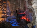
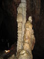
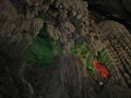
| − | The Phong Nha–Ke Bang karst has evolved since the [[Paleozoic]] (some 400 million years ago) and so is the oldest major [[karst]] area in Asia. It has been subject to massive tectonic changes, and comprises a series of rock types that are interbedded in complex ways. Probably as many as seven different major levels of karst development have occurred as a result of tectonic uplift and changing sea levels, thus the karst landscape of PNKB is extremely complex with high geodiversity and many geomorphic features of considerable significance. Like much of Vietnam, it has been subject to extensive tectonic change, and so the limestones of Phong Nha are inter-bedded with a number of other rocks. There is also strong evidence that sulphurous solution and hydrothermal action have played an important role in shaping the broad-scale landscape and the caves, though this has not yet been properly assessed. <ref name="uhc.unesco"/> | + | [[Image:Phongnhakebang15.jpg|400px|thumb|right|A scene inside Phong Nha Cave, the most beautiful caves in Phong Nha Ke Bang National Park]] |
| | + | The Phong Nha–Ke Bang karst has evolved since the [[Paleozoic]] (some 400 million years ago), the oldest major [[karst]] area in Asia. Massive tectonic changes, comprising a series of rock types that inter-bed in complex ways, have occurred. As many as seven different major levels of [[karst]] development have occurred as a result of tectonic uplift and changing sea levels, making the karst landscape of the park extremely complex with high a [[geodiversity]] and many geomorphic features. Like much of Vietnam, the [[limestone]]s of Phong Nha have inter-bedded with a number of other rocks. Investigations point to sulfurous solution and hydrothermal action playing an important role in shaping the broad-scale landscape and the caves. |
| | + | [[Image:Phongnhakebang8.jpg|400px|thumb|right|Spectacular stalagmite in a cave in the Phong Nha Ke Bang National Park.]] |
| | | | |
| − | Phong Nha-Ke Bang area today is a result of 5 stages of Earth's crust development and movement in this area:<ref name="dgmv"/>
| + | Five stages of the Earth's crust development and movement impacted Phong Nha-Ke Bang: Late Ordovician-Early Silurian Stage (about 450 Ma), Middle-late Devonian Stage (about 340 Ma), Carboniferous-Permian (about 300 Ma), Mesozoic Orogenic stage, and Cenozoic stage. Phong Nha-Ke Bang also contains two dozen mountain peaks over 1,000 meters high. Noteworthy peaks include the Peak Co Rilata with a height of 1,128 meters and the Peak Co Preu with a height of 1,213 meters. |
| − | *Late Ordovician - Early Silurian Stage (about 450 Ma)
| + | [[Image:Phongnhakebang1.jpg|400px|thumb|right|Son River in the Phong Nha Ke Bang National Park]] |
| − | *Middle-late Devonian Stage (about 340 Ma)
| |
| − | *Carboniferous-Permian (about 300 Ma)
| |
| − | *Mesozoic Orogenic stage
| |
| − | *Cenozoic stage.
| |
| | | | |
| − | ===Geological significance===
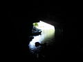
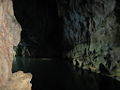
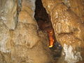
| + | Besides the grotto and cave systems, Phong Nha has the longest underground river in the world. The [[Son River|Son]] and [[Chay River|Chay]] are the main rivers in the national park. Most of caves have been shaped by Son and Chay Rivers. The Son River flows into the mouth of the Phong Nha cave and continues underground. Called the Nam Aki River, it emerges 20 kilometers to the south near Pu-Pha-Dam Mountain. Ten spectacular streams, springs and waterfalls exist in Phong Nha-Ke Bang area, namely: Gió waterfall, Madame Loan waterfall, Mọc stream erupting from a limestone mount range, and Trạ Ang stream. |
| − | Phong Nha-Ke Bang National Park is one of the world's two largest [[limestone]] regions. In comparison with 41 other world heritage sites which have karsts, Phong Nha has dissimilar geomorphic, geologic and biotic conditions. The karsts of Phong Nha can be traced back to [[Paleozoic|Palaeozoic]] era, 400 million years ago. This makes Phong Nha the oldest major karst in Asia. If the [[Hin Namno]], bordering Phong Nha on the west (in [[Laos|Laotian]] territory) was to be combined with the national park in a continuous reserve, the combined reserve would be the largest surviving karst forest in South-east Asia (317,754 ha). | |
| | | | |
| − | In general, there are two groups of [[landform]]s in the Phong Nha - Kẻ Bàng area, namely non-karstic and karstic landforms. Non-karstic landforms includes three types: The middle and low dome-block mountains developed in intrusive magmatic massifs; The middle denudation-structural mountain belts developed in terrigenous rocks of Cretaceous age; and The low block-denudational mountain belts developed in other terrigenous rocks.
| + | [[Image:Phongnhakebang14.jpg|400px|thumb|right|Underground river in Phong Nha cave]] |
| − | | + | Phong Nha-Ke Bang covers 300 different grottoes and caves. Phong Nha cave has been evaluated as the top cave in the world due to its four records: the longest underground river, the highest and longest cave, broadest and most beautiful fine sand beaches inside the caves, the most spectacular stalagmites and stalactites.<ref name="ngaynay">[https://web.archive.org/web/20081211055018/http://www.peacetourco.com/index.php?option=com_content&task=view&Itemid=158&id=68&lang=en Di sản thiên nhiên Phong Nha Kẻ Bàng] ''Peace Tour Co.'' Retrieved September 18, 2023.</ref> According to the assessment of [[UNESCO]], "The karst formation of Phong Nha-Ke Bang National Park has evolved since the Paleozoic (some 400 million years ago) and so is the oldest major karst area in Asia"> and "Phong Nha displays an impressive amount of evidence of earth’s history. It is a site of very great importance for increasing our understanding of the geologic, geomorphic and geo-chronological history of the region."<ref name=UNESCO/> |
| − | Karstic landforms in this area are of typical tropical karst which are divided into two groups of forms: The karstic forms on the surface including cone and tower karst, karrens, valleys and dolines, border polje, etc; The underground karst consisting of caves. <ref name="dgmv"/>
| |
| − | | |
| − | In comparison with three other national parks listed in UNESCO's World Heritage Sites in Southeast Asia, namely [[Gunung Mulu National Park]] in [[Malaysia]], [[Puerto Princesa Subterranean River National Park]] in [[Palawan]] of the [[Philippines]] and [[Lorentz National Park]] in [[Western New Guinea|West Irian]] of [[Indonesia]] and some other karst regions in [[Thailand]], [[China]], [[Papua New Guinea]], [[Karst topography|karst]] in Phong Nha-Ke Bang is older, has more complicated geological structure; diverse and complex underground rivers. <ref name="uhc.unesco">{{cite web|url=http://whc.unesco.org/archive/advisory_body_evaluation/951rev.pdf|title=World Heritage Nomination, IUCN Technical Evaluation; Phong Nha-Ke Bang National Park, p. 53, 54, 55|work=[[IUCN]]|date=|accessdate=2008-02-28|format=PDF}}</ref>
| |
| − | | |
| − | [[Image:Phongnhakebang15.jpg|200px|thumb|right|A scene inside Phong Nha Cave, the most beautiful caves in Phong Nha Ke Bang National Park]] | |
| − | [[Image:Phongnhakebang8.jpg|200px|thumb|right|Spectacular stalagmite in a cave in the Phong Nha Ke Bang National Park]]
| |
| − | | |
| − | ===Mounts and summits===
| |
| − | Phong Nha - Ke Bang also contains two dozens of mountain peaks with over 1,000 metres in height. Noteworthy peaks are the Peak Co Rilata with ta height of 1,128 m and the Peak Co Preu with a height of 1,213 m.<ref name="unep-wcmc">[http://www.unep-wcmc.org/sites/wh/Phong_nha.html United Nations Environment Programme, World Conservation Monitoring Centre]</ref>
| |
| − | | |
| − | Mounts in [[Karst topography|karst]]ic area of the park rise at typical height of above 800 m constitute a continuous range along Laotian-Vietnamese borderline, of which notable summits above 1000 m are: Phu Tạo (1174 m), Co Unet (1150 m), Phu Canh (1095 m), Phu Mun (1078 m), Phu Tu En (1078 m), Phu On Chinh (1068 m), Phu Dung (1064 m), Phu Tu Ôc (1053 m), Phu Long (1015 m), Phu Ôc (1015 m), Phu Dong (1002 m). Inserting into these summits are 800-1000 m high summits of Phu Sinh (965 m), Phu Co Tri (949 m), Phu On Boi (933 m), Phu Tu (956 m), Phu Toan (905 m), Phu Phong (902 m), núi Ma Ma (835 m).
| |
| − | | |
| − | Non-[[Karst topography|karst]]ic topograhical area accounts for a low percentage, distributing mainly in outer circle of limestone in the north, northeast and southeast of this national park. The height of these summits varies from 500-1000 m with the deep divisions and high sloping level from 25-30o. There are some narrow valleys along streams such as Am creek, Cha Lo creek, Chua Ngút creek and a valley along Rao Thuong river in the southernmost edge. In the north-south direction, there exists notable summits: Phu Toc Vu (1000 m), Mã Tác (1068 m), Cổ Khu (886 m), U Bò (1009 m), Co Rilata (1128 m); The highest summit in the non-karstic area and also the highest summt of this national park is Co Preu (1213 m), a summit in the southernmost edge of the park.<ref name="dgmv"/>
| |
| − | | |
| − | ===Rivers and streams===
| |
| − | [[Image:Phongnhakebang1.jpg|200px|thumb|right|Son River in the Phong Nha Ke Bang National Park]]
| |
| − | [[Image:Phongnhakebang14.jpg|200px|thumb|left|Underground river in Phong Nha cave]]
| |
| − | Besides the grotto and cave systems, Phong Nha has the longest underground river. The [[Son River|Son]] and [[Chay River|Chay]] are the main rivers in this national park. Most of caves here have been shaped by Son and Chay Rivers. The Son River flows into the mouth of the Phong Nha cave and keeps on underground, where it is called as the Nam Aki River. It emerges 20 km to the south near Pu-Pha-Dam Mountain.<ref name="traveltovietnam"/>
| |
| − | | |
| − | There are over ten spectacular streams, springs and waterfalls in Phong Nha-Ke Bang area, namely: Gió waterfall, Madame Loan waterfall, Mọc stream erupting from a limestone mount range, and Trạ Ang stream.<ref name="Tuổi Trẻ 25-1-2008">{{Cite web|url=http://www.tuoitre.com.vn/Tianyon/Index.aspx?ArticleID=240340&ChannelID=481|title=Phát hiện mới ở Phong Nha|work=[[Tuoi Tre|Tuổi Trẻ]]|date=2008-01-25|accessdate=2008-01-25}}</ref>
| |
| − | | |
| − | ==Cave and grottoes==
| |
| − | Phong Nha-Ke Bang covers 300 different grottoes and caves. Phong Nha cave is assessed by BCRA as the top cave in the world due to its 4 top records: the longest underground river, the highest and longest cave, broadest and most beautiful fine sand beaches inside the caves, the most spectacular stalagmites and stalactites.<ref name="ngaynay">{{cite web|url=http://www.ngaynay.com.vn/index.php?id=427&option=com_content&task=view|title=Di sản thiên nhiên Phong Nha Kẻ Bàng|publisher=Peacetourco|accessdate=2008-02-28}}</ref><ref name=mientrung">{{cite web|url=http://www.mientrung.com/content/view/160/129|title=Bảy cái nhất của động Phong Nha cần khám phá trong hè này|publisher=Peacetourco|date=2004-06-01|accessdate=2008-02-28}}</ref><ref name="peacetourco"/> | |
| − | | |
| − | According to the assessment of [[UNESCO]], ''The karst formation of Phong Nha-Ke Bang National Park has evolved since the Palaeozoic (some 400 million years ago) and so is the oldest major karst area in Asia''<ref name="unesco"/> and ''Phong Nha displays an impressive amount of evidence of earth’s history. It is a site of very great importance for increasing our understanding of the geologic, geomorphic and geo-chronological history of the region''.<ref name="unesco"/> | |
| − | | |
| − | ===Emythology===
| |
| − | The name ''Phong Nha-Ke Bang'' includes ''Phong Nha'' cave and ''Ke Bang'' limestone forest. Phong Nha is widely explained as originating from ''[[Hán tự]]'': [[wikt:风|风]][[wikt:牙|牙]], which means wind-tooth (wind flowing from the cave and [[stalactite]]s and [[stalagmite]]s inside the cave looking like teeth)<ref name="wil-travel">{{cite web|url=http://www.wil-travel.com/vn/dlphongnha.php|title=Phong Nha|publisher=wil.travel|date=|accessdate=2008-02-28}}</ref><ref name="Hanoitourism">{{cite web|url=http://www.wil-travel.com/vn/dlphongnha.php|title=BIỂN NHẬT LỆ - PHONG NHA KẺ BÀNG - TIÊN SƠN ĐÁ NHẢY|publisher=Hanoitourism|date=|accessdate=2008-02-28}}</ref>, but other theorires suggest that Phong Nha is the name of a nearby village and therefore, its name has nothing to do with ''wind'' and ''teeth'' as widely explained<ref name="nguoiquangbinh">{{cite web|url=http://www.nguoiquangbinh.net/forum/diendan/archive/index.php?t-3466.html|title=Tên gọi Phong Nha từ đâu? Và Phong Nha nghĩa là gì?|publisher=nguoiquangbinh|date=2007-03-13|accessdate=2008-02-28}}</ref><ref name="dgmv"/>
| |
| − | | |
| − | According to [[Lê Quý Đôn]], Phong Nha was the former name of a nearby village.<ref>[[Phủ biên tạp lục]] by [[Lê Quý Đôn]] wrote in 1776</ref>
| |
| − | Other theory suggests that, Phong Nha derived its name from the imagination that mounts in this region standing in line looks similar to the scene of mandarins in front of the king in royal courts, therefore, it was named Phong Nha ([[Han Tu]]: ''phong'' ([[wikt:峰|峰]]) means "summit" and ''nha'' ([[wikt:衙|衙]]) means "mandarin").<ref>[http://www.toquoc.gov.vn/vietnam/viewNew.asp?newsId=3131&zoneId=1 Đi tìm ý nghĩa Phong Nha]</ref>
| |
| − | | |
| − | Other names of Phong Nha cave includes: '''Thầy Tiên cave''', '''Thầy Mount''', and '''Troóc cave'''.<ref name="dainamnhatthongchi">''[[Đại Nam Nhất thống Chí]]'' by Nguyen dynasty’s bureau of history records</ref>
| |
| | | | |
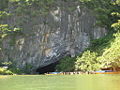
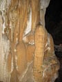
| | ===The Phong Nha cave=== | | ===The Phong Nha cave=== |
| − | This cave from which the name to the whole system and the park is derived is famous for its rock formations which have been given names such as the "Lion", the "Fairy Caves", the "Royal Court", and the "[[Buddharupa|Buddha]]". This cave is 7729 m long, contains 14 grottos, with a 13,969 m-long underground river. The scientists have surveyed 44.5 km of grottos in this cave so far, but tourists can only penetrate to a distance of 1500 m.<ref name="unep-wcmc"/> Phong Nha Caves, like most of the caves in this area, has been continuously shaped by the Chay River. As one gets farther into the cave, the more illusory the stalactites and stalagmites look as they glitter when bright light is shone on them. The Son River flows into the mouth of the cave and keeps flowing underground, where it is referred to as the Nam Aki River, then this river emerges at a site 20 km to the south near Pu Pha Dam Mountain. The main Phong Nha cave includes 14 chambers, connected by an underwater river that runs for 1.5km. Secondary corridors branch off in all directions. The Outer Cave and some of the Inner Caves have roofs that tower between 25 and 40 meters above the water level. From the 14th chamber there may be other corridors leading to similarly large chambers, but this area proves more dangerous for explorers because of the ongoing erosion of the limestone of the cavern. The Shallow cave is located 800 meters from the cave mouth, where there is a spectacular landscape of sand and rock. Stalactites and stalagmites jut out like strange trees, exciting visitor’s imaginations.<ref name="traveltovietnam">{{cite web|url=http://www.wil-travel.com/vn/dlphongnha.php|title=Phong Nha Cave|publisher=Traveltovietnam|date=|accessdate=2008-02-28}}</ref> Notable caves and grottos:
| + | The Phong Nha cave inspired the name for the Park. Famous rock formations have been given names such as the "Lion," the "Fairy Caves," the "Royal Court," and the "[[Buddharupa|Buddha]]." The cave measures 7729 meters long, contains fourteen grottoes, with a 13,969 meter long underground river. Scientists have surveyed 44.5 kilometers of grottoes in the cave so far, but visitors may explore only a distance of 1500 meters.<ref name="unep-wcmc"/> The main Phong Nha cave includes fourteen chambers, connected by an underwater river that runs for 1.5 kilometers. Secondary corridors branch off in several directions. The Outer Cave and some of the Inner Caves have roofs that tower between twenty five and forty meters above the water level. Notable caves and grottoes include Phong Nha Cave system, Vom Cave systems, the Tien Son Cave, and Thien Duong Cave. |
| − | Phong Nha Cave system: | |
| − | *Dark Grotto (''Hang Tối''): located upstream of Son River running to the branch of Chay River on the left. This cave is 5,258 m long and with a height of 83 m. The entry is high and wide with heavy forest around the cave mouth.
| |
| − | | |
| − | *E Grotto (''Hang E''): a 736 m-long grotto accessible by [[Ho Chi Minh trail|Ho Chi Minh Trail]].
| |
| − | *Cha An Grotto (''Hang Chà An''): a 667 m-long grotto, with the width of 15 m.
| |
| − | *Thung Grotto (''Hang Thung''): This grotto has an underground river of 3351 m, with the height in some part exeed 133 . This river receives water resources from Rao Thuong.
| |
| − | *En Grotto (''Hang Én''): a 1645 m long, 78.6 m high grotto. The grotto is wide, there is fine sand field inside. This grotto is the habitat of thousands of sparrows.
| |
| − | *Khe Tien Grotto (''Hang Khe Tiên''): located south of Phong Nha, this grotto is 520 m long.
| |
| − | *Khe Ry Grotto (''Hang Khe Ry''): located south of Phong Nha. The grotto is where the stream Khe Ry (a 13.817 km or 8.585 mi long stream at the elevation of 120 m, originating from a mount 1300 m high) runs out.
| |
| − | *Khe Thi Grotto (''Hang Khe Thi''): The Khe Thi stream originating from the mount and runs underground at this grotto.
| |
| − | | |
| − | ===Vom Cave systems===
| |
| − | *Vom Grotto (''Hang Vòm''): a 15.05 km long, 145 m high grotto with several underground rivers, pools. This grotto features several spectacular stalagmite and stalactites.
| |
| − | *Dai Cao Grotto (''Hang Đai Cao''): this grotto is a connection of Vom Grotto. This grotto is 1645 m long, 28 m high..
| |
| − | *Duot Grotto (''Hang Duột''): This is a connection of Dai Cao Grotto with the length of 3.927 km and height of 45 m. There are some fine sand fields inside.
| |
| − | *Ca Grotto (''Hang Cá''): a 1,500 m long, 62 m high grotto.
| |
| − | *Ho Grotto (''Hang Hổ''): A connection of Ca Grotto with the length of 1,616 m and the height of 46 m
| |
| − | *Over Grotto (''Hang Over''): a 3,244 m long, 103 m high grotto, with the width from 30–50 m.
| |
| − | *Pygmy Grotto (''Hang Pygmy''): This 845 m long grotto has several streams falling from mounts.
| |
| − | *Ruc Caroong Grotto (''Hang Rục Caroòng''): This the habitat of Arem ethnic group. They live in the caves, grottos and on hunting, harvesting natural products.<ref name="cpv">{{cite web|url=http://www.cpv.org.vn/details.asp?topic=32&subtopic=226&id=BT460561268|title=Vườn quốc gia Phong Nha - Kẻ Bàng|publisher=[[Nhan Dan]]|date=2005-11-01|accessdate=2008-02-28}}</ref>
| |
| − | | |
| − | ===Tien Son Cave===
| |
| − | Tien Son cave is another beautiful cave in Phong Nha-Ke Bang area. Tien Son cave was discovered by a local inhabitant by accident in 1935.<ref name="dattroivietnam"> Đất trời Việt Nam by Thái Văn Kiểm</ref> It is located in Son Trach Commune, [[Bo Trach District]]. The entry mouth of Tien Son is 1 km from Phong Nha cave, at an altutude of 200 m. This cave is 980 m in length. A 10 m deep hole is situated 400 m from the entry mouth, then a 500 m long underground cave, dangerous for tourists and therefore is open to professional expeditionists only. Like Phong Nha cave, this cave features spectacular stalactites and stalagmites shaped like several fairy-tales. Stalactite and stalagmite columns and walls here create strange sounds like that of gong and drum if they are knocked with the hand. According to British cave scientists, Tien Son cave was created tens of million years ago when a water current holed this limestone mount in Ke Bang. Following a series of landforms and movement of rocks, this mass was levered or lowered, blocking the current and creating what is now Tien Son cave while the underground river redirected its current to Phong Nha cave. Although Phong Nha and Tien Son caves are located next to each other, there are no linking grottos between them.<ref>{{cite web|url=http://bauchon.tuoitre.com.vn/Tianyon/Index.aspx?ArticleID=241910&ChannelID=458|title=Kỳ vĩ động Tiên Sơn|publisher=[[Tuoi Tre]]|date=2008-02-07|accessdate=2008-02-28}}</ref>
| |
| − | ===Thien Duong Cave===
| |
| − | Thien Duong ('''Paradise''') Cave is a newly found cave in this area. It is regarded by British cave scientists as the largest and longest cave in Phong Nha-Ke Bang, with the most beautiful and spectacular [[stalactites]] and [[stalagmites]] in the park. Nevertheless, tourists are only able to visit some hundred meters and a comprehensive survey has not been conducted yet due to the danger it may create in the farther side and therefore knowledge of this cave is limited and it remains a mystery to the scientists.<ref name="tuoitre27-2-08">{{cite web|url=http://www.tuoitre.com.vn/Tianyon/Index.aspx?ArticleID=244774&ChannelID=481|title=Động Thiên Đường - “Hoàng cung” trong lòng đất (Paradise Cave – an “underground royal palace”|publisher=[[Tuoi Tre]]|date=2008-02-27|accessdate=2008-02-28}}</ref>
| |
| | | | |
| | ==Biodiversity in the park== | | ==Biodiversity in the park== |
| | ===Florae=== | | ===Florae=== |
| − | [[Image:Phongnhakebang11.jpg|200px|thumb|left|Trees on the limestone mounts, a typical florae in Phong Nha-Ke Bang National Park]] | + | [[Image:Phongnhakebang11.jpg|400px|thumb|right|Trees on the limestone mounts, a typical florae in Phong Nha-Ke Bang National Park]] |
| − | The park is part of the [[Annamite Range|Annamites]] eco-region. By far the largest vegetation type is tropical dense moist evergreen forest on limestone under 800 m above sea level. 96.2% of this national park is covered with forest, 92.2% of which is intact primary forest. 74.7% (110,476 ha) of the park is covered with evergreen tropical wet forest on limestone rocks at the elevation of under 800 m; 8.5% (12,600 ha) is evergreen tropical wet forest on limestone rocks at the elevation of above 800 m; 8.3% (12,220 ha) evergreen tropical wet forest on soil mounts at the elevation of under 800 m; evergreen tropical wet forest on limestone rocks at the elevation of under 800 m; 0.7% (1,070 ha) evergreen tropical wet forest on limestone rocks at the elevation of above 800; 1.1% impacted evergreen tropical wet forest on limestone rocks; 2.8% (4,212 ha) impacted evergreen tropical wet forest on soil mounts; 1.3% (1,925) grass, bush on limestone rocks; 2% (2,950 ha) grass, bush on soil mounts; permanent wetland forest: 180 ha; rattan and bamboo forest: 150 ha; and agricultural plants: 521 ha or 0.3%.<ref name="dgmv"/><ref name="eoearth">[http://www.eoearth.org/article/Phong_Nha-Ke_Bang_National_Park,_Vietnam The Encyclopedia Earth]</ref> According to the results of initial surveys, the primary tropical forest in Phong Nha - Ke Bang 140 families, 427 genera, and 751 species of vascular plants, of which 36 species are endangered and listed in the [[Vietnam's Red Data Book]]. | + | The park belongs to the [[Annamite Range|Annamites]] eco-region. Tropical dense moist evergreen forest on limestone under 800 meters above sea level comprises by far the largest vegetation type. Forest cover 96.2 percent of the national park, 92.2 percent constituting intact primary forest. According to the results of initial surveys, the primary tropical forest in Phong Nha-Ke Bang 140 families, 427 genera, and 751 species of vascular plants, including thirty six endangered species. |
| | | | |
| − | The most commont tree species in this park are ''[[Hopea sp.]]'', ''[[Sumbaviopsis albicans]]'', ''[[Garcinia fragraeoides]]'', ''[[Burretionendron hsienmu]]'', ''[[Chukrasia tabularis]]'', ''[[Photinia aroboreum]]'' and ''[[Dysospyros saletti]]''. Seedlings can only grow in holes and cracks in the limestone where soil has accumulated, so in general regeneration after disturbance is slow.
| + | ''[[Hopea sp.]],'' ''[[Sumbaviopsis albicans]],'' ''[[Garcinia fragraeoides]],'' ''[[Burretionendron hsienmu]],'' ''[[Chukrasia tabularis]],'' ''[[Photinia aroboreum]],'' and ''[[Dysospyros saletti]]'' constitute the most common tree species in the park. Seedlings can only grow in holes and cracks in the limestone where soil has accumulated, so in general regeneration after disturbance proceeds slowly. [[evergreen]] tree species with scattered deciduous trees such as ''[[Dipterocarpus kerri]],'' ''[[Anogeissus acuminate]],'' ''[[Pometia pinnata]],'' and ''[[Lagerstroemia calyculata]]'' dominate the forest. |
| | | | |
| − | The forest type in this national park is dominated by [[evergreen]] tree species with scattered deciduous trees such as ''[[Dipterocarpus kerri]]'', ''[[Anogeissus acuminate]]'', ''[[Pometia pinnata]]'' and ''[[Lagerstroemia calyculata]]''. | + | The dominant plant families include the [[Lauraceae]], [[Fagacaeae]], [[Theaceae]] and [[Rosaceae]], with some scattered [[gymnosperm]]s such as ''[[Podocarpus imbricatus]],'' ''[[Podocarpus neriifolius]],'' and ''[[Nageia fleuryi]]''. A 5000-ha forest of ''Calocedrus macrolepis'' on limestone ''(Calocedrus rupestris)'' mounts with about 2,500 trees, 600 per hectare exists, constituting the largest forest with this tree in Vietnam. Most of the trees have been dated at 500 to 600 years old. |
| | | | |
| − | In this park, the dominant plant families are the [[Lauraceae]], [[Fagacaeae]], [[Theaceae]] and [[Rosaceae]], with some scattered [[gymnosperm]]s such as ''[[Podocarpus imbricatus]]'', ''[[Podocarpus neriifolius]]'', and ''[[Nageia fleuryi]]''.<ref name="eoearth">[http://www.eoearth.org/article/Phong_Nha-Ke_Bang_National_Park,_Vietnam The Encyclopedia Earth]</ref><ref name="cpv">[http://www.cpv.org.vn/details.asp?topic=32&subtopic=226&id=BT460561268 Official website of Communist Party of Vietnam]</ref>
| + | ===Fauna=== |
| | + | [[Image:Pseudoryx nghetinhensis.PNG|thumbnail|right|400px| [[Saola]], a species found in Phong Nha-Ke Bang National Park]] |
| | + | [[Image:Tac ke phong nha.jpg|right|thumb|400px|[[Cyrtodactylus phongnhakebangensis]], a newly found species in Phong Nha-Ke Bang National Park]] |
| | | | |
| − | In this national park, there exists a 5000-ha forest of ''Calocedrus macrolepis'' on limestone (''Calocedrus rupestris'') mounts with about 2,500 trees, 600 per hectare. This is the largest forest with this tree in Vietnam. Most of the trees here are 500-600 years old. These trees are listed in group 2A (rare, precious and limited exploitation) of the official letter 3399/VPCP-NN dated 21 June 2002, an amendment to the Decree 48 by the Government of Vietnam.<ref name="Thanh Niên">{{Cite web|url=http://web.thanhnien.com.vn/Khoahoc/2005/9/6/121442.tno|title=Những phát hiện chấn động về Phong Nha - Kẻ Bàng|work=[[Thanh Niên]]|date=[[June 6]], [[2005]]|accessdate=2008-02-05}}</ref>
| + | The forest serves as home to ninety eight families, 256 genera and 381 species of vertebrates. Sixty-six animal species have been listed in Vietnam's Red Data Book and twenty three other species in the World [[IUCN Red List|Red Book of Endangered Species]]. In 2005, a group of Vietnamese biologists, together with biologists working for the park, [[Cologne Zoological Garden|Cologne Zoo]] in Germany and the Saint Petersburg Wild Zoology Institute in Russia discovered a new species of [[gecko]] ''([[Lygosoma boehmeiwas]])''.<ref>[https://reptile-database.reptarium.cz/species?genus=Lygosoma&species=boehmei Lygosoma boehmei] ''Reptile Database''. Retrieved September 18, 2023.</ref> |
| | | | |
| − | [[Natural University, Hanoi National University]], in combination with the Research Center of Phong Nha-Ke Bang National Park, has discovered 1,320 additional species in this park, of which some groups are assessed as specially rare and precious.<ref name="Thanh Niên"/> | + | The [[Gaur]], and one specie of eel, have been discovered in the park.<ref name="unep-wcmc"/> The Park hosts significant populations of [[primate]]s, with ten species and sub-species. Those include the globally vulnerable [[Pig-tailed Macaque]], [[Assam Macaque|Assamese Macaque]], [[Stump-tailed Macaque]], and [[White-cheeked Crested Gibbon]] (''Nomascus leucogenys'' and ''[[Nomascus leucogenys siki]]''). The Park hosts the largest population of [[Francois' Langur]] in Vietnam, including two different forms of the specie. A population of [[Hatinh Langur]] and [[Black Langur]], the largest population of those species in the world and the only population represented in a protected area, inhabit the park. |
| | | | |
| − | Biologists have discovered three rare orchid species.<ref name="thiennhien">http://www.thiennhien.net/news/153/ARTICLE/2243/2007-06-16.html</ref> Orchids found here include: ''[[Paphiopedilum malipoense]]'', ''[[Paphiopedilum dianthum]]'', ''[[Paphiopedilum concolor]]''. In 1996 [[IUCN]] classified these orchid species in danger of extinction in the near future.<ref name="Thanh Niên">{{Cite web|url=http://web.thanhnien.com.vn/Khoahoc/2005/9/6/121442.tno|title=Những phát hiện chấn động về Phong Nha - Kẻ Bàng|work=[[Thanh Niên]]|date=[[6 September]], [[2005]]|accessdate=2008-02-05}}</ref>
| + | Other endangered large mammals include the [[Mainland Serow]] ''(Capricornis sumatraensis)'', [[Giant Muntjac]] ''(Megamuntiacus vuquangensis)'', and the [[Saola]] ''(Pseudoryx nghetinhensis)''. The [[Asiatic Black Bear]] ''(Selenarctos thibetanus)'' and [[Sun Bear]] ''(Helarctos malayanus)'' live in the park. Other smaller mammals include [[Sunda Pangolin]]s ''(Manis javanica)'' and the recently discovered [[Striped hare]], called locally 'tho van' ''([[Nesolagus timminsii]])''. Ten bat species listed in the IUCN List of Threatened Species have been recorded in the park. |
| | | | |
| − | Endemic species in this national park is composed of: ''[[Burretiodendron hsienmu]]'', ''[[Cryptocarya lenticellata]]'',''[[Deutrizanthus tonkinensis]]'', ''[[Eberhardtia tonkinensis]]'', ''[[Heritiera macrophylla]]'', ''[[Hopea sp.]]'', ''[[Illicium parviflorum]]'', ''[[Litsea baviensis]]'', ''[[Madhuca pasquieri]]'', ''[[Michelia faveolata]]'', ''[[Pelthophorum tonkinensis]]'', ''[[Semecarpus annamensis]]'', ''[[Sindora tonkinensis]]''.<ref name="dgmv"/>
| + | Of the fifty nine recorded [[reptile]] and [[amphibian]] species, the [[Vietnam's Red Data Book]] lists eighteen while the [[IUCN Red List|IUCN Red List of Threatened Animals]] lists six. The seventy two fish species include four species endemic to the area, including ''[[Devario quangbinhensis|Chela quangbinhensis]]''.<ref name="unep-wcmc"/> The park offers refuge to over 200 bird species, inclusive of several rare birds such as: [[Chestnut-necklaced Partridge]], [[Red-collared Woodpecker]], [[Brown Hornbill]], [[Sooty Babbler]] and [[Short-tailed Scimitar-babbler]]. The [[Vietnamese Pheasant]] ''(Lophura hatinhensis)'' and [[Imperial Pheasant]] ''(Lophura imperialis)'' species have been spotted in Phong Nha-Kẻ Bàng area.<ref name="dgmv"/> |
| | | | |
| − | ===Faunae===
| + | In an initial survey, Russian and Vietnamese scientists from [[Vietnam-Russia Tropical Centre]] (funded by [[World Wide Fund for Nature|WWF]]) recorded 259 butterfly species in eleven families. Almost all major butterfly taxa in Vietnam have been sighted in Phong Nha-Ke Bang National Park.<ref name="dgmv"/> |
| − | [[Image:Pseudoryx nghetinhensis.PNG|thumbnail|left|200px| [[Saola]], a species found in Phong Nha-Ke Bang National Park]]
| |
| − | [[Image:Tac ke phong nha.jpg|right|thumb|200px|[[Cyrtodactylus phongnhakebangensis]], a newly found species in Phong Nha-Ke Bang National Park]] | |
| | | | |
| − | The forest is also home to 98 families, 256 genera and 381 species of vertebrates. Sixty-six animal species are listed in the [[Vietnam's Red Data Book]] and 23 other species in the World [[IUCN Red List|Red Book of Endangered Species]].
| + | ==Human History== |
| | + | [[Neolithic]] axe heads and similar artifacts found in some of the caves give evidence of the first human habitation in the area. An ancient hieroglyphic script of the [[Cham people|Cham]] ethnic minority had been found in Phong Nha-Ke Bang .<ref name="unep-wcmc"/> In 1995, the [[Archeological Institute of Vietnam]] noted Phong Nha cave as an extremely important archeological site, suggesting that the Bi Ky grotto may have sheltered a Champa mosque from the ninth to eleventh century. Inside Phong Nha cave, many Champa style ceramics with lotus-shaped ruby-colored, and slight pink mouth earthenware vases have been found. |
| | | | |
| − | In 2005, a new species of [[gecko]] (''[[Lygosoma boehmeiwas]]'') was discovered here by a group of Vietnamese biologists together with biologists working for the park, [[Cologne Zoological Garden|Cologne Zoo]] in Germany and the Saint Petersburg Wild Zoology Institute in Russia.<ref name="reptiles.swelluk">{{cite web| title=New Lizards Species Found|url=http://www.reptiles.swelluk.com/reptile-news/new-lizard-species-september2007.html |publisher=reptiles.swelluk|date=2007-09| accessdate=2008-02-22}}</ref> | + | In early twentieth century, cave explorers and researchers from [[France]] and the [[UK]] discovered several ancient Champa and Vietnamese relics, such as altars, steles, hieroglyphic script, sculptures, stone statues, Buddha statues, and Chinese artifacts. King [[Hàm Nghi|Ham Nghi]] built a base for the Vietnamese resistance against the French colonialism during the late nineteenth century.<ref name="unep-wcmc"/> During the [[Vietnam War]], the caves served as an impregnable major base of the North Vietnamese Army. |
| − | | |
| − | The [[Gaur]] and one species of eel have been discovered in this park.<ref name="unep-wcmc"/> Ten new species never seen before in Vietnam were discovered by scientists in this national park.<ref name="practicalfishkeeping">{{cite web| title=New species found in Vietnam|url=http://www.practicalfishkeeping.co.uk/pfk/pages/item.php?news=199|publisher=practicalfishkeeping|date=2004-02-19| accessdate=2008-02-22}}</ref>
| |
| − | | |
| − | The Park is home to significant populations of [[primate]]s in Vietnam, with ten species and sub-species. These include the globally vulnerable [[Pig-tailed Macaque]], [[Assam Macaque|Assamese Macaque]], [[Stump-tailed Macaque]] and [[White-cheeked Crested Gibbon]] (''Nomascus leucogenys'' and ''[[Nomascus leucogenys siki]]''). The Park is probably home to the largest population of [[Francois' Langur]] in Vietnam, including two different forms of the species. The area is highly significant for its population of [[Hatinh Langur]] and [[Black Langur]]. It is undoubtedly the largest population of these species in the world, and probably the only population represented in a protected area. Other endangered large mammals include the [[Mainland Serow]] (''Capricornis sumatraensis''), [[Giant Muntjac]] (''Megamuntiacus vuquangensis'') and possibly the [[Saola]] (''Pseudoryx nghetinhensis''). The [[Asiatic Black Bear]] (''Selenarctos thibetanus'') and [[Sun Bear]] (''Helarctos malayanus'') are confirmed. Other smaller mammals include [[Sunda Pangolin]]s (''Manis javanica'') and the recently discovered [[Striped hare]], called locally 'tho van' (''[[Nesolagus timminsii]]''). Ten bat species listed in the IUCN List of Threatened Species have been recorded in this park.
| |
| − | | |
| − | Of the 59 recorded [[reptile]] and [[amphibian]] species, 18 are listed in [[Vietnam's Red Data Book]] and 6 are listed in the [[IUCN Red List|IUCN Red List of Threatened Animals]]. The 72 fish species include 4 species endemic to the area, including ''[[Devario quangbinhensis|Chela quangbinhensis]]''.<ref name="unep-wcmc"/><ref name="dgmv"/>
| |
| − |
| |
| − | The park is home to over 200 bird species, inclusive of several rare birds such as: [[Chestnut-necklaced Partridge]], [[Red-collared Woodpecker]], [[Brown Hornbill]], [[Sooty Babbler]] and [[Short-tailed Scimitar-babbler]].<ref name="birdlifeindochina">[http://birdlifeindochina.org/birdwatch/phongnhakebang.html Bird Life Indochina, Birding Center in Vietnam]</ref><ref name=cpv">[http://www.cpv.org.vn/details.asp?topic=32&subtopic=226&id=BT460561268 Official website of Communist Party of Vietnam]</ref> There is good evidence for the [[Vietnamese Pheasant]] (''Lophura hatinhensis'') and [[Imperial Pheasant]] (''Lophura imperialis'') species at Phong Nha - Kẻ Bàng area.<ref name="dgmv"/>
| |
| − | | |
| − | An initiative survey conducted by Russian and Vietnamese scientists from [[Vietnam-Russia Tropical Centre]] (funded by [[World Wide Fund for Nature|WWF]]) recorded 259 butterfly species of 11 families. Almost all major butterfly taxa in Vietnam can be found in Phong Nha - Ke Bang National Park.<ref name="dgmv"/>
| |
| − | | |
| − | ==Historical significance==
| |
| − | The oldest evidence of human occupation of the area are [[Neolithic]] axe heads and similar artifacts found in some of the caves. Phong Nha - Ke Bang is home to archeological and historical relics, such as an ancient hieroglyphic script of the [[Cham people|Cham]] ethnic minority.<ref name="unep-wcmc"/> In 1995, the [[Archeological Institute of Vietnam]] remarked that Phong Nha cave is probably an extremely important archeological site. This organization suggested that what remained in Bi Ky grotto may have been a Champa mosque from the 9th to 11th century. Inside Phong Nha cave, many Champa style ceramics, earthware vases with lotus-shaped ruby-colored, slight pink mouth.<ref name="bauchon458">http://bauchon.tuoitre.com.vn/Tianyon/Index.aspx?ArticleID=241634&ChannelID=458 "Cái nôi" văn hóa và lịch sử Phong Nha - Kẻ Bàng]</ref>
| |
| − | | |
| − | In 1899, a French missioner, Léopold Cadière surveyed the customs and culture of the local inhabitants living along the Son River. In the letter to [[École française d'Extrême-Orient]], he stated that: “What remains here proves to be valuable for history. To keep it is to help science”. In early 20th century, cave explorers and researchers from France and the UK discovered several ancient Champa and Vietnamese relics, such as altar, steles, hieroglyphic script, sculptures, stone statues, Buddha statues, and Chinese artifacts.
| |
| − | | |
| − | King [[Hàm Nghi|Ham Nghi]] built a base for the Vietnamese resistance against the French [[Colonialism|colonialist]]s in the late 19th century.<ref name="unep-wcmc"/> | |
| − | | |
| − | During the [[Vietnam War]], the caves were an impregnable major base of the North Vietnamese Army, comprising; Xuan Son Ferry, [[Ho Chi Minh trail|Ho Chi Minh Trail]], Road 20, Mụ Giạ, A.T.P, Trà Ang, Cà Tang, a curve road, Ve stream, Six Sisters grotto, Nine Story grotto, Nguyen Van Troi Ferry, storage depots in caves and grottos in [[Tuyen Hoa]], and [[Minh Hoa]].<ref name="bauchon458">[http://bauchon.tuoitre.com.vn/Tianyon/Index.aspx?ArticleID=241634&ChannelID=458 "Cái nôi" văn hóa và lịch sử Phong Nha - Kẻ Bàng]</ref> | |
| − | | |
| − | ==Recognition by UNESCO==
| |
| − | ===Nomination and recognition in 2003===
| |
| − | Phong Nha-Ke Bang National Park was first nominated as a UNESCO World Heritage Site in 1998. Dossiers was first submitted by Vietnamese government to UNESCO for recognition of Phong Nha nature reserve as a world natural heritage under the name “Phong Nha Nature Reserve”. The reason given for the nomination was that this nature reserve satisfied criteria of biodiversity, unique beauty and geodiversity (criteria I and iv).<ref name="birdlifeindochina"/>
| |
| − | | |
| − | In 1999, the [[World Conservation Union]] (IUCN) conducted a field survey in January and February. At the meeting in July 1999, Evaluation Bureau concluded that Phong Nha Nature Reserve would meet with criteria I and IV as a world heritage nominee on the condition that this nature reserve was expanded to include the larger Phong Nha Ke Bang National Park with an associated fully integrated management structure. This bureau stated that the site was part of an extremely complex and ancient karst plateau with high geodiversity which also encompasses Ke Bang and Hin Namno karsts. The reserve is largely covered in tropical forest with a high level of biodiversity and endemic species. Lack of research means that the true significance of the biodiversity and geology of the area cannot be fully assessed. The evaluation bureau concluded that the nominated area on its own is not considered to meet World Heritage criteria. Nevertheless, if this nature reserve was jointly nominated with the Hin Namno karst ecosystem in [[Laos]], the combined site would constitute the largest surviving area of karst forest in South-east Asia and may merit World Heritage status. The Bureau decided to defer the nomination of Phong Nha Nature Reserve.<ref name="uhc.unesco"/>
| |
| − | | |
| − | In 2000, the government of Vietnam submitted a revised nomination with a much larger area. At this time, however, the [[National Assembly (Vietnam)|National Assemby]] and government of Vietnam also announced that it would be constructing the north-south Ho Chi Minh Highway and a link road between the Highway and Route 20 that bisects part of the core area of the Phong Nha Nature Reserve. The news of this road construction raised concern over its impacts on the Phong Nha Nature Reserve, and many international organization like IUCN, Flora and Fauna International called on Vietnamese government to reconsider its plan. They also advised of the negative impact of these road and construction activities on biodiversity. Due to this plan of road construction, the evaluation bureau did not proceed further consideration of nomination from Vietnamese government at that time.
| |
| − | | |
| − | The government of Vietname provided the bureau with additional information in in May 2002, announcing the decision of the [[Prime Minister of Vietnam]] (December, 2001) on the upgrading of the Phong Nha – Ke Bang Nature Reserve to the Phong Nha – Ke Bang National Park with a total area of 85,754 ha; providing information on projects for the conservation and development of the Park and revised maps. This revised nominated site has a much smaller area than the 2000 nomination, though still relatively larger than that of 1998.<ref name="uhc.unesco"/>
| |
| − | | |
| − | It was recognized as a world natural heritage site at the UNESCO's 27th general assembly session being held in Paris [[June 30]]–[[July 5]], [[2003]]. At the session, delegates from over 160 member countries of UNESCO World Heritage Convention agreed to include Phong Nha-Ke Bang park and 30 others worldwide in the list of world heritage sites. Phong Nha-Ke Bang National Park meets with criteria viiii in accordance with UNESCO’s appraisal scale as it displays an impressive amount of evidence of earth’s history and is a site of very great importance for increasing human understanding of the geologic, geomorphic and geo-chronological history of the region.<ref name="unesco"/>
| |
| − | | |
| − | ===Recognition for a second time===
| |
| − | The National Council for Cultural Heritage, an organization under the Ministry of Culture and Information of Vietnam (now the Ministry of Culture, Sports and Tourism) recommended the Vietnamese prime minister that Phong Nha-Ke Bang National Park be submitted to UNESCO second time for recognition as a world natural heritage for biodiversity (in 2003, this park was listed in UNESCO’s world heritage sites for criteria viii “outstanding geological, geomorphical, and geographical values”.
| |
| − |
| |
| − | Vietnamese and international experts believed that if Vietnam timely submits the proposal documents to UNESCO and meet this UNESCO’s criteria, this national park will be recognized for a second time in 2008.
| |
| − |
| |
| − | Since the recognition by UNESO in 2003, the government of Vietnam has continued to compile scientific documentation to seek recognition of the park as a world natural heritage in terms of biodiversity in addition to geographical values. According to World Wildlife Foundation report in 2000, Phong Nha-Ke Bang National Park is one of 200 biodiversity centres of the world and one of the 60 significant sanctuaries of Vietnam. It has a unique forest type in the world: green tropical forest. The park also has 15 other types of forests.
| |
| − |
| |
| − | At the final conference of the National Council for Cultural Heritage held in Vietnam in 2007, scientists attending the meeting highly praised the scientific documentation of Phong Nha-Ke Bang park. Accordingly, the park is second to no other national parks listed in UNESCO’s world heritage sites as far as biodiversity is concerned.<ref>[http://english.vietnamnet.vn/tech/2007/11/754641/ Phong Nha-Ke Bang again proposed for world natural heritage recognition], 17:09' 13/11/2007 (GMT+7) , access date: 19 February 2008</ref>
| |
| − | | |
| − | ==Tourist activities==
| |
| − | [[Image:Phongnhatourism.jpg|200px|thumb|right|Boats for tourist in Phong Nha-Ke Bang National Park]]
| |
| − | | |
| − | The number of tourists has increased dramatically since the park was listed in UNESCO's World Heritage Sites.<ref name="Vietnam News16-9-2004">{{cite web| title=Tourists flock to Phong Nha-Ke Bang bringing alternative to illegal loggers|url=http://www.vnn.vn/kinhte/2004/03/54521/|publisher=Vietnam News|date=2004-09-16| accessdate=2008-02-26}}</ref>
| |
| − | | |
| − | [[Quang Binh Province]] has invested into upgrading the Phong Nha-Ke Bang visitor site to turn it into one of Vietnam's major tourist destinations.
| |
| − | | |
| − | Multiple eco-tourist projects have been licensed for development and the area is being heavily developed by the province to turn it into a major tourist site in Vietnam. Phong Nha Ke Bang is part of a tourism promotion program called: "[[Middle World Heritage Road]]" which includes the ancient capital of [[Huế]], the [[Champa]] relics of [[Mỹ Sơn|My Son]], the city of [[Hội An|Hoi An]], [[Nhã nhạc|nha nhac]] and the [[Space of Gong Culture in the Central Highlands of Vietnam]].<ref name="peacetourco"><ref name="vnn9-3-2004nea">{{cite web| title=Hành trình “Con đường di sản miền Trung”|url=http://www.vnn.vn/kinhte/2004/03/54521/|publisher=Vietnam News|date=2004-03-09| accessdate=2008-02-24}}</ref>
| |
| − | | |
| − | Tourist activities in Phong Nha-Ke Bang National Park are organized by local travel agencies and vary in form:
| |
| − | *Tour for expedition of caves and grottos in boats and with professional cave expedtion means.<ref name="chieuxua">[http://chieuxua.com/forums/viewtopic.php?t=1342 du lịch mạo hiểm Phong Nha-Kẻ Bàng]</ref>
| |
| − | *Ecotourism, discovering the florae and fauna in this national park in the Ke Bang Forest.<ref name="đulichvn">[http://www.dulichvn.org.vn/thongtinquanly/dautudulich/kdl_phongnha-kebang.htm khu du lịch sinh thái Phong Nha-Kẻ Bàng]</ref>
| |
| − | *Mountain climbing: There are extreme sloping mountains here with a height of over 1,000 m, which is a real challenge for adventurous climbers.<ref name="chieuxua" />
| |
| − | | |
| − | One of the adventure tour sites is boating upward on the Chay River into primitive forests, as the river becomes sinuous with several waterfalls and whirlpools until tourists arrive at Tro Mong. This tour sites have been surveyed and included in local travel agents besides cave exploration tour. In Phong Nha-Ke Bang park, there are is a 50 m-high waterfall, Chai Waterfall. There is a bull filed called Ran Bo (Bull Field) due to the fact that wild bulls usually comes and reproduce in mating season. There are also some interesting tourist attractions in this park like Nước Ngang (lit.: Horizontal Spring), a spring runs horizontally instead of vertically as usual; Ðá Nằm (Crouching Stone), a stone blockading a stream current; Chân Thớt (Chopping Board), a chopping-board-shaped stone. But above all, the most spectacular scene is this area is Nước Trồi (Surfacing Stream), a stream surfacing from the ground. Several streams here run for a long distance, then disappear under the ground.<ref name="bauchon15-2-2008">{{cite web| title=Mùa xuân, du lịch rừng Phong Nha|url=http://bauchon.tuoitre.com.vn/Tianyon/Index.aspx?ArticleID=241869&ChannelID=458|publisher=[[báo Tuổi Trẻ]]|date=2008-02-15| accessdate=2008-02-22}}</ref>
| |
| − | | |
| − | Thanks to the tourism development in this national park, about 1000 local residents have jobs in tourism. The provincial Centre for Phong Nha-Ke Bang’s Ecotourism and Culture currently has 248 boats, creating jobs for 500 locals . Every boat has two trained boatmen earning VND70,000 per day. This income is relatively high for peasants in this province. This centre also launched a programme in 2000 to train former loggers to work as photographers taking pictures for tourists and about 300 former loggers are now doing this.<ref name="Vietnam News16-9-2004"/>
| |
| − | | |
| − | In order to facilitate the increasing flow of tourists to the site, the [[Dong Hoi Airport]] was constructed and is due to be operational at the end of 2008.
| |
| − | | |
| − | Phong Nha-Ke Bang, together with [[Halong Bay|Ha Long Bay]] and [[Fansipan|Fanxipan]] of Vietnam, is listed as a candidate for 7 new world natural wonders vote. As of February 12, 2008 it ranked 10th in the voting list<ref name="new7wonders">[http://www.new7wonders.com/nature/en/nominees/asia/c/HongNhaKeBangNationalPark/ new7wonders]</ref>
| |
| | | | |
| | ==Management issues== | | ==Management issues== |
| | ===Management activities=== | | ===Management activities=== |
| − | The Park Management Board includes just 115 people, composed of zoologists, botanists, silviculturalists, and socio-economists. This management staff lacks the authority to fine violators and lacks equipment like helicopters and sufficient funds, thus it's hard to efficiently deal with natural and human threats to the park.<ref name="unep-wcmc">[http://www.unep-wcmc.org/sites/wh/Phong_nha.html United Nations Environment Programme, World Conservation Monitoring Centre]</ref><ref name="unep-wcmc"/><ref name="birdlifeindochina">[http://birdlifeindochina.org/source_book/pdf/Bac%20Trung%20Bo/Phong%20Nha%20-%20ke%20Bang.pdf Microsoft Word - Phong Nha - ke Bang.doc<!-- Bot generated title —>]</ref> | + | The Park Management Board includes 115 people serving as zoologists, botanists, silviculturists, and socio-economists. The management staff lacks the authority to fine violators and lacks equipment like helicopters and sufficient funds, hamstringing their attempts to efficiently deal with natural and human threats to the park.<ref name="unep-wcmc"/> The government has created an eighteen hectare semi-wild zone, surrounded by electrical wire fence, for the primate species. The preserve had been sponsored by [[Zoologische Gesellschaft Frankfurt]] ([[Germany]]) to provide a sanctuary for ten species of primates, including ''[[Trachypithecus francoisi hatinhensis]]'', ''[[red-shanked douc langur]]'' or ''[[Pygathrix nemaeus nemaeus)]]''. |
| − | | |
| − | A 18-hectare semi-wild zone, surrounded by electrical wire fence, saved for the primate species was created in this park. This project is sponsored by [[Zoologische Gesellschaft Frankfurt]] ([[Germany]]) in order to provide a sanctuary for 10 species of primates, including ''[[Trachypithecus francoisi hatinhensis]]'', ''[[red-shanked douc langur]]'' or ''[[Pygathrix nemaeus nemaeus)]]''. This protection zone is suitable for primates habitat.<ref name="thiennhien">http://www.thiennhien.net/news/155/ARTICLE/3731/2007-11-30.html</ref>
| |
| | | | |
| | ===Threats to biodiversity=== | | ===Threats to biodiversity=== |
| − | There are two villages of Arem an Ma Coong ethnic groups in the core zone of the Phong Nha-Ke Bang National Park. Within the buffer zone, there is a population of 52,001. They are mainly Kinh people and other minority groups of Chut and Van Kieu, many of them exploit forest products as part of their livelihoods.
| + | Two villages, Arem and Ma Coong, exist in the core zone of the Phong Nha-Ke Bang National Park. The buffer zone has a population of 52,001, mainly Kinh people and other minority groups of Chut and Van Kieu. Many of the villagers living in the buffer zone exploit the forest for a livelihood. The increase of visitors to the park has increased water pollution & rubbish pollution. Hunting by locals has been a significant threat to the wildlife, especially the wild pig, [[binturong]], rare eels like ''[[Anguilla marmorota]]'' and ''[[Anguilla bicolo]]'', and primates. |
| − | | |
| − | The increase of visitors to this park is also a problem to the park since unexpected pollution (water pollution, rubbish), human impacts on caves and grottos may cause damage to them and especially threaten biodiversity. Hunting is a significant threat to the wildlife because local people have a great consumption demand on wild meat and this has contributed to the significant decrease of species such as the wild pig, [[binturong]] and primates. While local authorities have taken no legal action, nevertheless, some civil servants and policemen are the owners of restaurants that serve wild animal meats hunted in this national park.<ref name="vnn">[http://www.vnn.vn/xahoi/doisong/2005/10/501351/ Thú rừng Phong Nha - Kẻ Bàng ngắc ngoải kêu cứu...trong nồi (wild animals in Phong Nha-Ke Bang forest are dying in cooks)]</ref><ref name="englishvietnamnet24-10-05">{{cite web|url=http://english.vietnamnet.vn/features/2005/10/503609/|title=Phong Nha – Ke Bang: wild animals cry for help|publisher=Vietnamnet|date=2005-10-24|accessdate=2008-02-28}}</ref> Phong Nha-Ke Bang National Park is currently not meaningful for protection of [[tiger]]s, [[Asian Elephant]]s, and wild bulls.<ref name="birdlifeindochina"/> | |
| − | | |
| − | Rare eels like ''[[Anguilla marmorota]]'' and ''[[Anguilla bicolo]]'' have been caught and consumed in large numbers by the local residents and served as specialities in restaurants due to the fact that local inhabitants believe they are "natural [[Sildenafil|Viagra]]".<ref name="tienphong29-12-2006">{{cite web| title=Thượng sơn hỏi chuyện “Đệ nhất cá chình”|url=http://baotienphong.com.vn/Tianyon/Index.aspx?ArticleID=71349&ChannelID=13|publisher=[[Tiền Phong]]|date=2006-12-29| accessdate=2008-02-26}}</ref>
| |
| | | | |
| − | Excessive exploitation of rare wood such as [[Lama tree|Go Mun]] wood (''Diospyros spp.'') and Go Hue wood (''[[Dalbergia rimosa]]'') and oils from trees such as ''[[Cinnamomum balansea]]'', [[rattan]] has cause an exhaustion of these plants in many areas of the park. Bat population in caves and grottos also face disturbance by human activities.
| + | Locals cutting of rare wood such as [[Lama tree|Go Mun]] wood ''(Diospyros spp.)'' and Go Hue wood ''([[Dalbergia rimosa]])'' has harmed the forests. During the construction of roads, blasts and construction work have kept several primates away from their regular habitat.<ref name="wrm">[https://www.wrm.org.uy/bulletin-articles/vietnam-road-building-threatens-phong-nha-nature-reserve Vietnam: Road-building threatens Phong Nha Nature Reserve] ''World Rainforest Movement'', December 13, 2000. Retrieved September 18, 2023.</ref> Limestone in Phong Nha-Ke Bang area has been exploited for commercial purposes by local inhabitants. The provincial government approved a 3600MW coal-fueled thermoelectric plant in Vĩnh Sơn village, Quảng Đông commune, [[Quang Trach]] district, forty kilometers northeast of the national park. The project has many environmentalists deeply concerned. |
| − | | |
| − | [[Ho Chi Minh Highway]], [[Road 20 (Vietnam)|Road 20]] crossing the edge zone and the connection road linking these two roads crossing the core zone also contribute danger to the wildlife in this national park, especially populations of [[Hatinh Langur]] and [[Black Langur]]. During the construction of this road, blasts and other activities kept several primates away from their regular habitat.<ref name="wrm">[http://www.wrm.org.uy/bulletin/41/Vietnam.html Vietnam: Road-building threatens Phong Nha Nature Reserve]</ref><ref name="birdlife">{{cite web| title=BirdLife IBA Factsheet|url=http://www.birdlife.org/datazone/sites/index.html?action=SitHTMDetails.asp&sid=12043&m=0|publisher=BirdLide|date=| accessdate=2008-02-26}}</ref>
| |
| − | | |
| − | Due to poor management by the local government, many areas of forest in the buffer zone were cleared heavily, some completely.<ref name="tienphong16-11-2006">{{cite web| title=Rừng vùng đệm Phong Nha- Kẻ Bàng bị tàn phá|url=http://www.tienphongonline.com.vn/Tianyon/Index.aspx?ArticleID=66883&ChannelID=3|publisher=[[báo Tiền Phong]]|date=2006-11-16| accessdate=2008-02-22}}</ref>
| |
| − | | |
| − | Limestone in Phong Nha-Ke Bang area has been exploited for commercial purposes by local inhabitants, but the local authority has taken no countermeasures to prevent this.<ref>{{cite web| title=Phong Nha - Kẻ Bàng đang bị 'băm nát'|url=http://vnexpress.net/Vietnam/Xa-hoi/2004/08/3B9D54AA/|publisher=vnexpress|date=2004-08-10| accessdate=2008-02-26}}</ref> | |
| − | | |
| − | The provincial government approved a 3600MW coal-fueled thermaleclectrical plant in Vĩnh Sơn village, Quảng Đông commune, [[Quang Trach]] district, 40 km northeast of this national park. This project has deeply concerned many enviromentlists as it will probably cause air and water pollution to the park.<ref>{{cite web| title=Hãy bảo vệ Phong Nha – Kẻ Bàng|url=http://www.quangbinhonline.com/CMS/newsctl.aspx?arId=670&grpid=22&cms_action=0|publisher=quangbinhonline|date=2007-11-12| accessdate=2008-02-26}}</ref> | |
| − | | |
| − | [[Wildfire]] in the dry season is a regular threat to the forest in this national park.<ref name="unep-wcmc"/>
| |
| − | | |
| − | ===Land management in adjacent areas===
| |
| − | | |
| − | The land management and regulation of the commercial activities in the area surrounding the park have been carried out by the provincial authorities in a disorganized manner. Blocks of land have been sold to local investors and inhabitants for building service utilities in a haphazard way, resulting in the formation of a slum at the entrance of the park. This has been compounded by some investors who do not develop their lots but hold them for future sale. The planning scheme for 200 hectares of land adjacent to the park was criticized by many experts as having been done "without future vision".<ref name="cinet">{{cite web| title=Phong Nha – Kẻ Bàng: Ngổn ngang chờ quy hoạch|url=http://didulich.net/Public/viewNews_new.jsp?code=25&chude=4|publisher=[[Ministry of Culture, Sports and Toursim of Vietnam]]|date=2005-12-01| accessdate=2008-02-22}}</ref><ref name="sggp">{{cite web| title=Chuyện lạ ở Phong Nha-Kẻ Bàng|url=http://www.sggp.org.vn/phongsudieutra/2006/11/73726/|publisher=[[Báo Sài Gòn Giải Phóng]]|date=2006-11-28| accessdate=2008-02-22}}</ref> Quang Binh's provincial government responded by declaring their intention to recruit internationally-recognised planners to help draft tourism development plans for the adjacent areas.<ref name="didulich">{{cite web| title=Thuê chuyên gia nước ngoài quy hoạch Phong Nha-Kẻ Bàng|url=http://didulich.net/Public/viewNews_new.jsp?code=25&chude=4|publisher=didulich.net|date=2007-09-07| accessdate=2008-02-22}}</ref>
| |
| | | | |
| | ===International funding=== | | ===International funding=== |
| − | On November 3, 2005, the [[Government of Germany|German government]] announced funding valued at 12.6 million euros for the park's management board for the purpose of protecting the biodiversity of the park.<ref>{{Cite web|url=http://www.hanoi.diplo.de/Vertretung/hanoi/vi/Archiv/Presseerklaerung__10__2005.html|title=Đức giúp Vườn quốc gia Phong Nha – Kẻ Bàng (Germany donates to Phong Nha-Ke Bang National Park)|work=German Embassy in Vietnam|date=2005-11-03|accessdate=2008-02-26}}</ref><ref>{{Cite web|url=http://www.vnagency.com.vn/Home/EN/tabid/119/itemid/233507/Default.aspx|title=Germany helps preserve Phong Nha-Ke Bang park|work=[[Việt Nam News]]|date=[[25 January]], [[2007]]|accessdate=2008-02-14}}</ref>
| + | The [[Government of Germany|German government]] announced on November 3, 2005, funding of 12.6 million euros for the purpose of protecting the biodiversity of the park. They earmarked the funds for the park's management board. In 2007, the German government donated a further 1.8 million euros to Vietnam for protection of the park. And in 2015, the German government approved a project on sustainable conservation and management work, with a total investment of 2.175 million Euro (EUR) (2.324 million USD).<ref> [https://en.vietnamplus.vn/2-mln-eur-in-oda-mobilised-for-phong-nha-ke-bang/85181.vnp 2 mln EUR in ODA mobilised for Phong Nha –Ke Bang] ''Vietnam Plus'' (November 24, 2015). Retrieved September 18, 2023.</ref> |
| − | | |
| − | In 2007, the German government donated a further 1.8 million euros to Vietnam for protection of this park.<ref name="dantri23-10-2005">{{cite web| title=Đức ủng hộ gần 2 triệu euro cho Vườn Quốc gia Phong Nha Kẻ Bàng|url=http://www1.dantri.com.vn/Sukien/2007/1/202552.vip |publisher=dantri|date=2007-10-23| accessdate=2008-02-24}}</ref> | |
| − | | |
| − | [[Fauna & Flora International]] donated USD 132,000 to Phong Nha-Ke Bang National Park Management Board for the protection of primates in this national park as well as in the buffer zone.<ref>{{Cite web|url=http://www.isge.monre.gov.vn/index.php?mod=viewcontent&id_content=609&id_item=23&id_group|title=FFI hỗ trợ bảo tồn loài linh trưởng ở Phong Nha Kẻ Bàng|work=[ISGE|date=|accessdate=2008-02-24}}</ref>
| |
| | | | |
| − | In 1998, FFI conducted a training project for the management staff of the park. The British Commission for International Development sponsored a fund for the [[World Wide Fund for Nature|WWF]] to protect the biodiversity in the park and in the adjacent [[Hin Namno]] Nature Reserve in [[Laos]]. FFI also received environmental funding from the British [[Department for Environment, Food and Rural Affairs]] to implement a campaign targeted at increasing awareness about biodiversity protection among tourists and locals.<ref name="birdlifeindochina"/> | + | [[Fauna & Flora International]] (FFI) donated USD 132,000 to Phong Nha-Ke Bang National Park Management Board for the protection of primates in the park as well as in the buffer zone. In 1998, Fauna & Flora International conducted a training program for the management staff of the park. The British Commission for International Development sponsored a fund for the [[World Wide Fund for Nature|WWF]] to protect the biodiversity in the park and in the adjacent [[Hin Namno]] Nature Reserve in [[Laos]]. The Fauna & Flora International also received environmental funding from the British [[Department for Environment, Food and Rural Affairs]] to implement a campaign targeted at increasing awareness about biodiversity protection among tourists and locals. |
| | | | |
| − | ==References==
| |
| − | {{reflist|2}}
| |
| − |
| |
| − | ==Further reading==
| |
| − | *Anon. (1993). Management plan of Phong Nha Nature Reserve Quang Binh province. Unpublished report to Ministry of Forestry, Hanoi.
| |
| − | *Cao Văn Sung & Le Quy An (eds.). (1998). Environment and Bioresources of Vietnam. Gioi Publishers, Hanoi.
| |
| − | *Eames J. C., Lambert F. R. and Nguyen Cu. (1995). Rediscovery of the Sooty Babbler Stchyris herberti in central Vietnam. Bird Conservation International. 5: 129- 135.
| |
| − | *Le Xuan Canh, Truong Van La, Dang thi Dap, ho Thu Cuc, Ngo Anh Dao, Nguyen Ngoc Chinh, Vu Van Dung, Pham Hnat, Nguyen Tahia Tu, Nguyen Quoc Thang and Tran Minh Hien. (1997). A report of field surveys on Biodiversity in Phong Nha Ke Bang forest (Quang Binh Province, central Vietnam). IEBR / FIPI / Forestry College / University of Vinh / WWF Indochina Programme. Unpublished.
| |
| − | *Nadler, T. (1996-1997). Black langur rediscovered. Asian Primates 6 (3 & 4): 10-12.
| |
| − | *Nguyen Binh. (1961). Brief Introduction of Mountainous Minority People of Quang Binh Province. Ethnology 23, Hanoi.
| |
| − | *Nguyen Quang My and Howard Limbert. (1993). Tropical Karst in Vietnam. Hanoi University.
| |
| − | *Nguyen Quang My & Limbert, Howard. (2002). Ky Quan Hang Dong Vietnam (The Wonders of Vietnamese Caves). Trung Tam Ban Do Va tranh Anh Giao Duc, Hanoi.
| |
| − | *Nguyen Quoc Loc, (1984). The Minority Ethnic Groups of Binh Tri Thien Province. Thuan Hoa Publishing House.
| |
| − | *Nguyen Xuan Dang, Pham Nhat, Pham Trong Anh, Hendrichsen, D. K. (1998). Ket qua dieu tra nghien cuu khu he thu o Phang Nha - Ke Bang (survey results of fauna in Phong Nha-Ke Bang). FFI Indochina Programme/IEBR, Hanoi. In Vietnamese.
| |
| − | *Ovel, C. and Nguyen Thi Dao. (1998). LINC: linking Him Namno and Phong Nha through parallel conservation: phase 1 Phong Nha Ke-Bang Nature Reserve, Vietnam Draft project document. WWF Indochina Programme, Hanoi.
| |
| − | *Pham Khang. (1985). The development of karst landscapes in Vietnam. Acta Geologica Polonica. 35 (3-4). pp 305-319.
| |
| − | *Pham Nhat, Do Tuoc and Truong Van La. (1996-1997). Preliminary Survey for the Hatinh Langur in north-central Vietnam. Asian Primates 6 (3 & 4): 13-17.
| |
| − | *Lippold, L. K. (1993). Distribution and status of the Douc Langurs in Vietnam. Asian Primates 5 (1 & 2): 4-6.
| |
| − | *Meijboom, M. & Ho Thi Ngoc Lanh. (2002). He Dong - Thuc Vat / O Phong Nha - Ke Bang Va Hin Namno. Phong Nha-Ke Bang National Park with WWF, Hanoi.
| |
| − | *Pham Nat, Do Tuoc, Truon Van La. (1995). A survey for Hatinh Langur (Trachypithecus francoisi hatinhensis) in North Central Vietnam. WWF/PCT.
| |
| − | *Timmins, R. J., Do Tuoc, Trinh Viet Cong and D. K. Hendrichson. (1999). Preliminary Assessment of the Conservation Importance and Conservation Priorities of the Phong Nha-Ke Bang Proposed National Park, Quang Binh Province, Vietnam. Fauna and Flora International - Indochina Programme, Hanoi.
| |
| − | *Wikramanayake, E.D. et al. (2002). Terrestrial Ecoregions of the Indo-Pacific: A conservation Assessment. Island Press, New York. ISBN 1559639237
| |
| | ==Gallery== | | ==Gallery== |
| | + | <center> |
| | <gallery> | | <gallery> |
| | Image:Phongnhakebang2.jpg|The mouth of Phong Nha cave with underground river | | Image:Phongnhakebang2.jpg|The mouth of Phong Nha cave with underground river |
| Line 324: |
Line 108: |
| | Image:Phongnhakebang13.jpg|Phong Nha Ke Bang National Park | | Image:Phongnhakebang13.jpg|Phong Nha Ke Bang National Park |
| | </gallery> | | </gallery> |
| | + | </center> |
| | + | |
| | + | ==Notes== |
| | + | <references/> |
| | + | |
| | + | ==References== |
| | + | * Averyanov, Leonid, N.T. Hiep, and P.K. Loc. ''Flora and vegetation of areas allied to Phong Nha – Ke Bang''. LAP LAMBERT Academic Publishing, 2012. ISBN 978-3659217845 |
| | + | * Đại học quó̂c gia Hà Nội. ''Kỳ quan hang động Việt Nam = The wonders of Vietnamese caves''. [Hà Nội]: Trung tâm Bản đò̂ và Tranh ảnh Giáo dục, 2001. {{OCLC|49890530}} |
| | + | * Lambert, F. R., J. C. Eames, and N. Cu. "The habitat, status, vocalizations and breeding biology of Blue-rumped Pitta Pitta soror annamensis in central Vietnam." ''Forktail'' 11 (1996): 151-154. {{OCLC|194944824}} |
| | + | * Nguyẽ̂n, Bính, and Quang Huy. ''Thơ Nguyẽ̂n Bính''. Hà Nội: Văn hóa - thông tin, 1993. {{OCLC|64087230}} |
| | + | * Timmins, R.J. A preliminary assessment of the conservation importance and conservation priorities of the Phong Nha-Ke Bang proposed national park, Quang Binh province, Vietnam = Đánh giá sơ bộ về ý nghĩa và những ưu tiên bảo tồn dề xuất Vuờn Quốc gia Phong Nha-Kẻ Bàng, tỉnh Quảng Bình, Việt Nam. Hanoi: Fauna & Flora International—Indochina Programme, 1999. {{OCLC|43973196}} |
| | | | |
| | == External links == | | == External links == |
| − | {{coor title dm|17|32|N|106|9|E}}
| + | All links retrieved September 18, 2023. |
| − | {{commonscat|Phong Nha-Ke Bang National Park}}
| + | |
| − | *[http://whc.unesco.org/pg.cfm?cid=31&id_site=951 UNESCO World Heritage page for Phong Nha-Ke Bang] | + | * [https://whc.unesco.org/pg.cfm?cid=31&id_site=951 Phong Nha-Ke Bang National Park] ''UNESCO World Heritage Convention'' |
| − | *[http://www.terragalleria.com/vietnam/vietnam.phong-nha.html See pictures of Phong Nha Ke Bang] | + | * https://www.terragalleria.com/vietnam/vietnam.phong-nha.html Pictures of Phong Nha Ke Bang]. |
| − | *[http://www.thanhniennews.com/print.php?catid=7&newsid=11134 Phong Nha-Ke Bang on Thanhniennews in English]
| + | * [https://vietnam.travel/things-to-do/complete-guide-phong-nha A Complete Guide to Phong Nha] ''Official Website Vietnam Tourism'' |
| − | *[http://english.vietnamnet.vn/travel/2008/03/773384/ "Amazing natural beauty of Phong Nha-Ke Bang", Vietnamnet News] | + | |
| | {{World Heritage Sites in Vietnam}} | | {{World Heritage Sites in Vietnam}} |
| | {{National parks of Vietnam}} | | {{National parks of Vietnam}} |
| | | | |
| − | [[Category:World Heritage Sites in Vietnam]] | + | [[Category:World Heritage Sites]] |
| − | [[Category:National parks of Vietnam]] | + | [[Category:Geography]] |
| − | [[Category:Association of Southeast Asian Nations heritage parks]]
| |
| − | [[Category:Quang Binh Province]]
| |
| − | [[Category:Caves of Vietnam]]
| |
| − | | |
| − | {{Link FA|vi}}
| |
| − | [[bn:ফং না-কে বাং]]
| |
| − | [[bs:Nacionalni park Phong Nha Ke Bang]]
| |
| − | [[br:Phong Nha-Ke Bang]]
| |
| − | [[ca:Phong Nha – Kẻ Bàng]]
| |
| − | [[ceb:Phong Nha-Ke Bang]]
| |
| − | [[cs:Phong Nha-Ke Bang]]
| |
| − | [[da:Phong Nha-Ke Bang]]
| |
| − | [[de:Phong Nha-Ke Bang]]
| |
| − | [[et:Phong Nha-Kẻ Bàngi rahvuspark]]
| |
| − | [[el:Εθνικό Πάρκο Phong Nha-Ke Bang]]
| |
| − | [[es:Parque Nacional Phong Nha-Ke Bang]]
| |
| − | [[eo:Phong Nha-Ke Bang]]
| |
| − | [[fr:Parc national de Phong Nha - Ke Bang]]
| |
| − | [[gl:Parque Nacional de Phong Nha-Ke Bang]]
| |
| − | [[hi:Phong Nha-Ke Bang]]
| |
| − | [[hr:Nacionalni park Phong Nha Ke Bang]]
| |
| − | [[id:Phong Nha-Ke Bang]]
| |
| − | [[it:Phong Nha-Ke Bang]]
| |
| − | [[he:הפארק הלאומי פהונג נהא-קה באנג]]
| |
| − | [[pam:Phong Nha-Ke Bang]]
| |
| − | [[lo:ອຸດທະຍານແຫ່ງຊາດຟົງ ງາ-ເຄ ບັງ]]
| |
| − | [[la:Phong Nha-Ke Bang]]
| |
| − | [[lv:Fonņas-Kebana nacionālais parks]]
| |
| − | [[lb:Phong Nha-Ke Bang]]
| |
| − | [[lt:Phongnakebango nacionalinis parkas]]
| |
| − | [[lmo:Phong Nha-Ke Bang]]
| |
| − | [[hu:Phong Nha – Ke Bang Nemzeti Park]]
| |
| − | [[ms:Phong Nha-Ke Bang]]
| |
| − | [[nl:Phong Nha-Ke Bang]]
| |
| − | [[new:Phong Nha-Ke Bang]]
| |
| − | [[ja:フォンニャ=ケバン国立公園]]
| |
| − | [[no:Phong Nha-Ke Bang, nasjonalpark]]
| |
| − | [[nn:Phong Nha-Ke Bang]]
| |
| − | [[pl:Park Narodowy Phong Nha-Ke Bang]]
| |
| − | [[pt:Phong Nha-Ke Bang]]
| |
| − | [[ru:Пхонг-Нха-Ке-Банг]]
| |
| − | [[simple:Phong Nha-Ke Bang National Park]]
| |
| − | [[sk:Národný park Phong Nha-Ke Bang]]
| |
| − | [[sl:Phong Nha-Ke Bang]]
| |
| − | [[fi:Phong Nha-Ke Bangin kansallispuisto]]
| |
| − | [[sv:Phong Nha-Ke Bang nationalpark]]
| |
| − | [[tl:Phong Nha-Ke Bang]]
| |
| − | [[th:อุทยานแห่งชาติฟง งา-เค บัง]]
| |
| − | [[vi:Vườn quốc gia Phong Nha-Kẻ Bàng]]
| |
| − | [[uk:Хонг-Нха-Ке-Бан]]
| |
| − | [[vo:Fong Nya-Ke Bang]]
| |
| − | [[zh-yue:風牙者榜國家公園]]
| |
| − | [[zh:風牙者榜國家公園]]
| |
| | | | |
| | {{credits|225918955}} | | {{credits|225918955}} |
Phong Nha-Ke Bang (Vietnamese: Vườn quốc gia Phong Nha-Kẻ Bàng) is one of the world's largest karst regions with 300 caves and grottoes. They extend about 70 kilometers (43 mi) with the world's longest underground river, as well as the largest caverns and passageways ever discovered. The government of Vietnam declared Phong Nha-Ke Bang a national park in 2001 to protect the cave and grotto system as well as the ecosystem of the limestone forest there. Some of the evergreen trees are dated at 500 to 600 years old. Among the hundreds of types of flora, thirty six endangered species thrive. Fauna abounds throughout the park as well, including twenty three endangered species and sixty six receiving special protection from the Vietnamese government.
The region is also important as an archeological site. Neolithic artifacts have been found from Vietnam's prehistoric period as well as excellent samples of hieroglyphic script of the Cham tribe. It is thought by some archeologists that the Bi Ky grotto may have housed a Champa mosque during the ninth through eleventh centuries. Champa inscriptions from early Vietnamese history have been carved on steles and altars. Champa-style ceramics as well have been discovered there. UNESCO declared Phong Nha-Ke Bang a World Heritage Site in 2003.[1]
Location
Phong Nha-Ke Bang is located in the Bố Trạch and Minh Hóa districts of central Quang Binh Province, in north-central Vietnam, about 500 kilometers south of the nation's capital, Hanoi. The park borders the Hin Namno Nature Reserve in the province of Khammouan, Laos by the west, forty two kilometers east of South China Sea. Phong Nha-Ke Bang National Park is located in a limestone zone of 200,000 hectare in Vietnamese territory and borders another limestone zone of 200,000 hectares of Hin Namno in Laotian territory. The core zone of the national park covers 85,754 hectares and the total property comprises an area of 123,326 ha.[1]
Exploration
Champa inscriptions carved on steles and altars in the cave give evidence that people had inhabited the cave long before Vietnam annexed the area in the Nam Tien southward expansion. In 1550, Dương Văn An became the first Vietnamese man to write about Phong Nha cave. Phong Nha cave has been depicted in nine urns in the Citadel of the Nguyen Dynasty in Huế.[2] In 1824, king Minh Mang conferred the title "Diệu ứng chi thần" (Han Tu: 妙應之神) on Phong Nha cave. Nguyen kings bestowed the title "Thần Hiển Linh" (Han Tu: 神顯靈).
In the late nineteenth century, Léopold Michel Cadière, a French Catholic priest, conducted an expedition to explore Phong Nha cave, in which he discovered Champa scripts. He proclaimed Phong Nha cave "the number one cave of Indochina."[3] In July 1924, an English expeditionist, Barton, declared Phong Nha cave second to neither of famous caves of Padirac (France), or Cuevas del Drach (Spain) in respect to beauty.[2]
In 1935, a local inhabitant accidentally discovered a beautiful cave one kilometer from Phong Nha cave mouth, at a depth of 200 meters. The cave received the name Tien Son cave (lit.: Fairy-tale cave), or Dry cave because of the lack of an underground river. In 1937, the Bureau of Tourism of French Resident Superior (in Huế) issued a brochure to promote tourism in Quang Binh, introducing Phong Nha Cave in the brochure. Before 1990, Vietnamese and foreign groups conducted several explorations. From 1990 the number of discovery and research expeditions increased dramatically, leading to a drafting of documents recommending the site as a UNESCO for World Natural Heritage designation.
Geography and climate
The Vietnamese government officially declared the Phong Nha Nature Reserve on August 9, 1986, designating an area of 5,000 ha, later extending that to 41,132 ha by 1991. On December 12, 2001, the Vietnamese Prime Minister announced upgrading the nature reserve to a national park to protect the biodiversity of the park, especially rare species of fauna and flora native to the region. The park covers a total area of 857.54 square kilometers divided into three zones, a "strictly protected zone" (648.94 km²), an "ecological recovery zone" (174.49 km²), and an "administrative service zone" (34.11 km²).
Climate
The national park has a tropical, hot, and humid climate with an annual mean temperature of 23 to 25 °C, a maximum temperature of 41 °C in the summer and a minimum of 6 °C in the winter. The hottest months fall between June to August, with an average temperature of 28 °C, and the coldest months from December to February, with an average temperature of 18 °C. Annual rainfall measures 2,000 mm to 2,500 mm, and 88 percent of the rainfall between July to December. Mean annual relative humidity measures 84 percent.
Geological formation
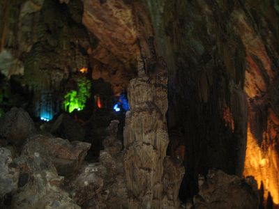
A scene inside Phong Nha Cave, the most beautiful caves in Phong Nha Ke Bang National Park
The Phong Nha–Ke Bang karst has evolved since the Paleozoic (some 400 million years ago), the oldest major karst area in Asia. Massive tectonic changes, comprising a series of rock types that inter-bed in complex ways, have occurred. As many as seven different major levels of karst development have occurred as a result of tectonic uplift and changing sea levels, making the karst landscape of the park extremely complex with high a geodiversity and many geomorphic features. Like much of Vietnam, the limestones of Phong Nha have inter-bedded with a number of other rocks. Investigations point to sulfurous solution and hydrothermal action playing an important role in shaping the broad-scale landscape and the caves.
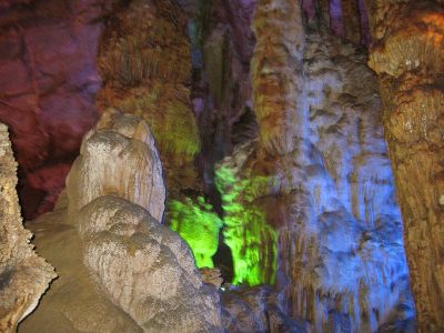
Spectacular stalagmite in a cave in the Phong Nha Ke Bang National Park.
Five stages of the Earth's crust development and movement impacted Phong Nha-Ke Bang: Late Ordovician-Early Silurian Stage (about 450 Ma), Middle-late Devonian Stage (about 340 Ma), Carboniferous-Permian (about 300 Ma), Mesozoic Orogenic stage, and Cenozoic stage. Phong Nha-Ke Bang also contains two dozen mountain peaks over 1,000 meters high. Noteworthy peaks include the Peak Co Rilata with a height of 1,128 meters and the Peak Co Preu with a height of 1,213 meters.
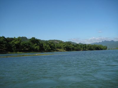
Son River in the Phong Nha Ke Bang National Park
Besides the grotto and cave systems, Phong Nha has the longest underground river in the world. The Son and Chay are the main rivers in the national park. Most of caves have been shaped by Son and Chay Rivers. The Son River flows into the mouth of the Phong Nha cave and continues underground. Called the Nam Aki River, it emerges 20 kilometers to the south near Pu-Pha-Dam Mountain. Ten spectacular streams, springs and waterfalls exist in Phong Nha-Ke Bang area, namely: Gió waterfall, Madame Loan waterfall, Mọc stream erupting from a limestone mount range, and Trạ Ang stream.
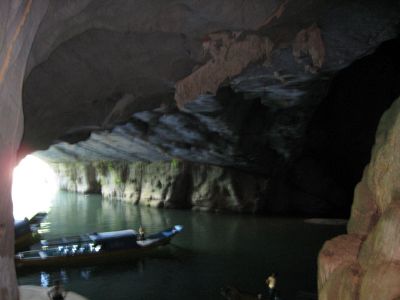
Underground river in Phong Nha cave
Phong Nha-Ke Bang covers 300 different grottoes and caves. Phong Nha cave has been evaluated as the top cave in the world due to its four records: the longest underground river, the highest and longest cave, broadest and most beautiful fine sand beaches inside the caves, the most spectacular stalagmites and stalactites.[4] According to the assessment of UNESCO, "The karst formation of Phong Nha-Ke Bang National Park has evolved since the Paleozoic (some 400 million years ago) and so is the oldest major karst area in Asia"> and "Phong Nha displays an impressive amount of evidence of earth’s history. It is a site of very great importance for increasing our understanding of the geologic, geomorphic and geo-chronological history of the region."[1]
The Phong Nha cave
The Phong Nha cave inspired the name for the Park. Famous rock formations have been given names such as the "Lion," the "Fairy Caves," the "Royal Court," and the "Buddha." The cave measures 7729 meters long, contains fourteen grottoes, with a 13,969 meter long underground river. Scientists have surveyed 44.5 kilometers of grottoes in the cave so far, but visitors may explore only a distance of 1500 meters.[2] The main Phong Nha cave includes fourteen chambers, connected by an underwater river that runs for 1.5 kilometers. Secondary corridors branch off in several directions. The Outer Cave and some of the Inner Caves have roofs that tower between twenty five and forty meters above the water level. Notable caves and grottoes include Phong Nha Cave system, Vom Cave systems, the Tien Son Cave, and Thien Duong Cave.
Biodiversity in the park
Florae
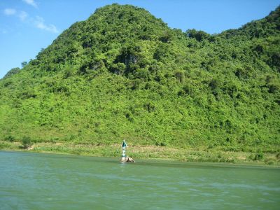
Trees on the limestone mounts, a typical florae in Phong Nha-Ke Bang National Park
The park belongs to the Annamites eco-region. Tropical dense moist evergreen forest on limestone under 800 meters above sea level comprises by far the largest vegetation type. Forest cover 96.2 percent of the national park, 92.2 percent constituting intact primary forest. According to the results of initial surveys, the primary tropical forest in Phong Nha-Ke Bang 140 families, 427 genera, and 751 species of vascular plants, including thirty six endangered species.
Hopea sp., Sumbaviopsis albicans, Garcinia fragraeoides, Burretionendron hsienmu, Chukrasia tabularis, Photinia aroboreum, and Dysospyros saletti constitute the most common tree species in the park. Seedlings can only grow in holes and cracks in the limestone where soil has accumulated, so in general regeneration after disturbance proceeds slowly. evergreen tree species with scattered deciduous trees such as Dipterocarpus kerri, Anogeissus acuminate, Pometia pinnata, and Lagerstroemia calyculata dominate the forest.
The dominant plant families include the Lauraceae, Fagacaeae, Theaceae and Rosaceae, with some scattered gymnosperms such as Podocarpus imbricatus, Podocarpus neriifolius, and Nageia fleuryi. A 5000-ha forest of Calocedrus macrolepis on limestone (Calocedrus rupestris) mounts with about 2,500 trees, 600 per hectare exists, constituting the largest forest with this tree in Vietnam. Most of the trees have been dated at 500 to 600 years old.
Fauna
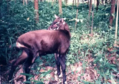
Saola, a species found in Phong Nha-Ke Bang National Park
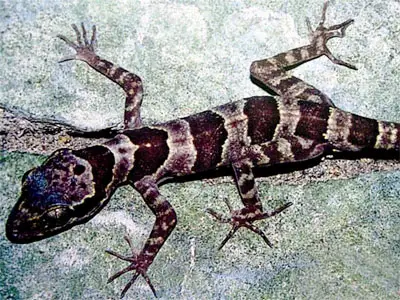
Cyrtodactylus phongnhakebangensis, a newly found species in Phong Nha-Ke Bang National Park
The forest serves as home to ninety eight families, 256 genera and 381 species of vertebrates. Sixty-six animal species have been listed in Vietnam's Red Data Book and twenty three other species in the World Red Book of Endangered Species. In 2005, a group of Vietnamese biologists, together with biologists working for the park, Cologne Zoo in Germany and the Saint Petersburg Wild Zoology Institute in Russia discovered a new species of gecko (Lygosoma boehmeiwas).[5]
The Gaur, and one specie of eel, have been discovered in the park.[2] The Park hosts significant populations of primates, with ten species and sub-species. Those include the globally vulnerable Pig-tailed Macaque, Assamese Macaque, Stump-tailed Macaque, and White-cheeked Crested Gibbon (Nomascus leucogenys and Nomascus leucogenys siki). The Park hosts the largest population of Francois' Langur in Vietnam, including two different forms of the specie. A population of Hatinh Langur and Black Langur, the largest population of those species in the world and the only population represented in a protected area, inhabit the park.
Other endangered large mammals include the Mainland Serow (Capricornis sumatraensis), Giant Muntjac (Megamuntiacus vuquangensis), and the Saola (Pseudoryx nghetinhensis). The Asiatic Black Bear (Selenarctos thibetanus) and Sun Bear (Helarctos malayanus) live in the park. Other smaller mammals include Sunda Pangolins (Manis javanica) and the recently discovered Striped hare, called locally 'tho van' (Nesolagus timminsii). Ten bat species listed in the IUCN List of Threatened Species have been recorded in the park.
Of the fifty nine recorded reptile and amphibian species, the Vietnam's Red Data Book lists eighteen while the IUCN Red List of Threatened Animals lists six. The seventy two fish species include four species endemic to the area, including Chela quangbinhensis.[2] The park offers refuge to over 200 bird species, inclusive of several rare birds such as: Chestnut-necklaced Partridge, Red-collared Woodpecker, Brown Hornbill, Sooty Babbler and Short-tailed Scimitar-babbler. The Vietnamese Pheasant (Lophura hatinhensis) and Imperial Pheasant (Lophura imperialis) species have been spotted in Phong Nha-Kẻ Bàng area.[3]
In an initial survey, Russian and Vietnamese scientists from Vietnam-Russia Tropical Centre (funded by WWF) recorded 259 butterfly species in eleven families. Almost all major butterfly taxa in Vietnam have been sighted in Phong Nha-Ke Bang National Park.[3]
Human History
Neolithic axe heads and similar artifacts found in some of the caves give evidence of the first human habitation in the area. An ancient hieroglyphic script of the Cham ethnic minority had been found in Phong Nha-Ke Bang .[2] In 1995, the Archeological Institute of Vietnam noted Phong Nha cave as an extremely important archeological site, suggesting that the Bi Ky grotto may have sheltered a Champa mosque from the ninth to eleventh century. Inside Phong Nha cave, many Champa style ceramics with lotus-shaped ruby-colored, and slight pink mouth earthenware vases have been found.
In early twentieth century, cave explorers and researchers from France and the UK discovered several ancient Champa and Vietnamese relics, such as altars, steles, hieroglyphic script, sculptures, stone statues, Buddha statues, and Chinese artifacts. King Ham Nghi built a base for the Vietnamese resistance against the French colonialism during the late nineteenth century.[2] During the Vietnam War, the caves served as an impregnable major base of the North Vietnamese Army.
Management issues
Management activities
The Park Management Board includes 115 people serving as zoologists, botanists, silviculturists, and socio-economists. The management staff lacks the authority to fine violators and lacks equipment like helicopters and sufficient funds, hamstringing their attempts to efficiently deal with natural and human threats to the park.[2] The government has created an eighteen hectare semi-wild zone, surrounded by electrical wire fence, for the primate species. The preserve had been sponsored by Zoologische Gesellschaft Frankfurt (Germany) to provide a sanctuary for ten species of primates, including Trachypithecus francoisi hatinhensis, red-shanked douc langur or Pygathrix nemaeus nemaeus).
Threats to biodiversity
Two villages, Arem and Ma Coong, exist in the core zone of the Phong Nha-Ke Bang National Park. The buffer zone has a population of 52,001, mainly Kinh people and other minority groups of Chut and Van Kieu. Many of the villagers living in the buffer zone exploit the forest for a livelihood. The increase of visitors to the park has increased water pollution & rubbish pollution. Hunting by locals has been a significant threat to the wildlife, especially the wild pig, binturong, rare eels like Anguilla marmorota and Anguilla bicolo, and primates.
Locals cutting of rare wood such as Go Mun wood (Diospyros spp.) and Go Hue wood (Dalbergia rimosa) has harmed the forests. During the construction of roads, blasts and construction work have kept several primates away from their regular habitat.[6] Limestone in Phong Nha-Ke Bang area has been exploited for commercial purposes by local inhabitants. The provincial government approved a 3600MW coal-fueled thermoelectric plant in Vĩnh Sơn village, Quảng Đông commune, Quang Trach district, forty kilometers northeast of the national park. The project has many environmentalists deeply concerned.
International funding
The German government announced on November 3, 2005, funding of 12.6 million euros for the purpose of protecting the biodiversity of the park. They earmarked the funds for the park's management board. In 2007, the German government donated a further 1.8 million euros to Vietnam for protection of the park. And in 2015, the German government approved a project on sustainable conservation and management work, with a total investment of 2.175 million Euro (EUR) (2.324 million USD).[7]
Fauna & Flora International (FFI) donated USD 132,000 to Phong Nha-Ke Bang National Park Management Board for the protection of primates in the park as well as in the buffer zone. In 1998, Fauna & Flora International conducted a training program for the management staff of the park. The British Commission for International Development sponsored a fund for the WWF to protect the biodiversity in the park and in the adjacent Hin Namno Nature Reserve in Laos. The Fauna & Flora International also received environmental funding from the British Department for Environment, Food and Rural Affairs to implement a campaign targeted at increasing awareness about biodiversity protection among tourists and locals.
Gallery
The mouth of Phong Nha cave with underground river
Inside Phong Nha Cave in the Phong Nha Ke Bang
Part of Phong Nha-Ke Bang National Park
Stalactites in the Dry Cave of Phong Nha Ke Bang National Park
Phong Nha Ke Bang National Park
Phong Nha Ke Bang National Park
Phong Nha Ke Bang National Park
Phong Nha Ke Bang National Park
Notes
- ↑ 1.0 1.1 1.2 Phong Nha-Ke Bang National Park UNESCO World Heritage Convention. Retrieved September 18, 2023.
- ↑ 2.0 2.1 2.2 2.3 2.4 2.5 2.6 2.7 Phong Nha-Ke Bang National Park United Nations Environment Programme. Retrieved September 18, 2023.
- ↑ 3.0 3.1 3.2 Di sản thiên nhiên thế giới - Vườn quốc gia Phong Nha - Kẻ Bàng (Quảng Bình) 'Vietnam Geological and Mineral Resources Department. Retrieved September 18, 2023.
- ↑ Di sản thiên nhiên Phong Nha Kẻ Bàng Peace Tour Co. Retrieved September 18, 2023.
- ↑ Lygosoma boehmei Reptile Database. Retrieved September 18, 2023.
- ↑ Vietnam: Road-building threatens Phong Nha Nature Reserve World Rainforest Movement, December 13, 2000. Retrieved September 18, 2023.
- ↑ 2 mln EUR in ODA mobilised for Phong Nha –Ke Bang Vietnam Plus (November 24, 2015). Retrieved September 18, 2023.
References
ISBN links support NWE through referral fees
- Averyanov, Leonid, N.T. Hiep, and P.K. Loc. Flora and vegetation of areas allied to Phong Nha – Ke Bang. LAP LAMBERT Academic Publishing, 2012. ISBN 978-3659217845
- Đại học quó̂c gia Hà Nội. Kỳ quan hang động Việt Nam = The wonders of Vietnamese caves. [Hà Nội]: Trung tâm Bản đò̂ và Tranh ảnh Giáo dục, 2001. OCLC 49890530
- Lambert, F. R., J. C. Eames, and N. Cu. "The habitat, status, vocalizations and breeding biology of Blue-rumped Pitta Pitta soror annamensis in central Vietnam." Forktail 11 (1996): 151-154. OCLC 194944824
- Nguyẽ̂n, Bính, and Quang Huy. Thơ Nguyẽ̂n Bính. Hà Nội: Văn hóa - thông tin, 1993. OCLC 64087230
- Timmins, R.J. A preliminary assessment of the conservation importance and conservation priorities of the Phong Nha-Ke Bang proposed national park, Quang Binh province, Vietnam = Đánh giá sơ bộ về ý nghĩa và những ưu tiên bảo tồn dề xuất Vuờn Quốc gia Phong Nha-Kẻ Bàng, tỉnh Quảng Bình, Việt Nam. Hanoi: Fauna & Flora International—Indochina Programme, 1999. OCLC 43973196
External links
All links retrieved September 18, 2023.
| National parks of Vietnam |
|---|
| Ba Bể · Ba Vi · Bach Ma · Bai Tu Long · Ben En ·Bidoup Nui Ba · Bu Gia Mat · Cat Ba · Cat Tien · Chu Mom Ray · Chư Yang Sin · Con Dao · Cuc Phuong · Hoang Lien · Kon Ka Kinh · Lo Go Xa Mat · Mui Ca Mau · Nui Chua · Phong Nha-Ke Bàng · Phu Quoc ·Phuoc Binh · Pu Mat · Tam Dao · Tram Chim · U Minh Ha · U Minh Thuong · Vu Quang · Xuan Son · Xuan Thuy · Yok Don |
|
Credits
New World Encyclopedia writers and editors rewrote and completed the Wikipedia article
in accordance with New World Encyclopedia standards. This article abides by terms of the Creative Commons CC-by-sa 3.0 License (CC-by-sa), which may be used and disseminated with proper attribution. Credit is due under the terms of this license that can reference both the New World Encyclopedia contributors and the selfless volunteer contributors of the Wikimedia Foundation. To cite this article click here for a list of acceptable citing formats.The history of earlier contributions by wikipedians is accessible to researchers here:
The history of this article since it was imported to New World Encyclopedia:
Note: Some restrictions may apply to use of individual images which are separately licensed.