Mount Fuji
| Mount Fuji 富士山 | |
|---|---|
 Mt. Fuji at sunrise from Lake Kawaguchi | |
| Elevation | 3,776 metres (12,388 feet) |
| Location | Honshu, Japan |
| Prominence | 3,776 m 12,388 feet Ranked 35th |
| Geographic coordinates | |
| Type | Stratovolcano |
| Last eruption | 1707 |
| First ascent | 663 by an anonymous monk |
| Easiest Climbing route | hike |

Mount Fuji (富士山 Fuji-san, IPA: [ɸɯʥisaɴ]) is the highest mountain in Japan. It straddles the boundary of Shizuoka and Yamanashi prefectures just west of Tokyo, from where it can be seen on a clear day. It is located near the Pacific coast of central Honshu. Three small cities surround it, they are: Gotemba (East), Fuji-Yoshida (North) and Fujinomiya (Southwest).
Mount Fuji is a well-known symbol of Japan and is frequently depicted in art and photographs, as well as visited by sightseers and climbers.
Geography
Mt. Fuji has five lakes around it: Lake Kawaguchi, Lake Yamanaka, Lake Sai, Lake Motosu and Lake Shoji. They, and nearby Lake Ashi, provide excellent views of the mountain. It is part of the Fuji-Hakone-Izu National Park.
Geology
Scientists have identified four distinct phases of volcanic activity in the formation of Mt. Fuji. The first phase, called Sen-komitake, is composed of an andesite core recently discovered deep within the mountain. Sen-komitake was followed by the "Komitake Fuji," a basalt layer believed to be formed several hundred thousand years ago. Approximately 100,000 years ago, "Old Fuji" was formed over the top of Komitake Fuji. The modern, "New Fuji" is believed to have formed over the top of Old Fuji by around 10,000 years ago. [1]
The volcano is currently classified as active with a low risk of eruption. The last recorded eruption occurred in 1707 during the Edo period. At this time, a new crater, along with a second peak, named Hōei-zan after the era name, formed halfway down its side.
Mt. Fuji is located at the point where the Eurasian Plate (or the Amurian Plate), the Okhotsk Plate, and the Philippine Plate meet. Those plates form the western part of Japan, the eastern part of Japan, and the Izu Peninsula respectively.
Name
Variations
Fuji-san is sometimes referred to as Fuji Yama in some Western texts, because the third character of its name, 山 meaning mountain, can also be pronounced "yama". (See kanji readings.) However, this name is obsolete in Japan. In fact, the Japanese phrase "Fujiyama, geisha" means the Japan that is misunderstood by the West. The suffix -san, meaning a mountain, has nothing to do with the Japanese title -san used for people.
Additionally, "Fuji" may be spelled "Huzi" when using Nippon-shiki romanization. Nevertheless, the standard spelling is generally considered a more accurate reflection of the Japanese pronunciation.
Other Japanese names for Mt. Fuji, which have become obsolete or poetic, include Fuji-no-Yama (ふじの山, the Mountain of Fuji), Fuji-no-Takane (ふじの高嶺, the High Peak of Fuji), Fuyō-hō (芙蓉峰, the Lotus Peak), and Fu-gaku (富岳 or 富嶽, the first character of 富士, Fuji, and 岳, mountain).
Etymology
The current kanji for Mt. Fuji, 富 and 士, mean wealth or abundant and a man with a certain status respectively, but it is likely these characters were selected because their pronunciations match the syllables of the name. They do not indicate the meaning of the name.
The origin of the name Fuji is unclear. An early folk etymology claims that Fuji came from 不二 (not + two), meaning without equal or nonpareil. Another claims that it came from 不尽 (not + exhaust), meaning neverending.
A Japanese classical scholar in Edo era, Hirata Atsutane speculated that the name is from a word meaning "a mountain standing up shapely as an ear (ho) of a rice plant". A British missionary John Batchelor (1854-1944) argued that the name is from Ainu word for 'fire' (huchi) of fire-deity (huchi kamuy), which had been denied by a Japanese linguist Kyosuke Kindaichi (1882-1971) in the viewpoint of phonetic development (sound change). It is also pointed out that huchi means an 'old woman' and ape is the word for 'fire', ape huchi kamuy being the fire deity. Researches on the distribution of place names that include fuji as a part also suggest the origin of the word fuji is in Yamato language rather than Ainu. A Japanese toponymist Kanji Kagami argued that the name has the same root as 'wisteria' (fuji) and 'rainbow' (niji, but with an alternative word fuji), and came from its "long well-shaped slope". [1] [2] [3] [4]
A text of the Tale of the Bamboo Cutter says that the name came from "immortal" (不死 fushi, fuji) and also from the image of abundant (富 fu) soldiers (士 shi, ji)† ascending the slopes of the mountain. [5]
† Although the word 士 can mean a soldier (兵士 heishi, heiji), or a samurai (武士 bushi), its original meaning is a man with a certain status.
History
It is thought that the first ascent was in 663 by an anonymous monk. The summit has been thought of sacred since ancient times and was forbidden to women until the Meiji Era.
The first ascent by a foreigner was by Sir Rutherford Alcock in 1860.
Today, it is a popular tourist destination and common destination for mountain-climbing (see below).
Mt. Fuji is an attractive volcanic cone and a frequent subject of Japanese art. The most renowned work is Ukiyo-e painter Hokusai's masterpiece 36 Views of Mount Fuji. It is also mentioned in Japanese literature throughout the ages and the subject of many poems.
Mt. Fuji also houses a warrior tradition: ancient samurai used the base of the mountain as a remote training area, near the present day town of Gotemba. The shogun Minamoto no Yoritomo held yabusame in the area in the early Kamakura period. As of 2006, the Japan Self-Defense Forces and the United States Marine Corps operate military bases near Mount Fuji.
- See also Historic eruptions of Mt.Fuji
Climbing Mount Fuji

The most popular period for people to hike up Mt. Fuji is from July 1 to August 27, while huts and other facilities are operating. Buses used to get to the fifth station start running on July 1.
There are currently 4 major routes from the fifth station to the summit with additional 4 routes from the foot of the mountain. The 4 major routes from the fifth station are clockwise Kawaguchiko, Subashiri, Gotemba, and Fujiyomiya routes. The four routes from the foot of the mountain are Shojiko, Yoshida, Suyama, and Murayama routes. The stations in different routes are located in different sea levels. The highest fifth station is located at Fujinomiya, followed by Kawaguchi, Subashiri, and Gotemba.
Even though it is only the second highest fifth station, Kawaguchiko route is the most popular route because of its large parking area. During the summer season, most Fuji-san climbing tour busses arrive there. The next popular is Fujinomiya route which has the highest fifth station, followed by Subashiri and Gotemba. Even though most climbers do not climb Subashiri and Gotemba routes, there are many who decent these routes because of their ash-covered paths. From the seventh station to near the fifth station, one could literally run down these ash-covered paths in approximately 30 minutes.
Four routes from the foot of the mountain offer historical sites. Murayama route is the oldest Mount Fuji route and Yoshida route still has many old shrines, teahouses, and huts along its path. These routes are gaining popularity recently and are being restored. However, don't expect to meet too many people climbing from the foot of the mountain. Also, bears have been sighted along the Yoshida route.
An estimated 200,000 people climb Mount Fuji every year, 30% of which are foreigners. The ascent can take anywhere between 3 and 7 hours while the descent can take from 2 to 5 hours. The hike is divided into ten stations and there are paved roads up to the fifth station, which is about 2300 meters above sea level. Huts at this station are not usually manned at night for nighttime climbers. The sheer number of climbers each year has created a litter problem on the road to the summit, but this has not decreased the mountain's popularity.
There are 8 peaks. The highest point in Japan is where there used to be a radar building. Climbers are able to visit these peaks by going around the crater.
Aokigahara
Aokigahara is a forest that lies at the base of the mountain. Many legends surround it; according to one, the rock of the mountain contains large iron deposits that cause compasses and even GPS to stop functioning, making it extremely easy to get lost. However, such legends are untrue; the magnetic field generated by the iron is too weak to have any significant effect. Both the Japan Self Defense Force and the U.S. Marines run regular training exercises throughout the forest, during which compasses, GPS equipment and other navigational electronics have been verified as functioning properly.
The caverns found in the Aokigahara forest contain ice even during summer. Legends tell of monsters, ghosts, and goblins haunting the forest, adding to its sinister reputation. Furthermore, Aokigahara Jukai (The Sea of Trees) is the top suicide area in Japan; the spirits of those who kill themselves there are said to be cursed to forever haunt the area. Over 78 bodies have been discovered, prompting officials to put up signs prohibiting suicide in the forest.
Trivia
- Singer Kyu Sakamoto once had bearers carry a grand piano to the summit for a concert.
- The Atari and Infiniti logos are both stylized representations of Mount Fuji. Though some say the Infiniti logo is just a road.
- Mount Taranaki in New Zealand looks so similar to Mount Fuji from some angles that it has been used as a substitute in films, such as The Last Samurai.
- Volcan Osorno in south Chile also has a striking similarity to Mount Fuji.
- Before Mt. St. Helens erupted in 1980, it was considered the Mount Fuji of America.
- Mt Fuji and the surrounding area is a frequently utilised battleground in the Godzilla series, most notably in Destroy All Monsters, Godzilla vs The Smog Monster and Godzilla: Final Wars.
See also
- Geography of Japan
- Historic eruptions of Mt.Fuji
- Hoei eruption of Mount Fuji
Pictures of Mount Fuji
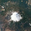
Image of Mount Fuji taken by NASA.
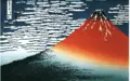
Red Fuji by Hokusai
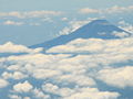
Image of Mount Fuji taken from an airplane.
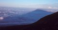
Shadow of Mount Fuji on the upper side of the cloud-layer
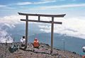
Torii near summit of Mount Fuji
- Mt Fuji Summit.jpg
Buildings and hikers at the summit of Mount Fuji
- Mountfujijapan.jpg
Mount Fuji with a Shinkansen and Sakura blossoms in the foreground
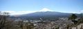
Mount Fuji seen from mount Tanjo on a clear day in mid October


ReferencesISBN links support NWE through referral fees
External links
- Live Webcams of Mt. Fuji
- Satellite picture by Google Maps
- Travel guide to Mount Fuji from Wikitravel
- PDMZ.com's year-round pictures of Mt. Fuji
- Information about climbing Mt.Fuji
- Kawaguchi Lake Immersive Virtual Tour
ar:جبل فوجي bg:Фуджи bn:ফুজিয়ামা cs:Fudži da:Fuji de:Fujisan et:Fuji es:Monte Fuji fr:Mont Fuji gl:Monte Fuji ko:후지 산 id:Gunung Fuji it:Monte Fuji he:הר פוג'י ka:ფუძი la:Mons Fusius hu:Fudzsi nl:Fuji (vulkaan) ja:富士山 no:Fuji-san pl:Fuji pt:Monte Fuji ro:Fuji ru:Фудзи sk:Fudžisan su:Gunung Fuji fi:Fuji sv:Fuji ta:ஃவூஜி மலை th:ภูเขาฟูจิ vi:Núi Phú Sĩ uk:Фудзі (гора) zh:富士山
Credits
New World Encyclopedia writers and editors rewrote and completed the Wikipedia article in accordance with New World Encyclopedia standards. This article abides by terms of the Creative Commons CC-by-sa 3.0 License (CC-by-sa), which may be used and disseminated with proper attribution. Credit is due under the terms of this license that can reference both the New World Encyclopedia contributors and the selfless volunteer contributors of the Wikimedia Foundation. To cite this article click here for a list of acceptable citing formats.The history of earlier contributions by wikipedians is accessible to researchers here:
The history of this article since it was imported to New World Encyclopedia:
Note: Some restrictions may apply to use of individual images which are separately licensed.