Compass

A compass (or mariner's compass) is a navigational instrument for finding directions on the earth. It consists of a magnetized pointer free to align itself accurately with Earth's magnetic field, which is of great assistance in navigation. The cardinal points are north, south, east and west. A compass can be used in conjunction with a chronometer and a sextant to provide a very accurate navigation capability. This device greatly improved maritime trade by making travel safer and more efficient. An early form of compass was invented in China in 271 C.E. and is one of four great inventions of ancient China. The familiar mariner's compass was invented in Europe around 1300.
More technically, a compass is a magnetic device using a needle to indicate the direction of the magnetic north of a planet's magnetosphere. Any instrument with a magnetized bar or needle turning freely upon a pivot and pointing in a northerly and southerly direction can be considered a compass. A compass dial is a small pocket compass with a sundial. A variation compass, a specific instrument with a delicate construction, is used by observing variations of the needle. A gyrocompass or astrocompass can also be used to ascertain true north.


Pre-history
Prior to the introduction of the compass, directions at sea were determined primarily by the position of celestial bodies. Navigation was supplemented in some places by the use of soundings. Difficulties arose where the sea was too deep for soundings and conditions were continually overcast or foggy. Thus the compass was not of the same utility everywhere. For example, the Arabs could generally rely on clear skies in navigating the Persian Gulf and the Indian Ocean (as well as the predictable nature of the monsoons). This may explain in part their relatively late adoption of the compass. Mariners in the relatively shallow Baltic made extensive use of soundings.
Developments in Chinese
Due to the place of its first appearance, most scholars credit at present the invention of the compass to China. Since there has been frequently confusion as to when a compass was introduced for the first time, it may be appropriate to list the important events leading up to its invention in chronological order:
- The earliest Chinese literary reference to magnetism lies in a fourth century B.C.E. book called Book of the Devil Valley Master (鬼谷子): "The lodestone makes iron come or it attracts it."[1]
- The first mention of the magnetic attraction of a needle is to be found in a Chinese work composed between 20 and 100 C.E. (Louen-heng): "A lodestone attracts a needle."[2]
- The earliest reference to a magnetic device as a direction finder is recorded in a Song dynasty book dated to 1040-1044. Here we find a description of an iron "south-pointing fish" floating in a bowl of water, aligning itself to the south. The device is recommended as a means of orientation "in the obscurity of the night." There is, however, no mention of a use for navigation, nor how the fish was magnetized.[3]
- The first incontestable reference to a magnetized needle in Chinese literature appears as late as 1086.[4] The Dream Pool Essay written by Song Dynasty scholar Shen Kua contained a detailed description of how geomancers magnetized a needle by rubbing its tip with lodestone, and hung the magnetic needle with one single strain of silk with a bit of wax attached to the center of the needle. Shen Kua pointed out that a needle prepared this way sometimes pointed south, sometimes north.
- The earliest recorded actual use of a magnetized needle for navigational purposes then is to be found in Zhu Yu's book Pingzhou Table Talks (Pingzhou Ke Tan) of 1117 C.E.: "The navigator knows the geography, he watches the stars at night, watches the sun at day; when it is dark and cloudy, he watches the compass."
- A pilot's compass handbook titled Shun Feng Xiang Song (Fair Winds for Escort) in the Oxford Bodleian Library contains great details about the use of compass in navigation.
- "Earliest records show a spoon shaped compass made of lodestone or magnetite ore, referred to as a "South-pointer" dating back to sometime during the Han Dynasty (2nd century B.C.E. to 2nd century CE). The spoon-shaped instrument was placed on a cast bronze plate called a "heaven-plate" or diviner's board that had the eight trigrams (Pa Gua) of the I Ching, as well as the 24 directions (based on the constellations), and the 28 lunar mansions (based on the constellations dividing the Equator). Often, the Big Dipper (Great Bear) was drawn within the center disc. The square symbolized earth and the circular disc symbolized heaven. Upon these were inscribed the azimuthal points relating to the constellations. Its primary use was that of geomancy (prognostication) to determine the best location and time for such things as burials. In a culture that placed extreme importance on reverence for ancestors, this remained an important tool well into the nineteenth century. Even in modern times there are those who use this divination concepts of Feng Shui (literally, of wind and water) for locating buildings or fortuitous times and locations for almost any enterprise. There is a story that the first Chin emperor used the divining board and compass in court to affirm his right to the throne. Primarily, the compass was used for geomancy for a long time before it was used for navigation." [5]
Question of Diffusion

There is much debate on what happened to the compass after its first appearance with the Chinese. Different theories include:
- Travel of the compass from China to the Middle East via the Silk Road, and then to Europe
- Direct transfer of the compass from China to Europe, and then later from Europe to the Middle East
- Independent creation of the compass in the Europe and then its transfer thereafter to the Middle East.
The latter two are supported by evidence of the earlier mentioning of the compass in European works rather than Arabic. The first European mention of a magnetized needle and its use among sailors occurs in Alexander Neckam's De naturis rerum (On the Natures of Things), probably written in Paris in 1190.[6] Other evidence for this includes the Arabic word for "Compass" (al-konbas), possibly being a derivation of the old Italian word for compass.
In the Arab world, the earliest reference comes in The Book of the Merchants' Treasure, written by one Baylak al-Kibjaki in Cairo about 1282.[7] Since the author describes having witnessed the use of a compass on a ship trip some forty years earlier, some scholars are inclined to antedate its first appearance accordingly. There is also a slightly earlier non-Mediterranean Muslim reference to an iron fish-like compass in a Persian talebook from 1232.[8]
Question of independent European invention

There have been various arguments put forward whether the European compass was an independent invention or not:
Arguments that support independent invention:
- The navigational needle in Europe points invariably north, whereas always south in China.
- The European compass showed from the beginning sixteen basic divisions, not twenty-four as in China.
- The apparent failure of the Arabs to function as possible intermediaries between East and West due to the earlier recorded appearance of the compass in Europe (1190) than in the Muslim world (1232, 1242, or 1282).
Arguments against independent invention:
- The temporal priority of the Chinese navigational compass (1117) as opposed to the European compass (1190).
Impact in the Mediterranean
In the Mediterranean the practice from ancient times had been to curtail sea travel between October and April, due in part to the lack of dependable clear skies during the Mediterranean winter (and much of the sea is too deep for soundings). With improvements in dead reckoning methods, and the development of better charts, this changed during the second half of the thirteenth century. By around 1290 the sailing season could start in late January or February, and end in December. The additional few months were of considerable economic importance; it enabled Venetian convoys, for instance, to make two round trips a year to the eastern Mediterranean, instead of one.
Around the time Europeans learned of the compass, traffic between the Mediterranean and northern Europe increased, and one factor may be that the compass made traversal of the Bay of Biscay safer and easier.
Modern liquid-filled compass
In 1936 Tuomas Vohlonen of Finland invented and patented the first successful portable liquid-filled compass designed for individual use.[9]
Construction of a simple compass
A magnetic rod is required when constructing a compass. This can be created by aligning an iron or steel rod with Earth's magnetic field and then tempering or striking it. However, this method produces only a weak magnet so other methods are preferred. This magnetised rod (or magnetic needle) is then placed on a low friction surface to allow it to freely pivot to align itself with the magnetic field. It is then labeled so the user can distinguish the north-pointing from the south-pointing end; in modern convention the north end is typically marked in some way, often by being painted red.
Flavio Gioja (fl. 1302), an Italian marine pilot, is sometimes credited with perfecting the sailor's compass by suspending its needle over a fleur-de-lis design, which pointed north. He also enclosed the needle in a little box with a glass cover.

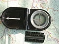
Modern hand-held navigational compasses use a magnetized needle or dial inside a fluid-filled (oil, kerosene, or alcohol is common) capsule; the fluid causes the needle to stop quickly rather than oscillate back and forth around magnetic north. Most modern recreational and military compasses integrate a protractor with the compass, using a separate magnetized needle. In this design the rotating capsule containing the magnetized needle is fitted with orienting lines and an outlined orienting arrow, then mounted in a transparent baseplate containing a direction-of-travel (DOT) indicator for use in taking bearings directly from a map. Other features found on some modern handheld compasses are map and romer scales for measuring distances and plotting positions on maps, luminous markings or bezels for use at night or poor light, various sighting mechanisms (mirror, prism, etc.) for taking bearings of distant objects with greater precision, 'global' needles for use in differing hemispheres, adjustable declination for obtaining instant true bearings without resort to arithmetic, and devices such as inclinometers for measuring gradients.
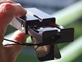
The military forces of a few nations, notably the United States Army, continue to utilize older lensatic card compass designs with magnetized compass dials instead of needles. A lensatic card compass permits reading the bearing off of the compass card with only a slight downward glance from the sights (see photo), but requires a separate protractor for use with a map. The official U.S. military lensatic compass does not use fluid to dampen needle swing, but rather electromagnetic induction. A 'deep-well' design is used to allow the compass to be used globally with little or no effect in accuracy caused by a tilting compass dial. As induction forces provide less damping than fluid-filled designs, a needle lock is fitted to the compass to reduce wear, operated by the folding action of the rear sight/lens holder. The use of air-filled induction compasses has declined over the years, as they may become inoperative or inaccurate in freezing temperatures or humid environments.
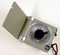
Other specialty compasses include the optical or prismatic hand-bearing compass, often used by surveyors, cave explorers, or mariners. This compass uses an oil-filled capsule and magnetized compass dial with an integral optical or prismatic sight, often fitted with built-in photoluminescent or battery-powered illumination. Using the optical or prism sight, such compasses can be read with extreme accuracy when taking bearings to an object, often to fractions of a degree. Most of these compasses are designed for heavy-duty use, with solid metal housings, and many are fitted for tripod mounting for additional accuracy.
Mariner's compasses can have two or more magnetic needles permanently attached to a compass card. These move freely on a pivot. A lubber line, which can be a marking on the compass bowl or a small fixed needle indicates the ship's heading on the compass card.
Traditionally the card is divided into thirty-two points (known as rhumbs), although modern compasses are marked in degrees rather than cardinal points. The glass-covered box (or bowl) contains a suspended gimbal within a binnacle. This preserves the horizontal position.
Large ships typically rely on a gyrocompass, using the more reliable magnetic compass for back-up. Increasingly electronic fluxgate compasses are used on smaller vessels.
Some modern military compases, like the [SandY-183 http://www.orau.org/PTP/collection/radioluminescent/armycompass.htm](the one pictured) contains the radioactive material Tritium (3H) and a combination of Phosphorous. The SandY-183 contained 120mCi (millicuries) of tritium. The name SandY-183 is derived from the name of the company, Stocker and Yale (SandY).
Solid state compasses
Small compasses found in clocks, cell phones (e.g. the Nokia 5140i) and other electronic gear are Solid-state electronics usually built out of two or three magnetic field sensors that provide data for a microprocessor. Using trigonometry the correct heading relative to the compass is calculated.
Often, the device is a discrete component which outputs either a digital or analog signal proportional to its orientation. This signal is interpreted by a controller or microprocessor and used either internally, or sent to a display unit. An example implementation, including parts list and circuit schematics, shows one design of such electronics. The sensor uses precision magnetics and highly calibrated internal electronics to measure the response of the device to the Earth's magnetic field. The electrical signal is then processed or digitized.
Bearing compass
A bearing compass is a magnetic compass mounted in such a way that it allows the taking of bearings of objects by aligning them with the lubber line of the bearing compass.[10]
Compass correction

Like any magnetic device, compasses are affected by nearby ferrous materials as well as by strong local electromagnetic forces. Compasses used for wilderness land navigation should never be used in close proximity to ferrous metal objects or electromagnetic fields (batteries, car bonnets, engines, steel pitons, wristwatches, and so forth.)
Compasses used in or near trucks, cars or other mechanized vehicles are particularly difficult to use accurately, even when corrected for deviation by the use of built-in magnets or other devices. Large amounts of ferrous metal combined with the on-and-off electrical fields caused by the vehicle's ignition and charging systems generally result in significant compass errors.
At sea, a ship's compass must also be corrected for errors, called compass deviation, caused by iron and steel in its structure and equipment. The ship is swung, that is rotated about a fixed point while its heading is noted by alignment with fixed points on the shore. A compass deviation card is prepared so that the navigator can convert between compass and magnetic headings. The compass can be corrected in three ways. First the lubber line can be adjusted so that it is aligned with the direction in which the ship travels, then the effects of permanent magnets can be corrected for by small magnets fitted within the case of the compass. The effect of ferromagnetic materials in the compass's environment can be corrected by two iron balls mounted on either side of the compass binacle. The coefficient representing the error in the lubber line, while the ferromagnetic effects and the non-ferromagnetic component.


Fluxgate compasses can be calibrated automatically, and can also be programmed with the correct local compass variation so as to indicate the true heading.
Using a compass


The simplest way of using a compass is to know that the arrow always points in the same direction, magnetic North, which is roughly similar to true north. Except in areas of extreme magnetic declination variance (20 degrees or more), this is enough to protect from walking in a substantially different or even opposite direction than expected over short distances, provided the terrain is fairly flat and visibility is not impaired. In fact, by carefully recording distances (time or paces) and magnetic bearings traveled, one can plot a course and a return to one's starting point using the compass alone.
However, compass navigation used in conjunction with a map (terrain association) requires a different compass method. To take a map bearing or true bearing (a bearing taken in reference to true, not magnetic north) to a destination with a protractor compass, the edge of the compass is placed on the map so that it connects the current location with the desired destination (some sources recommend physically drawing a line). The orienting lines in the base of the compass dial are then rotated to align with actual or true north by aligning them with a marked line of longitude (or the vertical margin of the map), ignoring the compass needle entirely. The resulting true bearing or map bearing may then be read at the degree indicator or direction-of-travel (DOT) line, which may be followed as an azimuth (course) to the destination. If a magnetic north bearing or compass bearing is desired, the compass must be adjusted by the amount of magnetic declination before using the bearing so that both map and compass are in agreement. In the given example, the large mountain in the second photo was selected as the target destination on the map.
The modern hand-held protractor compass always has an additional direction-of-travel (DOT) arrow or indicator inscribed on the baseplate. To check one's progress along a course or azimuth, or to ensure that the object in view is indeed the destination, a new compass reading may be taken to the target if visible (here, the large mountain). After pointing the DOT arrow on the baseplate at the target, the compass is oriented so that the needle is superimposed over the orienting arrow in the capsule. The resulting bearing indicated is the magnetic bearing to the target. Again, if one is using 'true' or map bearings, and the compass does not have preset, pre-adjusted declination, one must additionally add or subtract magnetic declination to convert the magnetic bearing into a true bearing. The exact value of the magnetic declination is place-dependent and varies over time, though declination is frequently given on the map itself or obtainable on-line from various sites. If not, any local walker club should know it. If the hiker has been following the correct path, the compass' corrected (true) indicated bearing should closely correspond to the true bearing previously obtained from the map.
This method is sometimes known as the Silva 1-2-3 System, after Silva Compass, manufacturers of the first protractor compasses.[11] [12]
Compass balancing
Because the Earth's magnetic field varies at different latitudes, compasses are often balanced during manufacture. Most manufacturers balance their compass needles for one of five zones, ranging from zone 1, covering most of the Northern Hemisphere, to zone 5 covering Australia and the southern oceans. This balancing prevents excessive dipping of one end of the needle which can cause the compass card to stick and give false readings. Suunto has recently introduced two-zone compasses that can be used in one entire hemisphere, and to a limited extent in another without significant loss of accuracy.
Points of the compass
Originally, many compasses were marked only as to the direction of magnetic north, or to the four cardinal points (north, south, east, west). Later, mariners divided the compass card into 32 equally spaced points divided from the cardinal points.
The 360-degree system later took hold, which is still in use today for civilian navigators. The degree dial spaces the compass markings with 360 equidistant points. Other nations adopted the 'grad' system, which spaces the dial into 400 grads or points.
Most military defense forces have adopted the 'mil' system, in which the compass dial is spaced into 6400 units (some nations use 6000) or 'mils' for additional precision when measuring angles, laying artillery, and so forth.
Gallery
Some different compass systems:
Compass with 400 grads division and conversion table
Swiss army compass with mils division

Land surveyor compass with clinometer
Stratum compass after Prof. Clar


See also
- Azimuth
- Coordinates
- Global positioning system
- Inertial navigation system
- Navigation
- Radio compass
Notes
- ↑ Li Shu-hua, “Origine de la Boussole 11. Aimant et Boussole,” Isis 45 (2) (July 1954): 175
- ↑ Li Shu-hua, 176
- ↑ Li Shu-hua, 181
- ↑ Li Shu-hua, 182f.
- ↑ Susan Silverman, AC. "Chinese Compass 270 C.E." [1] Smith College Museum of ancient inventions.Retrieved May 3, 2008.
- ↑ Barbara M. Kreutz, “Mediterranean Contributions to the Medieval Mariner's Compass,” Technology and Culture 14 (3) (Jul., 1973): 368
- ↑ Kreutz, 369
- ↑ Kreutz, 370
- ↑ Vohlonen Takes a Bearing [2]National Board of Patents and Registration of Finland. Retrieved May 3, 2008.
- ↑ "Using your hand bearing compass"[3] boatus.com. Retrieved May 3, 2008.
- ↑ A dynamic rotating draggable Silva compass is available online to practice setting compass and map bearings: [4]Barcelona Field Studies Centre. Retrieved May 3, 2008.
- ↑ How to use a Compass and Topographic Map [5]travel-island.com. Retrieved May 3, 2008.
ReferencesISBN links support NWE through referral fees
- Aczel, Amir. 2002. The Riddle of the Compass: The Invention that Changed the World. Fort Washington, PA: Harvest Books. ISBN 0156007533.
- Gurney, Alan. 2004. Compass: A Story of Exploration and Innovation. New York, NY: W.W. Norton. ISBN 0393327132.
- Kreutz, Barbara M. 1973. "Mediterranean Contributions to the Medieval Mariner's Compass." In Technology and Culture 14 (3): 367-383.
- Lane, Frederic C. 1963. "The Economic Meaning of the Invention of the Compass." In The American Historical Review 68 (3) (Apr., 1963): 605-617.
- Li Shu-hua. 1954. "Origine de la Boussole 11. Aimant et Boussole." In Isis 45 (2) (Jul., 1954): 175-196.
- Needham, Joseph. Science and Civilization in China, Vol. 4, part 1: Physics. Cambridge Univ. Press, 1962.
- Needham, Joseph, and Colin A. Ronan. Chapter 1, "Magnetism and Electricity." The Shorter Science & Civilisation in China. Vol 3.
- Williams, J.E.D. 1992. From Sails to Satellites. New York, NY: Oxford University Press. ISBN 0198563876.
External links
All links retrieved January 7, 2024.
- USGS Geomagnetism Program
- Evening Lecture To The British Association At The Southampton Meeting by Sir William Thomson (Lord Kelvin) on Friday, August 25, 1882 The Tides. Refers to compass correction by Fourier series.
Credits
New World Encyclopedia writers and editors rewrote and completed the Wikipedia article in accordance with New World Encyclopedia standards. This article abides by terms of the Creative Commons CC-by-sa 3.0 License (CC-by-sa), which may be used and disseminated with proper attribution. Credit is due under the terms of this license that can reference both the New World Encyclopedia contributors and the selfless volunteer contributors of the Wikimedia Foundation. To cite this article click here for a list of acceptable citing formats.The history of earlier contributions by wikipedians is accessible to researchers here:
The history of this article since it was imported to New World Encyclopedia:
Note: Some restrictions may apply to use of individual images which are separately licensed.