Difference between revisions of "Kodiak Island" - New World Encyclopedia
Mary Anglin (talk | contribs) (move section) |
Rosie Tanabe (talk | contribs) |
||
| (46 intermediate revisions by 4 users not shown) | |||
| Line 1: | Line 1: | ||
| − | {{ | + | {{Copyedited}}{{Images OK}}{{Approved}} |
| + | {{Infobox Islands | ||
| + | | name = Kodiak | ||
| + | | image name = Kodiakislandmap.png | ||
| + | | image caption = | ||
| + | | image size = 300px | ||
| + | | locator map = | ||
| + | | native name = | ||
| + | | native name link = | ||
| + | | nickname = | ||
| + | | location = [[Pacific Ocean]] | ||
| + | | coordinates = {{Coord|57|28|N|153|26|W|region:US-AK_type:isle_scale:2000000|display=inline,title}} | ||
| − | [[ | + | | archipelago = [[Kodiak Archipelago]] |
| − | '''Kodiak Island''' is a large island on the south coast of the [[U.S. | + | | total islands = 25 |
| + | | major islands = | ||
| + | | area = {{convert|9293|sqkm|sqmi|0|abbr=on}} | ||
| + | | highest mount = | ||
| + | | elevation = | ||
| + | | country = United States | ||
| + | | country admin divisions title = [[U.S. state|State]] | ||
| + | | country admin divisions = [[Alaska]] | ||
| + | | country admin divisions title 1 = [[Borough (United States)|Borough]] | ||
| + | | country admin divisions 1 = [[Kodiak Island Borough, Alaska|Kodiak Island]] | ||
| + | | country admin divisions title 2 = | ||
| + | | country admin divisions 2 = | ||
| + | | country capital city = | ||
| + | | country largest city = [[Kodiak, Alaska|Kodiak]] | ||
| + | | country largest city population = | ||
| + | | country leader title = | ||
| + | | country leader name = | ||
| + | | country 1 = | ||
| + | | country 1 admin divisions title = | ||
| + | | country 1 admin divisions = | ||
| + | | country 1 capital city = | ||
| + | | country 1 largest city = | ||
| + | | country 1 largest city population = | ||
| + | | country 1 leader title = | ||
| + | | country 1 leader name = | ||
| + | | country 2 = | ||
| + | | country 2 admin divisions title = | ||
| + | | country 2 admin divisions = | ||
| + | | country 2 capital city = | ||
| + | | country 2 largest city = | ||
| + | | country 2 largest city population = | ||
| + | | country 2 leader title = | ||
| + | | country 2 leader name = | ||
| + | | population = | ||
| + | | population as of = | ||
| + | | density = | ||
| + | | ethnic groups = [[Alutiiq]], [[European American|European]], [[Filipino American|Filipino]]<br> other [[Asian Americans|Asian]] and [[Alaska Natives|Indigenous]] peoples,<br>[[Hispanic and Latino Americans|Hispanics]], including [[Asian Hispanic and Latino Americans|Filipino Hispanics]] | ||
| + | | additional info = | ||
| + | }} | ||
| + | '''Kodiak Island''' is a large [[island]] on the south coast of the [[U.S.]] state of [[Alaska]], separated from the Alaska mainland by the [[Shelikof Strait]]. It is the largest island in the [[Kodiak Archipelago]] and at 3,588 square miles (9,293 square km) in area, is the largest island in Alaska and the second-largest island in the [[United States]] (after the [[Hawaii|Big Island of Hawaii]]). It is 100 miles (160 km) long and in width ranges from ten to 60 miles (16 to 100 km). | ||
| − | Kodiak Island is | + | Kodiak Island is [[mountain]]ous and heavily [[forest]]ed in the north and east, but fairly treeless on the south. The island has many ice-free, deep bays that provide sheltered anchorages for boats. The southwestern two-thirds of the island, like much of the Kodiak Archipelago, is part of [[Kodiak National Wildlife Refuge]]. |
| − | + | The most productive [[fishing]] grounds in the world surround Kodiak Island, and its most important industry is fishing. [[Fishery|Fisheries]] include Pacific [[salmon]], Pacific [[halibut]], and [[crab]]. The [[Karluk River]] is famous for its salmon run. [[Logging]], [[ranching]], numerous canneries, and some [[copper]] [[mining]] are also prevalent. The [[Kodiak Bear]] and the [[king crab]] are native to the island. | |
| + | {{toc}} | ||
| + | Kodiak Island is replete with spectacular [[Nature|natural]] beauty. Its generally mild coastal weather and level of precipitation has created a wilderness ideally suited for land, sea and and marine life. Both locals and visitors lovingly call it the "Emerald Isle" due to the lush vegetation that carpets the terrain. | ||
| − | The [[Kodiak | + | ==History== |
| + | [[Image:Shelikhov settlement.jpg|thumb|250px|The settlement of [[Grigory Shelikhov]] on Kodiak Island.]] | ||
| + | [[Alaska]]'s geographical position is at the crossroads between [[Asia]] and [[the Americas]]. | ||
| + | [[Archaeology|Archaeologists]] believe that Alaska was the crossing point for the original settlers of the American continent from Asia about 12,000 years ago. The state has three racially distinct Native populations; the [[Aleut]], the [[Eskimo]], and the [[Native American|Indian]] peoples. The [[Alutiiq]], an Eskimo people, make up the inhabitants of Kodiak Island as well as the Kodiak Archipelago, and the surrounding regions of Prince William Sound, the outer Kenai Peninsula, and the Alaska Peninsula. These native inhabitants lived in sod houses lit by stone oil lamps. Skin-covered [[kayak]]s equipped with sophisticated harpoons were their tools in hunting sea mammals. Their (waterproof) clothing was fashioned from seal intestines, beach grass, and sinew. | ||
| + | |||
| + | Kodiak Island was explored in 1763 by [[Russia]]n fur trader Stepan Glotov. The island was the location of the first permanent Russian settlement in Alaska, founded by [[Grigory Shelikhov]], a fur trader, on [[Three Saints Bay, Alaska|Three Saints Bay]] in 1784 near the present-day village of Old Harbor. The settlement was moved to the site of the present-day city of [[Kodiak, Alaska|Kodiak]] in 1792 and became the center of Russian fur trading. | ||
| + | |||
| + | Under Russian domination, the native peoples were forced to work in "artels"—camps dedicated to sea [[otter]] hunting, [[salmon]] fishing, and [[whaling]]. The Russian clergy introduced the Orthodox faith, which remains a strong force in many Native communities. It is estimated that the island's Native population plummeted from about 9,000 people at contact to just 3,000 by the middle of the nineteenth century, due in large part to infectious [[disease]]s to which they had developed no natural immunity.<ref name=cvb>''Kodiak Island Convention & Visitor's Bureau'' [http://www.kodiak.org/cultural_traditions.html Cultural Time Periods of the Alutiiq] Retrieved June 1, 2008.</ref> | ||
| + | |||
| + | Following the 1867 purchase of Alaska, the island became part of the [[United States]]; Americans settled there and engaged in hunting and fox-farming. Development of the modern fishing industry has characterized the island's history since this time. Many of the native peoples have gradually moved from a subsistence lifestyle into the western market economy. | ||
| + | |||
| + | In 1912 the eruption of [[Novarupta]] on the mainland (erroneously attributed at one time to the more famous [[Mount Katmai]]) blanketed the island with volcanic ash, causing widespread destruction and loss of life. The island was also hit by the 1964 [[Good Friday Earthquake]] and [[tsunami]], which destroyed much of the town of Kodiak. | ||
| + | |||
| + | In 1971, the Alutiiq participated in the Alaska Native Claims Settlement Act, regaining ownership of traditional lands and forming for-profit corporations.<ref name=cvb/> | ||
== Geography == | == Geography == | ||
| − | [[Image:Kodiak | + | [[Image:Rolling Hills and Bay Kodiak NWR.jpg|thumb|Rolling Hills and Bay in Kodiak National Wildlife Refuge]] |
| + | Kodiak is the largest Alaskan [[island]] and the second largest island in the [[United States]]. Covering an area of 3,588 square miles (9,293 square km), it is 100 miles (160 km) long and 10 to 60 miles (16 to 100 km) wide. Together with Afognak, Shuyak, and a number of other nearby islands, it forms an [[archipelago]] that is an extension of the Kenai Mountains.<ref>''Encyclopædia Britannica Online'', 2008, [http://www.britannica.com/EBchecked/topic/320944/Kodiak-Island Kodiak Island] Retrieved June 1, 2008.</ref> | ||
| + | |||
| + | Most of the island is categorized as uplands. The heavily [[forest]]ed eastern coast reaches an elevation of 5,000 feet (1,500 meters). Valleys and lower slopes are covered by sand and gravel from glaciers. The southwestern part of the island, however, is essentially moist tundra, with its vegetation differing from the rest of the island. | ||
| + | A strong surface oceanic current, known as the Kuroshio, ensures warm, moist weather. Kodiak National Wildlife Refuge, established in 1941, covers approximately two-thirds of the island. | ||
| + | ===Kodiak Archipelago=== | ||
| + | Kodiak Island is part of the Kodiak Archipelago, (group of [[island]]s) south of the mainland of [[Alaska]]. It is about 252 miles (405 km) by air south of the city of [[Anchorage, Alaska|Anchorage]] in the [[Gulf of Alaska]]. | ||
| − | + | Kodiak is the archipelago's largest island. To its north is the second largest island, [[Afognak]], which has been extensively logged. Further north is [[Shuyak]]—an island of deep bays which is now in conservation. South of Kodiak are Tugidak and Sitkinak. | |
| − | |||
| − | |||
| − | The [[ | + | The archipelago is about 177 miles (285 km) long and 67 miles (108 km) across, from the [[Barren Islands]] on the north to [[Chirikof Island]] and the [[Semidi Islands]] group on the south. The archipelago contains 5,363 square miles (13,890 sq km) of land. There are about 40 small [[glacier]]s, numerous streams and hundreds of species of land and marine [[animal]]s. Much of its land is forested. |
| − | + | The [[Kodiak Island Borough, Alaska|Kodiak Island Burough]] contains all of the Kodiak Archipelago and some lands on the mainland. The Kodiak National Wildlife Refuge encompasses a large percentage of the land in the archipelago. | |
| − | + | ===Kodiak National Wildlife Refuge=== | |
| + | [[Image:Chiniak Bay Kodiak NWR.jpg|thumb|Chiniak Bay, Kodiak National Wildlife Refuge]] | ||
| + | The Kodiak National Wildlife Refuge is a wilderness area in the [[Kodiak Archipelago]]. The Refuge includes the southwestern two-thirds of Kodiak Island, Uganik Island, the Red Peaks area of Afognak Island and all of Ban Island in the [[archipelago]]. It encompasses about 3,000 square miles (7,700 sq km). | ||
| − | The | + | The refuge contains seven major [[river]]s and about 100 streams. It is a [[spawning|spawning ground]] for all six species of [[Pacific Ocean]] [[salmon]], [[trout]] and several other [[fish]] species, as well as a nesting ground for 250 species of [[bird]], many of which feed on salmon. |
| − | + | The refuge has only six native species of [[mammal]]s: [[Brown Bear|Kodiak brown bear]], [[red fox]], [[Northern River Otter|river otter]], [[ermine]], [[bat|little brown bat]] and [[tundra vole]]. The non-native mammals [[Sitka deer]], [[mountain goat]], [[snowshoe hare]] and [[American Beaver|beaver]] were introduced to the archipelago between the 1920s and 1950s and are now hunted and trapped. | |
| − | |||
| − | |||
| − | |||
| + | The climate of the refuge is that of southern Alaska, mild and rainy. Many areas in the refuge are densely [[forest]]ed with [[Sitka Spruce]] at lower elevations. There are [[grassland]]s in drier areas and at higher elevations. The refuge contains several small [[glacier]]s. | ||
| − | + | The refuge has no road access from outside and contains no roads. | |
| − | Kodiak | + | |
| + | <center><gallery> | ||
| + | Image:Brown Bear 1 Kodiak NWR.jpg|Kodiak Brown Bear | ||
| + | Image:Emperor Geese Kodiak NWR.jpg|Emperor geese in Kodiak Wildlife Reserve | ||
| + | Image:Otter on Karluk Lake Kodiak NWR.jpg|Otter on Karluk Lake, Kodiak Wildlife Reserve | ||
| + | Image:Deglaciated Mountains Kodiak NWR.jpg|Deglaciated mountains | ||
| + | </gallery></center> | ||
| − | [[Image: | + | ==Industry== |
| − | The | + | [[Image:KodiakAlaskaAerialView.JPG|thumb|View of city of Kodiak from Pillar Mountain.]] |
| + | The [[United States Coast Guard]] and its related entities are the largest employers on Kodiak Island, with 35 percent of the workforce involved. The seafood industry, including fish harvesting and seafood processing, is the next largest employment sector, with 27 percent.<ref name=labor>''Kodiak Island Convention & Visitor's Bureau'' | ||
| + | [http://www.kodiak.org/labor.html Labor Force] Retrieved June 1, 2008.</ref> | ||
| − | + | ===Coast Guard=== | |
| + | The United States Coast Guard (USCG) is a branch of the [[United States military]] and one of seven [[Uniformed services of the United States|uniformed services]]. It is unique among other armed forces in that it is a combination of a [[Admiralty law|maritime law enforcement]] agency (with jurisdiction both domestically and in international waters), a military branch, and a [[Federal government of the United States|federal]] [[regulatory agency]]. It is an agency of the United States [[Department of Homeland Security]]. | ||
| − | + | The Coast Guard's largest facility is in Kodiak. Between its operating and support commands, there are approximately 1,300 military and civilian personnel (government workers) and 1,700 military dependents on the island. | |
| − | + | ===Fishing=== | |
| + | [[Image:Redkingcrab.jpg|thumb|Alaskan fisherwoman holding a Red King Crab.]] | ||
| + | The most productive [[fishing]] grounds in the world surround Kodiak Island, which serves as the "homeport" to more than 700 commercial fishing vessels. It is the state's largest fishing port, as well as home to some of Alaska's largest trawl, longline, and crab vessels. It is also consistently one of the top fishing ports in the United States both in terms of quantity and value. | ||
| − | + | The center of fishing activities for the [[Gulf of Alaska]], its fishery is among the most diverse in the state, with at least 27 different fisheries not including the numerous groundfish fisheries (which are lumped together in a single category by the Commercial Fisheries Entry Commission). | |
| + | The early nineteenth century saw the construction of the first [[salmon]] cannery in Karluk, built by the Russians. Salmon continues to be a mainstay of its fisheries. | ||
| − | + | In recent years, the groundfish fishery, primarily pollock and cod, has become increasingly important to Kodiak's economy. Alaska's Department of Fish and Game report the major fish catch to include: Alaska King Crab, Chinook Salmon, Chum Salmon, Coho Salmon, Dungeness Crab, Halibut, Pacific Herring, Pink Salmon, Rockfish, Scallop, Sockeye Salmon and Tanner Crabs.<ref>''Kodiak Island Convention & Visitor's Bureau'' | |
| − | + | [http://www.kodiak.org/seafood.html Seafood Industry] Retrieved June 1, 2008.</ref> | |
| + | == Notes == | ||
| + | <references/> | ||
| + | ==References== | ||
| + | * Hrdlička, Aleš. 1944. ''The anthropology of Kodiak island''. Philadelphia: Wistar Institute of anatomy and biology. | ||
| + | * ''Kodiak Island Convention & Visitor's Burea''. [http://www.kodiak.org/cvb.html Alaska's Emerald Isle] Retrieved June 1, 2008. | ||
| + | * Molnia, Bruce. 1982. ''Alaska's glaciers''. Alaska geographic, v. 9, no. 1. Anchorage, Alaska: Alaska Geographic Society. ISBN 9780882401676 | ||
| + | * Mulcahy, Joanne B. 2001. ''Birth & rebirth on an Alaskan island: the life of an Alutiiq healer''. Athens: University of Georgia Press. ISBN 9780820322537 | ||
| − | *[http:// | + | ==External links== |
| − | *[http://www.kodiaklocalnews.com | + | All links retrieved April 21, 2018. |
| − | + | *[http://kodiak.fws.gov Kodiak National Wildlife Refuge] | |
| + | *[http://www.kodiaklocalnews.com Kodiak local news] | ||
| − | |||
| − | |||
| − | |||
| − | |||
| + | {{credit|Kodiak_Island|117103753|Kodiak_Archipelago|123328762|Kodiak_National_Wildlife_Refuge|210327597|United_States_Coast_Guard|216407580}} | ||
| − | + | [[Category:Geography]] | |
| + | [[Category:Islands]] | ||
Latest revision as of 20:45, 21 April 2018

| |
| Geography | |
|---|---|
| Location | Pacific Ocean |
| Coordinates | Coordinates: |
| Archipelago | Kodiak Archipelago |
| Total islands | 25 |
| Area | 9,293 km² (3,588 sq mi) |
| Country | |
| State | Alaska |
| Borough | Kodiak Island |
| Largest city | Kodiak |
| Demographics | |
| Ethnic groups | Alutiiq, European, Filipino other Asian and Indigenous peoples, Hispanics, including Filipino Hispanics |
Kodiak Island is a large island on the south coast of the U.S. state of Alaska, separated from the Alaska mainland by the Shelikof Strait. It is the largest island in the Kodiak Archipelago and at 3,588 square miles (9,293 square km) in area, is the largest island in Alaska and the second-largest island in the United States (after the Big Island of Hawaii). It is 100 miles (160 km) long and in width ranges from ten to 60 miles (16 to 100 km).
Kodiak Island is mountainous and heavily forested in the north and east, but fairly treeless on the south. The island has many ice-free, deep bays that provide sheltered anchorages for boats. The southwestern two-thirds of the island, like much of the Kodiak Archipelago, is part of Kodiak National Wildlife Refuge.
The most productive fishing grounds in the world surround Kodiak Island, and its most important industry is fishing. Fisheries include Pacific salmon, Pacific halibut, and crab. The Karluk River is famous for its salmon run. Logging, ranching, numerous canneries, and some copper mining are also prevalent. The Kodiak Bear and the king crab are native to the island.
Kodiak Island is replete with spectacular natural beauty. Its generally mild coastal weather and level of precipitation has created a wilderness ideally suited for land, sea and and marine life. Both locals and visitors lovingly call it the "Emerald Isle" due to the lush vegetation that carpets the terrain.
History

Alaska's geographical position is at the crossroads between Asia and the Americas. Archaeologists believe that Alaska was the crossing point for the original settlers of the American continent from Asia about 12,000 years ago. The state has three racially distinct Native populations; the Aleut, the Eskimo, and the Indian peoples. The Alutiiq, an Eskimo people, make up the inhabitants of Kodiak Island as well as the Kodiak Archipelago, and the surrounding regions of Prince William Sound, the outer Kenai Peninsula, and the Alaska Peninsula. These native inhabitants lived in sod houses lit by stone oil lamps. Skin-covered kayaks equipped with sophisticated harpoons were their tools in hunting sea mammals. Their (waterproof) clothing was fashioned from seal intestines, beach grass, and sinew.
Kodiak Island was explored in 1763 by Russian fur trader Stepan Glotov. The island was the location of the first permanent Russian settlement in Alaska, founded by Grigory Shelikhov, a fur trader, on Three Saints Bay in 1784 near the present-day village of Old Harbor. The settlement was moved to the site of the present-day city of Kodiak in 1792 and became the center of Russian fur trading.
Under Russian domination, the native peoples were forced to work in "artels"—camps dedicated to sea otter hunting, salmon fishing, and whaling. The Russian clergy introduced the Orthodox faith, which remains a strong force in many Native communities. It is estimated that the island's Native population plummeted from about 9,000 people at contact to just 3,000 by the middle of the nineteenth century, due in large part to infectious diseases to which they had developed no natural immunity.[1]
Following the 1867 purchase of Alaska, the island became part of the United States; Americans settled there and engaged in hunting and fox-farming. Development of the modern fishing industry has characterized the island's history since this time. Many of the native peoples have gradually moved from a subsistence lifestyle into the western market economy.
In 1912 the eruption of Novarupta on the mainland (erroneously attributed at one time to the more famous Mount Katmai) blanketed the island with volcanic ash, causing widespread destruction and loss of life. The island was also hit by the 1964 Good Friday Earthquake and tsunami, which destroyed much of the town of Kodiak.
In 1971, the Alutiiq participated in the Alaska Native Claims Settlement Act, regaining ownership of traditional lands and forming for-profit corporations.[1]
Geography

Kodiak is the largest Alaskan island and the second largest island in the United States. Covering an area of 3,588 square miles (9,293 square km), it is 100 miles (160 km) long and 10 to 60 miles (16 to 100 km) wide. Together with Afognak, Shuyak, and a number of other nearby islands, it forms an archipelago that is an extension of the Kenai Mountains.[2]
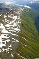
Most of the island is categorized as uplands. The heavily forested eastern coast reaches an elevation of 5,000 feet (1,500 meters). Valleys and lower slopes are covered by sand and gravel from glaciers. The southwestern part of the island, however, is essentially moist tundra, with its vegetation differing from the rest of the island.
A strong surface oceanic current, known as the Kuroshio, ensures warm, moist weather. Kodiak National Wildlife Refuge, established in 1941, covers approximately two-thirds of the island.
Kodiak Archipelago
Kodiak Island is part of the Kodiak Archipelago, (group of islands) south of the mainland of Alaska. It is about 252 miles (405 km) by air south of the city of Anchorage in the Gulf of Alaska.
Kodiak is the archipelago's largest island. To its north is the second largest island, Afognak, which has been extensively logged. Further north is Shuyak—an island of deep bays which is now in conservation. South of Kodiak are Tugidak and Sitkinak.
The archipelago is about 177 miles (285 km) long and 67 miles (108 km) across, from the Barren Islands on the north to Chirikof Island and the Semidi Islands group on the south. The archipelago contains 5,363 square miles (13,890 sq km) of land. There are about 40 small glaciers, numerous streams and hundreds of species of land and marine animals. Much of its land is forested.
The Kodiak Island Burough contains all of the Kodiak Archipelago and some lands on the mainland. The Kodiak National Wildlife Refuge encompasses a large percentage of the land in the archipelago.
Kodiak National Wildlife Refuge

The Kodiak National Wildlife Refuge is a wilderness area in the Kodiak Archipelago. The Refuge includes the southwestern two-thirds of Kodiak Island, Uganik Island, the Red Peaks area of Afognak Island and all of Ban Island in the archipelago. It encompasses about 3,000 square miles (7,700 sq km).
The refuge contains seven major rivers and about 100 streams. It is a spawning ground for all six species of Pacific Ocean salmon, trout and several other fish species, as well as a nesting ground for 250 species of bird, many of which feed on salmon.
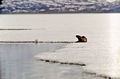
The refuge has only six native species of mammals: Kodiak brown bear, red fox, river otter, ermine, little brown bat and tundra vole. The non-native mammals Sitka deer, mountain goat, snowshoe hare and beaver were introduced to the archipelago between the 1920s and 1950s and are now hunted and trapped.
The climate of the refuge is that of southern Alaska, mild and rainy. Many areas in the refuge are densely forested with Sitka Spruce at lower elevations. There are grasslands in drier areas and at higher elevations. The refuge contains several small glaciers.
The refuge has no road access from outside and contains no roads.
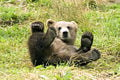
Kodiak Brown Bear
Emperor geese in Kodiak Wildlife Reserve
Otter on Karluk Lake, Kodiak Wildlife Reserve
Deglaciated mountains


Industry

The United States Coast Guard and its related entities are the largest employers on Kodiak Island, with 35 percent of the workforce involved. The seafood industry, including fish harvesting and seafood processing, is the next largest employment sector, with 27 percent.[3]
Coast Guard
The United States Coast Guard (USCG) is a branch of the United States military and one of seven uniformed services. It is unique among other armed forces in that it is a combination of a maritime law enforcement agency (with jurisdiction both domestically and in international waters), a military branch, and a federal regulatory agency. It is an agency of the United States Department of Homeland Security.
The Coast Guard's largest facility is in Kodiak. Between its operating and support commands, there are approximately 1,300 military and civilian personnel (government workers) and 1,700 military dependents on the island.
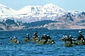
Fishing

The most productive fishing grounds in the world surround Kodiak Island, which serves as the "homeport" to more than 700 commercial fishing vessels. It is the state's largest fishing port, as well as home to some of Alaska's largest trawl, longline, and crab vessels. It is also consistently one of the top fishing ports in the United States both in terms of quantity and value.
The center of fishing activities for the Gulf of Alaska, its fishery is among the most diverse in the state, with at least 27 different fisheries not including the numerous groundfish fisheries (which are lumped together in a single category by the Commercial Fisheries Entry Commission).
The early nineteenth century saw the construction of the first salmon cannery in Karluk, built by the Russians. Salmon continues to be a mainstay of its fisheries.
In recent years, the groundfish fishery, primarily pollock and cod, has become increasingly important to Kodiak's economy. Alaska's Department of Fish and Game report the major fish catch to include: Alaska King Crab, Chinook Salmon, Chum Salmon, Coho Salmon, Dungeness Crab, Halibut, Pacific Herring, Pink Salmon, Rockfish, Scallop, Sockeye Salmon and Tanner Crabs.[4]
Notes
- ↑ 1.0 1.1 Kodiak Island Convention & Visitor's Bureau Cultural Time Periods of the Alutiiq Retrieved June 1, 2008.
- ↑ Encyclopædia Britannica Online, 2008, Kodiak Island Retrieved June 1, 2008.
- ↑ Kodiak Island Convention & Visitor's Bureau Labor Force Retrieved June 1, 2008.
- ↑ Kodiak Island Convention & Visitor's Bureau Seafood Industry Retrieved June 1, 2008.
ReferencesISBN links support NWE through referral fees
- Hrdlička, Aleš. 1944. The anthropology of Kodiak island. Philadelphia: Wistar Institute of anatomy and biology.
- Kodiak Island Convention & Visitor's Burea. Alaska's Emerald Isle Retrieved June 1, 2008.
- Molnia, Bruce. 1982. Alaska's glaciers. Alaska geographic, v. 9, no. 1. Anchorage, Alaska: Alaska Geographic Society. ISBN 9780882401676
- Mulcahy, Joanne B. 2001. Birth & rebirth on an Alaskan island: the life of an Alutiiq healer. Athens: University of Georgia Press. ISBN 9780820322537
External links
All links retrieved April 21, 2018.
Credits
New World Encyclopedia writers and editors rewrote and completed the Wikipedia article in accordance with New World Encyclopedia standards. This article abides by terms of the Creative Commons CC-by-sa 3.0 License (CC-by-sa), which may be used and disseminated with proper attribution. Credit is due under the terms of this license that can reference both the New World Encyclopedia contributors and the selfless volunteer contributors of the Wikimedia Foundation. To cite this article click here for a list of acceptable citing formats.The history of earlier contributions by wikipedians is accessible to researchers here:
- Kodiak_Island history
- Kodiak_Archipelago history
- Kodiak_National_Wildlife_Refuge history
- United_States_Coast_Guard history
The history of this article since it was imported to New World Encyclopedia:
Note: Some restrictions may apply to use of individual images which are separately licensed.