Chattahoochee-Oconee National Forest
The Chattahoochee-Oconee National Forest in northern Georgia comprises two National Forests, the Oconee National Forest and Chattahoochee National Forest. The Chattahoochee National Forest takes its name from the Chattahoochee River, whose headwaters begin in the North Georgia mountains. The river and the area were given the name by the English settlers who took the name from the Indians living here. The Cherokee and Creek inhabited North Georgia. In one dialect of the Muskogean languages, Chatta means stone; ho chee, marked or flowered. These marked or flowered stones were in the Chattahoochee River at a settlement near Columbus, Georgia.
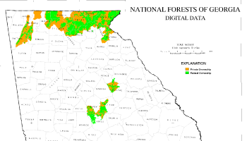
The combined total area of the Chattahoochee-Oconee National Forest is 865,855 acres (3,504 km²), of which the Chattahoochee National Forest comprises 750,502 acres (3,037 km²) and the Oconee National Forest comprises 115,353 acres (467 km²). The county with the largest portion of the forest is Rabun County, Georgia, which has 148,684 acres (601.7 km²) within its boundaries.
Geography
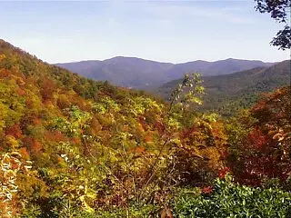
The mountainous Chattahoochee National Forest includes Brasstown Bald, Georgia's highest peak at 4,784 feet. Trails traverse the mountain and the observation deck offers breathtaking panoramic views of mountains and valleys. Unlike the tall peaks of the Chattahoochee, the Oconee National Forest is relatively flat with small hills.
History
In 1911, after the Weeks Act allowing the purchase of land east of the Mississippi River had passed Congress, the United States Forest Service purchased 31,000 acres (125 km²) of land denuded by hydraulic mining and logging from the Gennett family for $7 per acre. This land was the beginning of what would become the Chattahoochee National Forest. The initial land purchases became part of Cherokee National Forest on June 14, 1920.
Ranger Roscoe Nicholson, who was the first forest ranger in Georgia and had advised the Forest Service in its initial land purchases, continued the growth of the Chattahoochee by negotiating the purchase of most of the Forest Service land in what is now the Tallulah Ranger District. The Coleman River Scenic Area near Clayton, Georgia, was dedicated to "Ranger Nick", as he was called, in honor of his promotion of conservation ideals.
Ranger Arthur Woody also promoted conservation and was a key figure in the early development of the Chattahoochee. Unwise land and resource use had caused the deer and trout populations to virtually disappear in the North Georgia mountains, and Woody brought trout and deer back to the area. The trout were shipped to Gainesville, hauled across the narrow, dirt, mountain roads and eventually released in the streams. Woody also purchased fawns with his own money and fed them until they could be released on what became the Blue Ridge Wildlife Management Area. Many landmarks in the Chattoochee bear Ranger Woody’s name in tribute to his work. Sosebee Cove, a 175 acres (0.7 km²) tract of prize hardwood, is set aside as a memorial to Woody, who negotiated its purchase for the Forest Service.
On July 9, 1936, the Forest Service was reorganized to follow state boundaries and President Franklin D. Roosevelt proclaimed the Chattahoochee a separate National Forest. In 1936, the Chattahoochee was organized into two Ranger Districts, the Blue Ridge and the Tallulah.
In 1959, President Dwight D. Eisenhower proclaimed 96,000 acres (388 km²) of federal lands in central Georgia as the Oconee National Forest. The Oconee then joined the Chattahoochee to become the Chattahoochee-Oconee National Forests of today.
The Chattooga River was designated a Wild and Scenic River during the 1970s. The Chattooga remains one of the few free-flowing streams in the Southeast and is known for its white water rafting and beautiful scenery. The movie Deliverance was filmed on the Chattooga River.
Today
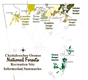
The Chattahoochee National Forest today covers 18 north Georgia counties. The Chattahoochee currently has five ranger districts, but two ranger districts, the Tallulah Ranger District and the Chattooga Ranger District will be combined.[1] It includes over 2,200 miles (3,500 km) of rivers and streams (including about 1,367 miles (2,200 km) of trout streams). There are over 450 miles (720 km) of hiking and other recreation trails, and 1,600 miles (2,600 km) of "roads." In addition to the Chattooga River and the headwaters of the Chattahoochee River, natural attractions within its boundaries include the beginning of the 2,174-mile (3,499 km) Appalachian Trail, Georgia's highpoint, Brasstown Bald, and Anna Ruby Falls.
The Chattahoochee also includes ten wildernesses that are part of the National Wilderness Preservation System. all of which are managed by the United States Forest Service. The wildernesses are:
- Big Frog Wilderness
- Blood Mountain Wilderness
- Brasstown Wilderness
- Cohutta Wilderness
- Ellicott Rock Wilderness
- Mark Trail Wilderness
- Raven Cliffs Wilderness
- Rich Mountain Wilderness
- Southern Nantahala Wilderness
- Tray Mountain Wilderness
The Oconee National Forest today is spread over eight Georgia counties and is organized into one ranger district. The Oconee Ranger District maintains several hiking and other recreational trails in the forest. Forest headquarters are located in Gainesville, Georgia.
Recreation
Wild rushing rivers, cascading waterfalls, ten wilderness areas, 1,367 miles of trout streams, and 430 miles of trails enrich the Chattahoochee National Forest. The 2,135-mile Appalachian Trail begins here.
Drive along the Ridge and Valley Scenic Byway, which tours the Armuchee Ridges of the Appalachian Mountains. Several major Civil War battles were fought in this area, most of them centered around the railroad, which stretched from Chattanooga, Tennessee to Atlanta, Georgia.
Across from the Armuchee Ridges lie the Blue Ridge Mountains. Lake Conasauga sits here, the States highest lake at more than 3,000 feet above sea level. This clear cool mountain lake is surrounded by white pines and eastern hemlocks.
Don't forget to stop at Brasstown Bald, Georgia's highest peak at 4,784 feet. Trails traverse the mountain and the observation deck offers breathtaking panoramic views of mountains and valleys.
Unlike the tall peaks of the Chattahoochee, the Oconee National Forest is relatively flat with small hills. Visit Lake Sinclair, 15,300 acres, popular for swimming, fishing, boating, and camping. Near Lake Oconee, an easy 1-mile trail leads to one of Georgia's ghost towns, Scull Shoals.
If a wealth of trails is the hallmark of the Chattahoochee, bountiful game is the signature of the Oconee. There are also plenty of excellent fishing opportunities.
The unique features of Georgia's national forests make these land a place of exploration and wonder. They are unique lands rich with recreation opportunities, history and spectacular scenery. Georgia Forests Recreation Opportunities Chattahoochee National Forest
Hiking and Riding: With over 430 miles of trails on the Chattahoochee, it's hard to find an area without some type of footpath! From short day hikes to more arduous trips, for novices or experts, there is a trail for every level, every purpose, The four long-distance trails on the Chattahoochee are great for backpacking: the Benton MacKaye (53 miles), Bartram (37 miles), Duncan Ridge (35.5 miles), and Appalachian (79 miles).
Water Recreation: The Chattooga Wild and Scenic River is most popular for guided rafting trips. This premier whitewater river offers some of the most challenging rapids in the Southeast. The Chattahoochee and Toccoa rivers are popular for canoe or kayak. Unlike most Georgia rivers, the Toccoa flows north instead of south, and is considered to be the state's loveliest river.
Fishing: Nearby Lake Blue Ridge is the only place in Georgia where anglers can catch muskellunge. This 3,290-acre lake is bordered by two Forest Service campgrounds and has a privately owned marina for boat rentals. Nottely Lake, Lake Chatuge, Lake Burton, and Lake Rabun also tough the Chattahoochee and provide good trout and bass fishing. With over 1,300 miles of trout streams on the forest, there are plenty opportunities to catch trout, walleye, bluegill, and bass.
Scenic Drives: The Ridge and Valley Scenic Byway is a 47-mile loop through the Armuchee Ridges. "Armuchee" is a Cherokee Indian work meaning :land of flowers," still an accurate description. John's Mountain Overlook has outstanding views reaching into Alabama and Tennessee. A nature trail from the overlook leads to Keown Falls Scenic Area, where twin waterfalls can be seen from an observation platform.
Spectacular fall colors bust in the trees along the Russell-Brasstown Scenic Byway. This 38-miles look has many interesting stops along the way. Dukes Creek Falls trail leads to the bottom of a gorge, where the air is cooled by the misty spray from the waterfalls. Several pools formed from the cold water tumbling down 250 feet provide a welcome relief for wary hikers.
Farther along the drive is the Raven Cliffs Trail, which twists for 2 ½ miles around several waterfalls, including one of the most unusual falls in the forest where water pours out of a crevice in a massive cliff about 90 feet high. Brasstown Bald is another popular stop on this drive.
Points of Interest: Brasstown Bald is the highest peak in Georgia. Shuttle vans carry most visitors from a parking lot to the top, but hardy hikers climb the path to the crest. Winds are always present on the lofty summit, which provides breathtaking views from the Visitor Center's observation deck.
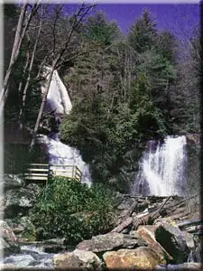
The cool, still hush of the surrounding lush forest is broken only by the thundering water of Anna Ruby Falls. This unique double waterfall cascades off of Tray Mountain in a spectacular 153-foot drop. The Lion's Eye Trail for the Blind adds a special dimension to one of Georgia's most visited spots.
Historic Sites: In the Northwest portion of the Chattahoochee, on the other side of Interstate 75, the mountain peaks are lower and shaped in long, narrow ridges, separated by valleys. These valleys have been used for centuries as human and animal passage ways. Great armies clashed here during the Civil Was as Union General William Tecumseh Sherman led his troops towards the fateful battle of Atlanta, which sealed the Confederacy's doom. Oconee National Forest
Hiking and Riding: Hiking trails are near major recreation areas. Three trails are suitable for horseback riding near the Ocmulgee River. The 1-mile Burgess Mountain Trail reaches the highest point on the forest at 645 feet above sea level, and is open to horseback riding.
Water Recreation: Lake Sinclair is a popular lake for swimming, fishing, and boating. The Oconee River is an excellent canoeing river, with the Oconee River Campground the favorite launching point.
Fishing: Spring catches of red-breast sunfish, particularly in the Ocmulgee River, are considered exceptional. Lake Oconee is well Known for its crappie and other fish.
Historic Sites: The site of Georgia's fist cotton gin an paper mill, Scull Shoals is crumbling ghost town near lake Oconee. Tumbling walls and other ruins still stand amidst the lush forest and quiet waters. A short trail nearby leads to two prehistoric Indian mounds.
Georgia counties
Listed below are the counties with land in the Forest showing the area and the relevant ranger districts.[2]
Chattahoochee National Forest
Chattooga Ranger District
- Banks County, 650 acres (2.6 km²)
- Stephens County, 23,304 acres (94 km²)
- Habersham County, 39,874 acres (161 km²)
- White County, 41,316 acres (167 km²)
Armuchee-Cohutta Ranger District
- Catoosa County, 6 acres (0.02 km²)
- Chattooga County, 19,390 acres (78 km²)
- Gordon County, 8,076 acres (33 km²)
- Floyd County, 6,620 acres (27 km²)
- Murray County, 51,696 acres (209 km²)
- Walker County, 18,844 acres (76 km²)
- Whitfield County, 11,719 acres (47 km²)
Toccoa Ranger District
- Dawson County, 6,760 acres (27 km²)
Tallulah Ranger District
- Rabun County, 148,684 acres (602 km²)
Armuchee-Cohutta and Toccoa Districts
- Fannin County, 106,130 acres (429 km²), Armuchee-Cohutta and Toccoa Districts
- Gilmer County, 55,074 acres (223 km²), Armuchee-Cohutta and Toccoa Districts
Brasstown, Chattooga, and Toccoa Districts
- Lumpkin County, 56,982 acres (231 km²), Brasstown, Chattooga, and Toccoa districts
- Towns County, 57,538 acres (233 km²), Brasstown, Chattooga, and Tallulah Districts
- Union County, 97,839 acres (396 km²), Brasstown, Chattooga, and Toccoa districts
Oconee National Forest
The Oconee National Forest is almost halfway between Macon and Athens. There are several man-made lakes in the region that are available for public watercraft. Hiking and camping are encouraged, but there are some places in the forest that are considered private land. Galingayle, a master planned community in Madison, is an example of some of the private land that is not available to outsiders unless they are with a member. These communities work with park rangers to ensure that their lifestyle has little or no impact on the environment.
Oconee Ranger District
- Greene County, 26,659 acres (108 km²)
- Jasper County, 30,312 acres (123 km²)
- Jones County, 16,461 acres (67 km²)
- Monroe County, 251 acres (1.0 km²)
- Morgan County, 308 acres (1.2 km²)
- Oconee County, 157 acres (0.6 km²)
- Oglethorpe County, 3,762 acres (15 km²)
- Putnam County, 37,443 acres (152 km²)
Looking to the future
Atlanta's urban sprawl is already touching the southern part of the forest. Other threats include the acid rain that falls during the summer due to air pollution. The road-building that occurred to allow logging companies access to the forest has damaged sensitive areas, and some land is now being redesignated as roadless. Southern pine beetle infestations are on the rise, destroying wildlife habitat.
Illegal use of all-terrain vehicles is causing damage as well. By creating trenches or trails on hillsides, these vehicles cause soil erosion, which leads to sediment in streams. This in turn affects water quality as well as the health of fish and other life in the water. Mud-bogging by ATV riders has also caused serious damage to many wetland areas.
On the positive side, state, county, and local governments, along with private citizens, are adding to the acreage that is protected through purchases and donations.
ReferencesISBN links support NWE through referral fees
External links
- Chattahoochee-Oconee National Forest
- History of Chattahoohee National Forest
- Trails of the Chattahoochee-Oconee National Forest
Credits
New World Encyclopedia writers and editors rewrote and completed the Wikipedia article in accordance with New World Encyclopedia standards. This article abides by terms of the Creative Commons CC-by-sa 3.0 License (CC-by-sa), which may be used and disseminated with proper attribution. Credit is due under the terms of this license that can reference both the New World Encyclopedia contributors and the selfless volunteer contributors of the Wikimedia Foundation. To cite this article click here for a list of acceptable citing formats.The history of earlier contributions by wikipedians is accessible to researchers here:
The history of this article since it was imported to New World Encyclopedia:
Note: Some restrictions may apply to use of individual images which are separately licensed.


