Andes
- This article is about the mountain system in South America. For other uses of the term, see Andes (disambiguation).
| Andes (Quechua: Anti(s)) | |||
|---|---|---|---|
 | |||
| Countries | Argentina, Bolivia, Chile, Colombia, Ecuador, Peru, Venezuela | ||
| Major cities | La Paz, Quito, Cusco, Bogotá | ||
| Length | 7,000 km (4,350 miles) | ||
| Width | 500 km (311 miles) | ||
| Highest point | Aconcagua | ||
| - coordinates | coord}}{{#coordinates:32|39|10|S|70|0|40|W|landmark | name=
}} | |
| - elevation | 6,962 meters (22,841 feet) | ||

The Andes (Quechua: Anti(s)) is South America's longest mountain range[1], forming a continuous chain of highland along the western coast of South America. It is over 7,000 km (4,400 miles) long, 500 km (300 miles) wide in some parts (widest between 18° to 20°S latitude), and of an average height of about 4,000 m (13,000 feet).
The Andean range is composed principally of two great ranges, the Cordillera Oriental and the Cordillera Occidental, often separated by a deep intermediate depression, in which arise other chains of minor importance, the chief of which is Chile's Cordillera de la Costa. Other small chains arise on the sides of the great chains. The Cordillera de la Costa starts from the southern extremity of the continent and runs in a northerly direction, parallel with the coast, being broken up at its beginning into a number of islands and afterwards forming the western boundary of the great central valley of Chile. To the north this coastal chain continues in small ridges or isolated hills along the Pacific Ocean as far as Venezuela, always leaving the same valley more or less visible to the west of the western great chain. The mountains extend over seven countries: Argentina, Bolivia, Chile, Colombia, Ecuador, Peru and Venezuela, some of which are known as Andean States. One theory says the name Andes comes from the Quechua word anti, which means "high crest." Another theory says that the name Andes derived from the Spanish word "anden" which means terrace in reference to the cultivation terraces used by the Incas and other related peoples.
The Andes mountain range is the highest mountain range outside Asia, with the highest peak, Aconcagua, rising to 6,962 m (22,841 feet) above sea level. The summit of Mount Chimborazo in the Ecuadorean Andes is the point on the Earth's surface most distant from its center, because of the equatorial bulge. The Andes cannot match the Himalayas in height but do so in width and are more than twice as long.
Physical features
Geology

The Andes fundamentally are the result of plate tectonics processes, caused by the subduction of the Nazca plate beneath the South American plate. The boundary between the two plates is marked by the Peru-Chile oceanic trench. The descending Nazca plate is young and buoyant lithosphere, which resists subduction, causing a lot of earthquakes. The formation of the Andes began in the Jurassic period. It was during the Cretaceous Period that the Andes began to take their present form, by the uplifting, faulting and folding of sedimentary and metamorphic rocks of the ancient cratons to the east. Tectonic forces along the subduction zone along the entire west coast of South America where the Nazca Plate and a part of the Antarctic Plate are sliding beneath the South American Plate continue to produce an ongoing orogenic event resulting in minor to major earthquakes and volcanic eruptions to this day. In the extreme south a major transform fault separates Tierra del Fuego from the small Scotia Plate. Across the 1,000 km wide Drake Passage lie the mountains of the Antarctic Peninsula south of the Scotia Plate which appear to be a continuation of the Andes chain.
The Andes range has many active volcanoes, including Cotopaxi, one of the highest active volcanoes in the world.
The Andes can be divided into three sections: the Southern Andes in Argentina and Chile; the Central Andes, including the Chilean and Peruvian cordilleras; and the northern section in Venezuela, Colombia, and northern Ecuador consisting of two parallel ranges, the Cordillera Occidental and the Cordillera Oriental. The term cordillera comes from the Spanish word meaning 'rope'. The Andes range is approximately 200–300 km wide throughout its length, except in the Bolivian flexure where it is 640 km wide. The islands of Aruba, Bonaire, and Curaçao, which lie in the Caribbean Sea off the coast of Venezuela, represent the submerged peaks of the extreme northern edge of the Andes range.
Climate

The climate in the Andes varies greatly depending on location, altitude, and proximity to the sea. The southern section is rainy and cool, the central Andes are dry. The northern Andes are typically rainy and warm, with an average temperature of 18 °C in Colombia. The climate is known to change drastically. Tropical rainforests exist just miles away from the snow covered peak, Cotopaxi. The mountains have a large effect on the temperatures of nearby areas. The snow line depends on the location. It is at between 4,500–4,800 m in the tropical Ecuadorian, Colombian, Venezuelan, and northern Peruvian Andes, rising to 4,800–5,200 m in the drier mountains of southern Peru south to northern Chile south to about 30°S, then descending to 4,500 m on Aconcagua at 32°S, 2,000 m at 40°S, 500 m at 50°S, and only 300 m in Tierra del Fuego at 55°S; from 50°S, several of the larger glaciers descend to sea level (Google Earth/World Wind images).
Plant and animal life
Tropical rainforests and rainforests encircle the northern Andes. The cinchona, a source of quinine which is used to treat malaria, is found in the Bolivian Andes. The high-altitude Polylepis forests are present in the Andean areas of Ecuador, Peru and Bolivia. The trees, Queñua, Yagual and other names that local people use to call them, can be found at altitudes of 4, 500 m above sea level. Once abundant, the forests began disappearing during the Incan period when much of it was used for building material and cooking fuel. The trees are now considered to be highly endangered with only 10% of the original forests remaining [1].
The llama can be found living at high altitudes, predominantly in the Peru and Bolivia. The alpaca, a type of llama, is raised for its wool. The nocturnal chinchilla, an endangered member of the rodent order, inhabits the Andes' alpine regions. The South American condor is the largest bird of its kind in the Western hemisphere. Other animals include the huemul, cougar, camelids and, for birds, the partridge, parina, huallata, and coot. Llamas and cougars play important roles in many Andean cultures.
The people


The Inca Empire developed in the northern Andes during the 1400s. The Incas formed this civilization through careful and meticulous governmental management. The government sponsored the construction of aqueducts and roads, some of which, like those created by the Romans, are still in existence today. The aqueducts turned the previously scattered Incan tribe into the agricultural and eventually militaristic masters of the region.
Devastated by deadly European diseases to which they had no immunity, the Incas were conquered by an army of 180 men led by Pizarro in 1532. One of the few Inca cities the Spanish never found in their conquest was Machu Picchu, which lay hidden on a peak on the edge of the Andes where they descend to the Amazon. The main surviving languages of the Andean peoples are those of the Quechua and Aymara language families.
Mountaineering/Surveying
Woodbine Parish and Joseph Barclay Pentland surveyed a large part of the Bolivian Andes from 1826 to 1827.
Transportation
The people of the Andes are not well connected to urban regions. Due to the arduous terrain, vehicles are of little use. People generally walk to their destinations, using the llama as their primary pack animal.
Agriculture
The ancient peoples of the Andes such as the Incas have practiced irrigation techniques for over 6,000 years. Because of the mountain slopes, terracing has been a common practice. Maize and barley were important crops for these people. Currently, tobacco, cotton and coffee are the main export crops. The potato holds a very important role as an internally consumed crop.
By far the most important plant in terms of history and culture is coca, the leaves of which have been central to the Andean people for centuries. Coca has been a staple dietary supplement and cornerstone to Andean culture throughout much of its history.
Mining
Mining is quite prosperous in the Andes, with iron, gold, silver and copper being the main production minerals. The Andes are reputed to be one of the most important sources of these minerals in the world.
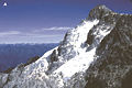
Peaks
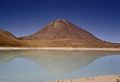
Licancabur, Bolivia/Chile
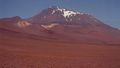
Llullaillaco, Chile/Argentina
- Aconcagua - Argentina - January 2005 - by Sergio Schmiegelow.jpg
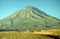
Aconcagua, Argentina
Chimborazo, Ecuador
Alpamayo, Peru
El Misti, Peru
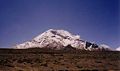
Pico Bolívar, Venezuela
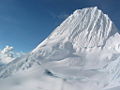
- Humboldt-peak.jpg
Pico Humboldt, Venezuela


Argentina
- See also List of mountains in Argentina
- Aconcagua, 6,962 m
- Cerro Bonete, 6,759 m (not 6,872 m)
- Galán, 5,912 m (not 6,600 m)
- Mercedario, 6,720 m
- Pissis, 6,795 m (not 6,882 m)
Argentina/Chile border
- Cerro Bayo, 5,401 m
- Cerro Chaltén, 3,375 m or 3,405 m, Patagonia, also known as Cerro Fitz Roy
- Cerro Escorial, 5,447 m
- Cordón del Azufre, 5,463 m
- Falso Azufre, 5,890 m
- Incahuasi, 6,620 m
- Lastarria, 5,697 m
- Llullaillaco, 6,739 m
- Maipo, 5,264 m
- Marmolejo, 6110 m
- Ojos del Salado, 6,893 m
- Olca, 5,407 m
- Sierra Nevada de Lagunas Bravas, 6,127 m
- Socompa, 6,051 m
- Nevado Tres Cruces, 6,749 m (south summit) (III Region)
- Tupungato, 6,570 m
Bolivia
- Ancohuma, 6,427 m
- Cabaray, 5,860 m
- Chacaltaya, 5,421 m
- Huayna Potosí, 6,088 m
- Illampu, 6,368 m
- Illimani, 6,438 m
- Macizo de Larancagua, 5,520 m
- Macizo de Pacuni, 5,400 m
- Nevado Anallajsi, 5,750 m
- Nevado Sajama, 6,542 m
- Patilla Pata, 5,300 m
- Tata Sabaya, 5,430 m
Bolivia/Chile border
- Acotango, 6,052 m
- Cerro Minchincha, 5,305 m
- Irruputuncu, 5,163 m
- Licancabur, 5,920 m (there is no "6,620 m Lincancaur" in Argentina)
- Olca, 5,407 m
- Parinacota, 6,348 m
- Paruma, 5,420 m
- Pomerape, 6,282 m
Chile
- See also List of mountains in Chile
- Monte San Valentin, 4,058 m (Patagonia)
- Cerro Paine Grande, c. 2,750 m (Patagonia) (not 3,050 m)
- Cerro Macá, c.2300 m (Patagonia) (not 3,050 m)
- Monte Darwin, c.2500 m (Patagonia)
- Volcan Hudson, c.1900 m (Patagonia)
- Cerro Castillo Dynevor, c.1100 m (Patagonia)
- Mount Tarn, c.825 m (Patagonia)
Colombia
- Galeras, 4,276 m
- Nevado del Huila, 5,365 m
- Nevado del Ruiz, 5,321 m
- Ritacuba Blanco, 5,410 m
- Snow Mountain of Quindio, 5,215 m
Ecuador
- Antisana, 5,753 m
- Cayambe, 5,790 m
- Chimborazo, 6,267 m
- Corazón, 4,790 m
- Cotopaxi, 5,897 m
- El Altar, 5,320 m
- Illiniza, 5,248 m
- Pichincha, 4,784 m
- Quilotoa, 3,914 m
- Reventador, 3,562 m
- Sangay, 5,230 m
- Tungurahua, 5,023 m
Peru
- Alpamayo, 5,947 m
- Carnicero, 5,960 m
- El Misti, 5,822 m
- El Toro, 5,830 m
- Huascarán, 6,768 m
- Jirishanca, 6,094 m
- Pumasillo, 5,991 m
- Rasac, 6,040 m
- Rondoy, 5,870 m
- Sarapo, 6,127 m
- Seria Norte, 5,860 m
- Siula Grande, 6,344 m
- Yerupaja, 6,635 m
- Yerupaja Chico, 6,089 m
Venezuela
- Pico Bolívar, 4,981 m
- Pico Humboldt, 4,940 m
- Pico La Concha, 4,870 m
- Pico Piedras Blancas, 4,740 m
ReferencesISBN links support NWE through referral fees
- ↑ The world's longest mountain range is ocean ridge, with a total length of over 80,000 km
- John Biggar, The Andes: A Guide For Climbers, 3rd. edition, 2005, ISBN 0-9536087-2-7
- Tui de Roy, The Andes: As the Condor Flies. 2005, ISBN 1-55407-070-8
External links
- PhotoGlobe: Andes around Mt. Mercedario
- Andes geology (University of Arizona)
- Climate and animal life of the Andes
- Civilizations of Ancient Peru
- Complete list of separate mountains in the Andes over 6000 m
- [2]
- Famous Andes peaks
- http://www.peaklist.org/WWlists/ultras/southamerica.html Complete list of mountains in South America with a prominence of at least 1500 m
Credits
New World Encyclopedia writers and editors rewrote and completed the Wikipedia article in accordance with New World Encyclopedia standards. This article abides by terms of the Creative Commons CC-by-sa 3.0 License (CC-by-sa), which may be used and disseminated with proper attribution. Credit is due under the terms of this license that can reference both the New World Encyclopedia contributors and the selfless volunteer contributors of the Wikimedia Foundation. To cite this article click here for a list of acceptable citing formats.The history of earlier contributions by wikipedians is accessible to researchers here:
The history of this article since it was imported to New World Encyclopedia:
Note: Some restrictions may apply to use of individual images which are separately licensed.