United States National Lakeshore

A National Lakeshore is a protected area of lakeshore in the United States. National Lakeshores are similar to U.S. National Parks in that they are maintained and protected by the National Park Service.
In 2008 there were four National Lakeshore areas in the United States, all of them on Lakes Michigan and Superior in the states of Michigan, Indiana, and Wisconsin. The combined area of the four protected areas is 145,641 acres (589.3 km²) and includes:
- Pictured Rocks National Lakeshore, near Munising, Michigan, on Lake Superior. Authorized in 1966, Pictured Rocks was the first National Lakeshore and largest by area.
- Indiana Dunes National Lakeshore, in northwest Indiana, near Michigan City, on Lake Michigan. Authorized in 1966, soon after Pictured Rocks. By most estimates, this park is the most popular National Lakeshore, probably due to its proximity to Chicago and other large Midwestern cities.
- Apostle Islands National Lakeshore, in northern Wisconsin on Lake Superior. Authorized in September 1970.
- Sleeping Bear Dunes National Lakeshore, in Leelanau County Michigan, on Lake Michigan. Authorized in October 1970.
History
National lakeshores are part of a system of United States coastlines administered by the National Park Service and preserved for their scenic, recreational, and habitat resources. The national lakeshore system is an extension of the national seashores system established in the 1930s to preserve the nation's dwindling patches of publicly-owned coastline on the Atlantic, Pacific, and Gulf coasts. Since before 1930 the movement to preserve both seashores and lakeshores has been a conservationist response to the rapid privatization of coastlines by industrial interests and private home owners. In 1992 the United States had four designated National Lakeshores: Indiana Dunes on the southern tip of Lake Michigan, Sleeping Bear Dunes on Lake Michigan's eastern shore, and the Apostle Islands and Pictured Rocks, both on Lake Superior's southern shore.
Attention focused on disappearing Great Lakes shorelines, sometimes called the United States' "fourth coastline," as midwestern development pressures increased after World War II. During the 1950s lakeshore industrial sites became especially valuable with the impending opening of the St. Lawrence Seaway. The seaway, giving landlocked lake ports access to Atlantic trade from Europe and Asia, promised to boost midwestern industry considerably. Facing this threat to remaining wild lands, the National Park Service conducted a survey in 1957-58, attempting to identify and catalog the Great Lakes' remaining natural shoreline. The survey produced a list of 66 sites qualified for preservation as natural, scenic, or recreational areas. Of these, five sites were submitted to Congress in the spring of 1959.
The Indiana Dunes site was a spearhead for the movement to designate national lakeshores. Of all the proposed preserves, this one was immediately threatened in the 1950s and 1960s by northern Indiana's expanding steel industries. Residents of neighboring Gary were eager for jobs and industrial development, but conservationists and politicians of nearby Chicago argued that most of the lake was already developed and lobbied intensely for preservation. The Indiana Dunes provided a rare patch of undeveloped acreage that residents of nearby cities valued for recreation. Equally important, the dunes and their intradunal ponds, grasslands, and mixed deciduous forests provided habitat for animals and migratory birds, most of whose former range already held the industrial complexes of Gary and Chicago. In addition, the dunes harbored patches of relict boreal habitat left over from the last ice age. After years of debate, the Indiana Dunes and Great Sleeping Bear Dunes National Lakeshores were established in 1966, with the remaining two lakeshores designated four years later.
The other three national lakeshores are less threatened by industrial development than Indiana Dunes, but they preserve important scenic and historic resources.
Pictured Rocks National Lakeshore


Pictured Rocks National Lakeshore is a U.S. National Lakeshore on the shore of Lake Superior in the Upper Peninsula of Michigan. It extends for 42 miles (67 km) along the shore and covers 73,236 acres (114 sq mi/296 km2). The park offers spectacular scenery of the hilly shoreline between Munising, Michigan and Grand Marais, Michigan, with natural archways, waterfalls, and sand dunes.
Pictured Rocks derives its name from the 15 miles (24 km) of colorful sandstone cliffs northeast of Munising. The cliffs are up to 200 feet (60 m) above lake level. They have been naturally sculptured into shallow caves, arches, formations that resemble castle turrets, and human profiles, among others. Near Munising visitors also can view Grand Island, most of which is included in the Grand Island National Recreation Area and is preserved separately.
The U.S. Congress made Pictured Rocks the first officially-designated National Lakeshore in the United States in 1966. It is governed by the National Park Service, and receives approximately half a million visitors per year.
History
Although the Pictured Rocks lie adjacent to sections of Lake Superior that are rich in fish, the sandstone cliffs are dangerous to canoes and other open boats skirting the coastline. Pierre Esprit Radisson, the fur trader, made this risky passage in 1658 and noted that his Native American companions offered some tobacco to the local spirit of the cliffs.
During the Romantic Era of the 1800s, a series of American writers described their feelings upon sight of the Pictured Rocks. Henry Rowe Schoolcraft paid a tribute in 1820 to "some of the most sublime and commanding views in nature." As long ago as 1850 developers platted a tourist resort, Grand Island City, adjacent to the Pictured Rocks near the current site of Munising.
After the lumbering era ended around 1910, many of the parcels of land making up the current Pictured Rocks National Lakeshore reverted to the state of Michigan for unpaid property taxes. Eager for federal help and recognition, the state cooperated with the federal government in the region's redevelopment.
On October 15 1966, Congress passed a bill (Public Law 89-668) authorizing the establishment of the Pictured Rocks National Lakeshore in Michigan's Upper Peninsula, "in order to preserve for the benefit, inspiration, education, recreational use, and enjoyment of the public, a significant portion of the diminishing shoreline of the United States and its related geographic and scientific features." When President Lyndon Johnson signed the bill, Alger County became the home of America’s first National Lakeshore.[1]
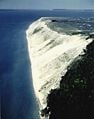
Grand Sable Dunes
The Grand Sable Dunes, at the eastern end of the Lakeshore, are a perched dune formation. Sand washed ashore by wave action was then blown upslope by northerly prevailing winds until it came to rest atop a glacial moraine. The Grand Sable Dunes today form a sand slope that rises from Lake Superior at a 35° angle. The summits of the tallest dunes are as high as 275 feet (85 m) above lake level.
Pictured Rocks National Lakeshore Photo Gallery
Looking down at the Miners' Castle. November 2004.
Miners' Castle.
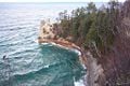
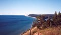
Pictured Rocks in the distance.
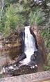
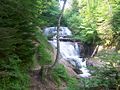
Miners Falls
Miners Falls
Grand Sable Dunes
Grand Sable Dunes
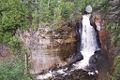
Sable Falls


Indiana Dunes National Lakeshore

Indiana Dunes National Lakeshore is a national lakeshore located in northwest Indiana that was authorized by Congress in 1966. The national lakeshore runs for 15 miles (40 km) along the southern shore of Lake Michigan, from Gary, Indiana, on the west to Michigan City, Indiana on the east. The park contains approximately 15,000 acres (61 km²). While the National Lakeshore has development rights over the area within its boundaries, it has not purchased the full extent of the property. Its holdings are non-contiguous and do not include the Indiana Dunes State Park (1916), a separate, 2,182 acre (9 km²) parcel of protected dune land on the lakefront near Chesterton, Indiana.
The park contains 15 miles (24 km) of beaches, as well as sand dunes, bogs, marshes, swamps, fens, prairies, rivers, oak savannas, and woodland forests. The park is also noted for its singing sands. More than 350 species of birds have been observed in the park. It has one of the most diverse plant communities of any unit in the U.S. National Park System with 1418 vascular plant species including 90 threatened or endangered ones. The Indiana Dunes area is unique in that it contains both Arctic and boreal plants (such as the bearberry) alongside desert plants (such as the prickly pear cactus).
Indiana Dunes National Lakeshore is full of wildlife, including whitetail deer, red fox, raccoons, oppossums, cottontail rabbits, Canada geese, seagulls, squirrels, hawks, turkey vultures, mallards, great blue herons, garter snakes, songbirds, and rodents.
Lakeshore history

The Indiana Dunes area first came to prominence in 1899 when Henry Chandler Cowles did some of the pioneering work in American plant ecology there. Despite attempts to protect the area from threats such as the nearby Gary steel mills led by groups such as the Prairie Club of Chicago, the area continued to be exploited. The tallest dune in Indiana, the 200 foot (60 m) high Hoosier Slide, was hauled away and turned into glass by Pittsburgh Plate Glass and canning jars by Ball Brothers.
In 1916 there was talk of making the site the "Sand Dunes National Park". Indiana State Park's founder Richard Lieber toured the site with then NPS Director Stephen Mather on October 31, 1916 to gauge its worthiness.[2] In 1926, part of the area became the Indiana Dunes State Park. A few years later, the Indiana Dunes Bathhouse and Pavilion was erected just north of the park entrance. The bathhouse continues to be widely used today and remains in its original form.
Significant political controversy arose in the 1950s and 1960s due to conflicts between industrial expansion and recreational use of the lakefront. One event heavily protested was the removal of a sand dune to provide landfill for the expansion of Northwestern University's Evanston, Illinois campus.[3][4]. Bethlehem Steel was additionally granted permits to build a plant at Burns Harbor Indiana, displacing dunes and wildlife.
Citizens united to form the Save the Dunes Council and gained political support to protect the remaining lakeshore. In 1963, the Kennedy Compromise linked the construction of the Port of Indiana to the development of a National Lakeshore. The Lakeshore was created in 1966 and expanded in 1976, 1980, 1986 and 1992. [5]
Apostle Islands National Lakeshore


EDIT: Wisconsin's Apostle Islands, a chain of 22 glacier-scarred, rocky islands, bear evidence of perhaps 12,000 years of human habitation and activity. However most of the historic relics date from the nineteenth century, when loggers, miners, and sailors left their mark. In this area the coniferous boreal forest of Canada meets the deciduous Midwestern forests, producing an unusual mixture of sugar maple, hemlock, white cedar, and black spruce forests. Nearly 20 species of orchids find refuge in these islands. Pictured Rocks National Lakeshore preserves extensive historic navigation relics, including sunken ships, along with its scenic and recreational resources.
The Apostle Islands National Lakeshore is a national lakeshore consisting of twenty two islands, known as the Apostle Islands, and shoreline encompassing 69,372 acres (281 km²) off the Bayfield Peninsula in northern Wisconsin on the shore of Lake Superior. It is known for its collection of historic lighthouses, sandstone sea caves, a few old growth remnant forests, and natural animal habitats.
The Apostle Islands are a result of the glaciers that once covered North America. "Geologically they are originally part of the main land at the edge of the great riff or fault which formed the depression to which the waters of Lake Superior collected."[6] When the glaciers melted the remnant water began to shape the islands. Over time, the waves from the waters of Lake Superior caused erosion that formed the islands. Due to the glacial shift, the islands are composed of mostly red sandstone.
In the 1600s, Wisconsin was inhabited by Algonquian tribes, the Menominee and others. They were joined by Siouan tribes, including the Winnebago and Iowa. Later groups included the Potawatomi and Chippewa (Ojibwa). It is believed that French explorer Etienne Brule visited the area in the early 1600s. The first non-Natives to settle the area were fur traders. It is believed that the islands were named by 17th-century Jesuit missionaries for the Twelve Apostles.
United States Senator Gaylord Nelson fought long and hard for the protection of the area and sponsored the federal legislation that established the Apostle Islands National Lakeshore. On December 8, 2004, President George W. Bush honored Nelson by approving legislation designating 80 percent of the land area of Apostle Islands National Lakeshore as federally protected wilderness - to be known as Gaylord Nelson Wilderness.[7]
Lighthouses
One of the most popular sights within the lakeshore are the Apostle Islands Lighthouses. These are a group of six lighthouses, located in the Apostle Islands. For most of the century, these lighthouses have guided ships and boats through the rough waters of Lake Superior, and among the Apostle Islands. In 1977 they were listed in the National Register of Historic Places.
Lighthouses included in the historic registry:
- Michigan Island Lighthouse - two lighthouses located at this site
- Raspberry Island Lighthouse
- Outer Island Lighthouse
- Sand Island Light
- Devils Island Lighthouse
Sleeping Bear Dunes National Lakeshore
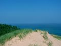
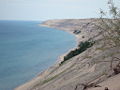
EDIT: Sleeping Bear Dunes contains some of Michigan's sandy pine forests as well as arid land forbs, grasses, and sedges that are rare in the rest of the Midwest. Two prized aspects of this national lakeshore are its spectacular bluffs and active dunes, some standing hundreds of feet high along the edge of Lake Michigan.
Sleeping Bear Dunes National Lakeshore is a United States National Lakeshore located along the northwest coast of the Lower Peninsula of Michigan in Leelanau and Benzie Counties.

The park covers a 35 mile (60 km) stretch of Lake Michigan's eastern coastline, as well as North and South Manitou Islands. The park was established primarily for its outstanding natural features, including forests, beaches, dune formations, and ancient glacial phenomena. The Lakeshore also contains many cultural features including the 1871 South Manitou Island Lighthouse, three former Life-Saving Service/Coast Guard Stations and an extensive rural historic farm district. The park was authorized on October 21, 1970.
The park is named after a Chippewa legend of the sleeping bear. According to the legend, an enormous forest fire on the western shore of Lake Michigan drove a mother bear and her two cubs into the lake for shelter, determined to reach the opposite shore. After many miles of swimming, the two cubs lagged behind. When the mother bear reached the shore, she waited on the top of a high bluff. The exhausted cubs drowned in the lake, but the mother bear stayed and waited in hopes that her cubs would finally appear. Impressed by the mother bear's determination and faith, the Great Spirit created two islands (North and South Manitou Island) to commemorate the cubs, and the winds buried the sleeping bear under the sands of the dunes where she waits to this day. The "bear" was a small tree-covered knoll at the top edge of the bluff that, from the water, had the appearance of a sleeping bear. Wind and erosion have caused the "bear" to be greatly reduced in size over the years. Today only a small remnant remains.
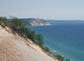
Looking south from Sleeping Bear Dunes
Sleeping Bear Dunes and South Manitou Island from Empire Bluff
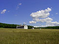
Historic D.H. Day Farm
Aerial View of Sleeping Bear Dunes


Notes
- ↑ National Park Service. Pictured Rocks, an Administrative History: Chapter 3, The Creation of Pictured Rocks National Lakeshore Retrieved January 11, 2009.
- ↑ National Park Service. NPS Historic Photograph Collection Retrieved January 11, 2009.
- ↑ Northwestern University. Looking for space, University turned eastward to the lake Retrieved January 11, 2009.
- ↑ Chicago Historical Society. Statement of U.S. Senator Paul H. Douglas regarding Indiana Dunes, 1962 Retrieved January 11, 2009.
- ↑ J. Ronald Engel. 1983. Sacred Sands, The Struggle for Community in the Indiana Dunes. Middletown, Connecticut: Wesleyan University Press.
- ↑ Hamilton N. Ross. 1951. The Apostle Islands. 2nd ed. Batavia, NY: Batavia Herald.
- ↑ National Park Service. Apostle Islands National Lakeshore - Gaylord Nelson Wilderness Retrieved January 11, 2009.
ReferencesISBN links support NWE through referral fees
- Franklin, Kay, and Norma Schaeffer. 1983. Duel for the dunes: land use conflict on the shores of Lake Michigan. Urbana: University of Illinois Press. ISBN 9780252010347
- Hill, Catherine L. 1991. Our changing landscape: Indiana Dunes National Lakeshore. US Geological Survey circular, 1085. Washington, DC: U.S. Gov. Print. Off. OCLC 257242912
- National Park Service. Pictured Rocks National Lakeshore Retrieved January 11, 2009.
- National Park Service. Indiana Dunes National Lakeshore Retrieved January 11, 2009.
- National Park Service. Apostle Islands National Lakeshore Retrieved January 11, 2009.
- National Park Service. Sleeping Bear Dunes National Lakeshore Retrieved January 11, 2009.
- United States. 1988. Apostle Islands: a guide to Apostle Islands National Lakeshore, Wisconsin. Washington, D.C.: U.S. Dept. of the Interior. OCLC 16473846
- United States. 1992. Sleeping Bear Dunes National Lakeshore: Pierce Stocking Scenic Drive. [Washington, D.C.?]: National Park Service, Dept. of the Interior. OCLC 26366804
Credits
New World Encyclopedia writers and editors rewrote and completed the Wikipedia article in accordance with New World Encyclopedia standards. This article abides by terms of the Creative Commons CC-by-sa 3.0 License (CC-by-sa), which may be used and disseminated with proper attribution. Credit is due under the terms of this license that can reference both the New World Encyclopedia contributors and the selfless volunteer contributors of the Wikimedia Foundation. To cite this article click here for a list of acceptable citing formats.The history of earlier contributions by wikipedians is accessible to researchers here:
- United_States_National_Lakeshore history
- Pictured_Rocks_National_Lakeshore history
- Apostle_Islands_National_Lakeshore history
- Sleeping_Bear_Dunes_National_Lakeshore history
- Indiana_Dunes_National_Lakeshore history
The history of this article since it was imported to New World Encyclopedia:
Note: Some restrictions may apply to use of individual images which are separately licensed.