Tokelau
- For other uses, see Tokelau (disambiguation).
| ||||||||||||||||||||||||||||||||||||||||||||||
Tokelau is a non-self-governing colonial territory of New Zealand that comprises a group of three tropical coral atolls in the South Pacific Ocean. The islands are occasionally referred to by an older colonial name, The Union Islands, and until 1976 the official name was Tokelau Islands. The United Nations Committee on Decolonization includes Tokelau on the United Nations list of Non-Self-Governing Territories.
History
Tokelau was originally settled by Polynesians migrating from other island groups. The islands became a British protectorate in 1889 and then were annexed to the British colony of the Gilbert and Ellice Islands in 1916 and then transferred to New Zealand administration in 1926. By the Tokelau Act of 1948 sovereignty over Tokelau was transferred to New Zealand. Defence is also the responsibility of New Zealand. However, the Tokelauans are drafting a constitution and developing institutions and patterns of self-government as Tokelau moves towards free association with New Zealand, similarly to Niue and the Cook Islands.
Politics
The head of state is Queen Elizabeth II, who is represented by Administrator Neil Walter. The head of government is Pio Tuia, who presides over the Council of Faipule, consisting of three elected leaders, one from each atoll, which functions as a cabinet. The monarch is hereditary, the administrator appointed by the Minister of Foreign Affairs and Trade in New Zealand, and the head of government is chosen from the Council of Faipule for a one-year term.
The Tokelau Amendment Act of 1996 confers legislative power on the General Fono, a unicameral body of 45 seats. Each atoll's Council of Elders or Taupulega chooses 15 representatives to serve three-year terms.
On November 11, 2004, Tokelau and New Zealand took steps to formulate a treaty that would turn Tokelau from a non self-governing territory to a self-governing state in free association with New Zealand. Besides the treaty, a UN sponsored referendum took place, with the three islands voting on successive days starting February 13, 2006. (Tokelauans based in Apia, Samoa voted on February 11.) [1]. Out of 581 votes cast, 349 were for Free Association, being short of the two-thirds majority required for the measure to pass. [2] A repeat referendum is planned for late 2007 or early 2008.
Geography
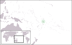
Tokelau comprises three atolls in the South Pacific Ocean between 171° and 173° W longitude and 8° and 10° S latitude, approximately midway between Hawaiʻi and New Zealand. They lie about 500 km north of Samoa.
The islands are Atafu (at one time known as the Duke of York Group), Nukunonu (also the Duke of Clarence Group), and Fakaofo (once Bowditch Island). Between them they comprise a land area of 10.8 km². They have no ports or harbours. Tokelau lies in the Pacific typhoon belt.
Territorial claim
A fourth island, historically and geographically but not politically, part of the Tokelau chain is Swains Island (Olohega), part of American Samoa since 1935. The island was claimed by the US pursuant to their Guano Islands Act, however, in the draft constitution subject to the Tokelau self-determination referendum, 2006, Swains Island is again claimed as part of Tokelau.
Economy
Tokelau is not a wealthy community, with a purchasing power of about €814 (US$1,000) per capita. The government is almost entirely dependent on subsidies from New Zealand. It has annual revenues of about €410,000 (less than US$500,000) against expenditures of €2.3 million (some US$2.8 million). The deficit is made up by aid from New Zealand. Tokelau exports around €80,000 (around US$100,000) of stamps, copra and handicrafts (woven and carved) and imports €245,000 (over US$300,000) of foodstuffs, building materials and fuel to and from New Zealand. New Zealand also pays directly for the cost of medical and education services.
A large number of Tokelauan people live in New Zealand and support their family in Tokelau by remittances.
Local industries include small-scale enterprises for copra production, wood work, plaited craft goods, stamps, coins, and fishing. Agriculture and livestock produces coconuts, copra, breadfruit, papayas, bananas, pigs, poultry and few goats.
Demographics
Tokelau has fewer than 1500 Polynesian inhabitants in three villages who speak Tokelauan and English. Their isolation and lack of resources greatly restrains economic development and confines agriculture to the subsistence level. The very limited natural resources and overcrowding are contributing to emigration to New Zealand, resulting in a population decline of about 0.9% per year. Depletion of tuna has made fishing for food more difficult.
On the island of Atafu all inhabitants are members of the Congregational Christian Church of Samoa. On Nukunonu all are Roman Catholic. On Fakaofo both denominations are present with the Congregational Christian Church predominant. The total proportions are: Congregational Christian Church 70%, Roman Catholic 28%, other 2%.
Internet domain names
Tokelau has an Internet country code top-level domain (ccTLD), .tk, and attempts to make money for the island by selling domain names. However, to gain publicity, Tokelau gives most domain names under its authority away to anyone for nothing. Free domains are pointed to Tokelau nameservers that redirect HTTP traffic via HTML frames to a specified web page and redirects 5 email addresses to external addresses. Only paid domains get the option of using a different nameserver (enabling more services and disabling the web/email forwarding).
Miscellaneous topics
Tokelau has radiotelephone service between the islands and to Samoa, and in 1997 established a government-regulated telephone service (TeleTok) with three satellite earth stations. Each atoll has a radio-broadcast station that broadcasts shipping and weather reports and every household has a radio or access to one.
In September 2003 Fakaofo became the first part of Tokelau with a high-speed internet connection. The service is free for everyone. Foundation Tokelau finances the project.
Ships load and unload cargo by motoring up to the down-wind (leeward) side of the islet where the people live and maintains station, by intermittant use of engines, close to the reef edge so that one or two whaleboats can be rowed out to transfer cargo to or from the shore. On return to shore the boats negotiate a narrow channel through the reef to the beach. Usually this landing is subject to ocean swell and beaching requires considerable skill and, often, coral abrasions to bodies.
If the current and wind are adverse for positioning close to the islet not much cargo movement can be done due to the great distances involved for the rowers. The ship stands off to wait suitable weather or goes off to one of the other atolls to attempt to load or unload its passengers or cargo, or both.
In late February and early March of 2005 Tokelau was struck and severely damaged by Cyclone Percy. It was stronger than forecast and stayed in the vicinity for longer than had been predicted. It coincided with a spring tide which put most of the area of the two villages on Fakaofo and Nukunonu under a metre of seawater. The cyclone also caused major erosion on several islets of all three atolls, damaging roads and bridges, and disrupting electric power and telecommunications systems. There was also significant and widespread damage to foodcrops including bananas, coconuts and pandanus. No one was seriously injured in the cyclone but villagers lost significant amounts of property.
The future for the Tokelau depends on the height of the ocean. No significant land is more than 2 metres above high water of ordinary tides. This means Tokelau is particularly vulnerable to any possible sea level rises caused by global warming.
See also
- Music of Tokelau
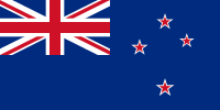
- Flag of Tokelau
External links
- TeleTok
- Dot TK site (.tk domain registry)
- Fakaofo – the website of one of the three atolls
- FAQs About Tokelau
- IANA contact information for the .tk domain
- Jane's Tokelau Islands Page
- Map of Tokelau
- Nukunonu – the website of one of the three atolls
- The Administrator of Tokelau (official government website)
- Tokelau Council of Ongoing Government (executive branch of government)
- World Factbook entry on Tokelau
- Song about Tokelau
- Tokelau-Info Project
- Tokelau vaka lualua project with the RGS
Template:New Zealand Template:Polynesia
| Countries and territories of Oceania | |
| Australia : Australia · Norfolk Island | |
| Melanesia : East Timor · Fiji · Maluku Islands & Western New Guinea (part of Indonesia) · New Caledonia · Papua New Guinea · Solomon Islands · Vanuatu | |
| Micronesia : Guam · Kiribati · Marshall Islands · Northern Mariana Islands · Federated States of Micronesia · Nauru · Palau · Wake Island | |
| Polynesia : American Samoa · Cook Islands · French Polynesia · Hawaii · New Zealand · Niue · Pitcairn Islands · Samoa · Tokelau · Tonga · Tuvalu · Wallis and Futuna | |


